859ea1546fa32f4b6cc3e070989546e6.ppt
- Количество слайдов: 61
 www. ec. gc. ca Meteorological Service of Canada Status Report NAEDEX-21 Meeting Asheville, North Carolina. 17 -19 Septembre 2008 Gilles Verner Chief, Data Assimilation and Quality Control Canadian Meteorological Centre Meteorological Service of Canada Mike Manore Director, Monitoring Strategies and Network Design Meteorological Service of Canada
 Outline • Current Operational Status: – – – Space Based Monitoring and Satellite reception facilities Computers and Telecoms Canadian AMDAR and other MSC observations Data issues and problems Operational NWP system at CMC and data usage • Recent changes and Future Developments: – – – ISO-9001 certification : forecast system New assimilation set-up for regional system and 06/18 Z runs Modification to EPS Incorporation of additional observations in assimilation Next version of global system (raised lid and new obs. ) New SST analysis NAEDEX-21 Asheville, NC. – September 17 -19, 2008 Meteorological Service of Canada Status Report
 Organizational Structure ‘Space-Based Monitoring’ - Environment Canada lead: Mike Manore 1. understanding satellite data requirements ▪ ▪ Environment Canada wide meteorological, climate, ice, marine oil spill, wildlife habitat, etc, …. 2. ensuring data access & exchange ▪ coordination/arrangements with satellite operators and other users – gov’t-to-gov’t, gov’t-to-agency, commercial – Mo. U with NOAA, Agreement with Eumetsat… – all appropriate missions and sensors ▪ operation of EC satellite data reception and processing systems – within Gov’t of Canada ‘Shared Federal Infrastructure’ – EC leadership for operational meteorological missions – operate as a national network: GOES- Alfheim; HRPT - Bradley ▪ future missions – influence future missions to meet EC requirements – Canada (CSA), International – E. g. CSA PCW mission NAEDEX-21 Asheville, NC. – September 17 -19, 2008 Meteorological Service of Canada Status Report
 CSA PCW Mission • Cooperation CSA, DND, EC • Concept of 2 satellites in HEO (Molniya 12 -hr • • • orbit) ABI-like imager, 2015 timeframe Proto-operational, North Polar areas only (Nof 60) (2 other sat. needed for South Polar areas) Phase 0 just completed Phase A kick-off next week, opportunities for cooperation to be examined Mission funding not yet secured EC: Louis Garand, Mike Manore, Gilles Verner NAEDEX-21 Asheville, NC. – September 17 -19, 2008 Meteorological Service of Canada Status Report
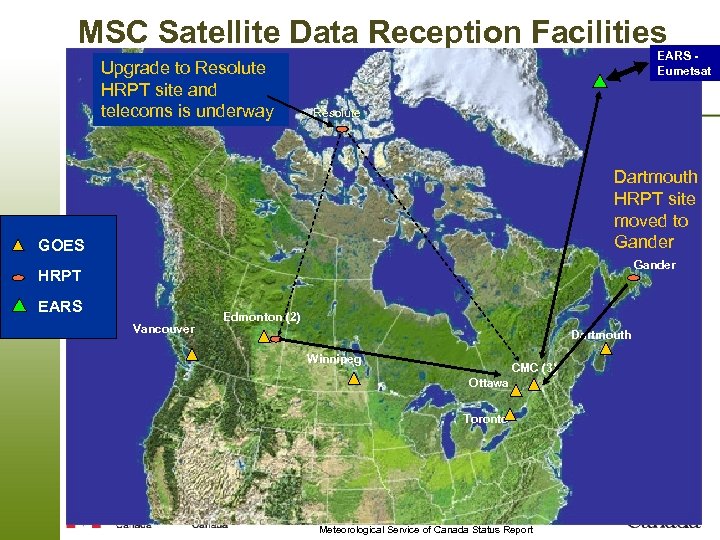 MSC Satellite Data Reception Facilities Upgrade to Resolute HRPT site and telecoms is underway EARS Eumetsat Resolute Dartmouth HRPT site moved to Gander GOES Gander HRPT EARS Vancouver Edmonton (2) Dartmouth Winnipeg CMC (3) Ottawa Toronto NAEDEX-21 Asheville, NC. – September 17 -19, 2008 Meteorological Service of Canada Status Report
 Canada-EUMETSAT Cooperation Agreement • Signed Fall 2007 • 8 areas of cooperation – – – science and product development ▪ participation in SAFs, visiting scientists optimize data acquisition and exchange of satellite data and products ▪ specific agreements –e. g. , EARS define requirements and opportunities to improve high-latitude observations explore options for Canada to contribute to EUMETSAT mission instruments ▪ build on CSA associate membership in ESA share training experience and materials – cooperation in GEO, including projects in developing countries ▪ GEONETCast exchange views on matters of satellites and satellite meteorology – explore possibilities for longer term cooperation NAEDEX-21 Asheville, NC. – September 17 -19, 2008 Meteorological Service of Canada Status Report
 Computers and Telecoms • Final upgrade to IBM: 2 clusters, upgrade is underway: – – current is OPS: 40 nodes, and R&D: 60 nodes to reach OPS/DEV: 80/120 nodes by Dec 08, and to reach 80/180 nodes by June 09 Total of 4512 P 5+ processors (9024 virtual) by mid 2009 • New procurement for 2010 -11 • Upgrade to SGI-FE’s: 2 x capacity, replacement with • • • Linux clusters underway CFS: 2 PB tape capacity Links to NOAA-TOC (GTS), UKMet. O (Sat data + GTS back-up), EUMETSAT (EARS) Link to NOAA-NESDIS soon (may be done by now) Internet still used for much satellite data Eumet. Cast / Geo. Net. Cast being considered NAEDEX-21 Asheville, NC. – September 17 -19, 2008 Meteorological Service of Canada Status Report
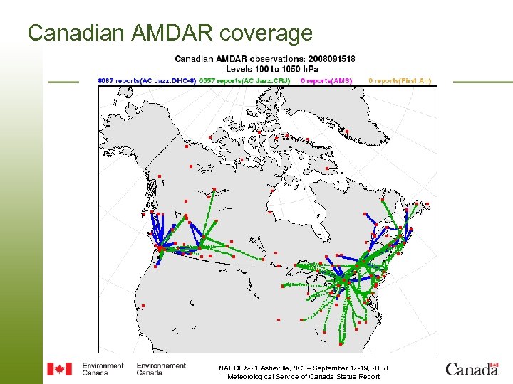 Canadian AMDAR coverage NAEDEX-21 Asheville, NC. – September 17 -19, 2008 Meteorological Service of Canada Status Report
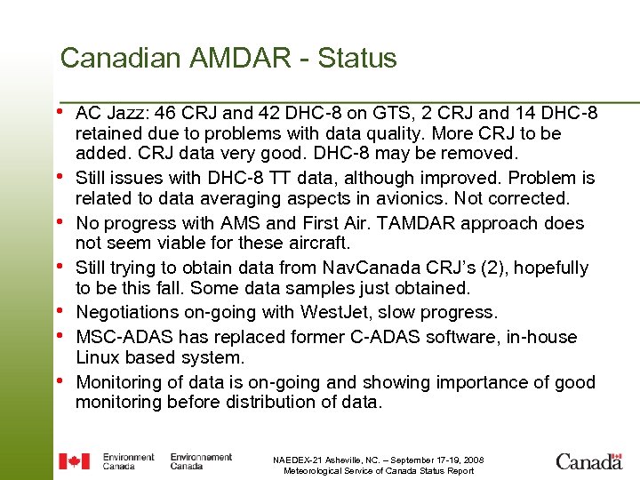 Canadian AMDAR - Status • AC Jazz: 46 CRJ and 42 DHC-8 on GTS, 2 CRJ and 14 DHC-8 • • • retained due to problems with data quality. More CRJ to be added. CRJ data very good. DHC-8 may be removed. Still issues with DHC-8 TT data, although improved. Problem is related to data averaging aspects in avionics. Not corrected. No progress with AMS and First Air. TAMDAR approach does not seem viable for these aircraft. Still trying to obtain data from Nav. Canada CRJ’s (2), hopefully to be this fall. Some data samples just obtained. Negotiations on-going with West. Jet, slow progress. MSC-ADAS has replaced former C-ADAS software, in-house Linux based system. Monitoring of data is on-going and showing importance of good monitoring before distribution of data. NAEDEX-21 Asheville, NC. – September 17 -19, 2008 Meteorological Service of Canada Status Report
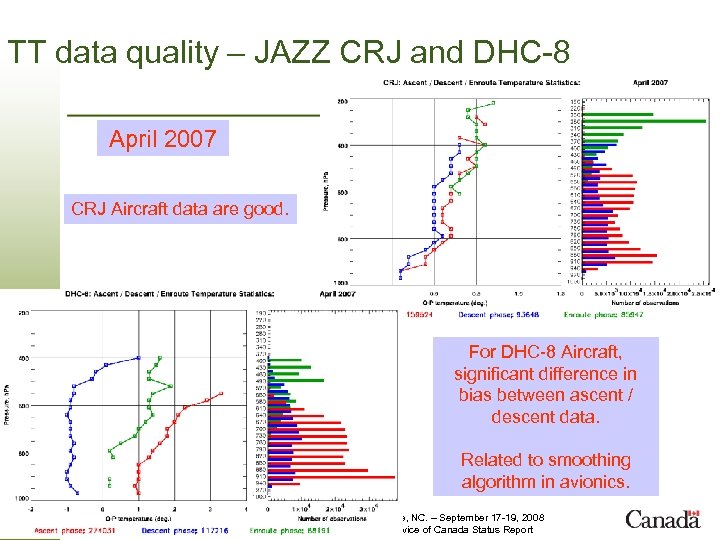 TT data quality – JAZZ CRJ and DHC-8 April 2007 CRJ Aircraft data are good. For DHC-8 Aircraft, significant difference in bias between ascent / descent data. Related to smoothing algorithm in avionics. NAEDEX-21 Asheville, NC. – September 17 -19, 2008 Meteorological Service of Canada Status Report
 Other Canadian observations • “Synoptic” observations from CTBTO network, using SYNOP MOBIL code, • • • header: SNCN 19 CWAO. Observations every 10 -min, 10 stations for now but should increase, received at CMC by e-mail: data problems as reported by Met. Office : surface elevations not available or wrong. Canadian radar data - now available centrally at CMC, NRP (National Radar Processor) operational, full volume scans available. Provided to NOAA. Forestry and Road weather stations in British Columbia - data received at CMC, in old SA format. Data redistribution restrictions currently apply…should eventually be available in BUFR. Co-operative network in Quebec (Province, Hydro-Quebec, etc), received at CMC, also redistribution restrictions…problems with BUFR data. Some research wind profilers in Southern Ontario and Quebec: operated by Universities, data now available to CMC and should be inserted on GTS in the near future, in BUFR code: headers to be communicated as soon as available. Some soil TT data now available, eventually in BUFR. New equipment for radiosondes. Should improve wind quality, also includes provision for 4 D data in BUFR. Data available at stations but not yet on GTS. Ozone soundings on GTS (KULA 01 CWAO) and total column ozone. Major data management project in MSC, should lead to all data available in BUFR. Potential development of surface GPS Network. Lead: Godelieve Deblonde. Surface Weather stations for 2010 Olympics (Whistler) already on GTS. NAEDEX-21 Asheville, NC. – September 17 -19, 2008 Meteorological Service of Canada Status Report
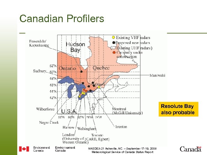 Canadian Profilers Resolute Bay also probable NAEDEX-21 Asheville, NC. – September 17 -19, 2008 Meteorological Service of Canada Status Report
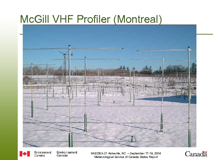 Mc. Gill VHF Profiler (Montreal) NAEDEX-21 Asheville, NC. – September 17 -19, 2008 Meteorological Service of Canada Status Report
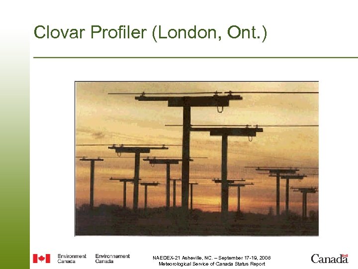 Clovar Profiler (London, Ont. ) NAEDEX-21 Asheville, NC. – September 17 -19, 2008 Meteorological Service of Canada Status Report
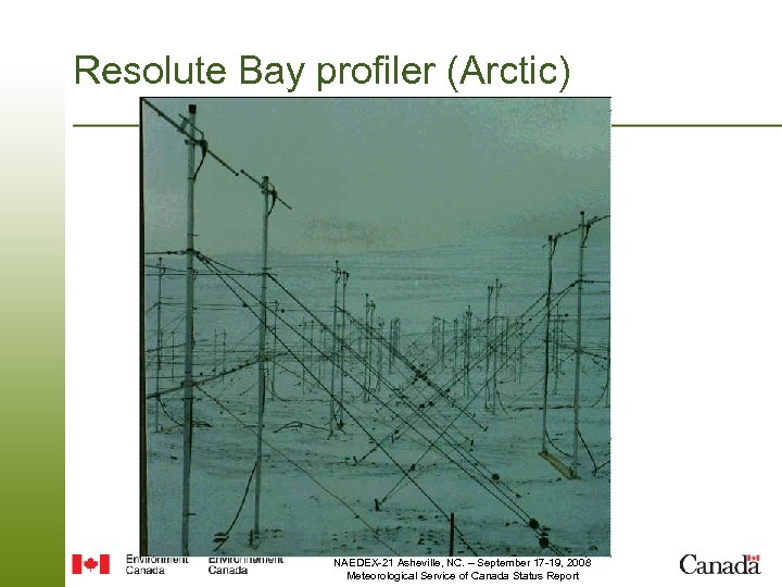 Resolute Bay profiler (Arctic) NAEDEX-21 Asheville, NC. – September 17 -19, 2008 Meteorological Service of Canada Status Report
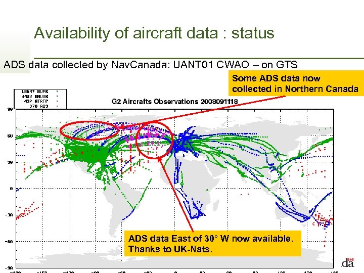 Availability of aircraft data : status ADS data collected by Nav. Canada: UANT 01 CWAO – on GTS Some ADS data now collected in Northern Canada ADS data East of 30° W now available. Thanks to UK-Nats. NAEDEX-21 Asheville, NC. – September 17 -19, 2008 Meteorological Service of Canada Status Report
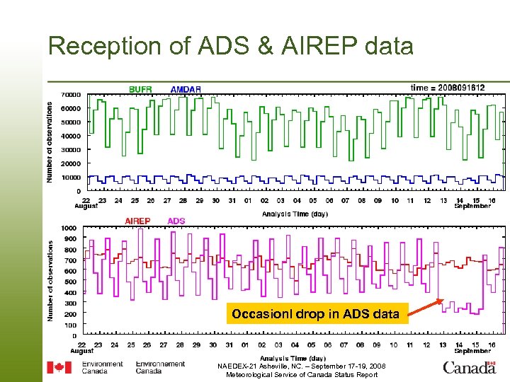 Reception of ADS & AIREP data Occasionl drop in ADS data NAEDEX-21 Asheville, NC. – September 17 -19, 2008 Meteorological Service of Canada Status Report
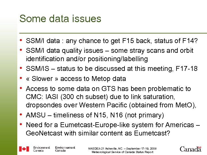 Some data issues • SSM/I data : any chance to get F 15 back, status of F 14? • SSM/I data quality issues – some stray scans and orbit • • • identification and/or positioning/labelling SSM/IS – status to be discussed at this meeting, F 17 -18 « Slower » access to Metop data Access to some data on GTS has been problematic to CMC: IASI (300 ch subset) due to link saturation, dropsondes over Western Pacific (obtained from Met. O), AMSU – timeliness of N 15, N 16 (not primary) Need for a Eumetcast-Europe-like system for Americas – Geo. Netcast with similar content as Eumetcast? NAEDEX-21 Asheville, NC. – September 17 -19, 2008 Meteorological Service of Canada Status Report
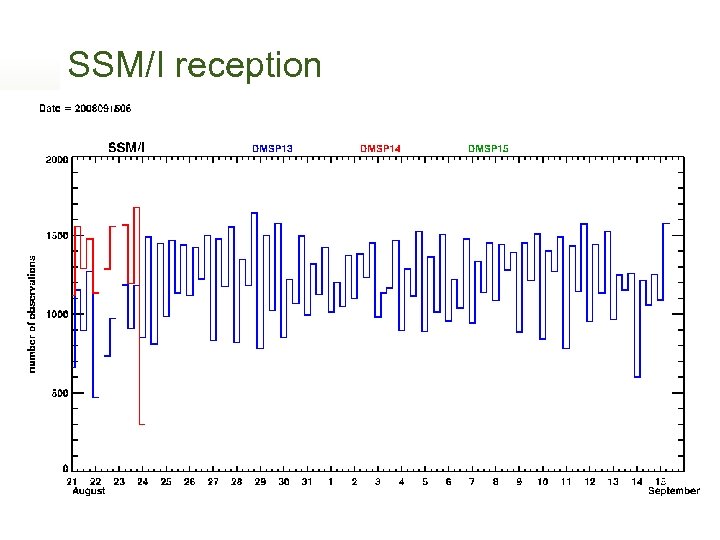 SSM/I reception NAEDEX-21 Asheville, NC. – September 17 -19, 2008 Meteorological Service of Canada Status Report
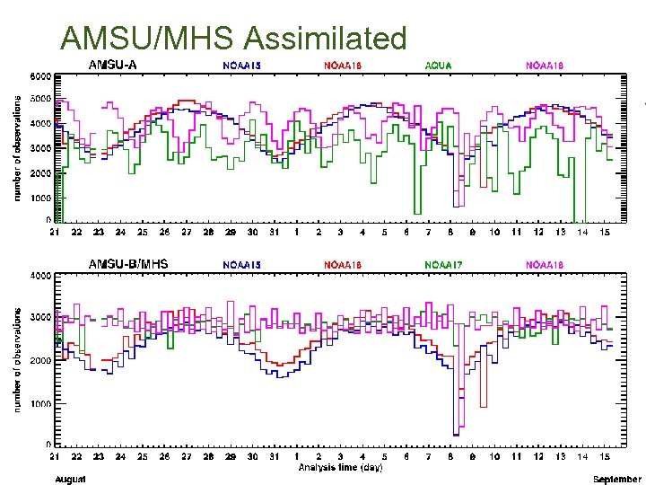 AMSU/MHS Assimilated NAEDEX-21 Asheville, NC. – September 17 -19, 2008 Meteorological Service of Canada Status Report
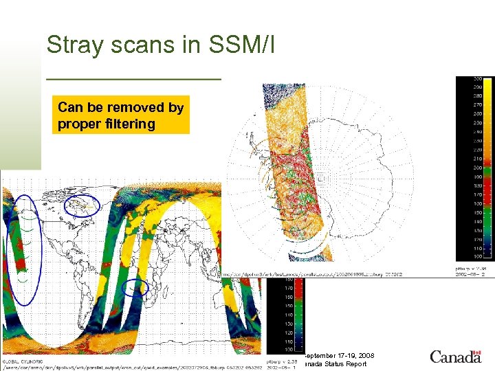 Stray scans in SSM/I Can be removed by proper filtering NAEDEX-21 Asheville, NC. – September 17 -19, 2008 Meteorological Service of Canada Status Report
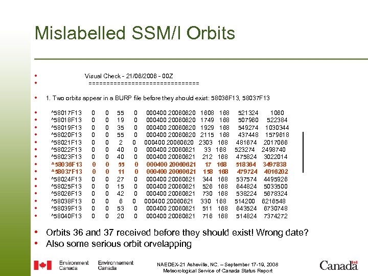 Mislabelled SSM/I Orbits • • Visual Check - 21/06/2006 - 00 Z ================ • 1. Two orbits appear in a BURP file before they should exist: 58036 F 13, 58037 F 13 • • • • ^58017 F 13 0 0 55 0 000400 20060620 1608 168 521324 1060 ^58018 F 13 0 0 19 0 000400 20060620 1749 168 507960 522384 ^58019 F 13 0 0 35 0 000400 20060620 1929 168 549274 1030344 ^58020 F 13 0 0 55 0 000400 20060620 2115 168 437448 1579618 ^58021 F 13 0 0 2 0 000400 20060620 2303 168 481674 2017066 ^58022 F 13 0 0 40 0 000400 20060621 33 168 523274 2498740 ^58023 F 13 0 0 40 0 000400 20060621 212 168 475824 3022014 ^58036 F 13 0 0 55 0 000400 20060621 17 168 518364 3497838 ^58037 F 13 0 0 11 0 000400 20060621 158 168 479724 4016202 ^58024 F 13 0 0 27 0 000400 20060621 344 168 537574 4495926 ^58025 F 13 0 0 15 0 000400 20060621 526 168 644824 5033500 ^58026 F 13 0 0 42 0 000400 20060621 730 168 538224 5678324 ^58038 F 13 0 0 6 0 000400 20060621 330 168 514200 6216548 ^58039 F 13 0 0 53 0 000400 20060621 511 168 643524 6730748 ^58040 F 13 0 0 20 0 000400 20060621 716 168 514824 7374272 • Orbits 36 and 37 received before they should exist! Wrong date? • Also some serious orbit orvelapping NAEDEX-21 Asheville, NC. – September 17 -19, 2008 Meteorological Service of Canada Status Report
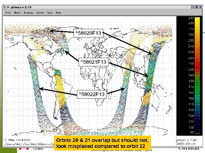 ^58020 F 13 ^58021 F 13 ^58022 F 13 Orbits 20 & 21 overlap but should not, NAEDEX-21 Asheville, NC. – September 17 -19, 2008 look misplaced compared to orbit 22 Meteorological Service of Canada Status Report
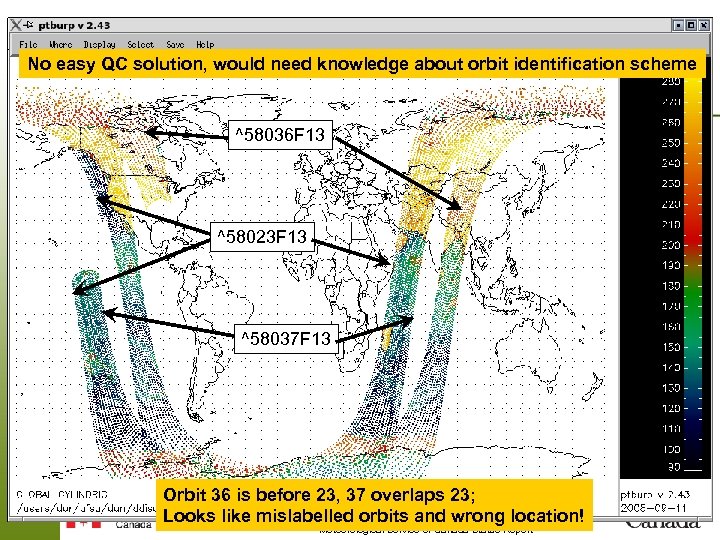 No easy QC solution, would need knowledge about orbit identification scheme ^58036 F 13 ^58023 F 13 ^58037 F 13 Orbit 36 is before 23, 37 overlaps 23; NAEDEX-21 Asheville, NC. – September 17 -19, 2008 Looks like mislabelled orbits and wrong location! Meteorological Service of Canada Status Report
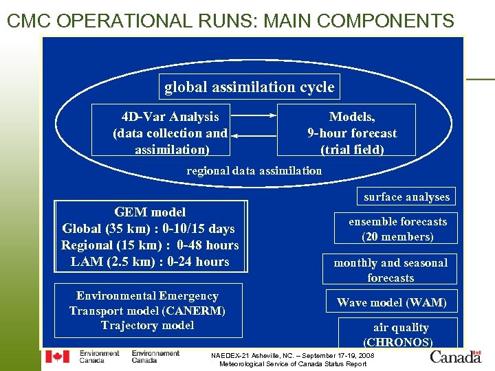 CMC OPERATIONAL RUNS: MAIN COMPONENTS global assimilation cycle 4 D-Var Analysis (data collection and assimilation) Models, 9 -hour forecast (trial field) regional data assimilation surface analyses GEM model Global (35 km) 0 -10/15 days Global (100 km) : : 0 -10/15 days Regional (15 km) : 0 -48 hours Regional (15 km) : 0 -48 hours LAM (2. 5 km) 0 -24 hours HIMAP (10 km): : 0 -24 hours Environmental Emergency Transport model (CANERM) Trajectory model ensemble forecasts (20 members) monthly and seasonal forecasts Wave model (WAM) air quality (CHRONOS) NAEDEX-21 Asheville, NC. – September 17 -19, 2008 Meteorological Service of Canada Status Report
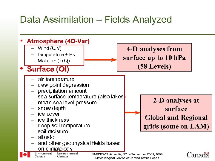 Data Assimilation – Fields Analyzed • Atmosphere (4 D-Var) – Wind (U, V) – temperature + Ps – Moisture (ln Q) • Surface (OI) – – – 4 -D analyses from surface up to 10 h. Pa (58 Levels) air temperature dew point depression precipitation amount sea surface temperature (also lakes) mean sea level pressure snow depth ice cover ice thickness deep soil temperature soil moisture albedo and other geophysical fields based on climatology 2 -D analyses at surface Global and Regional grids (some on LAM) NAEDEX-21 Asheville, NC. – September 17 -19, 2008 Meteorological Service of Canada Status Report
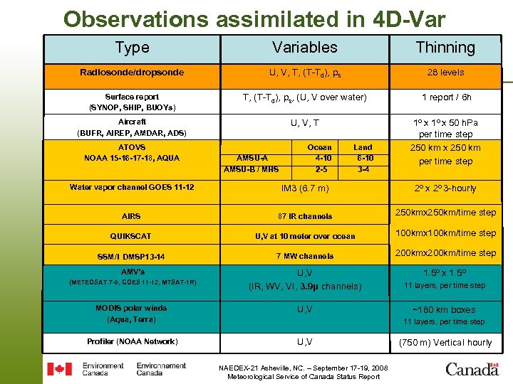 Observations assimilated in 4 D-Var Type Variables Thinning Radiosonde/dropsonde U, V, T, (T-T d), ps 28 levels Surface report (SYNOP, SHIP, BUOYs) T, (T-Td), ps, (U, V over water) 1 report / 6 h Aircraft (BUFR, AIREP, AMDAR, ADS) U, V, T 1 o x 50 h. Pa per time step ATOVS NOAA 15 -16 -17 -18, AQUA Water vapor channel GOES 11 -12 AIRS QUIKSCAT AMSU-A AMSU-B / MHS Ocean 4 -10 2 -5 IM 3 (6. 7 m) 87 IR channels Land 6 -10 3 -4 250 km x 250 km per time step 2 o x 2 o 3 -hourly 250 kmx 250 km/time step U, V at 10 meter over ocean 100 kmx 100 km/time step 200 kmx 200 km/time step SSM/I DMSP 13 -14 7 MW channels AMV’s U, V (IR, WV, VI, 3. 9μ channels) 11 layers, per time step MODIS polar winds (Aqua, Terra) U, V ~180 km boxes Profiler (NOAA Network) U, V (METEOSAT 7 -9, GOES 11 -12, MTSAT-1 R) 1. 5 o x 1. 5 o 11 layers, per time step NAEDEX-21 Asheville, NC. – September 17 -19, 2008 Meteorological Service of Canada Status Report (750 m) Vertical hourly
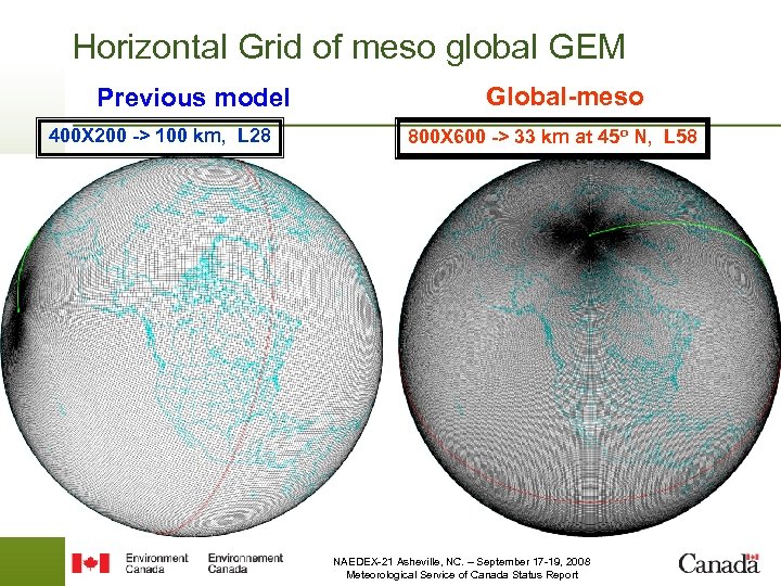 Horizontal Grid of meso global GEM Previous model 400 X 200 -> 100 km, L 28 Global-meso 800 X 600 -> 33 km at 45 o N, L 58 NAEDEX-21 Asheville, NC. – September 17 -19, 2008 Meteorological Service of Canada Status Report
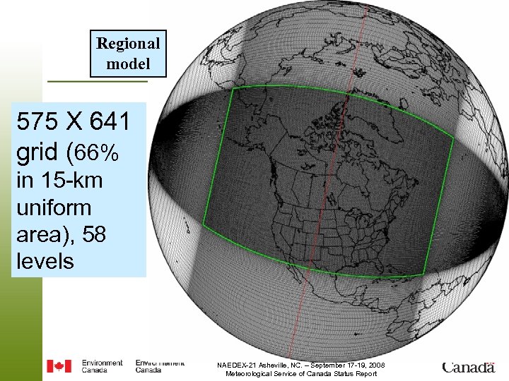 Regional model 575 X 641 grid (66% in 15 -km uniform area), 58 levels NAEDEX-21 Asheville, NC. – September 17 -19, 2008 Meteorological Service of Canada Status Report
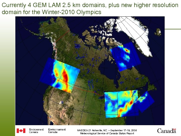 Currently 4 GEM LAM 2. 5 km domains, plus new higher resolution domain for the Winter-2010 Olympics Topography at 2. 5 km NAEDEX-21 Asheville, NC. – September 17 -19, 2008 Meteorological Service of Canada Status Report
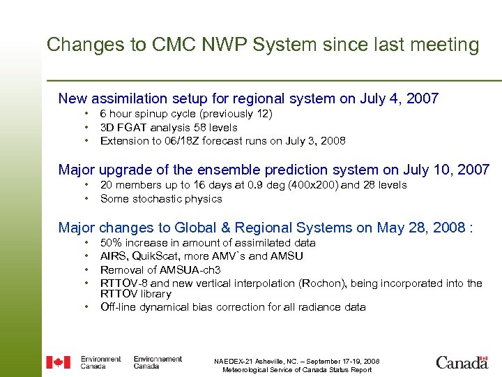 Changes to CMC NWP System since last meeting New assimilation setup for regional system on July 4, 2007 • • • 6 hour spinup cycle (previously 12) 3 D FGAT analysis 58 levels Extension to 06/18 Z forecast runs on July 3, 2008 Major upgrade of the ensemble prediction system on July 10, 2007 • • 20 members up to 16 days at 0. 9 deg (400 x 200) and 28 levels Some stochastic physics Major changes to Global & Regional Systems on May 28, 2008 : • • • 50% increase in amount of assimilated data AIRS, Quik. Scat, more AMV`s and AMSU Removal of AMSUA-ch 3 RTTOV-8 and new vertical interpolation (Rochon), being incorporated into the RTTOV library Off-line dynamical bias correction for all radiance data NAEDEX-21 Asheville, NC. – September 17 -19, 2008 Meteorological Service of Canada Status Report
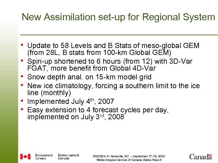 New Assimilation set-up for Regional System • Update to 58 Levels and B Stats of meso-global GEM • • • (from 28 L, B stats from 100 -km Global GEM) Spin-up shortened to 6 hours (from 12) with 3 D-Var FGAT, more benefit from Global 4 D-Var Snow depth anal. on 15 -km model grid New ice climatology, forcing a southern limit to the ice line (monthly) Implemented July 4 th, 2007 Easy extension to 4 forecast cycles per day, implemented on July 3 rd, 2008 NAEDEX-21 Asheville, NC. – September 17 -19, 2008 Meteorological Service of Canada Status Report
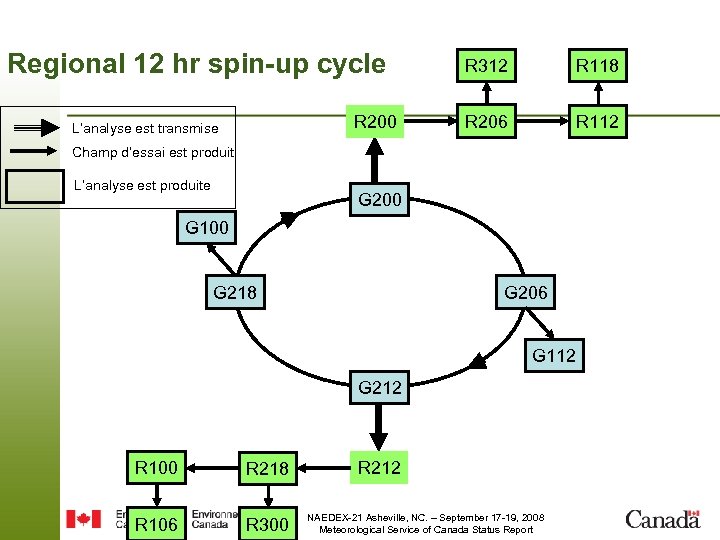 Regional 12 hr spin-up cycle R 200 L’analyse est transmise R 312 R 118 R 206 R 112 Champ d’essai est produit L’analyse est produite G 200 G 100 G 218 G 206 G 112 G 212 R 100 R 218 R 106 R 300 R 212 NAEDEX-21 Asheville, NC. – September 17 -19, 2008 Meteorological Service of Canada Status Report
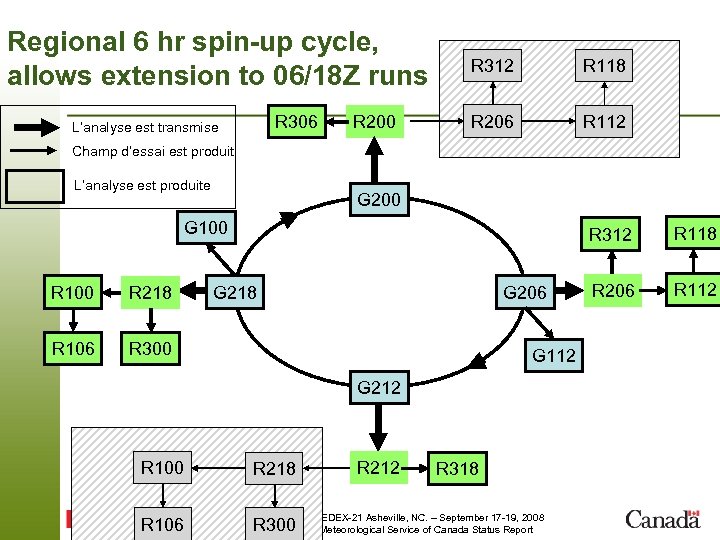 Regional 6 hr spin-up cycle, allows extension to 06/18 Z runs R 306 L’analyse est transmise R 200 R 312 R 118 R 206 R 112 Champ d’essai est produit L’analyse est produite G 200 G 100 R 218 R 106 R 312 G 218 G 206 R 300 G 112 G 212 R 100 R 218 R 106 R 300 R 212 R 318 NAEDEX-21 Asheville, NC. – September 17 -19, 2008 Meteorological Service of Canada Status Report R 118 R 206 R 112
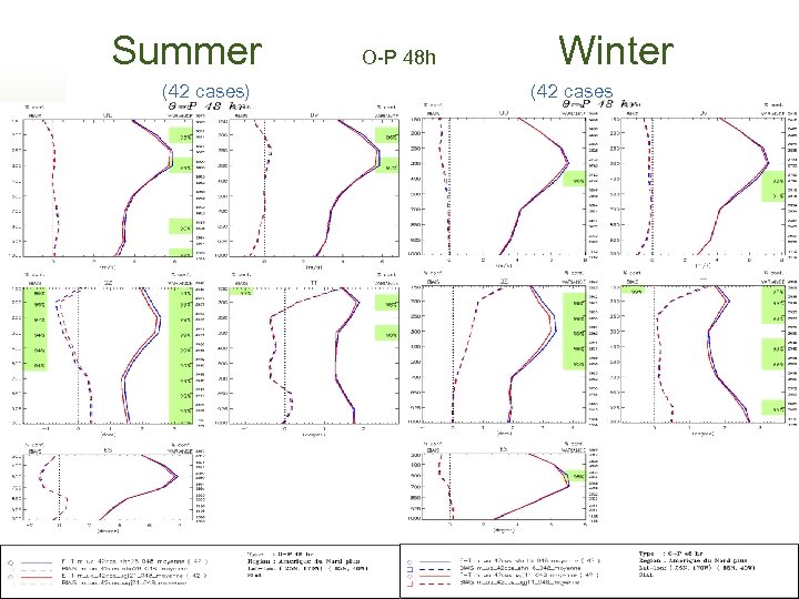 Summer O-P 48 h Winter (42 cases) (42 cases NAEDEX-21 Asheville, NC. – September 17 -19, 2008 Meteorological Service of Canada Status Report
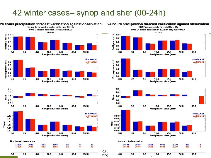 42 winter cases– synop and shef (00 -24 h) NAEDEX-21 Asheville, NC. – September 17 -19, 2008 Meteorological Service of Canada Status Report
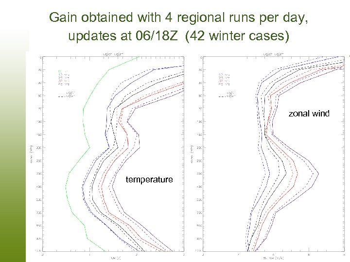 Gain obtained with 4 regional runs per day, updates at 06/18 Z (42 winter cases) zonal wind std zonal wind temperature NAEDEX-21 Asheville, NC. – September 17 -19, 2008 Meteorological Service of Canada Status Report
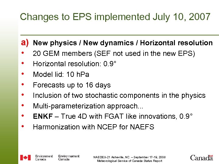 Changes to EPS implemented July 10, 2007 a) • • New physics / New dynamics / Horizontal resolution 20 GEM members (SEF not used in the new EPS) Horizontal resolution: 0. 9° Model lid: 10 h. Pa Forecasts up to 16 days Inclusion of two stochastic components in the physics Multi-parameterization approach. . . ENKF – True 4 D with FGAT like innovations, 0. 9° Harmonization with NCEP for NAEFS NAEDEX-21 Asheville, NC. – September 17 -19, 2008 Meteorological Service of Canada Status Report
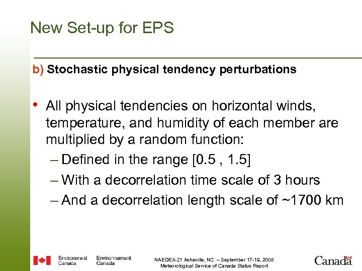 New Set-up for EPS b) Stochastic physical tendency perturbations • All physical tendencies on horizontal winds, temperature, and humidity of each member are multiplied by a random function: – Defined in the range [0. 5 , 1. 5] – With a decorrelation time scale of 3 hours – And a decorrelation length scale of ~1700 km NAEDEX-21 Asheville, NC. – September 17 -19, 2008 Meteorological Service of Canada Status Report
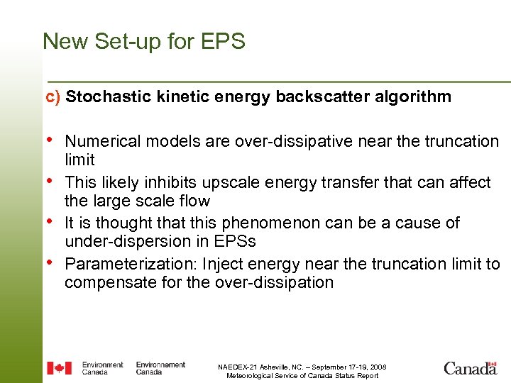 New Set-up for EPS c) Stochastic kinetic energy backscatter algorithm • Numerical models are over-dissipative near the truncation • • • limit This likely inhibits upscale energy transfer that can affect the large scale flow It is thought that this phenomenon can be a cause of under-dispersion in EPSs Parameterization: Inject energy near the truncation limit to compensate for the over-dissipation NAEDEX-21 Asheville, NC. – September 17 -19, 2008 Meteorological Service of Canada Status Report
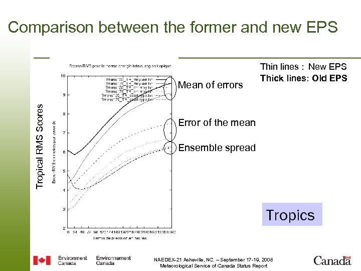 Comparison between the former and new EPS Tropical RMS Scores Mean of errors Thin lines : New EPS Thick lines: Old EPS Error of the mean Ensemble spread Tropics NAEDEX-21 Asheville, NC. – September 17 -19, 2008 Meteorological Service of Canada Status Report
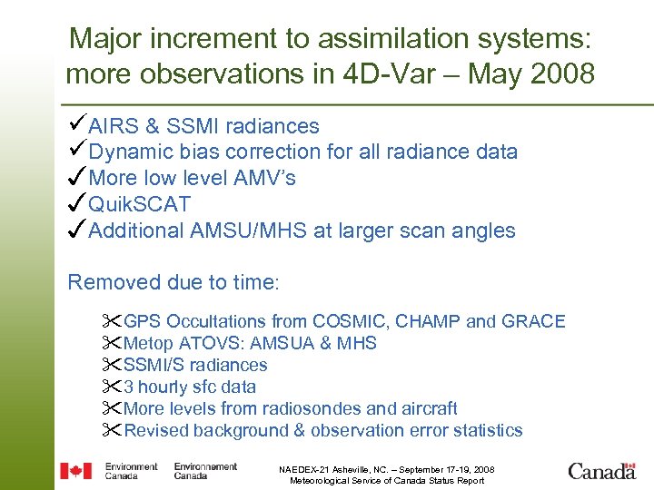 Major increment to assimilation systems: more observations in 4 D-Var – May 2008 üAIRS & SSMI radiances üDynamic bias correction for all radiance data ✓More low level AMV’s ✓Quik. SCAT ✓Additional AMSU/MHS at larger scan angles Removed due to time: "GPS Occultations from COSMIC, CHAMP and GRACE "Metop ATOVS: AMSUA & MHS "SSMI/S radiances "3 hourly sfc data "More levels from radiosondes and aircraft "Revised background & observation error statistics NAEDEX-21 Asheville, NC. – September 17 -19, 2008 Meteorological Service of Canada Status Report
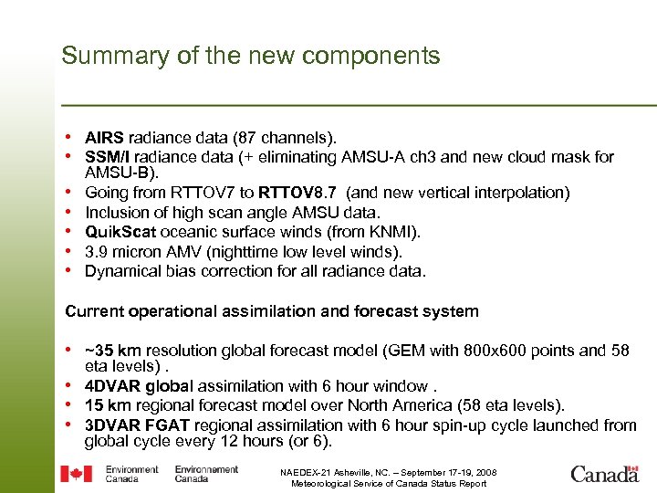 Summary of the new components • AIRS radiance data (87 channels). • SSM/I radiance data (+ eliminating AMSU-A ch 3 and new cloud mask for • • • AMSU-B). Going from RTTOV 7 to RTTOV 8. 7 (and new vertical interpolation) Inclusion of high scan angle AMSU data. Quik. Scat oceanic surface winds (from KNMI). 3. 9 micron AMV (nighttime low level winds). Dynamical bias correction for all radiance data. Current operational assimilation and forecast system • ~35 km resolution global forecast model (GEM with 800 x 600 points and 58 eta levels). • 4 DVAR global assimilation with 6 hour window. • 15 km regional forecast model over North America (58 eta levels). • 3 DVAR FGAT regional assimilation with 6 hour spin-up cycle launched from global cycle every 12 hours (or 6). NAEDEX-21 Asheville, NC. – September 17 -19, 2008 Meteorological Service of Canada Status Report
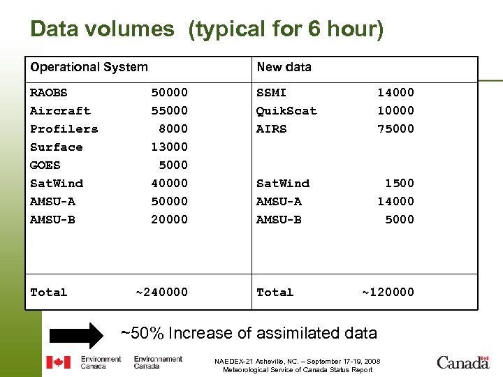 Data volumes (typical for 6 hour) Operational System RAOBS Aircraft Profilers Surface GOES Sat. Wind AMSU-A AMSU-B Total New data 50000 55000 8000 13000 5000 40000 50000 20000 ~240000 SSMI Quik. Scat AIRS 14000 10000 75000 Sat. Wind AMSU-A AMSU-B 1500 14000 5000 Total ~120000 ~50% Increase of assimilated data NAEDEX-21 Asheville, NC. – September 17 -19, 2008 Meteorological Service of Canada Status Report
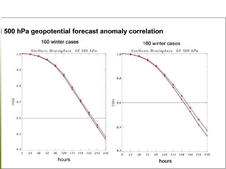 NAEDEX-21 Asheville, NC. – September 17 -19, 2008 Meteorological Service of Canada Status Report
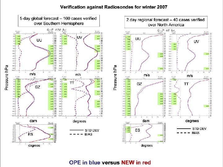 NAEDEX-21 Asheville, NC. – September 17 -19, 2008 Meteorological Service of Canada Status Report
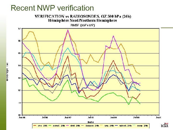 Recent NWP verification NAEDEX-21 Asheville, NC. – September 17 -19, 2008 Meteorological Service of Canada Status Report
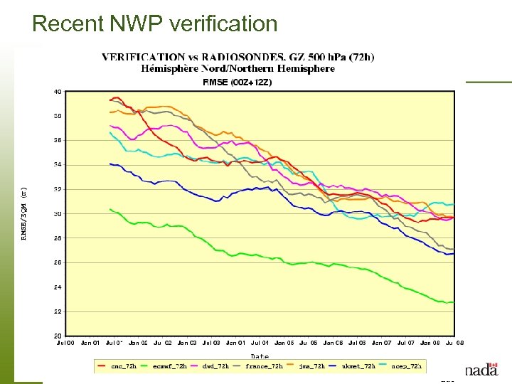 Recent NWP verification NAEDEX-21 Asheville, NC. – September 17 -19, 2008 Meteorological Service of Canada Status Report
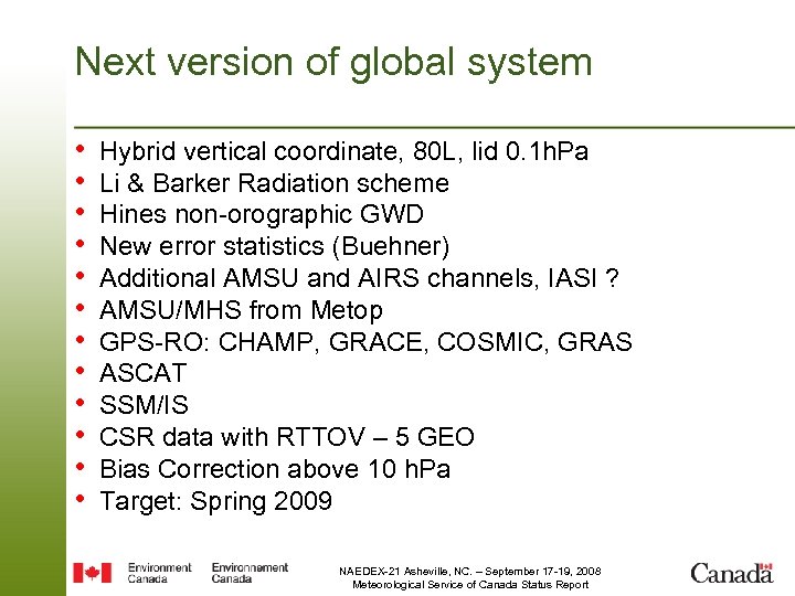 Next version of global system • • • Hybrid vertical coordinate, 80 L, lid 0. 1 h. Pa Li & Barker Radiation scheme Hines non-orographic GWD New error statistics (Buehner) Additional AMSU and AIRS channels, IASI ? AMSU/MHS from Metop GPS-RO: CHAMP, GRACE, COSMIC, GRAS ASCAT SSM/IS CSR data with RTTOV – 5 GEO Bias Correction above 10 h. Pa Target: Spring 2009 NAEDEX-21 Asheville, NC. – September 17 -19, 2008 Meteorological Service of Canada Status Report
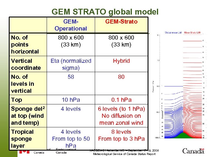 GEM STRATO global model GEMOperational No. of points horizontal Vertical coordinate GEM-Strato 800 x 600 (33 km) 800 x 600 (33 km) Eta (normalized sigma) Hybrid 58 80 Top 10 h. Pa 0. 1 h. Pa Sponge del 2 at top (wind and temp) 4 levels 6 levels (to 1 h. Pa) No diffusion on mean zonal wind 4 levels From top to 50 h. Pa 8 levels From top to 3 h. Pa No. of levels in vertical Tropical sponge layer NAEDEX-21 Asheville, NC. – September 17 -19, 2008 Meteorological Service of Canada Status Report
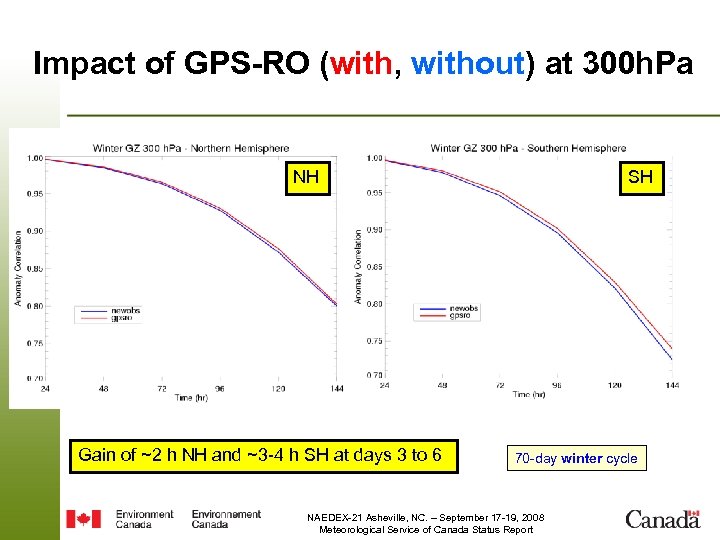 Impact of GPS-RO (with, without) at 300 h. Pa NH Gain of ~2 h NH and ~3 -4 h SH at days 3 to 6 SH 70 -day winter cycle NAEDEX-21 Asheville, NC. – September 17 -19, 2008 Meteorological Service of Canada Status Report
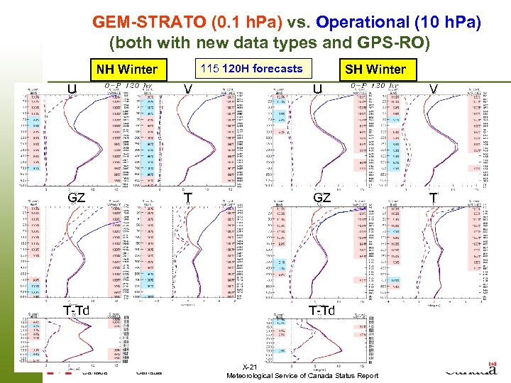 GEM-STRATO (0. 1 h. Pa) vs. Operational (10 h. Pa) (both with new data types and GPS-RO) 115 120 H forecasts NH Winter SH Winter U V GZ T T-Td NAEDEX-21 Asheville, NC. – September 17 -19, 2008 Meteorological Service of Canada Status Report
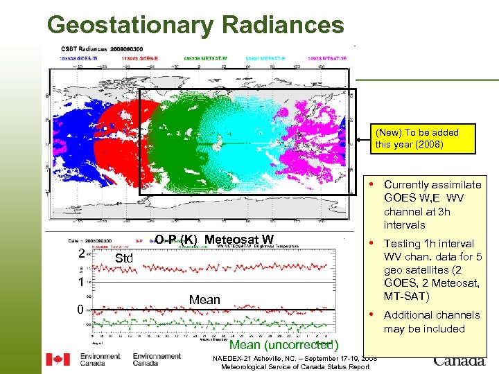 Geostationary Radiances (New) To be added this year (2008) • Currently assimilate GOES W, E WV channel at 3 h intervals O-P (K) Meteosat W 2 • Testing 1 h interval WV chan. data for 5 geo satellites (2 GOES, 2 Meteosat, MT-SAT) Std 1 0 Mean • Additional channels may be included Mean (uncorrected) NAEDEX-21 Asheville, NC. – September 17 -19, 2008 Meteorological Service of Canada Status Report
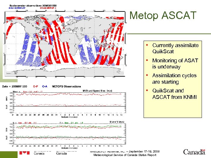 Metop ASCAT • Currently assimilate Quik. Scat • Monitoring of ASAT is underway • Assimilation cycles are starting • Quik. Scat and ASCAT from KNMI NAEDEX-21 Asheville, NC. – September 17 -19, 2008 Meteorological Service of Canada Status Report
 New CMC SST ANALYSIS Bruce Brasnett Data Assimilation and Quality Control Division Canadian Meteorological Centre September, 2008
 Data Sources • AVHRR 17 & AVHRR 18 via ftp from PO-DAAC • • • (retrievals from Naval Oceanographic Office) AMSR-E via ftp from Remote Sensing Systems Inc. A/ATSR via ftp from ESA (ATS MET data) Ships, drifters and moored buoys • Using OI on 1080 x 540 grid (0. 33 deg) • Once a day • Published in Sept. 08 QJRMS, 134 NAEDEX-21 Asheville, NC. – September 17 -19, 2008 Meteorological Service of Canada Status Report
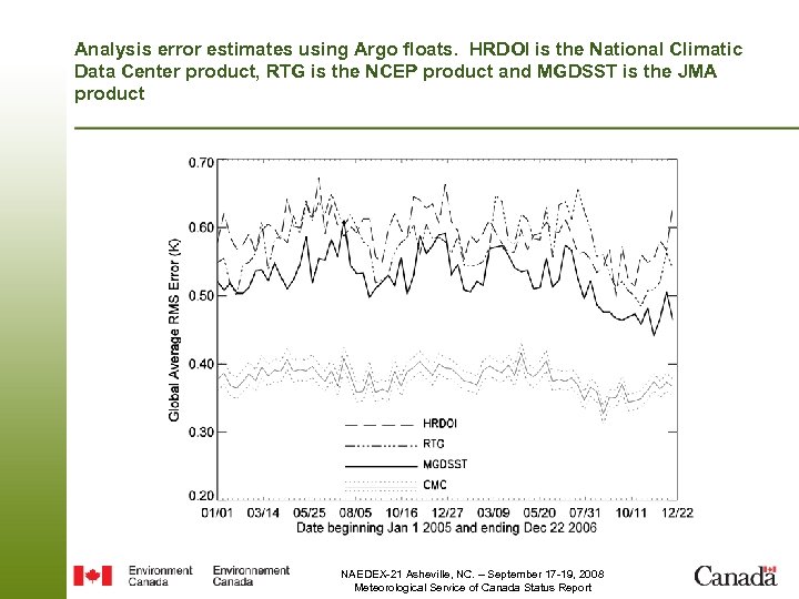 Analysis error estimates using Argo floats. HRDOI is the National Climatic Data Center product, RTG is the NCEP product and MGDSST is the JMA product NAEDEX-21 Asheville, NC. – September 17 -19, 2008 Meteorological Service of Canada Status Report
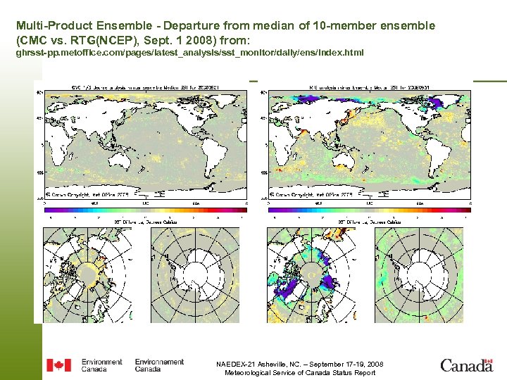 Multi-Product Ensemble - Departure from median of 10 -member ensemble (CMC vs. RTG(NCEP), Sept. 1 2008) from: ghrsst-pp. metoffice. com/pages/latest_analysis/sst_monitor/daily/ens/index. html NAEDEX-21 Asheville, NC. – September 17 -19, 2008 Meteorological Service of Canada Status Report
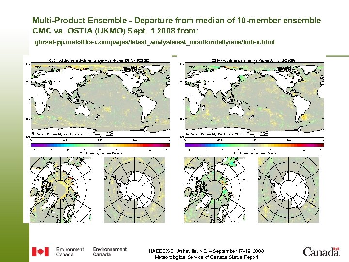 Multi-Product Ensemble - Departure from median of 10 -member ensemble CMC vs. OSTIA (UKMO) Sept. 1 2008 from: ghrsst-pp. metoffice. com/pages/latest_analysis/sst_monitor/daily/ens/index. html NAEDEX-21 Asheville, NC. – September 17 -19, 2008 Meteorological Service of Canada Status Report
 Monitoring Web sites • http: //collaboration. cmc. eg. gc. ca/cmc/data_monitoring/CAMDAR • http: //collaboration. cmc. eg. gc. ca/cmc/data_monitoring/SAR • User: monitoring PW: CMC NAEDEX-21 Asheville, NC. – September 17 -19, 2008 Meteorological Service of Canada Status Report
 www. ec. gc. ca NAEDEX-21 Asheville, NC. – September 17 -19, 2008 Meteorological Service of Canada Status Report


