4af482a592f2f8bae7216107ec527cae.ppt
- Количество слайдов: 58
 World Political Map Many people equate geography with memorizing countries and capitals. (Perhaps you did too before taking this course. )
 As seen from space, these imaginary lines we draw on the earth’s surface disappear, right?
 “I really believe that if the political leaders of the world could see their planet from a distance of 100, 000 miles, their outlook would fundamentally change. Those allimportant borders would be invisible, and their noisy arguments would be silenced. ” Michael Collins, Gemini 10 & Apollo 11 astronaut
 Collins’ quote is just one example of an oft-repeated and beautiful idea: that one can’t see political borders from space. But is it true?
 Sadly, no. The Pakistan-India from the North from the ISS, August 7, 2011. Since 2003, India has illuminated the border with Pakistan by floodlights in attempt to prevent ammunition trafficking and the infiltration of terrorists.
 The Koreas from space
 U. S. Canada border from space. Different land use practices in the two countries are apparent on this infrared satellite image. The fields in which wheat is actively growing are dark red. Fallow fields appear lighter in color although their shapes are the same.
 A clearly visible line marks about 50 kilometers of the international border between Egypt and Israel in this astronaut photograph from the International Space Station. The reason for the color difference is likely a slightly higher level of grazing by the Bedouin-tended animal herds on the Egyptian side of the border
 The United States/Mexico border. Just east of Tijuana, the Baja city of Tecate sprawls along the south side of the border. The Californian side, however is almost completely undeveloped.
 Almost the entire outline of Lesotho can be seen from space, reflecting the comparative lack of development between it and South Africa, which surrounds it. Most noticeable is the western border, where the densely cultivated, heavily irrigated farmland of S. Africa’s Free State Province contrasts with the Lesotho lowlands, much of which has been stripped bare for firewood and fuel.
 Close up of western Lesotho-South Africa border
 Haiti-Dominican Republic border from space
 Another view of the Haiti–Dominican Republic border
 To the left, freshly-cleared land plots of the Amazonian area surrounding Rio Branco, capital of the Brazilian state of Acre. The jungle on the Bolivian side of the border to the right sits nearly untouched.
, Israel (right), and the Gaza Strip (top).") This is the intersection of Egypt (left), Israel (right), and the Gaza Strip (top). While the Egyptian side looks relatively uninhabited beyond the coastal strip, Israel’s side of the border comparatively blooms thanks to extensive irrigation. The Gaza Strip, meanwhile, is densely packed with 1. 7 million residents and small farm plots.
This is the intersection of Egypt (left), Israel (right), and the Gaza Strip (top). While the Egyptian side looks relatively uninhabited beyond the coastal strip, Israel’s side of the border comparatively blooms thanks to extensive irrigation. The Gaza Strip, meanwhile, is densely packed with 1. 7 million residents and small farm plots.
 political geography: the study of the political organization of the world
 Political Geography: Key Questions • How is the surface of the earth organized politically at the supranational, state, and substate levels? • How and why did these patterns of political organization arise? • What problems or conflicts do these arrangements cause? • What is the future of the currently dominant global political unit, the state?
 To be a state, an area must … • have a defined territory with borders that it can defend (territoriality) • have control over its internal affairs (no other state controls its affairs) (sovereignty) • be politically organized territory • have a permanent population • be recognized by other states
") Political Geography: Two Key Terms • Sovereignty: . a state’s recognized (BY OTHER STATES!) right to control (have the final say) over its own internal affairs and territory • Territoriality: Having defined territory with borders it can defend What would it mean for a state to have territoriality without having sovereignty? Examples?
Political Geography: Two Key Terms • Sovereignty: . a state’s recognized (BY OTHER STATES!) right to control (have the final say) over its own internal affairs and territory • Territoriality: Having defined territory with borders it can defend What would it mean for a state to have territoriality without having sovereignty? Examples?
 ? Where / what are. . . United Kingdom Great Britain England Scotland Wales Northern Ireland ?
 States are a good example of a formal region Remember from September? • Definition: An area defined by one predominant or universal characteristic throughout its entire area. • Formal Regions have well-defined boundaries (beyond which the predominant or universal characteristic does not apply). • Formal regions help geographers identify global or local patterns (good) but always involve generalizations (not good). (Example: Electoral map will define Texas as a Republican state. This generalization is useful in some ways but obscures the fact that many people in Texas do not vote Republican. )
 • Definition: An area organized around a central") Review: Functional Region (aka Nodal Region) • Definition: An area organized around a central focal point or node. • The characteristic chosen to define a functional region dominates at the node (aka core) and diminishes as one moves away from the node (aka the periphery). • Geographers usually use functional regions to display economic areas (i. e. trading area of a shop or service, reception range of a TV station).
Review: Functional Region (aka Nodal Region) • Definition: An area organized around a central focal point or node. • The characteristic chosen to define a functional region dominates at the node (aka core) and diminishes as one moves away from the node (aka the periphery). • Geographers usually use functional regions to display economic areas (i. e. trading area of a shop or service, reception range of a TV station).
 • Definition: An area that") Review: Vernacular Region (aka Perceptual Region or Mental Map) • Definition: An area that people believe exist as part of their cultural identity. • Vernacular regions emerge from one’s informal sense of place rather than a scientific model. • Having a person describe a mental map of a region (i. e. the AGHS campus) will define a given vernacular region for that person. • Because vernacular regions are based on an individual's cultural identity, different people will likely define the borders of the same vernacular region differently.
Review: Vernacular Region (aka Perceptual Region or Mental Map) • Definition: An area that people believe exist as part of their cultural identity. • Vernacular regions emerge from one’s informal sense of place rather than a scientific model. • Having a person describe a mental map of a region (i. e. the AGHS campus) will define a given vernacular region for that person. • Because vernacular regions are based on an individual's cultural identity, different people will likely define the borders of the same vernacular region differently.
 Yes, a wall in the middle of the Sahara dessert
 Cyprus

 Which of the following activities is NOT forbidden activity in Antarctica according to the Antarctic Treaty? a. permanent stations over a certain size b. nuclear testing or dumping c. military activity d. new land claims e. mineral exploitation
 Which of the following activities is NOT forbidden activity in Antarctica according to the Antarctic Treaty? a. permanent stations over a certain size b. nuclear testing or dumping c. military activity d. new land claims e. mineral exploitation
 Since the signing of the original Antarctic Treaty, an important additional restriction has been added in order to a. ensure payment of treaty dues by signatory nations b. restrict the movement of ships in Antarctic waters c. provide funds to study the Ozone layer d. protect wildlife and areas of biological interest e. enlarge the area encompassed by the original agreement
 Since the signing of the original Antarctic Treaty, an important additional restriction has been added in order to a. ensure payment of treaty dues by signatory nations b. restrict the movement of ships in Antarctic waters c. provide funds to study the Ozone layer d. protect wildlife and areas of biological interest e. enlarge the area encompassed by the original agreement
 So just remember: You can: Go to war in Anarctica. You can’t: Harm the penquins while you’re killing each other.
 nation-state: a nation which has the same borders as a state. Examples?
 nation-state: a nation which has the same borders as a state.

 multinational state: a state containing more than one nation Examples?
 multinational state: a state containing more than one nation This includes states with as few as two nations (Belgium) as well as those with dozens (Russia).


 stateless nation: a nation with no state Examples?
 stateless nation: a nation with no state
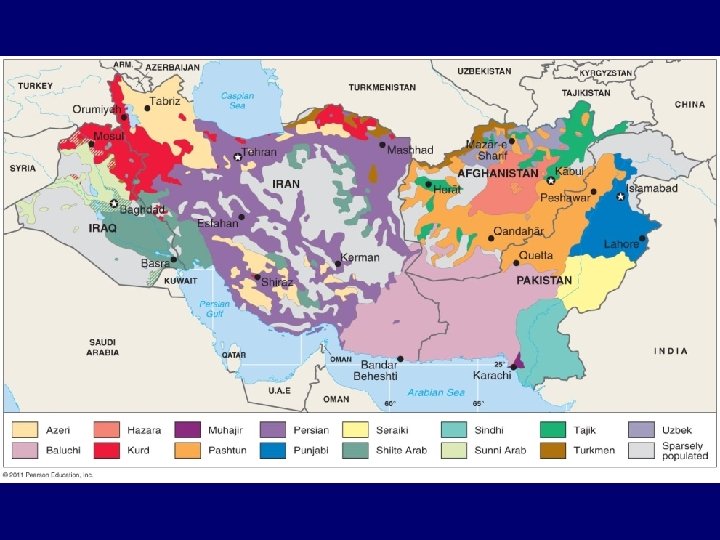
 Distribution of Hmong people
 but") multistate nation: a nation that has its own state (unlike a stateless nation) but also stretches across into another state Examples?
multistate nation: a nation that has its own state (unlike a stateless nation) but also stretches across into another state Examples?
 but") multistate nation: a nation that has its own state (unlike a stateless nation) but also stretches across into another state
multistate nation: a nation that has its own state (unlike a stateless nation) but also stretches across into another state
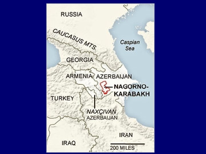
 irredenta: a territory historically or ethnically related to country A but under the political control country B
 irredenta: a territory historically or ethnically related to country A but under the political control country B also: irredentism: the policy of a state wanting to add territory from another state inhabited by people who have cultural links to their own state
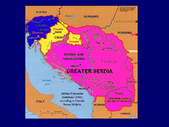
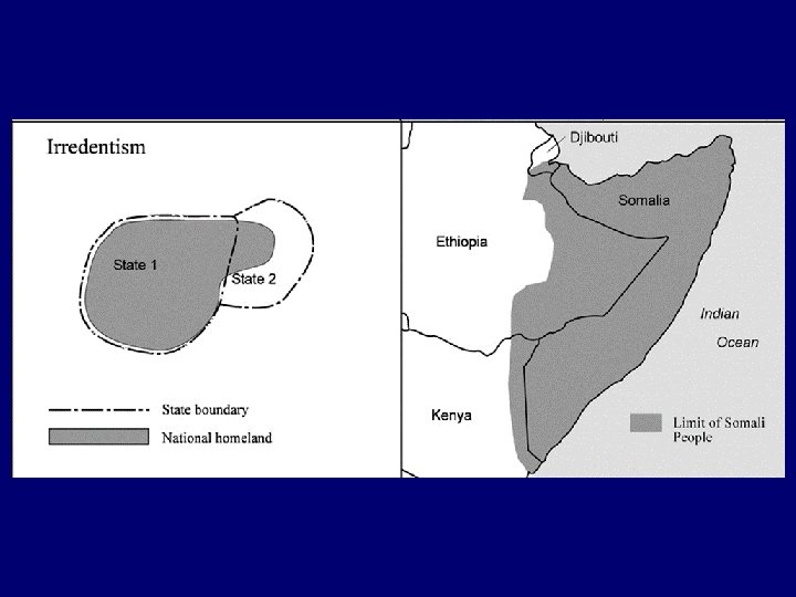
,") When you hear someone make a claim about “Greater ______” (fill in a country), this is a dead giveaway of an irredentist claim. Right: “Greater” Albania (extends into Kosovo, Macedonia, and Greece)
When you hear someone make a claim about “Greater ______” (fill in a country), this is a dead giveaway of an irredentist claim. Right: “Greater” Albania (extends into Kosovo, Macedonia, and Greece)