a5d2f1c02d5ba4013ec6d56ecf59fa82.ppt
- Количество слайдов: 103

United States Global Positioning System (GPS) and Augmentation Systems Update Ad Hoc Provider’s Forum of the International Committee on GNSS Bangalore, India 4 September 2007

Contents Services and Provision Policies Michael Shaw System Descriptions GPS Jules Mc. Neff WAAS/LAAS Carlos Rodriguez Perspective on Compatibility and Interoperability Tom Stansell Spectrum Protection Activities Gene Schlechte David Turner & 2

U. S. Space-Based Positioning, Navigation, and Timing Policy and Program Update Michael Shaw, Director U. S. National Coordination Office for Space-Based Positioning, Navigation, and Timing

Overview • Service Provision Policies • U. S. Law and Policy • Satellite Navigation Trade and Business Practices 4

Introduction • Over the past decade, GPS has grown into a global utility providing space-based positioning, navigation and timing (PNT) – Consistent, predictable, dependable policy and performance – Augmentations improve performance even further • Like the Internet, GPS has become a critical component of the global information infrastructure – Scalable applications enabling broad new capabilities – Facilitating innovations in efficiency, safety, environmental, public security, and science 5

New Applications Are Evolving Every Day • • • Wireless/mobile applications Child/pet tracking Automatic snowplow guidance Spacecraft control Power grid management Open pit mining 6

GPS: Global Public Service • Global GPS civil service performance commitment continuously met/exceeded since 1993 – SPS Performance Standard (2001) • Access to civilian GPS service is free of direct user charges – As well as USG augmentation services (e. g. NDGPS, WAAS, etc. ) • Public domain documentation – Free and equal availability to all users and industry – Equal opportunity to develop user equipment and compete on the world market • Owned and operated by the U. S. Government – Acquired and operated by U. S. Air Force on behalf of USG – Managed at national level as multi-use asset 7

United States Policy History • 1983: President Reagan offers free civilian access to GPS • 1996: President Clinton issues first U. S. GPS policy – Designates GPS a dual-use system under joint civil/military management • 1997: Congress passes law requiring civil GPS to be provided free of direct user fees • 2000: President Clinton sets Selective Availability to “zero” • 2004: President Bush issues U. S. policy on Space-Based PNT 8

U. S. Law – 10 U. S. Code § 2281 The Secretary of Defense: • Shall provide for the sustainment of GPS, and the operation of basic GPS services, that are beneficial for the national security interests of the U. S. • Shall provide for the sustainment and operation of the GPS Standard Positioning Service for peaceful civil, commercial, and scientific uses – Continuous worldwide basis free of direct user fees Policy and Law establish dual-service operation and sustainment of GPS 9

U. S. Policy Promotes Commercial Markets/Applications Growth • Provide civil GPS and augmentations free of direct user fees on a continuous, worldwide basis • Provide open, free access to information needed to use civil GPS and augmentations • Improve performance of GPS and augmentations • Seek to ensure that international space-based PNT systems are interoperable with civil GPS and augmentations or, at a minimum, are compatible Policy stability and transparency improve industry confidence and investment 10

2004 U. S. Space-Based PNT Policy Updated policy retains 1996 principles • Recognizes the changing international scene – Other nations implementing space-based systems that provide PNT services • National Space-Based PNT Executive Committee – Chaired by Deputy Secretaries of Defense and Transportation – Membership includes: State, Commerce, Homeland Security, JCS and NASA • Established National Coordination Office (NCO) a with staff from each member agency 11

U. S. Organizational Structure WHITE HOUSE Defense Transportation State Commerce Homeland Security NATIONAL SPACE-BASED PNT EXECUTIVE COMMITTEE Co-Chairs: Defense, Transportation ADVISORY BOARD Sponsor: NASA Joint Chiefs of Staff NASA COORDINATION OFFICE Host: Commerce 12

National Coordination Office • Facilitates information sharing, coordination, and issue resolution regarding space-based PNT across all Departments • Evaluates plans to modernize U. S. space-based PNT infrastructure • Conducts or oversees space-based PNT studies, analyses, and projects that have broad U. S. Government participation • Represents the Executive Committee in discussion with federal, state, local, and foreign governments 13

National Space-Based PNT Advisory Board • Conducts assessments, makes recommendations to accomplish national policy goals and objectives • Twenty-four members; six international members • First meeting held March 2007 • Next meeting in October 2007 14

U. S. International Cooperation Outlined in 2004 U. S. National Policy on Space-Based Positioning, Navigation, and Timing (PNT) • Provide civil GPS and augmentations free of direct user fees on a continuous, worldwide basis • Seek to ensure international systems are interoperable, or at a minimum, are compatible, with civil GPS and augmentations • Improve performance of civil GPS and augmentations to meet or exceed that of international systems • Provide open, free access to information needed to develop equipment • Encourage international development of PNT systems based on GPS 15

Bilateral GPS Cooperation • U. S. -Japan: Policy and technical consultations on GPS cooperation since 1996 – QZSS augmentation to be compatible, interoperable with GPS • U. S. -EU GPS-Galileo Cooperation Agreement since 2004 – July 2007 accord on improved civil signal (MBOC) • U. S. -India: Policy and technical consultations on GPS cooperation since 2005 – Research into ionospheric distortion/solutions – Joint Statement on GNSS Cooperation, February 2007 • U. S. -Russia negotiating GPS-GLONASS Cooperation Agreement since 2005 – Discussing greater interoperability of civil GPS-GLONASS signals • U. S. -Australia: Joint Delegation Statement on Civil GPS cooperation signed April 2007 – Developing enhanced mechanisms for notification of GPS satellite operational changes 16

Summary • The U. S. supports free access to civilian GNSS signals with public domain documentation necessary to develop user equipment • GPS is a critical component of the global information infrastructure – Compatible with other satellite navigation systems and interoperable at the user level – Guided at a national level as multi-use asset – Acquired and operated by Air Force on behalf of the USG • U. S. Government policy promotes open competition and market growth for commercial GNSS GPS is a Global Public Service providing consistent, predictable, dependable performance 17

The Global Positioning System (GPS) Jules Mc. Neff representing Office of the Assistant Secretary of Defense Networks and Information Integration U. S. Department of Defense

Overview • Global Positioning System Description • System Improvements & Modernization – GPS Constellation Status – Next Steps for Space and Control Segments • System Performance 19

The Global Positioning System • Baseline 24 satellite constellation in medium earth orbit • Global coverage, 24 hours a day, all weather conditions • Satellites broadcast precise time and orbit information on L-band radio frequencies • Two types of signals: – Standard (free of direct user fees) – Precise (U. S. and Allied military) • Three segments: – Space – Ground control – User equipment 20

Overview • Global Positioning System Description • System Improvements & Modernization – GPS Constellation Status – Next Steps for Space and Control Segments • System Performance 21

Current Constellation 30 Operational Satellites (Baseline Constellation: 24) • 15 Block IIA satellites operational • 12 Block IIR satellites operational – 5 remaining Block IIR satellites are modernized • 3 Block IIR-M satellites operational – Transmitting new civil signal (L 2 C) • U. S. Government continuously assessing constellation health to determine launch need – New IIR-M satellites launched • Sep 05, Sep 06, Nov 06 – Next launch: Oct 07 • Global GPS civil service performance commitment met continuously since Dec 2003 22

IIR-15(M) Launch & Aerial View 25 September 2006 23

Overview • Global Positioning System Description • System Improvements & Modernization – GPS Constellation Status – Next Steps for Space and Control Segments • System Performance 24

Modernized GPS – Civil Signals • Second civil signal (“L 2 C”) – Designed to meet commercial needs • Higher accuracy through ionospheric correction • Higher effective power and improved data structure reduce interference, speed up signal acquisition, enable miniaturization of receivers, may enable indoor use – Began with GPS Block IIR-M in Sep 2005; 24 satellites: ~2014 • Third civil signal (“L 5”) – Designed to meet demanding requirements for transportation safety (safety-of-life) • Uses highly protected Aeronautical Radio Navigation Service (ARNS) band – Begins with GPS Block IIF – First launch: ~2008; 24 satellites: ~2016 • Fourth civil signal (“L 1 C”) – Designed with international partners to enable GNSS interoperability – Begins with GPS Block III – First launch: ~2013; 24 satellites: ~2021 25

GPS Modernization – Spectrum P(Y) previous as of Dec 2005 Block IIA, 1990 C/A Block IIR-M, 2005 L 2 C M planned Block IIF, 2008 L 5 L 1 C L 5 ARNS Band L 2 RNSS Band L 1 ARNS Band Block III, 2013 (artist’s concept) 26

GPS Evolutionary “System-of. Systems” Programs Space Segment Modernized (Block IIR-M) Modernized (Block IIF) Legacy (Block IIA/IIR) • 2 nd civil signal (L 2 C) • 3 rd civil signal (L 5) • Std Service (≤ 6 meters • M-Code signals (L 1 M, L 2 M) RMS SIS SPS URE) • Anti-jam flex power • Single frequency (L 1) • Coarse acquisition (C/A) code navigation • Precise Service (≤ 2. 6 m 95% URE PPS at Zero AOD) • Y-Code (L 1 Y & L 2 Y) • Y-Code navigation GPS III (Block III) • Increased accuracy • Increased A/J power • Signal integrity • Search and Rescue • L 1 C civil signal common w/Galileo, QZSS, & possibly GLONASS Ground Segment Legacy • TT&C • L 1 & L 2 monitoring Upgraded (AEP) • IIR-M IIF TT&C • WAGE, AII, LADO • NMCS/AMCS Modernized (OCX V 1) GPS III (OCX V 2) • New Architecture • GPS III TT&C • Signal Monitoring • Real-Time C 2 27

GPS OCS Modernization Status • Transitioning to new ground segment - September 2007 • OCS Modernization impacts every element of OCS architecture • Architecture Evolution Plan (AEP) migrates OCS from mainframe to distributed architecture -- makes OCS easier to operate/maintain – Two new control stations: • New Module at Schriever AFB • New Alternate MCS (AMCS) at VAFB • AEP provides flexibility to incorporate future requirements – Command Control for IIF (1 st launch scheduled for 2008) 28

Modernizing the operational control segment (OCS) • Each SV tracked by three or more monitor stations over 99% of time 29

Overview • Global Positioning System Description • System Improvements & Modernization – GPS Constellation Status – Next Steps for Space and Control Segments • System Performance 30

Constellation Performance January 1 -December 31, 2004 Specification values from the Standard Positioning Service Performance Standard, October, 2001 PDOP (Geometry) Availability Specification - PDOP of 6 or Less, 98% of the time Actual - 99. 98798% Horizontal Service Availability Specification - 95% Threshold of 36 meters, 99% of the Time Actual – 2. 74 meters Vertical Service Availability Specification - 95% Threshold of 77 meters, 99% of the Time or Better Actual – 3. 89 meters User Range Error Specification - 6 meters or Less, Constellation Average Actual – see next chart System accuracy and availability far exceed current specifications 31

GPS constellation – Delivering excellent performance 32

Summary • GPS has been operational and has met its civil service performance commitment continuously since Dec 2003 – Performance continues to exceed standards • GPS modernization is underway – New civil signals being launched – Modernized control capabilities being implemented 33

Wide Area Augmentation System (WAAS) and Local Area Augmentation System (LAAS) Update Carlos Rodriguez, FAA Dr. Navin G. Mathur, AMTI

Agenda • WAAS Architecture • WAAS Ground and Space Segment Update – Phase II – Full LPV Performance (FLP) – Phase III – Full LPV-200 Performance (FLP) – Phase IV – Dual frequency Operations • • WAAS User Segment Update SBAS Interoperability Efforts LAAS Architecture GBAS Activity Update 35

WAAS Architecture 38 Reference 3 Master 4 Signal Generator Stations System/ Ground Earth Stations 2 Geostationary 2 Operational Satellite Links Control Centers 36

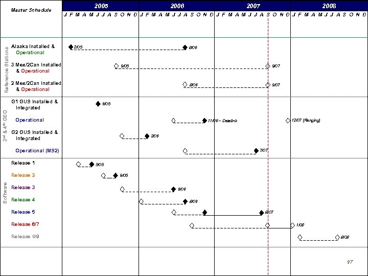
GEO Satellite Improvements • IOC WAAS (Commissioned system) utilized two Inmarsat satellites – Provided single satellite coverage over the majority of the U. S. – Inmarsat satellites removed from operational WAAS July 2007 • Two replacement satellites launched in 2005 • Intelsat (Galaxy XV) Intelsat 133°W Telesat 107°W – Operational November 2006 (Datalink Only) – Ranging scheduled operational mid 2008 • Telesat Canada (Anik F 1 R) – Operational July 2007, for corrections & ranging 37

WAAS Ground and Space segment Update • WAAS Acquisition Phases – WAAS Commissioned – IOC – Phase I 2003 – Full LPV Performance – Phase II 2003 -2008 – Full LPV-200 Performance – Phase III 2009 -2013 – Dual Frequency Operations – Phase IV -2028 2014 • Procedure Development ~300/year 2004 -2028 38

WAAS Program Status – Phase II Full LPV Performance (FLP) • Localizer Performance with Vertical Guidance to 250’ – Provide Full LPV service with a limited LPV-200 approach service availability and coverage within the CONUS – LPV approach service extended to Alaska and portions of Canada and Mexico • Highlights include: – Two new leased GEO satellites that provide the WAAS broadcast SIS, – An additional master station, – Enhancements to the broadcast corrections, and – Additional wide area reference stations (5 Mexico and 4 Canada) 39

WAAS Release 5 40

WAAS Release 6/7 41

WAAS Release 8/9 42

WAAS Vertical Error Performance 43

GPS Performance with WAAS and LAAS GPS Standard Horizontal 95% (Worst Location) Vertical 95% (Worst Location) WAAS LPV LAAS Cat-I Standard Actual 36 meters 1. 08 meters 16 meters 0. 68 meters 77 meters 20 meters 1. 26 meters 4 meters 1. 17 meters WAAS Performance evaluated based on a total of 1, 761 million samples (or 20, 389 user days) LAAS Performance is based on the 104 LAAS approaches at Memphis Airport 44

WAAS LNAV (NPA) Performance 45

WAAS Program Status – Phase III Full LPV-200 Performance • Provides for a robust, reliable, and sustainable LPV-200 capability • Support transition of WAAS maintenance and development capabilities to the FAA • Planned WAAS Algorithm Updates for Phase III – Acquisition of additional GEO satellite – WIPP Participation for continual GIVE Algorithm Tuning (especially during the approaching Solar max) • A contract award for the WAAS Phase III Transition efforts (WAAS Follow-on) is anticipated in Summer 2008 46

WAAS Program Status – Phase IV • Dual Frequency Operations – Maintain a robust, reliable, and sustainable LPV-200 capability • Support Single frequency WAAS users through end of Phase IV (2028) – Support User Equipage of dual frequency (L 1/L 5) avionics • GPS Evolutionary Architecture Study (GEAS) Group formed – Fall 2006 – Goal of GEAS is to identify, evaluate, and recommend GNSS-based architecture (s) for robust LPV-200 service worldwide (circa 2025 -30) 47

WAAS Avionics Status • Total WAAS equipped users ~15, 000 • Approximately 40% of est. 140, 000 GA aircraft are equipped with Garmin receivers – GNS-400/500 series: • 75, 000 non-WAAS capable receivers sold – 18, 000 owners have registered for WAAS upgrade – Plan to upgrade 300 units a month, currently far exceeding that rate » Over 6, 800 units upgraded to date • New production receivers are WAAS capable – 3, 800 units shipped • Rockwell-Collins: Challenger aircraft approval – August 2007 • CMC: FAA contract to integrate CMC WAAS sensor into Honeywell Primus 2000 FMS in FAATC Global 5000 aircraft, expected in 2008 • Universal Avionics: Developing WAAS-enabled capability in dual thread UNS-1 FMS TSO in Summer ’ 07 48

WAAS Procedure Production Type of Approach Procedures To Date Total GNSS Approaches LNAV/VNAV LPV 925 4225 1121 49

SBAS Interoperability Working Group (IWG) • The FAA supports the mission of the IWG –Which is “To perform adequate coordination and cooperation between SBAS Project Offices aiming at ensuring compatibility and interoperability of their respective SBAS Systems over lifetime for the benefit of the SBAS user communities” • The 5 primary objectives of the IWG are: – Objective 1: Harmonize SBAS modernization plans – Objective 2: Forum for discussion on SBAS Technical issues – Objective 3: Harmonize technical improvements from Operation and users feedback – Objective 4: R&D cooperation on key SBAS technologies – Objective 5: Support joint SBAS promotion 50

SBAS Ionospheric Working Group • Chartered under the SBAS IWG to investigate ionospheric issues that jointly affect SBAS providers – FAA has supported the working group for the past 8 years • Collaborated on development of white papers identifying Ionospheric threats • Supported development of ICAO papers on Ionospheric threats • Made available WAAS supertruth data to all participants 51

Local Area Augmentation System (LAAS) Architecture • • Precision approach for Category I, II & III Multiple runway coverage at an airport Guided missed approaches and departure procedures Aircraft surface navigation 52

Current GBAS Activities • Integrity Analysis and Prototype Development – FAA GBAS prototype work under Honeywell Contract – Hazardous Misleading Information (HMI) Analysis underway to validate GBAS architecture/design • GBAS CAT I Approval Process – System Design Approval for Honeywell architecture (SLS 4000)in progress – Hazardous Misleading Information (HMI) Analysis underway to validate GBAS architecture/design • GBAS Avionics – GBAS/LAAS avionics documents (MASPS / MOPS / TSO / SARPS) completed – Boeing 737 -800 series GBAS equipped, Airbus A 320, A 380 certification planned for 2007 (Qantas, Continental, Hapag-Fly aircraft in service and GBAS capable) • CAT-III Research & Development Activities – Continuing Work to Develop Requirements Compatible with Aircraft Operations and Approval Process • International GBAS Cooperation – International GBAS Working Group – FAA Memorandum of Cooperation established with Australia, Brazil, Spain, Germany 53

GBAS - Next Steps • Technical – Continuation of HMI Analysis – Encourage regional investigations of the ionosphere – Encourage rapid transition to ionospheric strategies proposed for GSL-D • Operational – Facility and Service Approval at Memphis in 2008 – Parallel Facility and Service Approval at Sydney International Airport. • International – Coordination of development and approval activities with International community • R&D to Develop and Validate CAT II/III Requirements 54

U. S. Perspective on GNSS Compatibility and Interoperability Tom Stansell representing U. S. Air Force GPS Wing

Definition of Compatibility • “Compatible” refers to the ability of U. S. and foreign space-based positioning, navigation, and timing services to be used separately or together without interfering with each individual service or signal 56

Radio Frequency Compatibility • Ensures that signals do not unacceptably interfere with use of other signals • Requires thorough consideration of detailed technical factors, including – Effects on receiver noise floor – Crosscorrelation between interfering and desired signals • International Telecommunications Union (ITU) provides framework • Details are best worked bilaterally between providers 57

U. S. Objectives in Working with Other GNSS Service Providers • Ensure compatibility – Radio frequency compatibility – Spectral separation between M code and other signals • See following example • Achieve interoperability between GPS civil signals and other system’s civil signals – Primary focus on the common L 1 C and L 5 signals 58

Spectral Separation of GPS Civil and M-code Signals in L 1 M Code signal is spectrally separated from civil signals M Civil Signals 59

Definition of Interoperability “Interoperable” refers to the ability of civil U. S. and foreign space-based positioning, navigation, and timing services to be used together to provide better capabilities at the user level than would be achieved by relying solely on one service or signal Interoperable = Better Together than Separate 60

The Goal of RNSS Civil Interoperability GALILEO QZSS GLONASS GPS • Ideal interoperability allows navigation with one signal each from four different systems with no additional receiver cost or complexity 61

Main Benefit of Interoperability Geometry • More Satellites Better Geometry Improves: – Satellite coverage navigate where could not before – Dilution of Precision accuracy is better everywhere • Eliminates DOP holes (with open sky) – RAIM* integrity checked everywhere, all the time • Eliminates RAIM holes (with open sky) – Phase ambiguity resolution for survey and machine control applications * Receiver Autonomous Integrity Monitoring 62

Important for Interoperability • Common Center Frequency – Like L 5 & E 5 a • Same Antenna Polarization • Common Signal Spectrum Essential (cost driver) Important (no time bias or filter issues) – Identical receiver time delay with common spectrum • Same coherent integration period for acquisition – Usually related to symbol rate – Different symbol rates may require separate search correlators for acquiring signals Desirable (ASIC gate count) 63

US-EU Coordination • 26 June 2004 “U. S. -EU Agreement on GPS-Galileo Cooperation” called for improved compatibility and interoperability between GPS and Galileo • Established bilateral Working Group A (WG-A) on Compatibility and Interoperability – Co-chaired by GPS Wing and European Commission – WG-A meetings: • • • 22– 23 March 2005 in Brussels 14– 15 June 2005 in Los Angeles 20– 21 October 2005 in Rome 20– 21 March 2006 in Stockholm 03– 04 October 2006 in Los Angeles 02– 04 April 2007 in London 64

US-EU Coordination Successes • Managed and agreed GPS-Galileo compatibility – RF compatibility of all signals – Spectral separation of GPS M code and Galileo PRS from each other and from other civil signals • Achieved important levels of interoperability between GPS and Galileo civil signals at L 1 and L 5/E 5 a • Coordinated development of new L 1 civil signals – L 1 C on GPS and L 1 F (OS) on Galileo – New MBOC spreading modulation • Combines BOC(1, 1) and BOC(6, 1) components • Optimized for multipath mitigation and code accuracy 65

US-Japan Coordination • Under the auspices of the 1998 “Joint Statement on Cooperation in the Use of the Global Positioning System” – The US and Japan have held Compatibility and Interoperability Expert Working Group (EWG) meetings on GPS and the Quasi-Zenith Satellite System (QZSS) – Co-chaired by GPS Wing and JAXA – The following meetings have been held: 21– 22 January 2004 in Tokyo 19 November 2004 in Washington 19 July 2005 in Honolulu 06 September 2005 in Tokyo 24 January 2006 in Tokyo 04– 05 April 2006 in Los Angeles 04 August 2006 in Kauai 23 May 2007 in Washington 66

US-Japan Coordination Successes • Agreement on GPS-QZSS compatibility • Achieved important levels of interoperability between GPS and QZSS signals on L 1, L 2, and L 5 – L 1 C, L 2 C, and L 5 QZSS signal specifications derived from and referenced to GPS Interface Specifications 67

US-Russia Coordination • Based on a United States – Russian Federation Joint Statement issued in December of 2004 – A Working Group (WG 1) on GPS-GLONASS Compatibility and Interoperability was formed – Co-chaired by GPS Wing and Roscosmos – The following meetings have been held: • • 5 October 2005 in Moscow, Russia 5 December 05 in Moscow, Russia 7 -8 June 2006 in Cocoa Beach, Florida 13 -14 December 2006 in Yaroslavl, Russia 68

US-Russia Coordination Results • Sharing of system status, concepts, and plans has improved mutual understanding • Compatibility and interoperability of GPS and GLONASS: – Both parties have made “significant progress” understanding benefits to users of a common approach 69

Summary • GNSS compatibility is vital • GNSS interoperability benefits civil users • Bilateral GNSS working groups have been very effective – Both parties benefit from cooperation – Assuring compatibility between systems – Promoting interoperability of civil signals 70

United States GNSS Spectrum Protection Activities David A. Turner Supporting U. S. Department of State

GNSS Spectrum Protection Activities • Domestic RNSS spectrum regulation/management procedures • GNSS Spectrum Concerns • Views on ITU RNSS spectrum issues and WRC Agenda Items 72

Domestic Spectrum Management Process • In the United States, responsibility for spectrum management including frequency allocations is divided between Federal government uses and other uses • The National Telecommunications and Information Administration (NTIA) is responsible for Federal government uses, while the Federal Communications Commission (FCC) for all other uses • Where responsibilities overlap, the FCC and NTIA reach a consensus through coordination 73

NATIONAL Spectrum Management United States SPECTRUM MANAGEMENT COMMUNICATIONS ACT OF 1934 THE PRESIDENT THE CONGRESS NTIA FCC Non-Federal Users National Defense Law Enforce & Security Transportation Resource Mgmt. & Control Emergencies Space Science/Research Other Services COORDINATION Business State & Local Government Entertainment Commercial Private LIAISON ADVISOR INTERDEPARTMENT RADIO ADVISORY COMMITTEE (IRAC) Chaired by NTIA 20 Federal Agencies Represented 3 74

Current GNSS Spectrum Concerns • Ultra-Wideband (UWB) • Mobile Satellite Service Ancillary Terrestrial Component (MSS ATC) • Other potential interference sources • For all three, the concern is In-Band, Spurious, and Out-of-Band Emissions (OOBE) Goal: Protect Sensitive RNSS Bands From Additional Electromagnetic “Noise” To Minimize Radio Frequency Interference (RFI) 75

International RNSS Spectrum Activities (1) • Participation in ITU-R Working Party 8 D – WP 8 D is developing several Recommendations that provide technical characteristics and protection criteria for RNSS systems – WP 8 D is also developing a Recommendation on estimating interference from non-RNSS services to RNSS and a Recommendation on coordination methodology for RNSS inter-system interference estimation – Participation by all system providers is encouraged 76

International RNSS Spectrum Activities (2) • Resolution 609 – The U. S. encourages continued participation in the Resolution 609 Consultation Meetings by all system providers • – • Timely receipt of information to meet the Res 609 deadlines outlined in the Res 609 Terms of Reference is important ITU-R Radio Regulation Article 9 Coordination Requirements – – • Next meeting is scheduled for April/May 2008 Coordination under Article 9 and Resolution 610 is a necessity Coordination can be carried out using the Methodology being developed in Working Party 8 D World Radio-communication Conference 2007 – All parties are encouraged to participate and pursue the protection of GNSS 77
WRC-07 RNSS Goals • WRC Agenda Item 1. 1 - “Deletion of Country Footnotes” ― In order to maintain worldwide radio frequency protections, nations must cease allowing interference sources in the primary GPS/GNSS band (1559 – 1610 MHz). ― In about 40 countries, mainly European, Middle Eastern, and African, GNSS spectrum is also used for fixed links (microwave links) ― At WRC-2000, these nations agreed to remove these fixed links, or use on a non-interfering basis, by 2015 ― The U. S. will continue to encourage countries to adopt spectrum controls in their respective nations to promote safe and reliable GPS/GNSS use worldwide 78

Domestic PNT Interference Detection and Mitigation Gene Schlechte US Coast Guard Navigation Center System Management Division
Presentation Overview • Current GPS Interference Detection and Mitigation Process • Active Television Antenna Example • Interference Detection and Mitigation (IDM) Plan 80
GPS SPS Outage Causes • GPS Constellation anomalies • User equipment anomalies • GPS frequency interference − Intentional − Unintentional 81
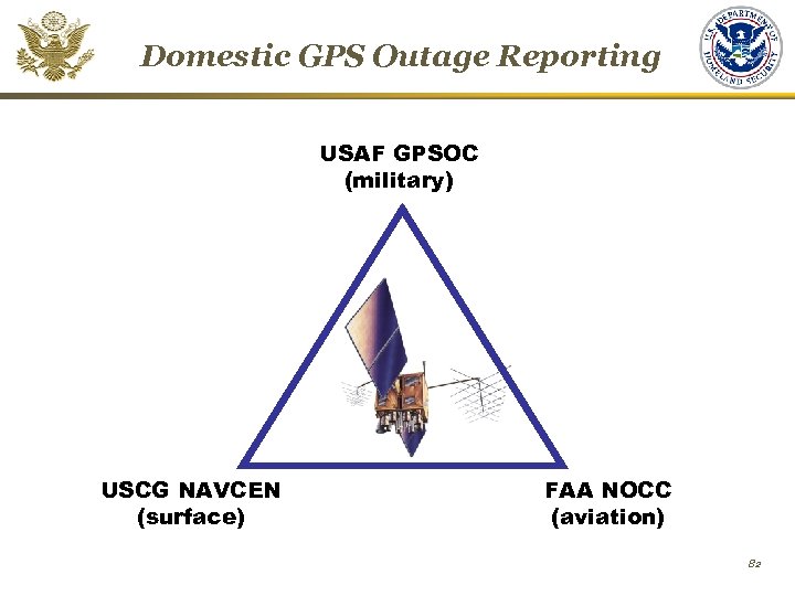
Domestic GPS Outage Reporting USAF GPSOC (military) USCG NAVCEN (surface) FAA NOCC (aviation) 82
GPS Outage Detection • Government managed systems that monitor and/or augment GPS − − − GPS Ground Segment Monitors (USAF) WAAS (FAA) NDGPS (USCG) CORS (NOAA) JPL DGPS Network (NASA) • User Reports (domestic and international) − Web-based − Phone calls − Emails 83
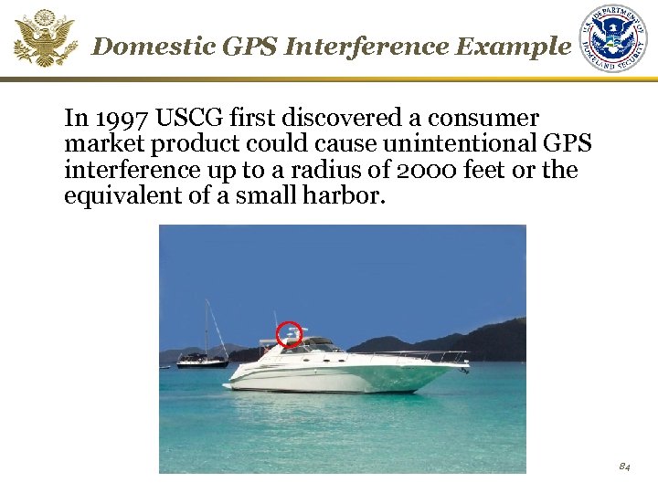
Domestic GPS Interference Example In 1997 USCG first discovered a consumer market product could cause unintentional GPS interference up to a radius of 2000 feet or the equivalent of a small harbor. 84
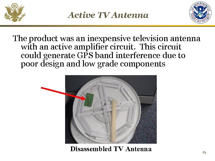
Active TV Antenna The product was an inexpensive television antenna with an active amplifier circuit. This circuit could generate GPS band interference due to poor design and low grade components Disassembled TV Antenna 85
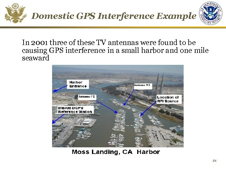
Domestic GPS Interference Example In 2001 three of these TV antennas were found to be causing GPS interference in a small harbor and one mile seaward 86
Interference Mitigation The following mitigation action has been taken for this GPS interference source: • USCG has issued Notice to Mariners and Safety Advisory domestically on this product • FCC has worked with manufacturers to issue voluntary recall of antennas • FCC has stopped domestic production of the antenna’s active circuit card • Characteristics of this interference source can be readily recognized by trained personnel 87
Space-based PNT IDM Plan • Coordinate domestic capabilities to identify, analyze, locate, attribute, and mitigate sources of interference to the GPS and its augmentations • Collect, analyze, store, and disseminate interference reports from all sources to enable appropriate investigation, notification and enforcement action • Develop and maintain capabilities, procedures and techniques, and routinely exercise civil contingency responses to ensure continuity of operations in the event that access to the GPS is disrupted or denied. 88
Space-based PNT IDM Plan Progress • December 2004 - DHS assigned responsibility for domestic PNT IDM planning and coordination • June 2005 – DHS began PNT IDM Plan development starting with existing processes in place for GPS outage reporting, tracking and resolution • October 2006 – PNT IDM Plan completed coordination through the U. S. Space-Based PNT Executive Committee 89
Contents Services and Provision Policies Michael Shaw System Descriptions GPS Jules Mc. Neff WAAS/LAAS Carlos Rodriguez Perspective on Compatibility and Interoperability Tom Stansell Spectrum Protection Activities Gene Schlechte David Turner & 90
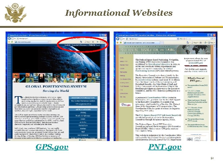
Informational Websites GPS. gov PNT. gov 91
Contact Information Michael E. Shaw Director U. S. National Coordination Office Space-Based PNT 14 th and Constitution Ave, N. W. Washington, D. C. 20230 +1 (202) 482 -5809 Fax: +1 (202) 482 -4429 PNT. Office@PNT. gov for Information available: www. PNT. gov and www. GPS. gov 92

BACK-UP MATERIAL
WAAS/LAAS Update
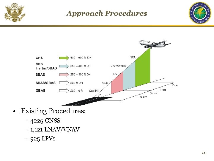
Approach Procedures • Existing Procedures: – 4225 GNSS – 1, 121 LNAV/VNAV – 925 LPVs 95
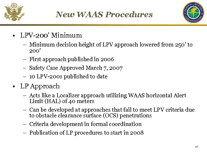
New WAAS Procedures • LPV-200’ Minimum – Minimum decision height of LPV approach lowered from 250’ to 200’ – First approach published in 2006 – Safety Case Approved March 7, 2007 – 10 LPV-200 s published to date • LP Approach – Acts like a Localizer approach utilizing WAAS horizontal Alert Limit (HAL) of 40 meters – Can be developed at approaches that fail to meet LPV criteria due to obstacle clearance surface (OCS) penetrations – Criteria development in formal coordination – Publication of LP procedures to start in 2008 96
3 rd & 4 th GEO Reference Stations Master Schedule Alaska Installed & Operational 2005 2006 2/05 8/06 9/05 9/07 2 Mex/2 Can Installed & Operational 8/06 2/06 Operational (MS 2) Software Release 3 Release 4 Release 5 Release 6/7 Release 8/9 12/07 (Ranging) 11/06 – Datalink G 2 GUS Installed & Integrated Release 2 9/07 6/05 Operational Release 1 2008 J F M A M J J A S O N D 3 Mex/2 Can Installed & Operational G 1 GUS Installed & Integrated 2007 7/07 5/05 9/05 6/06 8/07 1/08 8/08 97
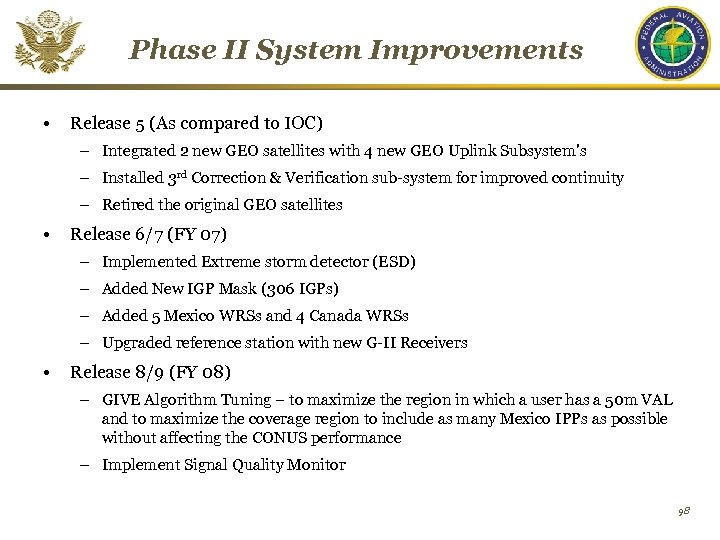
Phase II System Improvements • Release 5 (As compared to IOC) – Integrated 2 new GEO satellites with 4 new GEO Uplink Subsystem's – Installed 3 rd Correction & Verification sub-system for improved continuity – Retired the original GEO satellites • Release 6/7 (FY 07) – Implemented Extreme storm detector (ESD) – Added New IGP Mask (306 IGPs) – Added 5 Mexico WRSs and 4 Canada WRSs – Upgraded reference station with new G-II Receivers • Release 8/9 (FY 08) – GIVE Algorithm Tuning – to maximize the region in which a user has a 50 m VAL and to maximize the coverage region to include as many Mexico IPPs as possible without affecting the CONUS performance – Implement Signal Quality Monitor 98
GNSS Spectrum Protection Activities
NTIA –National Telecommunications and Information Administration • Part of the Department of Commerce • Performs spectrum management and assignment for all Federal spectrum use – Regulations published in Manual of Regulations and Procedures for Federal Radio Frequency Management (NTIA Manual) – Authorized GPS frequency use and coordinates through ITU www. ntia. doc. gov 100
Federal Communications Commission (FCC) • An independent government agency, directly responsible to Congress – Established by the Communications Act of 1934 – Charged with regulating communications by radio, television, wire, satellite and cable • Directed by five Commissioners, appointed by the President and confirmed by the Senate for 5 -year terms • 7 bureaus responsible for: – Processing applications for licenses and other filings – Analyzing complaints and conducting investigations – Developing and implementing regulatory programs • U. S. Table of Allocations for civil and U. S. Government uses is issued by the FCC and is found in the Code of Federal Regulations www. fcc. gov 101
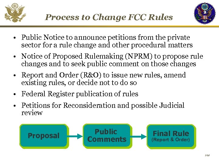
Process to Change FCC Rules • Public Notice to announce petitions from the private sector for a rule change and other procedural matters • Notice of Proposed Rulemaking (NPRM) to propose rule changes and to seek public comment on those changes • Report and Order (R&O) to issue new rules, amend existing rules, or decide not to do so • Federal Register publication of rules • Petitions for Reconsideration and possible Judicial review Proposal Public Comments Final Rule (Report & Order) 102
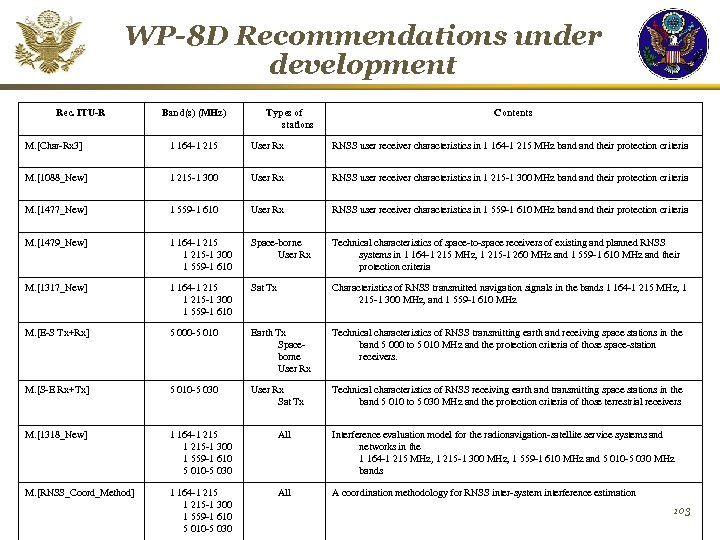
WP-8 D Recommendations under development Rec. ITU-R Band(s) (MHz) Types of stations Contents M. [Char-Rx 3] 1 164‑ 1 215 User Rx RNSS user receiver characteristics in 1 164 -1 215 MHz band their protection criteria M. [1088_New] 1 215‑ 1 300 User Rx RNSS user receiver characteristics in 1 215 -1 300 MHz band their protection criteria M. [1477_New] 1 559‑ 1 610 User Rx RNSS user receiver characteristics in 1 559 -1 610 MHz band their protection criteria M. [1479_New] 1 164‑ 1 215 -1 300 1 559 -1 610 Space-borne User Rx Technical characteristics of space-to-space receivers of existing and planned RNSS systems in 1 164 -1 215 MHz, 1 215 -1 260 MHz and 1 559 -1 610 MHz and their protection criteria M. [1317_New] 1 164‑ 1 215 -1 300 1 559‑ 1 610 Sat Tx Characteristics of RNSS transmitted navigation signals in the bands 1 164 -1 215 MHz, 1 215 -1 300 MHz, and 1 559 -1 610 MHz M. [E-S Tx+Rx] 5 000‑ 5 010 Earth Tx Spaceborne User Rx Technical characteristics of RNSS transmitting earth and receiving space stations in the band 5 000 to 5 010 MHz and the protection criteria of those space-station receivers. M. [S-E Rx+Tx] 5 010‑ 5 030 User Rx Sat Tx Technical characteristics of RNSS receiving earth and transmitting space stations in the band 5 010 to 5 030 MHz and the protection criteria of those terrestrial receivers M. [1318_New] 1 164 -1 215 -1 300 1 559 -1 610 5 010 -5 030 All Interference evaluation model for the radionavigation-satellite service systems and networks in the 1 164 -1 215 MHz, 1 215 -1 300 MHz, 1 559 -1 610 MHz and 5 010 -5 030 MHz bands M. [RNSS_Coord_Method] 1 164 -1 215 -1 300 1 559 -1 610 5 010 -5 030 All A coordination methodology for RNSS inter-system interference estimation 103
a5d2f1c02d5ba4013ec6d56ecf59fa82.ppt