

a165f9b328f94fbad7b721983022d40e.ppt
- Количество слайдов: 31
 Po. DAG XVIII – April 2001") Tools for Working With HDF Data (Especially MODIS) Po. DAG XVIII – April 2001 Terry Haran Siri Jodha Singh Khalsa
Tools for Working With HDF Data (Especially MODIS) Po. DAG XVIII – April 2001 Terry Haran Siri Jodha Singh Khalsa
 The Need Read and extract data out of HDF files MODIS tiles and the ISIN projection Use geolocation info in HDF-EOS files Subsetting, Stitching, and Subsampling Visualization
 NCSA Utilities l l l") Overview of Tools (from presentation to the USWG 11/00) NCSA Utilities l l l HDF dumper can display contents of and extract data from any HDF-EOS file http: //hdf. ncsa. uiuc. edu/hdp. html For example, to extract the snow cover array from a MOD 10 A 1 granule simply type: hdp dumpsds -n Day_Tile_Snow_Cover -b MOD 10 A 1 xyz. HDF > snow. out
Overview of Tools (from presentation to the USWG 11/00) NCSA Utilities l l l HDF dumper can display contents of and extract data from any HDF-EOS file http: //hdf. ncsa. uiuc. edu/hdp. html For example, to extract the snow cover array from a MOD 10 A 1 granule simply type: hdp dumpsds -n Day_Tile_Snow_Cover -b MOD 10 A 1 xyz. HDF > snow. out
 Tool The") Solutions Developed at NSIDC The Polar HDF-EOS Data Imaging and Subsetting (PHDIS) Tool The MODIS Swath-to-Grid Toolbox (MS 2 GT) The MODIS Reprojection Tool l originated with EDC, enhanced by NSIDC
Solutions Developed at NSIDC The Polar HDF-EOS Data Imaging and Subsetting (PHDIS) Tool The MODIS Swath-to-Grid Toolbox (MS 2 GT) The MODIS Reprojection Tool l originated with EDC, enhanced by NSIDC
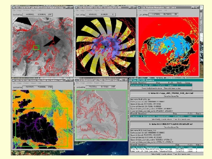
 PHDIS Tool Began as support to the Polar Pathfinder Project l samples of AVHRR, SSM/I and TOVS converted to HDF-EOS Specifically for data in EASE Grid l newest version also reads swath data Visualize and extract data from the same area across multiple data sets
 PHDIS zoom window SSM/I 85 V TB over Hudson Bay. Legend includes: - color bar - thumbnail locator - lat/lon, value under cursor
 One granule of MODIS Level 1 b Band 2 radiance data, displayed with PHDIS. 24 May 2000 All 15 reflective visible bands selectable from pull-down list.
 data Level 1 b radiances l") MS 2 GT Reads MODIS level 2 (swath) data Level 1 b radiances l Level 2 snow and ice products l Outputs binary data arrays selection of projections l can stitch together multiple swaths l In beta testing draft user documentation available l poster at Spring AGU EOS Tools session l
MS 2 GT Reads MODIS level 2 (swath) data Level 1 b radiances l Level 2 snow and ice products l Outputs binary data arrays selection of projections l can stitch together multiple swaths l In beta testing draft user documentation available l poster at Spring AGU EOS Tools session l
 Orbit map on MODIS browse page can be used to select swath segments of interest.
 1 June 2000, 1445 Z 1 June 2000, 1450 Z M O D I S B A N D 1
 Two MODIS swaths stitched together and gridded to EASE grid.
 Due to the “bowtie” effect, images made directly from swath data have a “double vision” appearance away from nadir. The same region after gridding.
 R OU LY AL SE BA NG O EL EB AR TO !!! US MODIS band 1 in a relatively featureless region of the Greenland plateau, showing striping due to detector-to-detector miscalibration.
 Band 2 – 250 m Sea Ice – 1 km land ice cloud open ocean
 for the same swath") land cloud MODIS Ice Surface Temperature (Level 2, not gridded) for the same swath shown in the previous images.
land cloud MODIS Ice Surface Temperature (Level 2, not gridded) for the same swath shown in the previous images.
 MODIS Reprojection Tool Regrids MODIS ISIN tiled data NSIDC enhancement – hdf 2 hdr stitches Nx. M array of tiles together l resultant “super-tile” then used as input l
 The Integerized Sinusoidal Grid The four tiles used in the following example.
 Four tiles individually reprojected into EASE Grid horizontal-9, vertical-4 horizontal-10, vertical-4 horizontal-9, vertical-5 horizontal-10, vertical-5
 A “Super-tile” Reprojected The 4 tiles on the previous figure first combined then reprojected into EASE Grid
 l good support for HDF-EOS files") Commercial Solutions MS Windows only Noesys (from RSI) l good support for HDF-EOS files l lat/lon readout of grid cell subsetting can also create HDF files Windows Image Manager (Wim. Soft) l reads and writes HDF Explorer (Space Research Software) l l reads and write HDF free version available (HDF Inspector)
Commercial Solutions MS Windows only Noesys (from RSI) l good support for HDF-EOS files l lat/lon readout of grid cell subsetting can also create HDF files Windows Image Manager (Wim. Soft) l reads and writes HDF Explorer (Space Research Software) l l reads and write HDF free version available (HDF Inspector)
 Commercial Solutions Multi-Platform IDL l includes HDF browser and HDF-EOS library MATLAB l includes HDF-EOS library ENVI (has free version) PCI-Geo. Gateway (has free version) PV-Wave (HDF read/write)
 Public and Community Solutions Free, Multi-Platform NCSA Tools l l l utilities Java HDF Viewer Scientific Data Browser (used by DIAL) Webwinds ISIS-cv (Cube Visualization) l ISIS is free but cv plug-in requires IDL HDFLook/Msphinx l Unix/Linux only
 DAAC and IT HDF Pages Goddard DAAC HDF page l includes user-contributed software library MODIS Data Tools at GSFC l lists many tools, commercial, public and DAAC-developed MODIS-Atmospheres Tools at GSFC l includes subsetting and visualization tools La. RC DAAC HDF page
 URL’s of Interest NCSA’s list of tools that support HDF l 37 freeware, 18 commercial NASA/ESDIS’ list of HDF-EOS tools l shorter list (source must provide info) NSIDC’s HDF-EOS page l contains links to presentations on HDF and tools for working with it
 The Future – MS 2 GT Enhancements to MS 2 GT Enable IDL to automatically geolocate output l De-stripe Level 1 b radiances l Minimize memory usage l Do inverse navigation l Integrate with PHDIS? l Use GCTP in place of mapx? l Geo. TIFF output for GIS tools l
 The Future - PHDIS Release of PHDIS to public Unveiling at Spring AGU EOS Tools session l Requires users to have IDL l Invest in licenses for distribution? l Additional features/fixes l Perform in-house? Convert heritage data to HDF-EOS?
 The Future - New. DISS Earth-Science Markup Language http: //esml. itsc. uah. edu l Developing a standard description for all aspects of the data, including its format l Allows applications to become independent of format l l Data accessed over the web in a way that makes the format transparent
 Question: Should NSIDC be in the tools business? l to some degree it has been all along Pros: l enhances user support Cons: l development and maintenance costs
 Backup Charts
 mod 02. pl. gl 1_2000153_1445 listfile. txt Gl 1250. gpd chanfile. txt ancifile. txt 3 3 MOD 021 KM. A 2000153. 1445. 002. 2000156075718. hdf MOD 021 KM. A 2000153. 1450. 002. 2000156075717. hdf N 200 correct. mpp 1860 1740 160 1949. 5 -250. 5 output: 12945600 12945600 Apr Apr Apr 19 19 19 map projection parameters columns rows grid cells per map unit map origin column, row 14: 24 14: 25 1 reflectance 2 reflectance 31 temperature 32 temperature seze scaled soze scaled Azimuthal Equal-Area 90. 0 lat 0 lon 0 0. 0 rotation 200. 5402 scale (km/pixel) 90. 00 00. 00 center lat lon 0. 00 90. 00 lat min max -180. 00 lon min max 15. 00 30. 00 grid 0. 00 00. 00 label lat lon 1 0 0 cil bdy riv gl 1_2000153_1445_refa_ch 01_01860_01740. img gl 1_2000153_1445_refa_ch 02_01860_01740. img gl 1_2000153_1445_scaa_seze_01860_01740. img gl 1_2000153_1445_scaa_soze_01860_01740. img gl 1_2000153_1445_tema_ch 31_01860_01740. img gl 1_2000153_1445_tema_ch 32_01860_01740. img