2943ceee4860d655fd09cf72103da3f6.ppt
- Количество слайдов: 44


The Subtropical Sea Breeze John W. Nielsen-Gammon Texas A&M University
 Theory Niino (1987) Theory Reconciling with")
Outline • • • Preconceptions Observations Rotunno (1983) Theory Niino (1987) Theory Reconciling with Observations Modeling Implications
 does the sea breeze attain")
Preconceptions At what time of day (local standard time) does the sea breeze attain maximum strength? 00 LST (midnight) 12 LST (noon) 03 LST 15 LST 06 LST (sunrise) 18 LST (sunset) 09 LST 21 LST Need more info Don’t know

Peak sea breeze: 5 PM Land/Sea Breeze, Israel Coast SEA LAND Source: Newman, 1977, JAS Latitude: 31. 6 N Peak land breeze: 5 AM

Standard Conceptual Model from Hsu 1970 MWR

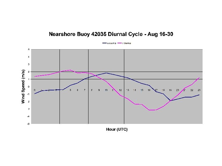
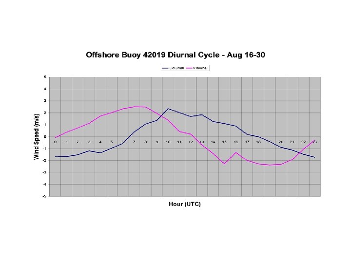
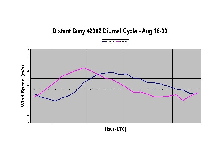
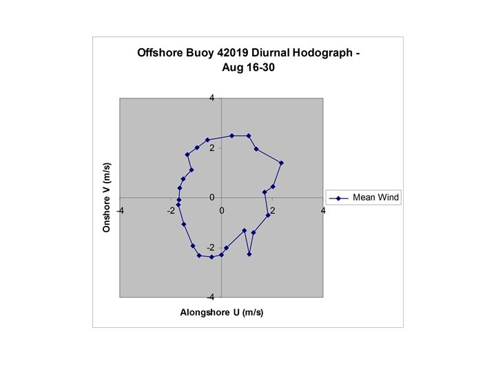
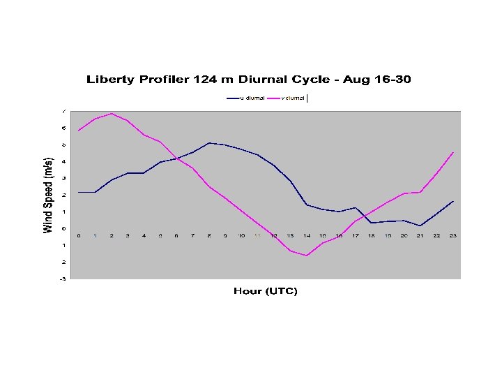
Observations Coordinate definitions: u: along-coast, land to left v: toward land

Surface Stations

SRST 2: C-MAN platform, Sabine, Texas
; u’, v’ (blue, violet): August 2000")
SRST 2 ubar, vbar (yellow, cyan); u’, v’ (blue, violet): August 2000

42002, August 2000

Sea Breeze Sunset Midnight Land Breeze Sunrise Midday Sunset
 • Linear theory • Horizontal scale of sea breeze • Dependence on")
Rotunno (1983) • Linear theory • Horizontal scale of sea breeze • Dependence on f

The Coriolis Force • Caused by Earth’s rotation • Accelerates air parcels to the right (in NH) of their current motion • Force proportional to velocity • If no other forces, parcel will trace a complete circle • Force stronger (& circle faster) at high lats

Equations of Motion Linear, hydrostatic, boussinesq ut – f v = - px + Fx vt + f u = + Fy wt – b = -pz + Fz bt + N 2 w = Q ux + wz = 0

Reduce to one equation for the two-dimensional streamfunction: N 2 yxx + yzztt + f 2 yzz = - Qx Assume e-iwt time dependence: N 2 yxx + (f 2 – w 2) yzz = - Qx
 yzz = - Qx •")
N 2 yxx + (f 2 – w 2) yzz = - Qx • Elliptic if (f 2 – w 2) > 0 – Latitudes greater than 30 o – Solution decays with distance from forcing – Aspect ratio L = NH/ (f 2 – w 2)1/2

Rotunno model: imposed heating -2 0 Sea 2 Land
![Streamfunction at midday: high latitudes [(f 2 – w 2) > 0]](https://present5.com/presentation/2943ceee4860d655fd09cf72103da3f6/image-23.jpg "Streamfunction at midday: high latitudes [(f 2 – w 2) > 0]")
Streamfunction at midday: high latitudes [(f 2 – w 2) > 0]
 yzz = - Qx •")
N 2 yxx + (f 2 – w 2) yzz = - Qx • Hyperbolic (wavelike solutions) if (f 2 – w 2) < 0 – within 30 o of equator
![Streamfunction at dawn: low latitudes [(f 2 – w 2) < 0]](https://present5.com/presentation/2943ceee4860d655fd09cf72103da3f6/image-25.jpg "Streamfunction at dawn: low latitudes [(f 2 – w 2) < 0]")
Streamfunction at dawn: low latitudes [(f 2 – w 2) < 0]
![Streamfunction at midday: low latitudes [(f 2 – w 2) < 0]](https://present5.com/presentation/2943ceee4860d655fd09cf72103da3f6/image-26.jpg "Streamfunction at midday: low latitudes [(f 2 – w 2) < 0]")
Streamfunction at midday: low latitudes [(f 2 – w 2) < 0]
![Streamfunction at sunset: low latitudes [(f 2 – w 2) < 0]](https://present5.com/presentation/2943ceee4860d655fd09cf72103da3f6/image-27.jpg "Streamfunction at sunset: low latitudes [(f 2 – w 2) < 0]")
Streamfunction at sunset: low latitudes [(f 2 – w 2) < 0]

Why the difference? • Role of f as damping at high latitudes • Undamped oscillations at low latitudes
1/2 is normally of order 7 x")
Magic Latitudes • (f 2 – w 2)1/2 is normally of order 7 x 10 -5 • For typical H and N, L = 150 km • At 30+/- 1 degrees, (f 2 – w 2)1/2 is of order 2 x 10 -5 • For typical H and N, L = 500 km

Phase relationships • Inviscid case north of 30: In phase with heating • Inviscid case south of 30: Out of phase with heating • Add viscosity: In quadrature with heating

Phase relationships Time of strongest sea breeze midnight Low sunset midday Hig latit u des s titude h la Increasing friction
 • Heating produced by vertical diffusion • Prandtl number unity • All")
Niino (1987) • Heating produced by vertical diffusion • Prandtl number unity • All vertical diffusion terms remain at leading order • Really ugly equation
 {(d/dt – k d 2/dz 2) * [(d/dt – n d 2/dz")
Niino (1987) {(d/dt – k d 2/dz 2) * [(d/dt – n d 2/dz 2)2 + f 2]} d 2 b/dz 2 + N 2(d/dt – n d 2/dz 2) d 2 b/dx 2 = 0 n=momentum diff. , k = heat diff. (reduces to Rotunno if k = n = 0)
 • Vertical scale: (k/w)1/2 • Horizontal scale: N/w (k/w)1/2 F(f) • F(f)")
Niino (1987) • Vertical scale: (k/w)1/2 • Horizontal scale: N/w (k/w)1/2 F(f) • F(f) ranges from 0. 7 (high latitudes) to 2. 2 (low latitudes)

Niino with friction: maximum onshore wind Equator 30 North High latitude

Niino without friction: maximum onshore wind 0 North 15 North 29. 7 North 50 North
 Theory • Viscosity matters in neutral boundary layer • Viscosity important over")
Compromise (2000) Theory • Viscosity matters in neutral boundary layer • Viscosity important over land, not water • Internal inertia-gravity waves extending to sea • Seaward scale much larger than landward scale

Summary • Observations show sea-breeze-like oscillations extending well into Gulf of Mexico • Observations show wavelike wind oscillations above the boundary layer over land
 • Inviscid theory predicts large horizontal extent near 30 o • Viscous")
Summary (continued) • Inviscid theory predicts large horizontal extent near 30 o • Viscous theory predicts limited (100 km) horizontal extent everywhere • Compromise theory: – Viscous wavemaker over land – Nearly inviscid waves over water

Implications for Atmosphere • Enhanced heat/moisture fluxes over water • Diurnally-dependent transport over Gulf • Layered diurnal dispersion of plumes over land • Away from sea breeze front, “simple” oscillatory behavior

Implications for Air Quality Modeling • Model must resolve freely-propagating waves within and above the boundary layer – Vertical grid spacing? – Horizontal grid boundaries? – Spinup time?

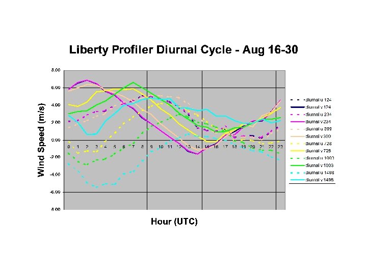
Future Directions • Horizontal structure with profiler data • Time-dependent viscosity over land • Full MM 5 simulation of sea breeze – PBL parameterization? – Vertical resolution? – Role of basin shape?

Acknowledgments • Supported by the state of Texas through the Texas Air Research Center (but what I said is not necessarily what they would say) • Profiler data: Dick Mc. Nider • Buoy data: National Oceanographic and Atmospheric Administration
2943ceee4860d655fd09cf72103da3f6.ppt