

cb61bdb14f62ceb028be4570a6f7dfb3.ppt
- Количество слайдов: 70
 Center for Analysis and Prediction of Storms University") The Advanced Regional Prediction System (ARPS) Center for Analysis and Prediction of Storms University of Oklahoma
The Advanced Regional Prediction System (ARPS) Center for Analysis and Prediction of Storms University of Oklahoma
 ARPS is an n n end-to-end, fully automated,") The Advanced Regional Prediction System (ARPS) ARPS is an n n end-to-end, fully automated, multi-scale, nonhydrostatic atmospheric prediction system
The Advanced Regional Prediction System (ARPS) ARPS is an n n end-to-end, fully automated, multi-scale, nonhydrostatic atmospheric prediction system
 ARPS: The Foundation • Developed from scratch starting in 1992 • Advanced physics and numerical techniques • Designed for all classes of computers, especially MPP (has been run on 1024 node Cray T 3 E, Origin 2000, workstations, PCs, Cray C/J/T-90) • Professionally engineered; consistent design structure; extensive documentation including external user’s guide
 ARPS: The Foundation • Designed to be used operationally; self-contained and globally-relocatable • Email-based user support system • Online documentation (PDF, HTML, text) and FAQ • Tested in real time for many years, and since 1996 has been used on a regular basis experimentally by numerous groups including American Airlines and the National Weather Service • Used for a variety of research applications
 http: //www. caps. ou. edu/ARPS
 ARPS Components
 Uniqueness of ARPS n A system with its own native ingest, analysis, and data retrieval packages n Only system that can assimilate WSR-88 D Level II (base) and III Doppler radar data from multiple radars in real time n A system designed from beginning for all classes of computers n A system that has been run operationally for several years, using full physics and high-resolution observations, at grid spacings down to 3 km n A system designed for commercial and operational use from the very beginning; professional software design/documentation
 Parallel Performance on SGI/Cray Origin 2000
 Parallel Performance on 1328 Node Cray T 3 E-900
 Example Research Applications n Density Current Theories and Simulations
 Simulation of 3 D Density Currents/Gust Fronts Growing Vortices from both Horizontal Shear and Lobe-cleft Instabilities A ‘haboob’ acrossing Melbourne, Australia, 2 Feb. 1983
 Example Research Applications n Simulations of Squall lines
 Example Research Applications n Tornadic Supercell Storm Simulations Column contains high vorticity
 Example Research Applications n Orographic flows and Severe Downslope Wind Storms Air flow trajectory over mountain High surface wind on the lee slope
 ARPS Components
 n Manages the real time ingest, QC, objective analysis") ARPS Data Analysis System (ADAS) n Manages the real time ingest, QC, objective analysis of observations • • n Doppler radar data (NIDS, base Level II from n systems, VAD) MDCRS commercial aircraft wind and temperature reports Wind profilers RAOBS (conventional, CLASS, dropsondes) Mobile and fixed mesonets SAO and METAR observations GOES satellite NCEP gridded model output Based on Bratseth successive correction method • Converges to OI • User specifies number of passes and data used
ARPS Data Analysis System (ADAS) n Manages the real time ingest, QC, objective analysis of observations • • n Doppler radar data (NIDS, base Level II from n systems, VAD) MDCRS commercial aircraft wind and temperature reports Wind profilers RAOBS (conventional, CLASS, dropsondes) Mobile and fixed mesonets SAO and METAR observations GOES satellite NCEP gridded model output Based on Bratseth successive correction method • Converges to OI • User specifies number of passes and data used
 n n n User specifies background error covariances and") ARPS Data Analysis System (ADAS) n n n User specifies background error covariances and structure functions Handles large variety of data formats (GRIB, Net. CDF, ARPS binary, GEMPAK) Performed on flexible native ARPS grid Linked closely with ARPS data assimilation system (via, e. g. , nudging, intermittent assimilation) 3 -D cloud analysis and diabatic initialization package using GOES and NEXRAD data Currently run daily, in real time, over serval regions of the US
ARPS Data Analysis System (ADAS) n n n User specifies background error covariances and structure functions Handles large variety of data formats (GRIB, Net. CDF, ARPS binary, GEMPAK) Performed on flexible native ARPS grid Linked closely with ARPS data assimilation system (via, e. g. , nudging, intermittent assimilation) 3 -D cloud analysis and diabatic initialization package using GOES and NEXRAD data Currently run daily, in real time, over serval regions of the US
") ARPS Data Analysis System (ADAS)
ARPS Data Analysis System (ADAS)
 ADAS Cloud Analysis Scheme GOES Visible Image at 1745 UTC on 07 May 1995
 ADAS Cloud Analysis Scheme Vertical E/W Cross-Section: METAR + GOES IR + WSR-88 D
 ADAS Cloud Analysis Scheme PW and Vertically Integrated Condensate Valid 13 UTC on 12 April 1999 GOES Visible Image Valid 13 UTC on 12 April 1999
 Sample ARPSView Products Cloud Type and LWC at FL 050 Cloud Type and LWC at FL 320 Cloud Type and LWC N/S X-Section
 Sample ARPSView Products Surface Visibility Clear-Air Turbulence Icing Potential
 Sample ARPSView Products Sounding and Hodograph Meteogram
 Sample ARPSView Products Hourly Station Model Plots for 10 Regions in US
 ARPS Components
 n observe. . . • One (radial) wind component •") Single-Doppler Velocity Retrieval (SDVR) n observe. . . • One (radial) wind component • reflectivity n need. . . • • • n 3 wind components temperature humidity pressure water substance (6 -10 fields) SDVR solves the inverse problem • control theory (adjoint), simpler methods • computationally very intensive
Single-Doppler Velocity Retrieval (SDVR) n observe. . . • One (radial) wind component • reflectivity n need. . . • • • n 3 wind components temperature humidity pressure water substance (6 -10 fields) SDVR solves the inverse problem • control theory (adjoint), simpler methods • computationally very intensive
 Shapiro 2 -Scalar SDVR Methodology
 Shapiro 2 -Scalar SDVR Methodology Dual-Doppler SDVR-Retrieved
 Impact of SDVR
 Approval Pending") Real Time Test Bed for Acquiring WSR-88 D Base Data (Project CRAFT) Approval Pending DDC ICT INX AMA TLX KFSM Radars Online LBB FWS
Real Time Test Bed for Acquiring WSR-88 D Base Data (Project CRAFT) Approval Pending DDC ICT INX AMA TLX KFSM Radars Online LBB FWS
 ARPS Components
 ARPS Model n General features • Fully self-contained meso- and storm-scale prediction model • Can be run at any resolution n • • CAPS has run at 10 m to 60 km Fortran 99 from ARPS 5. 0 Extensive in-code documentation External user’s guide (available online) Email-based user support system + online FAQ Code available online (http: //www. caps. ou. edu/ARPS) Entire ARPS system is in the public domain - no restrictions Designed for all architectures n n n MPI for shared and distributed memory parallel computers UNIX workstations Linux and Windows PCs and their clusters
 ARPS Model n Dynamics and Numerics • • Non-hydrostatic Fully compressible Generalized terrain-following vertical coordinate Arakawa C-grid User-defined vertical stretching Polar stereographic, Lambert conformal, Mercator projections 1 -D, 2 -D, 3 -D geometry Split-explicit solution with vertically implicit option n 2 nd and 4 th order quadratically conservative centered differences Zalesak multi-dimensional monotonic FCT advection Multi-dimensional positive definite centered difference (MPDCD) • Initialization n n Horizontally homogeneous (analytic, sounding) 3 -D inhomogeneous
 • Boundary conditions n n Lateral: Options") ARPS Model n Dynamics and Numerics (continued) • Boundary conditions n n Lateral: Options for any combination of periodic, rigid, zerogradient, wave-radiating, externally-forced, user-specified Upper: Options for rigid, zero-gradient, periodic, Klemp-Durran wave radiating, Rayleigh sponge • Other Features n n n Divergence damping Options for some or all Coriolis terms Skamarock adaptive mesh refinement 2 nd and 4 th order spatial computational mixing Physics • SGS Turbulence n Smagorinsky-Lilly, 1. 5 -order TKE, Germano dynamic closure
ARPS Model n Dynamics and Numerics (continued) • Boundary conditions n n Lateral: Options for any combination of periodic, rigid, zerogradient, wave-radiating, externally-forced, user-specified Upper: Options for rigid, zero-gradient, periodic, Klemp-Durran wave radiating, Rayleigh sponge • Other Features n n n Divergence damping Options for some or all Coriolis terms Skamarock adaptive mesh refinement 2 nd and 4 th order spatial computational mixing Physics • SGS Turbulence n Smagorinsky-Lilly, 1. 5 -order TKE, Germano dynamic closure
 Model Equations
 Model Grid
 n Physics ARPS Model • Moist Processes n n Kuo or Kain-Fritsch cumulus parameterization Kessler, Lin-Tao, Schultz NEM grid-scale microphysics (all highly optimized) • Surface and PBL n n n Convective PBL scheme based on TKE formulation Stability-dependent bulk aerodynamic drag for surface heat, momentum, and moisture fluxes 2 -layer diffusive soil model with surface energy budget (multiple soil types in 1 grid cell; API initialization) Full long- and short-wave radiation (NASA code) including cloud interactions, cloud shadowing, and terrain gradient effects 1 km resolution (over US) USDA sfc characteristics data base and pre-processing software; 30 second global terrain database; 3 second for US plus pre-processing software
 ARPS PBL and Land Surface Processes
 Verification of Land-surface, PBL and Radiation models Model Grid
 Verification of Land-surface, PBL and Radiation models
 ARPS Ice Microphysics Processes
 n Operation ARPS Model • Compilation controlled by a single Unix script/makefile n n Platform dependencies handled automatically Optimization options • Parallel execution via MPI and a system-independent translator for DSM and compute clusters • Multiple I/O formats: binary, HDF, Net. CDF, Gr. ADS, GRIB, AVS, Vis 5 D, ASCII, packed binary n Data reader and unpacking programs provided • EXT 2 ARPS reads GRIB and GEMPAK data for initializing using NCEP Eta and RUC models • Full restart capability • Entire ARPS forecast system fully automated via ARPSControl scripts and cron tabs
 ARPS Model n Code Validation • Code validated against analytical solutions (mountain waves, Beltrami flows) and other models • Validation suite shipped with the code • Sample data sets available
 Real Time Testing n Daily operation of experimental forecast models is critical for • involving operational forecasters in R&D • evaluating model performance under all conditions • testing new forecast strategies (e. g. , rapid model updates, forecasts on demand, re-locatable domains) • developing measures of skill and reliability based on a longterm data base of model output • learning how to integrate new forecast information into operational decision making n Over 25 groups around the US are running models in real time in collaboration with NWS Offices or NCEP Centers; few are assimilating observations
 CAPS Spring 1999 Operational Test • ARPS Model • Assimilation of NEXRAD base data + profilers, MDCRS, OK Mesonet, METARS, GOES • 3 km grid spacing • Full model physics • Run on 256 -node massively parallel SGI Origin at NCSA • Real time output on web to NWSFOs, SPC, AWC • Hundreds of products produced each hour
 Current Operational Technology
 Real Time ARPS Forecast
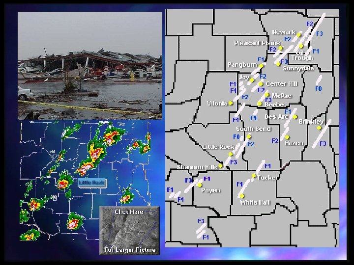
 January 21 -22, 1999 Arkansas Tornado Outbreak 56 tornadoes in the state of Arkansas -around 00 UTC, January 22, 1999 -A historical number of tornadoes in January
 ARPS 12 h forecast on 32 km grid 23: 43 Z, Jan 21
 Sample Operational 32 km ARPS Forecast ARPS 24 -hour, 32 km Resolution Forecast CREF Valid at 12 Z on 1/23/99 National Radar Composite
 Observed ARPS 12 h Forecast on nested 2 km grid
 14: 31 Z Jan 22
 January 22 -23, 1999 Eastern US Squall Line (60 Tornado Outbreaks in Arkansas 36 hours earlier) Radar reflectivity 12: 30 UTC January 23, 1999 (map projection not identifcal). ARPS 48 h Forecast Composite Reflectivity and Mean Sea-level Pressure on 6 km grid
 Vertical Cross-Section
 ARPS Components
 ARPSView Decision Support System n Based on ARPSPlot stand-alone package developed at CAPS • Contours, color shading, 3 -D wire frame, vertical profiles, multiple picture formats, overlays, annotation • Supports X-windows, postscript, GKS n ARPSView • web-based and fully automated • Produces > 2000 products per hour • Animations, meteograms, soundings, diagnostics, custom products n ARPSTools • User-developed toolkit (trajectories, statistics)
 ARPSView Decision Support System Proprietary
 Forecast Status Page
 Near-term Plan of ARPS n ARPS 5. 0 release in 2001 • • • Fully Fortran-90 version New Documentation Many new features now in use will be formally released n n n Advanced numerics Improved ADAS (including cloud analysis) Improved physics (PBL, treatment of soil types)
 Future Plan n A long list – in short • Will emphasize variational data assimilation (3 DVAR first) and soil and precipitation physics improvement • Will continue to improve model numerics • A major initiative is being worked out that will provide ~ million/year for continued model improvement and applications
 • Develop a fully integrated variational data assimilation system with") Future Enhancements (more specifically) • Develop a fully integrated variational data assimilation system with capability of directly assimilating radar and other data types • 3 DVAR is the first step • Will perform research on dynamics constraints and flowdependent error statistics suitable for small-scale nonhydrostatic flows • Two-way interactive nesting on distributed memory computers • Improved numerical schemes (SISL, high-order upwind) • More sophisticated microphysics and soil model • Etc.
Future Enhancements (more specifically) • Develop a fully integrated variational data assimilation system with capability of directly assimilating radar and other data types • 3 DVAR is the first step • Will perform research on dynamics constraints and flowdependent error statistics suitable for small-scale nonhydrostatic flows • Two-way interactive nesting on distributed memory computers • Improved numerical schemes (SISL, high-order upwind) • More sophisticated microphysics and soil model • Etc.
 Features of the ARPS - A detailed List n n n n Computer Language – Pure Fortran-90 starting from Version 5. 0 (beta version is currently available on the web). Documentation - Extensive in-code documentation along with a comprehensive user’s guide. Code Design - Fully self-contained codes that are completely portable among both conventional vector-scalar machines (e. g. , Cray J 90, C 90, T 90, and workstations and PCs) as well as distributed-memory-parallel architectures (e. g. , Origin 2 K, T 3 E, SP 2, PC NT and Linux clusters, distributed homogeneous or heterogeneous clusters) via MPI. The model system is written with a single consistent coding style according to a prespecified standard to ensure readability, maintainability, and ease of modification. Code Structure - The ARPS subroutines are organized by functionality, and the entire software system is divided into sub-directories based on code type and purpose. Availability - All source code and documentation are available via the CAPS web site (http: //www. caps. ou. edu) or an anonymous ftp server (ftp. caps. ou. edu), including PDF and postscript versions of the user’s guide. User Support - An e-mail based user support system (arpssupport@ou. edu) has been in place for several years and continues to be an effective mechanism for dealing with user questions and for reporting bugs in the code. CAPS also maintains ARPS News and ARPS Forum listserver for news announcement and user discussions. Dynamic Framework - Nonhydrostatic and fully compressible with Boussinesq option (for special purposes). Domain Geometry - 1 -D, 2 -D, and 3 -D configurations.
 Features of the ARPS - A detailed List n n n n Coordinate System - Generalized terrain-following coordinate on the Arakawa C-grid with equal-spacing in the horizontal and user-specified stretching in the vertical. Map Projections - Polar stereographic, Lambert Conformal, and Mercator options. Prognostic Variables - Cartesian wind components, perturbation potential temperature and pressure, subgrid-scale turbulent kinetic energy, mixing ratios for water vapor, cloud water, rainwater, cloud ice, snow and graupel/hail. Spatial Discretization - Options for second-order quadratically-conservative, fourth- order quadratically-conservative, Zalesak’s multi-dimensional flux corrected transport (FCT; positive definite), and multidimensional positive definite centered difference (MPDCD) finite difference schemes for advection. Second-order centered differences are used for all other terms. Temporal Discretization - Second-order leapfrog scheme for large time steps with Asselin time filter option. First-order forward-backward explicit with second-order centered implicit option for small (acoustic mode) time steps. Solution Technique - Split-explicit (mode-splitting) with vertically-implicit option. Initial State - Options for horizontally-homogeneous initialization using a single sounding or analytic functions, or a three-dimensional horizontally inhomogeneous state.
 Features of the ARPS - A detailed List n n n n Lateral Boundary Conditions - Options for periodic, rigid, zero-gradient, wave- radiating, externally-forced, and user-specified conditions. All can be mixed and matched. Top & Bottom Boundary Conditions - Options for rigid, zero-gradient, periodic, Durran-Klemp radiation, and Rayleigh sponge layer. Divergence Damping - The model provides an option for divergence damping to control acoustic oscillations. Reference Frame Rotation - Options for inclusion of some or all Coriolis terms. Domain Translation - Options for user-specified or automated (based on feature- tracking algorithms) translation of the computational domain for horizontally homogeneous environments. Adaptive Grid Refinement (AGR) - The Skamarock AGR interface is available on shared memory machines for using unlimited levels of (two-way) grid nesting at arbitrary locations and orientations specified at run time. One-way interactive selfnesting is also available for both shared and distributed memory platforms. Subgrid Scale Turbulence - Options include Smagorinsky-Lilly diagnostic first-order closure, 1. 5 -order turbulent kinetic energy formulation, and Germano dynamic closure. The model also provides options for isotropic and anisotropic turbulence based upon grid aspect ratio.
 Features of the ARPS - A detailed List n n n n Spatial Computational Mixing - 2 nd- and 4 th-order options. PBL Scheme – Non-local PBL turbulence parameterization based on turbulent kinetic energy (TKE) scheme. Cloud Microphysics - Options for Kessler warm-rain, Lin-Tao 3 -category ice, and Schultz simplified ice NEM parameterizations. The Lin-Tao scheme is now almost as computationally efficient as the Schultz scheme due to the use of look-up tables and other optimization strategies. Cumulus Parameterization - Options for Kuo and Kain-Fritsch schemes separately or in combination with other microphysics options. Surface Layer Parameterization - Surface momentum, heat, and moisture fluxes based on bulk aerodynamic drag laws as well as stability-dependent formulations. Soil Model - Two-layer diffusive soil model with surface energy budget equations. Options are provided for multiple soil types in a single grid cell. An API initialization option is also now available. Longwave and Shortwave Radiation - Full long- and short-wave radiation capabilities including cloud interaction, cloud shadowing, and terrain gradient effects. Surface Data - 1 km resolution (over US) USDA surface characteristics database (soil type, seasonal vegetation type and vegetation fraction) and pre-processing software.
 Features of the ARPS - A detailed List n n n Terrain - 5 minute global terrain database, 30 second database for 70% of the earth, and 3 second data for the US. A package is provided for processing these data. Real Data Ingest and Analysis - The ARPS Data Analysis System (ADAS) provides the capability to ingest, quality control, and objectively analyze (using the Bratseth or Barnes schemes) virtually any type of observations including WSR-88 D Level II data. CAPS currently ingests: NIDS data from over 20 WSR-88 D radars; surface and wind profiler observations, rawinsonde observations, Level II data from the Oklahoma City WSR-88 D radar, conventional and Oklahoma Mesonet surface observations, output from several NCEP models, and GOES satellite data. An initial version of ARPS 3 DVAR analysis system has been developed recently. Links to External Models - Using GRIB and GEMPAK readers, the EXT 2 ARPS package allows users to initialize and force the inner domain and lateral boundaries of the ARPS with data from other models including the RUC, Eta and AVN. Data Assimilation - A forward-variational four-dimensional data assimilation system, augmented by a single-Doppler velocity retrieval package, is available. These systems may be used with ARPS or as stand-alone software. Nuding based on analysis increment update (IAU) method is also available. ARPS Adjoint - The adjoint and tangent linear versions of an earlier version of ARPS with warmrain microphysics ARPS are available, with the adjoint including the LBFGS minimization package.
 Features of the ARPS - A detailed List n n n History Dumps - The ARPS supports the following formats: unformatted binary, formatted ASCII, packed binary, NCSA HDF, Net. CDF, packed Net. CDF, Gr. ADS, GRIB, AVS, Savi 3 D, and Vis 5 D. These formats can be read by post-processing programs provided with the model or by user-created programs based on a template provided. Restart Option - Full restart capability is available at intervals selected by the user. Compilation - The compilation of all programs is handled by a single Unix shell script that invokes the Unix make command. Computer system dependencies are automatically handled by the script to facilitate easy migration among platforms and operating systems. Parallel Processor Options - The ARPS utilizes the MPI message-passing libraries for execution on distributed memory computers and clusters. User Interfaces - ARPS and its post-processing packages utilize namelist input files (often shared by several programs) which can be edited manually or configured using ARPSCNTRL perl-based control system. System Automation - The entire forecast system, including data acquisition, quality control, analysis, retrieval, assimilation, forecast model execution, and graphical product generation and display (on the Web) is 100% automated using ARPSCNTL system.
 Features of the ARPS - A detailed List n n Code Validation - A suite of code validation tests is available, ranging from basic advection and symmetry tests to analytic Navier-Stokes solutions and 3 -D storm- and meso-scale simulations. Sample Datasets - CAPS provides a complete horizontally inhomogeneous sample dataset for users interested in exploring the full capabilities of the model. Graphical Post-Processing and Analysis - A vector graphics post-processing package known as ARPSPLT is available for generating color plots, 3 -D wire frames, and profiles of basic and derived fields using model-generated history data. The package supports overlays, color filling, user-specified contour intervals and annotation, and multiple picture formats. It is based on ZXPLOT graphics package whose object library is freely available. Another post-processing package based on NCAR graphics NCL is recently added to the collection of tools. Additional Analysis Tools - A combination of software packages supplied by both local and external users is available in ARPSTools. Capabilities include time-dependent trajectories, thermodynamic diagrams and hodographs, and various statistics.