317a87b40710e053dbf9291f2af41e40.ppt
- Количество слайдов: 21
 TCS-08 Near Real-Time Satellite Field Program Support and Validation [Jeff Hawkins, Kim Richardson, Tom Lee, Buck Sampson, Steve Miller, Arunas Kuciauskas]1, [Chris Velden, Derrick Herndon, Tim Olander, Tony Wimmers]2 Joe Turk 3, and John Kent 4 Organizations: 1 Naval 2 Cooperative Research Laboratory, Monterey, CA Institute for Meteorological Satellite Studies, Madison, WI 3 Jet Propulsion Laboratory, Pasadena, CA 4 Science Applications International Inc, Monterey, CA Sponsors: Office of Naval Research (ONR) SPAWAR PEO C 4 I&Space/PMW-120 Tropical Cyclone Conference May 1, 2009
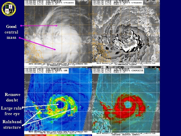 Good central mass Remove doubt Large rainfree eye Rainband structure
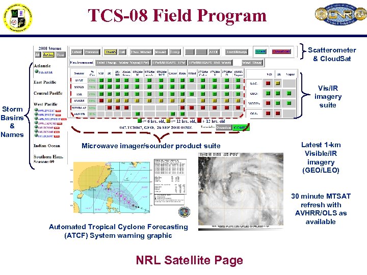 TCS-08 Field Program Scatterometer & Cloud. Sat Vis/IR imagery suite Storm Basins & Names Microwave imager/sounder product suite Automated Tropical Cyclone Forecasting (ATCF) System warning graphic NRL Satellite Page Latest 1 -km Visible/IR imagery (GEO/LEO) 30 minute MTSAT refresh with AVHRR/OLS as available
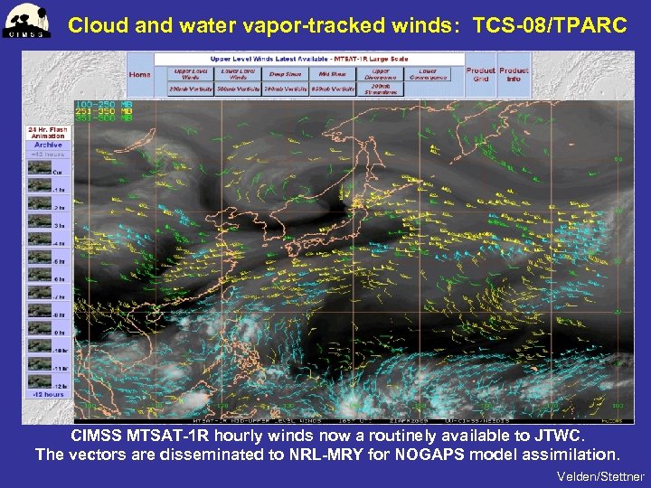 Cloud and water vapor-tracked winds: TCS-08/TPARC CIMSS MTSAT-1 R hourly winds now a routinely available to JTWC. The vectors are disseminated to NRL-MRY for NOGAPS model assimilation. Velden/Stettner
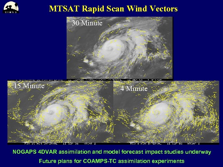 MTSAT Rapid Scan Wind Vectors 30 Minute 15 Minute 4 Minute NOGAPS 4 DVAR assimilation and model forecast impact studies underway Future plans for COAMPS-TC assimilation experiments
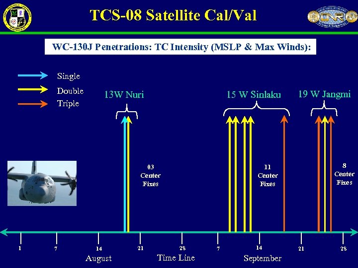 TCS-08 Satellite Cal/Val WC-130 J Penetrations: TC Intensity (MSLP & Max Winds): Single Double Triple 13 W Nuri 15 W Sinlaku 03 Center Fixes 1 7 14 August 21 19 W Jangmi 8 Center Fixes 11 Center Fixes 28 Time Line 7 14 September 21 28
![TCS-08 3 rd flight into the Pre-TY Nuri (13 W) [Harr] Area of ELDORA TCS-08 3 rd flight into the Pre-TY Nuri (13 W) [Harr] Area of ELDORA](https://present5.com/presentation/317a87b40710e053dbf9291f2af41e40/image-7.jpg) TCS-08 3 rd flight into the Pre-TY Nuri (13 W) [Harr] Area of ELDORA radar coverage in the next slide 18 August 2008 NRL P-3 flight track WC-130 J flight track Planned WC-130 flight track Screen capture of realtime display during aircraft operations
TCS-08 3 rd flight into the Pre-TY Nuri (13 W) [Harr] Area of ELDORA radar coverage in the next slide 18 August 2008 NRL P-3 flight track WC-130 J flight track Planned WC-130 flight track Screen capture of realtime display during aircraft operations
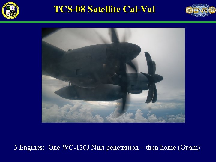 TCS-08 Satellite Cal-Val 3 Engines: One WC-130 J Nuri penetration – then home (Guam)
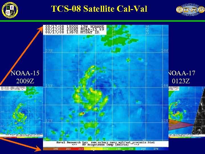 TCS-08 Satellite Cal-Val WC-130 J Vortex Penetration: 13 W Nuri Aug. 17, 2008 2330 Z NOAA-15 2009 Z NOAA-16 2047 Z Met. Op-A 0111 Z AMSU-A/B overpasses: Aug 17 -18, 2008 NOAA-17 0123 Z
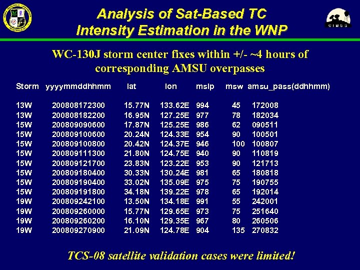 Analysis of Sat-Based TC Intensity Estimation in the WNP WC-130 J storm center fixes within +/- ~4 hours of corresponding AMSU overpasses Storm yyyymmddhhmm 13 W 15 W 15 W 19 W 19 W 200808172300 200808182200 200809090600 200809100800 200809111300 200809121700 200809180400 200809191800 200809242100 200809260000 200809260200 200809270900 lat 15. 77 N 16. 95 N 17. 87 N 20. 24 N 20. 42 N 21. 80 N 23. 83 N 30. 33 N 33. 02 N 34. 18 N 13. 50 N 15. 77 N 16. 10 N 21. 09 N lon 133. 62 E 127. 25 E 125. 25 E 124. 33 E 124. 37 E 124. 75 E 123. 22 E 130. 24 E 135. 09 E 139. 22 E 134. 18 E 129. 65 E 129. 35 E 124. 78 E mslp 994 977 986 954 946 940 953 981 975 978 991 973 967 904 msw amsu_pass(ddhhmm) 45 78 62 90 100 90 90 65 75 65 55 75 80 135 172008 182034 090511 100501 100807 110819 121713 180818 190755 192014 242001 251640 260506 270832 TCS-08 satellite validation cases were limited!
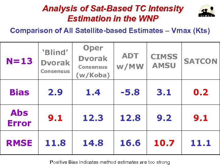 Analysis of Sat-Based TC Intensity Estimation in the WNP Comparison of All Satellite-based Estimates – Vmax (Kts) N=13 ‘Blind’ Dvorak Consensus Oper Dvorak Consensus ADT CIMSS SATCON AMSU w/MW (w/Koba) Bias 2. 9 1. 4 -5. 8 3. 1 0. 2 Abs Error 9. 1 12. 3 12. 8 9. 2 9. 1 RMSE 11. 8 14. 8 16. 6 10. 7 11. 1 Positive Bias indicates method estimates are too strong
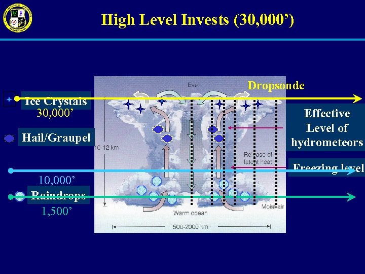 High Level Invests (30, 000’) Dropsonde Ice Crystals 30, 000’ Hail/Graupel 10, 000’ Raindrops 1, 500’ Effective Level of hydrometeors Freezing level
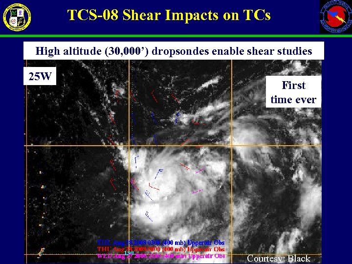 TCS-08 Shear Impacts on TCs High altitude (30, 000’) dropsondes enable shear studies 25 W First time ever Courtesy: Black
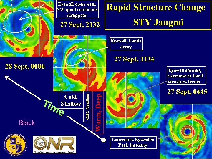 Eyewall open west, NW quad rainbands disappear 27 Sept, 2132 Rapid Structure Change STY Jangmi Eyewall, bands decay 27 Sept, 1134 28 Sept, 0006 e Black 27 Sept, 0445 Warm, Deep Cold, Shallow OHC Gradient Tim Eyewall shrinks, asymmetric band structure forms Concentric Eyewalls: Peak Intensity
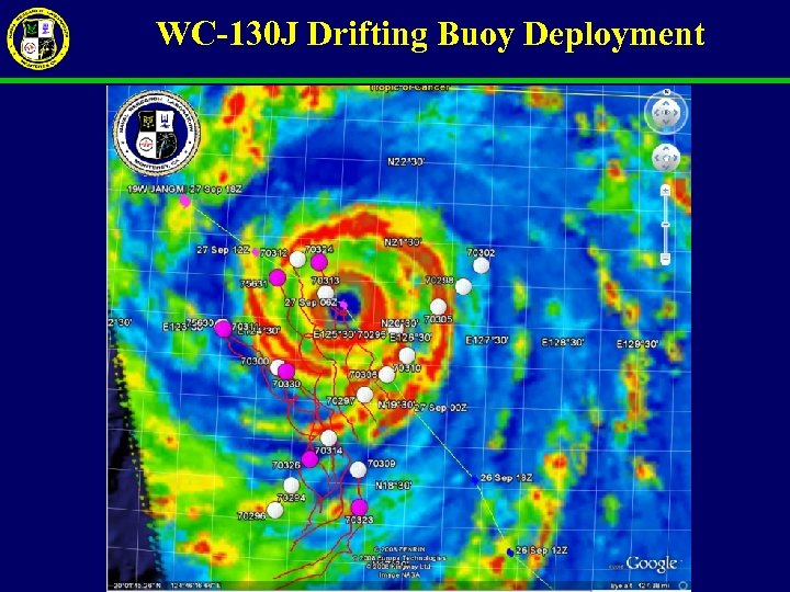 WC-130 J Drifting Buoy Deployment
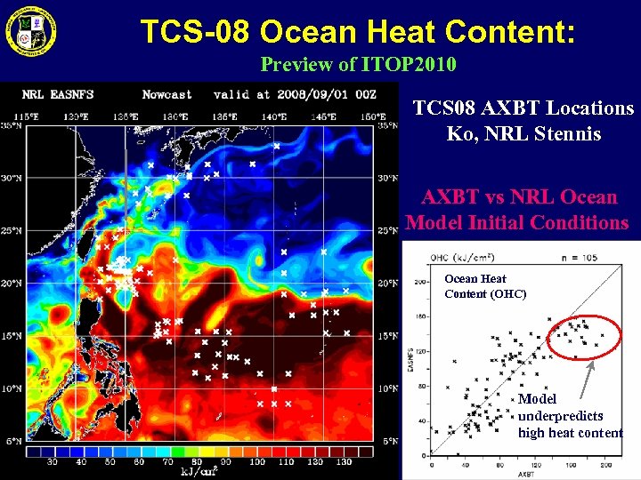 TCS-08 Ocean Heat Content: Preview of ITOP 2010 TCS 08 AXBT Locations Ko, NRL Stennis AXBT vs NRL Ocean Model Initial Conditions Ocean Heat Content (OHC) Model underpredicts high heat content
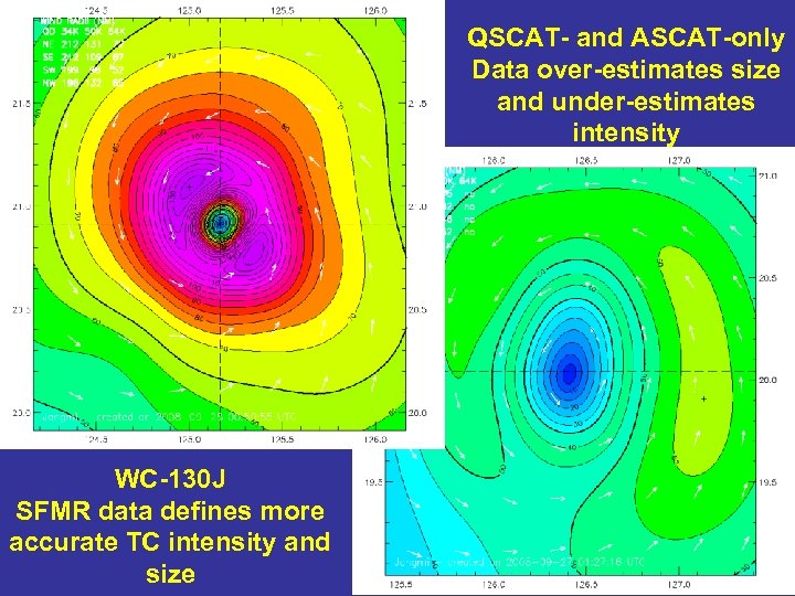 QSCAT- and ASCAT-only Data over-estimates size and under-estimates intensity WC-130 J SFMR data defines more accurate TC intensity and size
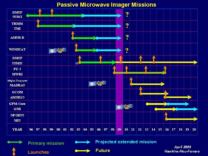 Passive Microwave Imager Missions DMSP SSM/I ? TRMM TMI ? AMSR-E ? WINDSAT ? DMSP SSMIS 16 FY-3 MWRI Megha Tropiques MADRAS GCOM AMSR 2/3 GPM-Core GMI NPOESS MIS YEAR 96 97 98 99 00 01 02 03 04 05 06 07 08 09 10 11 12 13 14 15 16 17 18 19 20 Primary mission Projected extended mission Launches Future April 2009 Hawkins-Hou-Ferraro
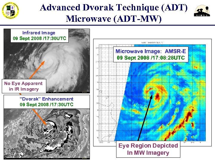 Advanced Dvorak Technique (ADT) Microwave (ADT-MW) Infrared Image 09 Sept 2008 /17: 30 UTC Microwave Image: AMSR-E 09 Sept 2008 /17: 08: 28 UTC No Eye Apparent in IR Imagery “Dvorak” Enhancement 09 Sept 2008 /17: 30 UTC Eye Region Depicted In MW Imagery
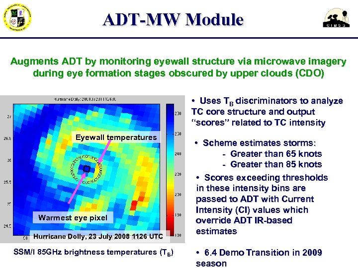 ADT-MW Module Augments ADT by monitoring eyewall structure via microwave imagery during eye formation stages obscured by upper clouds (CDO) • Uses TB discriminators to analyze TC core structure and output “scores” related to TC intensity Eyewall temperatures Warmest eye pixel Hurricane Dolly, 23 July 2008 1126 UTC SSM/I 85 GHz brightness temperatures (TB) • Scheme estimates storms: - Greater than 65 knots - Greater than 85 knots • Scores exceeding thresholds in these intensity bins are passed to ADT with Current Intensity (CI) values which override ADT IR-based estimates • 6. 4 Demo Transition in 2009 season
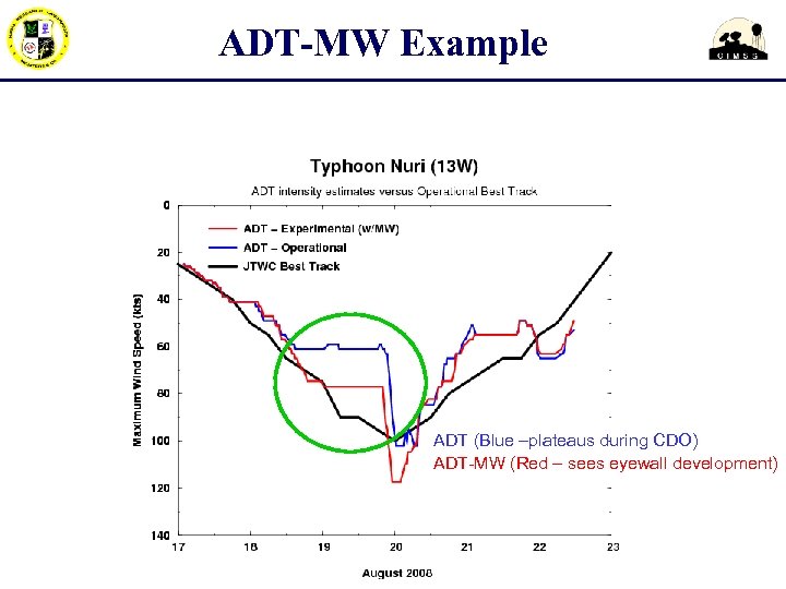 ADT-MW Example ADT (Blue –plateaus during CDO) ADT-MW (Red – sees eyewall development)


