7f375b1643fba00f149404119239dcf7.ppt
- Количество слайдов: 21
 TAOS-RTFS program Hurricane Hazards and Impact Model Disaster Management via Distance Learning Friday July, 16 th 2010
 KAC – TAOS RTFS The TAOS Real-time Impact Forecasting System (RTFS) for the Caribbean Catastrophe Risk Insurance Facility (CCRIF). KAC provides the following map and tabular information for use by CCRIF countries: o maximum expected hazard intensity for wind speed, wave and o o storm surge height, and cumulative rainfall across the entire impact area of the storm; estimates of the impact on the territory by varying hazard levels; estimates of the operational impact of the storm on major ports and airports, and maximum expected hazard values from the current storm as forecast, for up to five user-selected locations. For the maximum wind speed values, the time at which the maximum will occur is also provided.
 New information product For the 2009 season, KAC introduce a new information product that reports the maximum wind, wave and storm surge values that can be expected at a given location during the course of the storm based on the current forecast. Emergency managers can use this information as triggers for preparedness and alert procedures. For example: - Shelter management can be informed of when the maximum wind speed is expected at that location. The decision to evacuate a low-lying area can be informed by the maximum storm surge height expected just off the coast at that location. CIMH is part of the active briefing team at CDEMA and briefs the CDEMA team any time there is an active storm with the potential to threaten one of the CDEMA members (all CCRIF Participants are members of CDEMA).
 Storm Hazard and Basic Impact Results Each hazard and impact forecast file contains three folders, each of which contains multiple map layers: Storm current position and forecast tracks [taos_carib_ofcl_storms_kml] Storm hazard estimates [taos_carib_ofcl_hazards_kml] Territory impact estimates [taos_carib_ofcl_impacts_kml] Ports and airports impact estimates [taos_global_ofcl_transfac_kml] Hazard and impact information is provided for ALL active storms in the Caribbean for which Official forecasts are disseminated by the NHC. Names for individual map layers and folders within these three primary folders identify the map feature and the storm responsible for the hazards and impacts shown.
 Storm ID and layered display KAC uses the unique ID assigned through the Automated Tropical Cyclone Forecasting [ATCF] system to indentify each storm. The ATCFID format ‘ALxxyyyy’, where ‘AL’ denotes the Atlantic basin, ‘xx’ is the sequential number of the storm in the season, and yyyy is 2008, for the 2008 hurricane season. If more than one storm is active in the Caribbean at one time, the separate storm-specific layers allow hazard and impact information for each storm to be displayed separately or simultaneously in the Google Earth.
 Google Earth Platform
 Storm Display
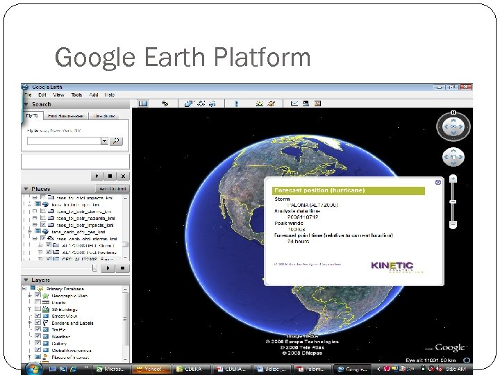
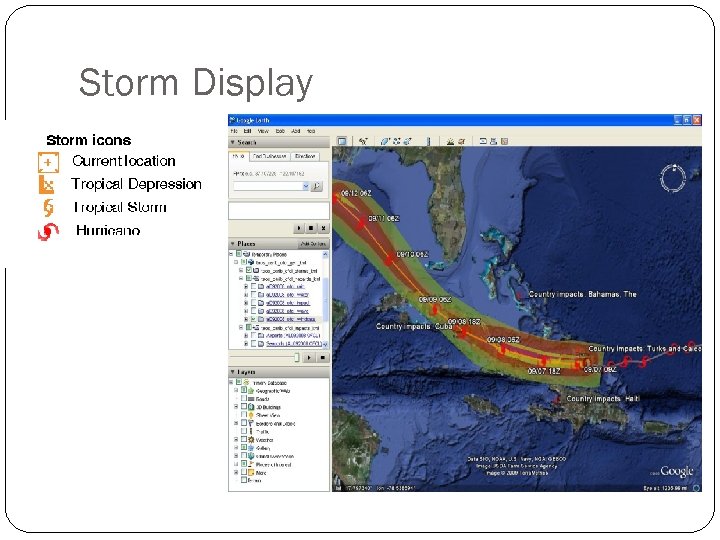
![Storm Position Storm Current Position and Forecast Track [taos_carib_ofcl_storms_kml] This folder contains three subfolders Storm Position Storm Current Position and Forecast Track [taos_carib_ofcl_storms_kml] This folder contains three subfolders](https://present5.com/presentation/7f375b1643fba00f149404119239dcf7/image-8.jpg) Storm Position Storm Current Position and Forecast Track [taos_carib_ofcl_storms_kml] This folder contains three subfolders for each active storm: Official track —the storm track as forecasted by the NHC. The current position of the storm is marked by the hurricane icon. Descriptive balloon - Storm information: - the storm name, date and time, wind speed and central pressure Past positions —locations occupied by the storm center for each of the past forecast times. Forecast positions —future positions as forecasted. Descriptive balloon - each position provides forecast details, including the date and time of the forecast, the expected storm wind speed, and the hours out from current location.
Storm Position Storm Current Position and Forecast Track [taos_carib_ofcl_storms_kml] This folder contains three subfolders for each active storm: Official track —the storm track as forecasted by the NHC. The current position of the storm is marked by the hurricane icon. Descriptive balloon - Storm information: - the storm name, date and time, wind speed and central pressure Past positions —locations occupied by the storm center for each of the past forecast times. Forecast positions —future positions as forecasted. Descriptive balloon - each position provides forecast details, including the date and time of the forecast, the expected storm wind speed, and the hours out from current location.
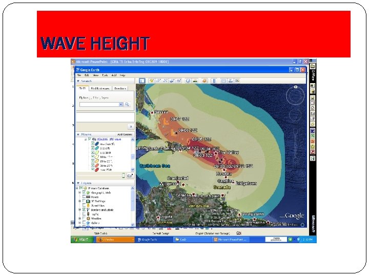
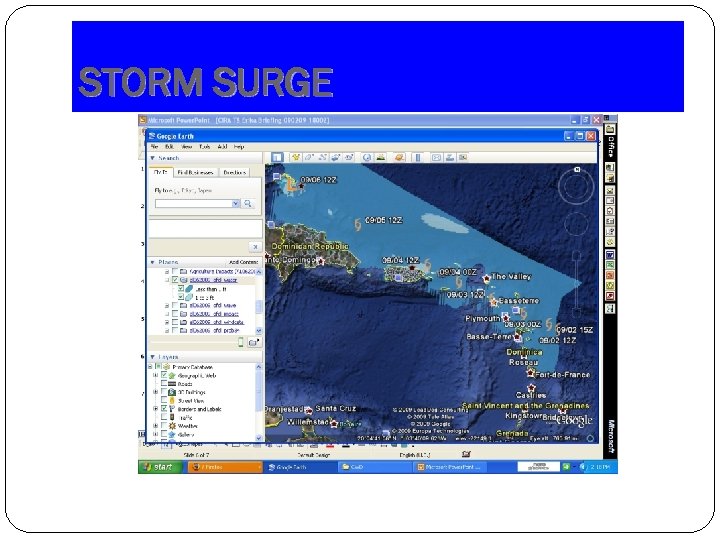
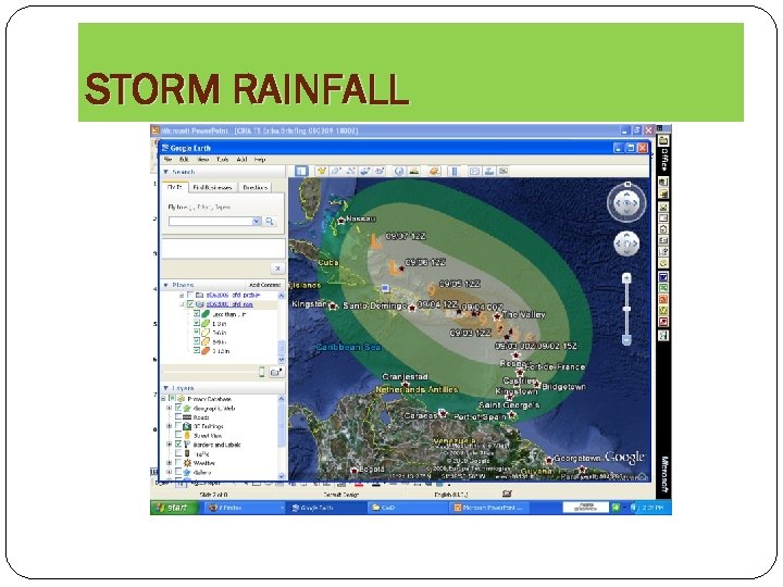
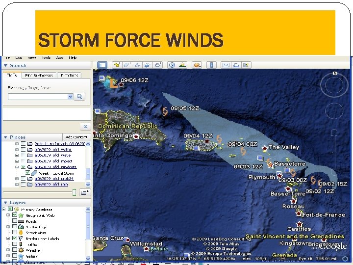
![Hazard Layers Hazard layers [taos_carib_ofcl_hazards_kml] folder Contains four subfolders for each active storm. Hazard Hazard Layers Hazard layers [taos_carib_ofcl_hazards_kml] folder Contains four subfolders for each active storm. Hazard](https://present5.com/presentation/7f375b1643fba00f149404119239dcf7/image-9.jpg) Hazard Layers Hazard layers [taos_carib_ofcl_hazards_kml] folder Contains four subfolders for each active storm. Hazard definitions are provided in the annex. Wind speed [ATCFID*_ofcl_windcats]—maximum wind speed, grouped by Saffir-Simpson category. Storm surge [ATCFID_ofcl_water]—maximum storm surge height; over water, this height is measured above Mean Sea Level and over land it is measured above the terrain height. Wave height [ATCFID_ofcl_wave]—maximum wave height, measured crest-to-trough. Total rainfall [ATCFID_ofcl_rain]—cumulative rainfall over the duration of the storm forecast, since the first forecast for this storm. Impact of wind forces [ATCFID_ofcl_impact]—qualitative wind effects, based on the Beaufort scale Note that the maximum hazard intensities shown in one map layer do not occur simultaneously; they are attained at different times during the progress of the storm along the track. *Automated Tropical Cyclone Forecasting [ATCF] system.
Hazard Layers Hazard layers [taos_carib_ofcl_hazards_kml] folder Contains four subfolders for each active storm. Hazard definitions are provided in the annex. Wind speed [ATCFID*_ofcl_windcats]—maximum wind speed, grouped by Saffir-Simpson category. Storm surge [ATCFID_ofcl_water]—maximum storm surge height; over water, this height is measured above Mean Sea Level and over land it is measured above the terrain height. Wave height [ATCFID_ofcl_wave]—maximum wave height, measured crest-to-trough. Total rainfall [ATCFID_ofcl_rain]—cumulative rainfall over the duration of the storm forecast, since the first forecast for this storm. Impact of wind forces [ATCFID_ofcl_impact]—qualitative wind effects, based on the Beaufort scale Note that the maximum hazard intensities shown in one map layer do not occur simultaneously; they are attained at different times during the progress of the storm along the track. *Automated Tropical Cyclone Forecasting [ATCF] system.
 WAVE HEIGHT
 STORM SURGE
 STORM RAINFALL
 STORM FORCE WINDS
 Impact estimates IMPACTS folder contains four subfolders for each active storm: Impact on Port and Airport facilities[taos_carib_ofcl_tr ansfac_kml]— disruption of operation and potential damage to ports and airports
 TAOS-RTFS Hazard Definitions Wind speed: two-minute average wind speed at 10 m above terrain. These wind speed estimates are compatible with the Automated Surface Observing System (ASOS). Wave height: measured from crest to trough. Storm surge: elevation above mean sea level or terrain height. Surge height includes astronomical tides, windsetup, pressure setup and wave setup, but not wave runup.
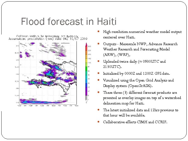 Flood forecast in Haiti High resolution numerical weather model output centered over Haiti. Outputs - Mesoscale NWP, Advance Research Weather Research and Forecasting Model (ARW), (WRF), Uploaded twice daily (≈ 0930 UTC and 2130 UTC). Initialized by 0000 Z and 1200 Z GFS data. Visualized using the Open Grid Analysis and Display system (Open. Gr. ADS). These three (3) different forecast products are prsented as overlay images on top of a watershed delineation map for Haiti. The latest initialized data and 12 hrs previous to that hour will be available. Collaborative efforts CIMH and CCRIF.
 Hurricane IKE August 29 - IKE began as a Tropical Wave off the Cape Verde Islands; September 01 - Developed into Tropical depression 9 and six hour later TS IKE; September 03 - TS IKE became a hurricane centred about 600 n mi east-northeast of the northern Leeward islands; September 04 - Rapid intensification ties Ike with four other Atlantic tropical cyclones for the fifth- fastest intensification rate over a 6 -hour period. September 06 - East of the Turks and Caicos wavered in intensity but matured to a Category 4 storm; September 07 - the northern eyewall passed directly over Grand Turk, Salt Cay, South Caicos, and a few other smaller cays;
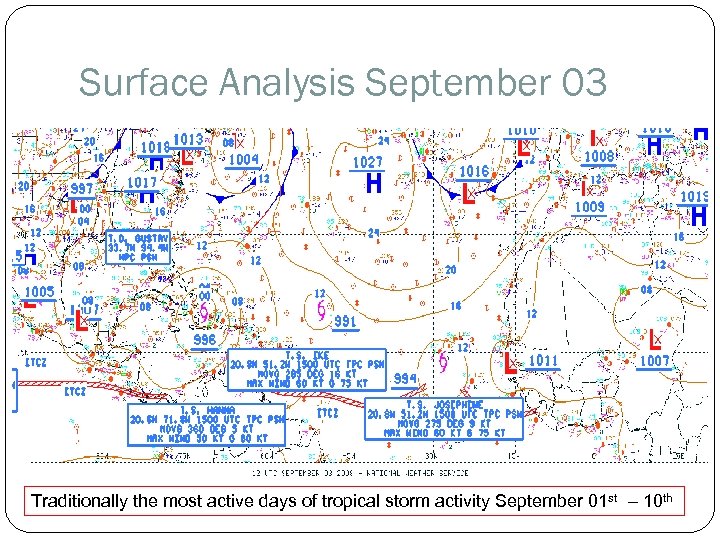 Surface Analysis September 03 Traditionally the most active days of tropical storm activity September 01 st – 10 th
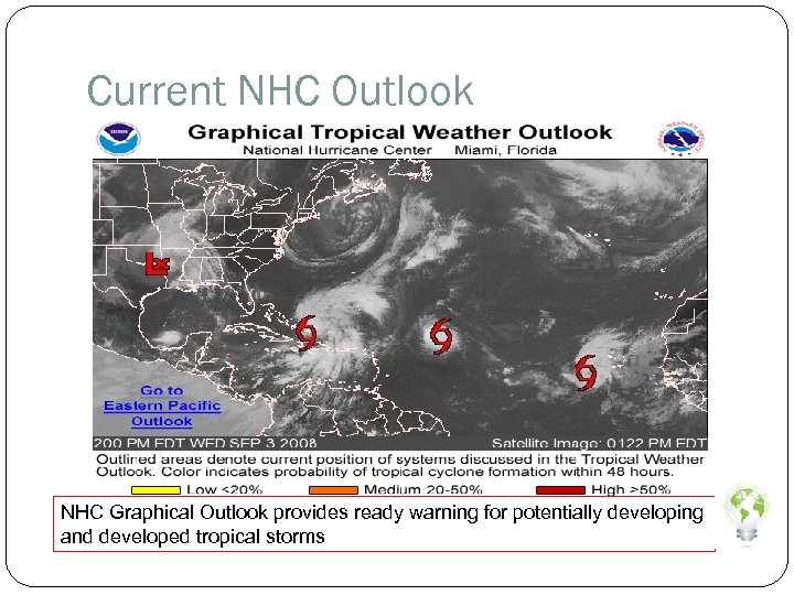 Current NHC Outlook NHC Graphical Outlook provides ready warning for potentially developing and developed tropical storms
 Disclaimer CCRIF distributes the TAOS RTFS data files "as is" and without warranties as to performance or any other warranties whether expressed or implied. The user is strongly cautioned to recognize that natural hazards modeling and analysis are subject to many uncertainties. These uncertainties include, but are not limited to, the uncertainties inherent in weather and climate, incomplete or inaccurate weather data, changes to the natural and built environment, limited historical records, and limitations in the state of the art of modeling, as well as limits to the scientific understanding of some of the phenomena. Anyone making use of the hazard and impact information provided by CCRIF, or the information contained within, assumes all liability deriving from such use, and agrees to "hold harmless" any and all agencies or individuals associated with its creation. The user agrees to provide any subsequent users of this data with this disclaimer. The publication of the material contained herein is not intended as a representation or warranty that this information is suitable for any general or particular use. The CCRIF and KAC, and any other subcontractor or agency or individual associated with the creation or presentation of this data assume no liability connected with your use of the data or the information it contains, and make no warranties, express or implied, as to its usability or accuracy. CCRIF reserves the right at any time to modify or discontinue—temporarily or permanently—the distribution of TAOS-RTFS data files (or any part thereof) with due notice to the participating CCRIF countries.
 Declaimer CIMH is providing special weather interpretation of the current and forecasted tropical weather affecting the Caribbean region. CIMH is not an official forecasting agency


