

5c0fe3ebd5c5fde1929e5f6b5863f58f.ppt
- Количество слайдов: 141
 Study on the ecological quality of the Axios river www. corinthia-net. gr/ecology/axios. htm
 THE TEAM Introduction: Phillip Buckley and Eva Mourgi Materials and Methods: Janina Welsch and Frederic Mineur Evzoni: Sabina-Raluca Datcu and Joan Oudry Axioupoli: Vasilis Dakos, Lina Tzimiri and Danai Paleologou Gorgopi: Alexander Dzubaj and Markos Sarris Katanti: Silvia Markova Overview: Silvia Markova, Phillip Rogers and George-Dragos Zaharescu Statistics: Christos Koukoumidis and Simon Burandt Discussion: Giorgos Anasontzis, Thibault Vannier and Vasilis Dakos Management: Fotis Sgouridis
 CONTENTS Slide number 4 - 12: Introduction 13 - 22: Materials and Methods 23 - 89: Results 90 - 91: Orders and families in each station 92 - 94: Comparison between the water quality of the stations in 1997 and 2000 95 - 110: Overview 111 - 119: Statistics 120 - 134: Discussion 135 - 137: Managerial Proposals 138 - 140: Bibliography 141: Acknowledgements
 Introduction Many of the streams and rivers in the European Union suffer from the anthropogenic effects of abstraction and pollution. Many countries of the EU employ specialized organizations to undertake regular monitoring of running waters (e. g. the Environment Agency in the U. K. ). Greece is one of the EU countries that does not have a national or regional monitoring network (Lazaridou et al. 2000). In the present study an attempt was made to estimate the water quality of the Axios river. This was done using benthic macro-invertebrate samples, physicochemical variables, a vegetation survey and a river habitat survey. This river was chosen because in addition to the natural variation found between upland lowland river sites there were obvious areas of interference by man. http: //www. fourmilab. ch/cgi-bin/uncgi/Earth? i mgsize=320&opt=-z&lat=37. 9667&ns=North& lon=336. 267&ew=West&alt=29&daynight=-d& img=learth. evif
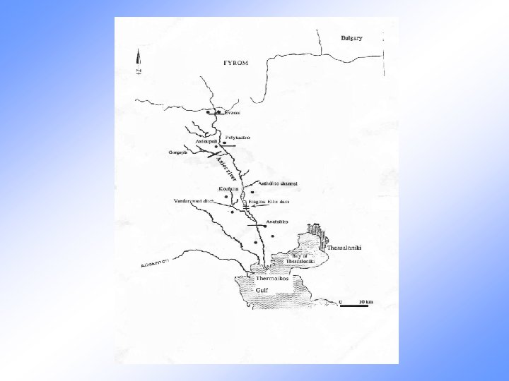
 Study Area General Description The Axios River has its source in the Sar mountains in the Former Yugoslavian Republic of Macedonia (FYROM). The river runs for 320 km, of which 240 km are in FYROM. The remaining 80 km of the river run through Greek territory. Most of the water in the river is drained from FYROM, with only 5% of the water introduced to the river coming from Greece (Argiropoulos, 1991). The river flows south-east, entering Greek territory through a gently undulating plain and discharging into the sea at the Thermaikos Gulf. The Axios estuary, with the estuaries of the rivers Aliakmon and Loudias create a wetland of great importance. This wetland is protected under both the RAMSAR convention (1971), and the “Natura 2000” directive of the European Union (Lazaridou, 1998).
 Land Uses The Greek part of Axios river system can be divided into three regions according to the human activity on the land through which it flows. § The first 20 km of the river in Greek territory, from the border to Polikastro is primarily used for drinking. 1 Fragma Ellis dam 2 3 § The second region which extends from the city of Axioupoli to the demarcation line between the cities of Kilkis and Thessaloniki is used for agricultural irrigation. § The final region leading to the Gulf is mainly utilized for industrial purposes (Agiropoulos 1991, Pitsavas and Ganidou, 1996). http: //egnatia. ee. auth. gr/~akalatha/thmap. htm
 • The main channel is obstructed by the Fragma Ellis dam, 40 km downstream of the border, next to the town of Koufalia. This dam provides water to an extensive network of irrigation channels from May to September (Argiropoulos, 1991). • In addition to removal of water from the river there is also extensive abstraction of sand. The river deposits annually approximately 3. 500. 000 m 3 of sand, this extends the delta into the sea at a rate of 30 m annually (Argiropoulos, 1991). • In the agricultural land that borders the river several different crops are grown: 28. 4% of the land is used for cotton, 22. 2% for corn, 21. 3% is given over to orchards, 12. 3% is used for rice, 3. 6% for tobacco, and 12. 2% for other vegetables (Albanis et al 1994). This places a heavy abstraction strain on the river.
 Sources of Pollution The Axios river accepts waste from Polikastro, Axioupoli and Koufalia. These are the largest urban centres in the region. Polikastro and Axioupoli are also the industrial centres for the area. Several tributaries of the river also introduce pollution. Approximately 2 km above the Fragma Ellis dam, the Anthofito channel deposits municipal and industrial effluent into the main channel (Lazaridou, 1998). The Vardarovasi ditch takes effluent from Koufalia. Agricultural waste is also introduced to the river both through drainage channels and contaminated ground water. The main sources of pollution are shown in the following table (Lazaridou, 1998):
 Table: Main sources of pollution
 Sampling stations The sample sites were chosen according to the physical characteristics, land use and accessibility. Four sites were sampled over the course of one day. q. The first site was approximately 1 km below the border with FYROM, near the village of Evzoni. The sample area was adjacent to agricultural land characterized by low vegetation. The site was not significantly influenced by anthropogenic activities in Greek territory and was chosen to demonstrate the quality of the water coming from FYROM. q. The second station was located 20 km from the Greek border, near Axioupoli. Three samples were taken from this site. One sample was taken from a channel (canal in) leading into the main channel. 50 m above this sample site the channel accepted the effluent from an abattoir. The second sample was taken from the main channel (main flow) immediately upstream of a mature island, just above the entrance of the channel. The third sample was taken from the outflow of the same channel (canal out). Station two was chosen because it examined the first major pollution occurrence in Greek territory. (Lazaridou 1998) Sand was also removed from the river at this site.
 q The third station was located on the Gorgopi river, a tributary that runs into the main channel 25 km from the border. This station was characterized by rich bank side vegetation, small width and depth and high flow. The tributary is thought to accept some agricultural waste from nearby land, but is not heavily polluted by runoff from the land (Lazaridou, 1998). Four samples were taken at this site. The first sample was taken 10 m down stream of a weir and 20 m downstream of a bridge (downstream) The second sample was taken just above the bridge and just below a side channel (middle). The third sample was taken just above this source (upstream). A final sample was taken in a side channel (side channel). This site was chosen to examine the quality of the water that comes from the Gorgopi river to the Axios river. q The fourth station was located near the village of Anatoliko, 1 km from the point were the Vardarovasi ditch discharges into the Axios river, and approximately 64 km from the border. This site was characterized by thick, low vegetation. One sample was taken from this site. The site was chosen because it is located below both the third main source of pollution, the Vardarovasi ditch and the Fragma Ellis dam.
 Materials and Methods Sampling of Macroinvertebrates The first three sites were sampled using a 3 -minute kick-sweep method (Armitage et al. , 1983) with a standard pond net (surface 575 cm 2, mesh size 90 μm, depth 27, 5 cm). During these three minutes all kinds of substrate habitats were sampled. For special habitats like big stones, tree roots or wooden debris a supplementary 1 -minute sampling (by hand) was carried out, according to the relative frequency of these habitats. At Katanti – Anatoliko, due to the depth, a 3 -minute sample was taken standing on the riverbank. A standard pond net was used for agitating the ground while it was pulled towards the bank.
 3 minute kick-sweep method Photo: Maria Lazaridou
 The samples were stored in plastic bottles and fixed in 4% formaline. In the laboratory the samples were washed using a 50 μm mesh sieve and then sorted with the aid of magnifying lenses. All invertebrates were identified to the family level using a stereoscope. They were preserved in ethanol.
 Physicochemical parameters The following physicochemical parameters were measured in situ using a digital multimeter: temperature, total dissolved solids (TDS), p. H and dissolved oxygen (DO 2). Relative abundance of each category of substrate (boulders, cobbles, pebbles, gravel, sand, silt, clay) was estimated visually according to the Wentworth scale. Water velocity was measured at the sampling stations using a flow meter. Discharge was calculated using measurement of velocity and depth at each tenth of the width of the river.
 Physicochemical analysis Photo: Maria Lazaridou
, CANOCO (Ter Braak 1988)") Statistical analysis Three multivariate analyses known as FUZZY (Equihua, 1990), CANOCO (Ter Braak 1988) and PRIMER (Field 1982) were used to obtain both ordination and classification. FUZZY is a clustering technique. It was chosen because it is suited for ecological analysis where there is no clear-cut transition from one class to another. It does not assume the existence of discrete benthic populations between the various stretches of a river system. Instead, it identifies the continuum and gradual change in their faunal composition (Equihua, 1990). The relationships between the macroinvertebrate taxa [transformed by ln(x+1)], physicochemical parameters and sampling sites were analyzed using the Canonical Correspondence Analysis (program CANOCO).
Statistical analysis Three multivariate analyses known as FUZZY (Equihua, 1990), CANOCO (Ter Braak 1988) and PRIMER (Field 1982) were used to obtain both ordination and classification. FUZZY is a clustering technique. It was chosen because it is suited for ecological analysis where there is no clear-cut transition from one class to another. It does not assume the existence of discrete benthic populations between the various stretches of a river system. Instead, it identifies the continuum and gradual change in their faunal composition (Equihua, 1990). The relationships between the macroinvertebrate taxa [transformed by ln(x+1)], physicochemical parameters and sampling sites were analyzed using the Canonical Correspondence Analysis (program CANOCO).
 The statistical package PRIMER was used to compare the similarity between the different invertebrate communities. First, a Dendrogram was formed to amalgamate the sites into groups according to similarity of their benthic communities. Then a second part of PRIMER, known as SIMPER took the results of this dendrogram and expressed the similarities and differences, as a percentage, between these groups.
 score (Chesters, 1980) and the Greek") Biotic scores The Biological Monitoring Working Party (BMWP) score (Chesters, 1980) and the Greek Evaluation System (GES) (Artemiadou, unpublished) were performed on all biotic data in order to evaluate the water quality. The BMWP take into account the presence/absence of families whereas the GES take also into account the abundance of each family. *ASPT IS REFFERED AS BMWP INDEX Sampling of macrophytes Macrophytes were collected between the riverbanks along a transect (5 m width) around sampling stations. According to the size and access of the station plants were reported only on one river side and partly on the substrate of the channel. Abundance was estimated visually.
Biotic scores The Biological Monitoring Working Party (BMWP) score (Chesters, 1980) and the Greek Evaluation System (GES) (Artemiadou, unpublished) were performed on all biotic data in order to evaluate the water quality. The BMWP take into account the presence/absence of families whereas the GES take also into account the abundance of each family. *ASPT IS REFFERED AS BMWP INDEX Sampling of macrophytes Macrophytes were collected between the riverbanks along a transect (5 m width) around sampling stations. According to the size and access of the station plants were reported only on one river side and partly on the substrate of the channel. Abundance was estimated visually.
 River Habitat Survey At the first three sites an evaluation of the habitats took place, using the River Habitat Survey field method, or RHS (Environment Agency UK, 1997). The RHS field method is a systematic collection of data associated with the physical structure of watercourses based on a standard 500 m length of a river channel. Observations were done at an interval of 50 m (spot-checks). Physical features were assessed from 1 m wide transect across the channel while vegetation structure, land-use and channel vegetation types were assessed within a 10 m wide transect. In addition the general habitat of the channel and the management of adjacent land-use were reported (sweep up).
 Finally, cross-section measurements of water and bankfull, bank height and water depth were made at one representative location. For each site the Habitat Quality Assessment (HQA) score was evaluated, according to the 1. 2 version. This score is based on the presence and extent of habitat features of known wildlife value recorded during the survey. At the same time the Habitat Modification Score (HMS) was also calculated (version 1. 1). This score expresses the extent of artificial modification to the physical structure of the channel. Afterwards the sites were categorized according to the 6 HMS categories used in the UK (Raven et al. , 1998).

 EVZONI
 HQA: 57 R. H. S. -EVZONI HMS: 6 Predominantly unmodified
 RHS-EVZONI The first site at Evzoni was located on a symmetrical floodplain with a channel width of about 90 m and banks that reach from 1 to 5 meters. This morphology, along with the fact that the predominant material consists of gravel and pebbles almost at the full extent of the channel and at the reach studied, is responsible for its rippled surface, meaning there is a general downstream flow with disturbed rippled surface(run). Glides and riffles are also reported as well as marginal deadwaters but very restricted. The vegetation in the channel is limited to 3 different types, mainly at the banksides. Deposition features, such as point-, side- and midchannel bars, (vegetated and not) had also a dominant presence at this site.
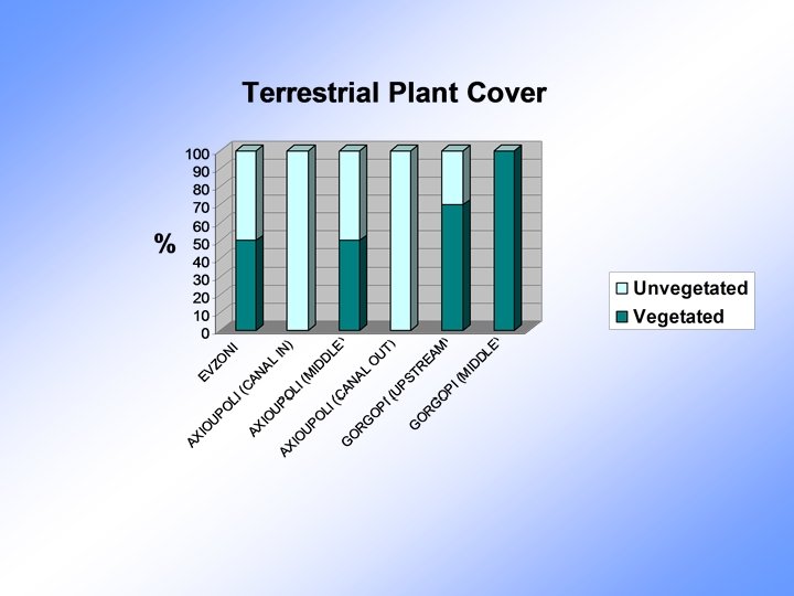
 The banks have a physical profile, mostly undercut and steep, although there are reinforcements at the toe, because of gabions at various locations. The bankfaces have vegetation mostly on the right side with occasional clumps of trees, underwater roots and woody debris. The banktops on the other hand are uniform with tall herbs or bare earth predominate. Land-use beyond the banks is dominated by field and agricultural land.
 EVZONI VEGETATION Shown here are two profiles, one transect covering the riverbank and a cross profile at Evzoni. The vegetation characteristics of Evzoni were mainly grasses and herbs. Where the survey was conducted, over-grazing had occurred by sheep.
 Herbs 15% Grasses 35% Unvegetated 50%") Terestrial vegetation (EVZONI) Herbs 15% Grasses 35% Unvegetated 50%
Terestrial vegetation (EVZONI) Herbs 15% Grasses 35% Unvegetated 50%
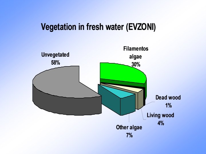
 Vegetation at the station 1 - EVZONI
 Station 1 - Evzoni Xanthium strumarium Paspalum paspaloides www. agralin. nl/prosroni/paspalum. html Myriophyllum spicatum * All the photos (except those taken from the Internet) are from Polunin Oleg, Oxford University, 1969, Flowers of Europe
 PHYSICOCHEMICAL PARAMETERS - EVZONI
 EVZONI
 COMPARISON OF BIOTIC INDICES AT EVZONI
 The high discharge and various substrates could explain the high percentage of Hydropsychidae and Caenidae and the presence of Heptageniidae. According to both indices Evzoni is characterized as a site of good water quality.
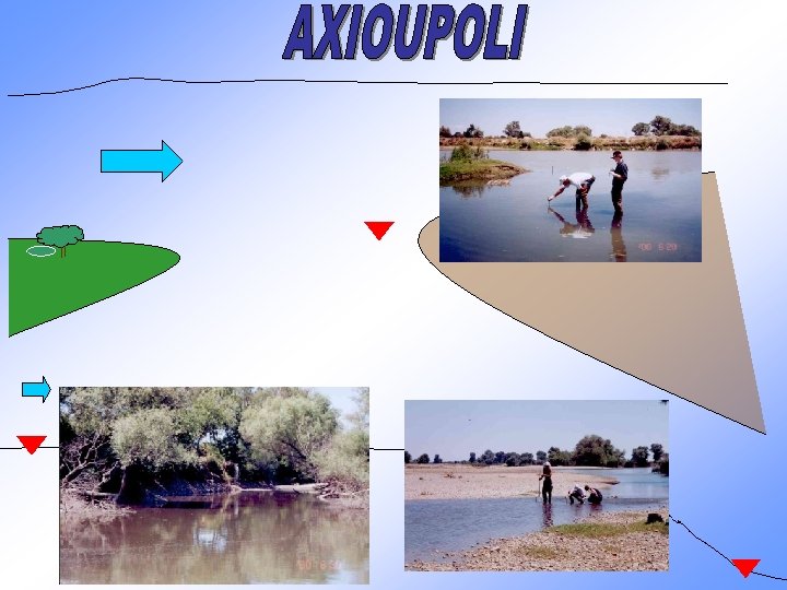
 AXIOUPOLI
 HQA: 52 R. H. S. -AXIOUPOLI HMS: 7 Predominantly unmodified
 RHS-AXIOUPOLI The second site at Axioupoli was also located on a symmetrical floodplain with a channel width of about 86 m and banks that reach up to 2 meters. The predominant material consists of gravel and pebbles almost at the full extent of the channel and at the reach studied, and the flow is smooth, meaning there is just a perceptible flow (glide) with disturbed rippled surface because of the wind. Runs and riffles are also reported, as well as marginal deadwaters. The vegetation in-channel consists of 4 different types limited at the banksides. Deposition features are also important such as side bars and a mid-channel one but the predominant in-channel feature is a big mature island which actually divides the river in a main channel and a side one, where extensive filamentous algae persists in an anoxic environment.
 The banks have a physical profile, mostly steep, but they have also gentle parts which lead to side bars poached by animals or exploited for sandabstraction. There are reinforcements at the toe because of gabions at various locations. On the bankfaces there are isolated trees which affect the channel moderately by their underwater and exposed roots. The banktops are bare with a road along them. Land-use beyond the banks is dominated by tall herbsand agricultural land. A major pollution source from an abattoir was recorded, also litter instream, a roadbridge, nests of birds at the eroding earth cliffs of the banks as well as dragonflies.
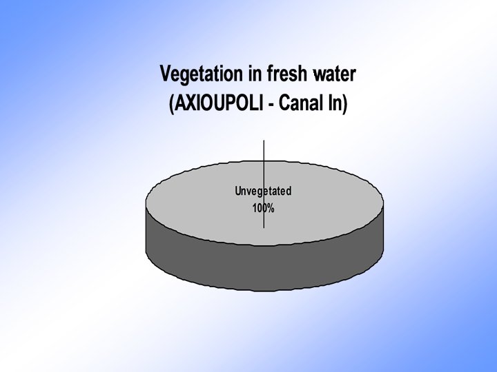
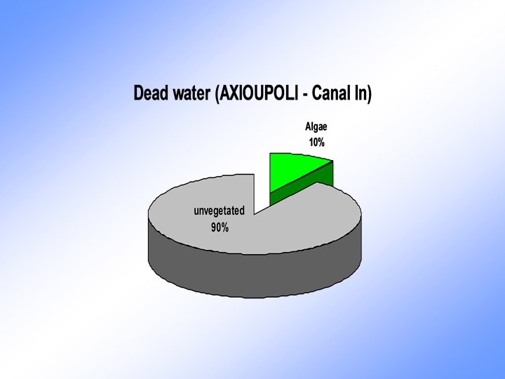
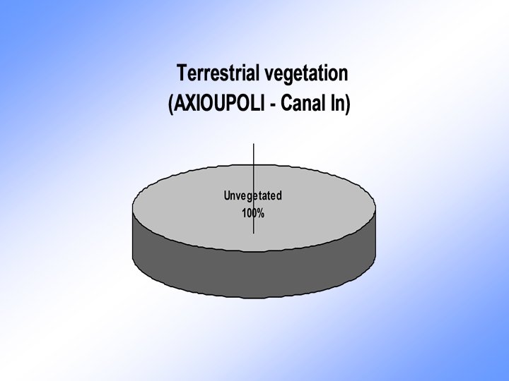
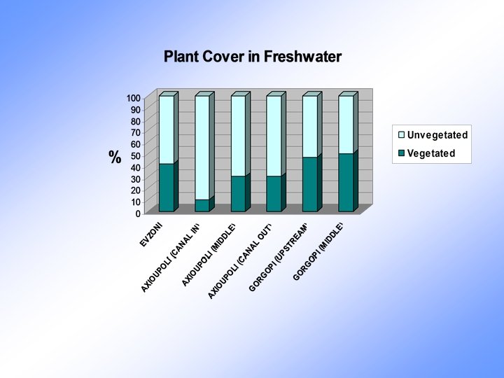
 AXIOUPOLI – Canal In Terrestrial vegetation cover was sparse. It is likely that this is a result of the substrate. However, there had been modifications to the channel flow. Gravel had been moved and disturbed the substrate. In this section of the river, pollution was high, as a result of the abattoir discharge. The presence of freshwater plants was rare and was mainly represented by filamentous algae.
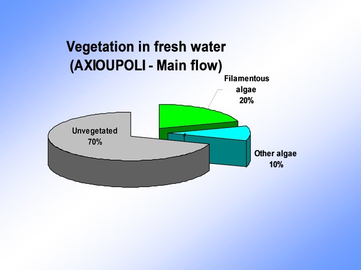
 AXIOUPOLI – Main flow The presence of terrestrial vegetation was dependent upon various factors. These factors were predominantly disturbance from grazing and river flow. At certain parts of the year the side bar could be under water, as a result of higher water level. The substrate was mainly fine gravel. Water retention along the shore surface was poor. The presence of larger macrophytes was low. Filamentous algae was predominant.
 Unvegetated Grassees 30% 50% Herbs 20%") Terestrial vegetation (Axioupoli - Main flow) Unvegetated Grassees 30% 50% Herbs 20%
Terestrial vegetation (Axioupoli - Main flow) Unvegetated Grassees 30% 50% Herbs 20%
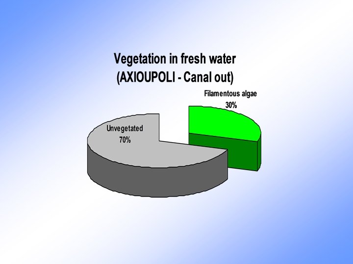
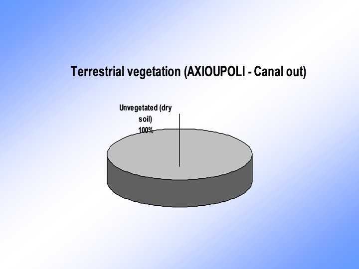
 Further along the canal-out at Axioupoli, green slime was present. Terrestrial") AXIOUPOLI (Canal out) Further along the canal-out at Axioupoli, green slime was present. Terrestrial plant forms were again low nearer to the riverbank, however trees were present further back.
AXIOUPOLI (Canal out) Further along the canal-out at Axioupoli, green slime was present. Terrestrial plant forms were again low nearer to the riverbank, however trees were present further back.
 Vegetation at the station 2 - Axioupoli
 AXIOUPOLI - Station 2 Tamarix africana
 Salix alba http: //www. ddgi. es/espais/salze. htm
 Physicochemical parameters AXIOUPOLI
 AXIOUPOLI CANAL IN
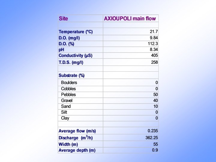
 AXIOUPOLI MAIN FLOW
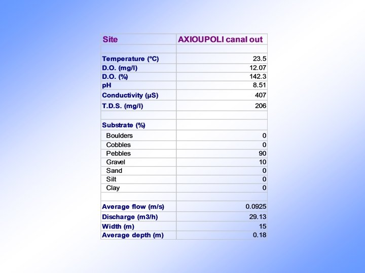
 AXIOUPOLI CANAL OUT
 COMPARISON OF SAMPLING SITES AND BIOTIC INDICES AT AXIOUPOLI
 In this station we observed a big difference between the three sampling sites. In channel we have a very poor water quality mainly because of the effluent of a nearby abattoir, the poor clay substrate and the absence of flow. Under those conditions only Chironomidae and some Oligochaeta can survive. The main part of the river which is of good quality is connected to the outflow of this channel diluting and in this way decreasing the effect of the abattoir effluent. This is also proved at the third sampling site (200 m downstream), where the water quality was better than the one in the first canal in site.
 GORGOPI
 HQA: 41 R. H. S. -GORGOPI HMS: 22 Significantly modified
 RHS-GORGOPI The third site at Gorgopi was also located on a symmetrical floodplain with a channel width of about 6 m and banks that reach up to 1. 70 meters. The predominant material consists of gravel, pebbles and cobbles almost at the full extent of the channel and at the reach studied, creating a variation of flow from smooth(glide) to unbroken standing waves(riffle). Runs and marginal deadwaters are also present. The vegetation in-channel consists of 2 different types limited at the banksides. No deposition features were reported. The banks have an extensively reinforced and embanked profile with parts which lead to side bars poached by animals. On the bankfaces there are clumps of trees with no underwater or exposed roots.
 The banktops have a bare or uniform vegetation structure. Land-use beyond the banks is dominated by tall herbs and agricultural land. The major impact seems to be the extensive reinforcement and the litter along the channel as well as the road along the banks
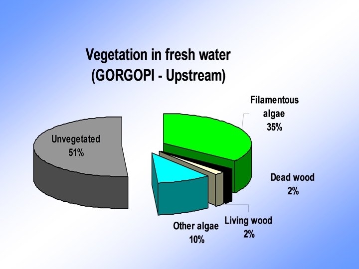
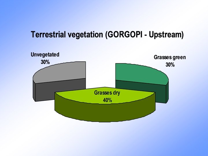
 GORGOPI – Upstream At Gorgopi, the vegetation was variable. On one side of the riverbank - small vegetation was prominent such as lush grasses and small reeds. Further back the grasses were drier. On the opposite side plant vegetation was not present. This may be due to seasonal flow of the river or the type of substrate (large pebbles). Such disturbances might not be beneficial to plant establishment.
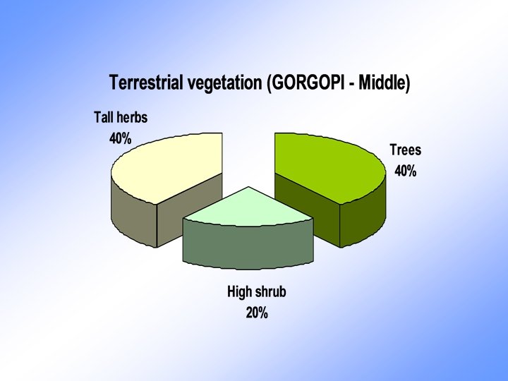
 GORGOPI – Middle Gorgopi - Middle slightly upstream increased in vegetation cover. High shrubs and trees were predominant on the right-hand-side of the river. Again, similar to Gorgopi – Upstream, drier conditions meant small shrubs and grasses were not growing as much.
 Vegetation in the station 3 - GORGOPI
") GORGOPI- Station 3 Plantago coronopus Jungus articulatus Agrostis stolonifera (www. ulusoyseed. com. tr/carmen. html)
GORGOPI- Station 3 Plantago coronopus Jungus articulatus Agrostis stolonifera (www. ulusoyseed. com. tr/carmen. html)
 Mentha longifolia Urtica dubia Veronica persica
 Saponaria officinalis Clematis articulatus Vicia cracca
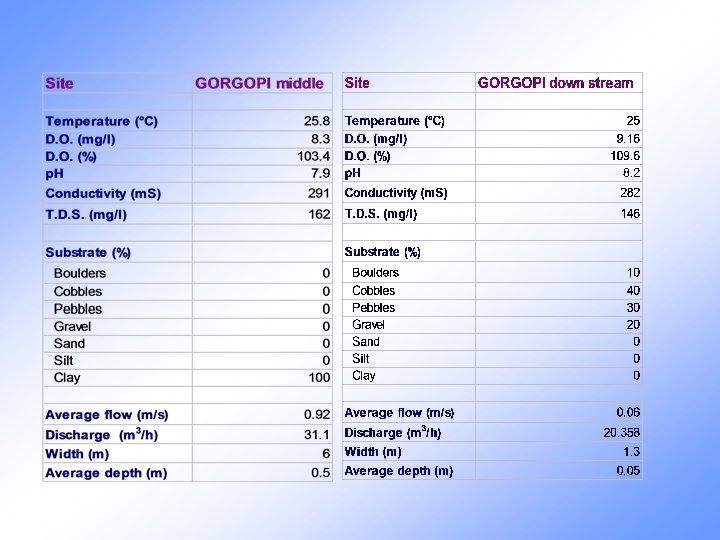
 Physicochemical parameters GORGOPI
 GORGOPI UPSTREAM
 GORGOPI SIDE CHANNEL
 GORGOPI MIDDLE
 GORGOPI DOWNSTREAM
 COMPARISON OF SAMPLING SITES AND BIOTIC INDICES AT GORGOPIS
 In the station we observed the influence of an inflow of excellent quality and great discharge arriving in the main stream (upstream of the pipe: good, downstream of the pipe: excellent). Moreover, it occurred a change in the substrate and the area just after the pipe was composed mainly of clay, whereas the other part of the streambed contained numerous cobbles and pebbles as well. Although clay is a very poor substrate it doesn’t alter the quality of the whole site, because of the high cover of vegetation on the bank side.
 PHYSICOCHEMICAL PARAMETERS KATANTI -ANATOLIKO
 KATANTI ANATOLIKO
 COMPARISON OF BIOTIC INDICES AT KATANTI-ANATOLIKO Comparison of Greek index and ASPT at Katanti- Anatoliko index Katanti- Anatoliko
 The poor quality of this part of the river could be explained by the fact that it is towards the end of the river and so all the diffused pollution is accumulated at this point. Furthermore there is clay substrate, low flow and high conductivity which also contribute to the degradation of the site’s quality.
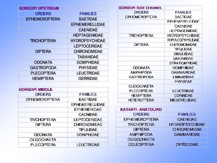
 ORDERS AND FAMILIES IN EACH STATION
 COMPARISON BETWEEN THE WATER QUALITY OF THE STATIONS IN 1997 AND 2000 L. Q. I. 4. 5 Good Evzoni 2000 6/2000 4. 5 Evzoni 1997 6/97 Good In both cases the ASPT score is the same, although in 1997 the habitat was considered to be rich because vegetative habitats were also sampled (Lazaridou. Dimitriadou, 1998), whereas in 2000 poor since the vegetative habitats were not possible to be sampled. This difference did not alternate the total ASPT score and the lincoln Quality Index. In 1997 the 80% of the substrate was consisted of cobbles and pebbles, whereas in 2000 of pebbles and gravel. There was also no important change in the physicochemical parameters. Additionally, in 1998 the same station proved to have moderate quality of water (Drouin et al, 1999)
 L. Q. I. 6/97 6/2000 4 4 Good In Axioupoli, it is Axioupoli 1997 Axioupoli (main flow) 2000 observed that the structure of the macro-invertebrates’ community (as far as the presence- absence parameter is concerned) in 1997 study (Lazaridou-Dimitriadou, 1998) is approximately the same with this study, although in 2000 there are two more low- scoring families, which can’t change the ASPT score. Therefore the water quality in both cases proves to be Good according to LQI. There is also no great difference in the substrate structure (80% is consisted of cobbles and pebbles) as well as in the physicochemical parameters. In 1998 though the water quality was found to be excellent (Drouin et al, 1999)
 L. Q. I. 6/97 5. 5 6 Excellent Gorgopi 1997 6/2000 Excellent In the station of Gorgopi we did not observe a significant difference in the water quality between June of 1997 (Lazaridou. Dimitriadou, 1998) and June of 2000. On the other hand in June of 1998 the water quality was found to be Good (Drouin et al, 1999) The station of Katanti- Anatoliko could not be compared with previous studies, because of the different way of sampling Gorgopi 2000
 SUMMARY OF SAMPLING SITES ALONG THE AXIOS RIVER SHOWING GREEK AND L. Q. I. INDEX VALUES Site names Site 1: Evzoni Site 2: Axioupoli- Canal in Site 3: Axioupoli -Main flow Site 4: Axioupoli- Canal out Site 5: Gorgopis- Upstream Site 6: Gorgopis- Side Channel Site 7: Gorgopis- Middle Site 8: Gorgopis- Downstream Site 9: Katanti-Anatoliko
 Overview of Physico-chemical Parameters The full results for the physico-chemical results are provided in the following Graphs. The following parameters were particularly note worthy. Temperature At Site 1 the temperature was low (19. 8 o. C) and at Site 2 the temperature was lower at 18. 2 o. C. Dissolved Oxygen The main values to note were that at Site 2 (Axioupoli – Canal In) and Site 7 Gorgopis Upstream Dissolved Oxygen was low. Also at Gorgopis Middle and Gorgopis Downstream the values for dissolved oxygen were higher than Gorgopis Upstream. The highest value for dissolved oxygen at Gorgopis was found in the side channel
 p. H The values for p. H at Sites 2 and 7 were low. Six of these sites included p. H values were between 8 -8. 5. Three other sites had p. H values of 7. 5 to 8. 0 Conductivity At Site 2 (Axioupoli) the Micro Siemen values were 514, 405, 407 respectively. There were also high values recorded at Site 9 Kantani Anatoliko). Total Dissolved Solids The first four Sites are high. Included in these are Sites 2 and 3 at Axioupoli. Site 9 (Kantani Anatoliko) was also high. Sites 5, 6, 7 record Lower TDS in comparison.
 the amount of clay and pebbles is high. At Site") Substrate Site 1 (Evzoni) the amount of clay and pebbles is high. At Site 2 (Axioupoli) the substrate mainly consisted of pebbles and fine gravel. Also to note, at Gorgopi (Sites – 5, 6, 7, 8) was that the substrate Mainly consisted of clay, pebbles and cobbles. The last site (No. 9 – Kantani Anatoliko) – only a clay content was present. Average flow A high flow was recorded at Evzoni and Gorgopis. Average River Depth and River Width The average river depth was higher at Sites 3 & 9. For River Width, Sites 1, 3 and 9 were wide.
Substrate Site 1 (Evzoni) the amount of clay and pebbles is high. At Site 2 (Axioupoli) the substrate mainly consisted of pebbles and fine gravel. Also to note, at Gorgopi (Sites – 5, 6, 7, 8) was that the substrate Mainly consisted of clay, pebbles and cobbles. The last site (No. 9 – Kantani Anatoliko) – only a clay content was present. Average flow A high flow was recorded at Evzoni and Gorgopis. Average River Depth and River Width The average river depth was higher at Sites 3 & 9. For River Width, Sites 1, 3 and 9 were wide.
 SITES 1. EVZONI 2. AXIOUPOLI canal in 3. AXIOUPOLI main flow 4. AXIOUPOLI canal out 5. GORGOPI downstream 6. GORGOPI middle 7. GORGOPI upstream 8. GORGOPI side channel 9. Katanti Anatoliko
 1. . EVZONI 6. GORGOPIS – middle 2. AXIOUPOLI – canal in 7. GORGOPIS - upstream 3. AXIOUPOLI – main flow 8. GORGOPIS – side channel 4. AXIOUPOLI – canal out 9. KATANI ANATOLIKO 5. GORGOPIS - downstream
 STATIONS 1. EVZONI 2. AXIOUPOLI canal in 3. AXIOUPOLI main flow 4. AXIOUPOLI canal out 5. GORGOPIS downstream 6. GORGOPIS middle 7. GOR GOPIS upstream 8. GORGOPIS side channel 9. KATAMIC ANTOLICO
 SITES 1. EVZONI 2. AXIOUPOLI canal in 3. AXIOUPOLI main flow 4. AXIOUPOLI canal out 5. GORGOPI downstream 6. GORGOPI middle 7. GORGOPI upstream 8. GORGOPI side channel 9. Katanti Anatoliko
 * * No. 7 is a tributary of River Axios 1. . EVZONI 6. GORGOPIS – middle 2. AXIOUPOLI – canal in 7. GORGOPIS - upstream 3. AXIOUPOLI – main flow 8. GORGOPIS – side channel 4. AXIOUPOLI – canal out 9. KATANI ANATOLIKO 5. GORGOPIS - downstream
 1. . EVZONI 6. GORGOPIS – middle 2. AXIOUPOLI – canal in 7. GORGOPIS - upstream 3. AXIOUPOLI – main flow 8. GORGOPIS – side channel 4. AXIOUPOLI – canal out 9. KATANI ANATOLIKO 5. GORGOPIS - downstream
 1. . EVZONI 6. GORGOPIS – middle 2. AXIOUPOLI – canal in 7. GORGOPIS - upstream 3. AXIOUPOLI – main flow 8. GORGOPIS – side channel 4. AXIOUPOLI – canal out 9. KATANI ANATOLIKO 5. GORGOPIS - downstream
 1. . EVZONI 6. GORGOPIS – middle 2. AXIOUPOLI – canal in 7. GORGOPIS - upstream 3. AXIOUPOLI – main flow 8. GORGOPIS – side channel 4. AXIOUPOLI – canal out 9. KATANI ANATOLIKO 5. GORGOPIS - downstream
 1. . EVZONI 6. GORGOPIS – middle 2. AXIOUPOLI – canal in 7. GORGOPIS - upstream 3. AXIOUPOLI – main flow 8. GORGOPIS – side channel 4. AXIOUPOLI – canal out 9. KATANI ANATOLIKO 5. GORGOPIS - downstream
 * * No. 9 is an approximation 1. . EVZONI 6. GORGOPIS – middle 2. AXIOUPOLI – canal in 7. GORGOPIS - upstream 3. AXIOUPOLI – main flow 8. GORGOPIS – side channel 4. AXIOUPOLI – canal out 9. KATANI ANATOLIKO 5. GORGOPIS - downstream
 Performs a clustering of sampling stations based on : a)") FUZZY CLUSTERING (Equihua, 1990) Performs a clustering of sampling stations based on : a) The presence – absence b) The abundance of benthic macroinvertebrate taxa
FUZZY CLUSTERING (Equihua, 1990) Performs a clustering of sampling stations based on : a) The presence – absence b) The abundance of benthic macroinvertebrate taxa
 FUZZY CLUSTERING Number of sampling stations: 9 Number of taxa: 32 Number of clusters: 4 data transformed into: Log(X+1) Analysis using 4 reciprocal averaging axes Method: fuzzy CMeans Partition coefficient: 0. 584 Membership 0. 5 -0. 75 Membership 0. 75 -1 MEMBERSHIPS Gr 1 Gr 2 Gr 3 Gr 4 1 . 11 . 01 . 87 . 01 2 . 3 . 15 . 37 . 18 3 0 1 0 0 4 . 16 . 01 . 81 . 02 5 . 73 . 03 . 2 . 04 6 . 77 . 01 . 2 . 01 7 . 95 0 . 04 0 8 . 32 . 09 . 48 . 12 9 0 0 0 . 99 1. EVZONI 2. AX. CANAL IN 3. AX. MAIN FLOW 4. AX. CANAL OUT 5. GOR. UPSTREAM 6. GOR. MIDDLE 7. GOR. DOWNSTREAM 8. GOR. SIDE CHANNEL 9. KAT. ANATOLIKO Four groups : - Sites 3 and 9 (independent groups by themselves). - Sites 5, 6, 7 (Gorgopis) - Sites 1, 4 - Sites 2 and 8 do not belong to any of the groups, but are more closely related to the last one.
 • Produces a similarity dendrogram of sampling stations") PRIMER (Field et al. , 1982) • Produces a similarity dendrogram of sampling stations based on the presence – absence and the abundance of benthic macroinvertebrate taxa. • Measures the similarity or dissimilarity of stations and groups of stations, using the Bray-Curtis similarity index. • Explains which families of macroinvertebrates contribute to the similarity or dissimilarity between groups.
PRIMER (Field et al. , 1982) • Produces a similarity dendrogram of sampling stations based on the presence – absence and the abundance of benthic macroinvertebrate taxa. • Measures the similarity or dissimilarity of stations and groups of stations, using the Bray-Curtis similarity index. • Explains which families of macroinvertebrates contribute to the similarity or dissimilarity between groups.
 SIMILARITY DENDROGRAM 1. 2. GOR. MIDDLE 7. GOR. DOWNSTREAM 8. 6 2 GOR. UPSTREAM 6. 5 AX. CANAL OUT 5. 1 7 AX. MAIN FLOW 4. 8 4 AX. CANAL IN 3. 9 3 EVZONI GOR. SIDE CHANNEL 9. KAT. ANATOLIKO 4 groups on 50% level: 1, 4 -8 / 2 (Chironomidae, Oligochaeta) / 3 (Ceratopogonidae, Elminthidae) 9 (Mysidae, Gammaridae) 6 groups on 60% level: 2 / 3 / 9 / 8 (Leuctridae, Simuliidae, Limoniidae) 5 -7 (Ephemerellidae, Leptoceridae, Gomphidae) 1, 4 (Baetidae, Caenidae, Hydropsychidae) On a 60% similarity level an almost identical grouping as to the one of FUZZY is performed.
 -combination of physicochemical values with TAXA") Canoco - Canonical Correspondence Analysis (Ter Braak, 1998) -combination of physicochemical values with TAXA -The values are not combined linearly !! - tries to show which parameters have the most influence !! In our case: -Grouping of Pebbles, Cobbles and Boulders -> coarse -Elimination of values: fine material, T. D. S. , Width, Depth (by Canoco) - Elimination of D. O. (%) [because of unreliable data] - transformation to ln(x+1)
Canoco - Canonical Correspondence Analysis (Ter Braak, 1998) -combination of physicochemical values with TAXA -The values are not combined linearly !! - tries to show which parameters have the most influence !! In our case: -Grouping of Pebbles, Cobbles and Boulders -> coarse -Elimination of values: fine material, T. D. S. , Width, Depth (by Canoco) - Elimination of D. O. (%) [because of unreliable data] - transformation to ln(x+1)
 The Diagram Eigenvalues : . 428 . 283 . 204 . 163 Inter set correlations of environmental variables with axes N NAME AX 1 AX 2 1 TEMP -. 0347 -. 7595 2 D. O. -. 3284 -. 8730 3 p. H . 0560 . 0136 4 COND. . 1439 -. 3954 5 COARSE . 3994 . 4110 6 AVFLOW . 7076 . 0700
 The Diagram Inter set correlations of environmental variables with axes N NAME AX 1 AX 2 1 TEMP -. 0347 -. 7595 2 D. O. -. 3284 -. 8730 3 p. H . 0560 . 0136 4 COND. . 1439 -. 3954 5 COARSE . 3994 . 4110 6 AVFLOW . 7076 . 0700
 important physicochemical values
 Some interesting results: CANOCO produced similar results to both FUZZY and PRIMER (same stations were separated). Station 9 (Anatoliko) was plotted in the far right of the diagram (separately from the other sites). This was probably due to the flow at this site, which was recorded as zero. Station 2 (canal in ) also had a flow of zero, but it was located at a different part of the diagram. This shows that there is another dominant physicochemical influence on the taxa at this site, most probably D. O. Station 8 (Gorgopi side channel) is also separated from the other sites. This was mostly caused by temperature and D. O. (the temperature measured at this site was the lowest in the whole survey). The other Gorgopi stations (5, 6, 7) were grouped because their taxa was influenced by similar parameters, especially by high temperature. Sites 7 and 8 both have excellent water qualities, according to the Greek index, in spite of different positioning. This shows again that CANOCO does no grouping.
 DISCUSSION The river Axios showed great variation in physicochemical parameters, habitat structure and anthropogenic influence along its length with consequences on the benthic communities. Evzoni The physicochemical parameters showed relatively high conductivity, diverse substrate structure and high discharge. The high conductivity was possibly due to runoff and erosion further upstream introducing ions into the river. There was high diversity in the invertebrate families. This was probably due to the variation of substrate. The family Hydropsychidae was the most abundant. This was not surprising since these animals thrive in conditions of high discharge, relatively low temperature and coarse substrate.
 The Greek Index described the site as one of good, but not excellent, water quality. This could be attributed to the prevalence of two families of Ephemeroptera (Caenidae and Baetidae), that tolerate a wide variety of conditions. Axioupoli The first site of Axioupoli (Canal In) was characterized by high temperature, low dissolved oxygen and homogenous clay substrate. Additionally, there was no flow and the substrate was black, indicating anoxic conditions. There was low diversity of invertebrate families. The dominant taxon was the family Chironomidae. This family flourishes in clay and is tolerant of low oxygen and high levels of organic pollution, as was introduced by the abattoir outflow pipe. The Greek Index describes the site as very poor in terms of water quality.
 In terms of the physicochemical values, the main flow and the canal out were similar. They also presented roughly the same number of families and abundance of invertebrates. According to the Greek Index and the BMWP the water quality in both the main flow and Canal Out was good. This implies that the downstream site (Canal Out) was not affected by the Canal In site possibly due to the isolation of Canal In from the main stream, coupled with the lack of flow in the junction of the main stream and Canal In. Another factor could be the dilution of the water, coming from Canal In, by the main flow. The vegetation of the station was sparse. Especially in canal in, due to anthropogenic interference, and in canal out, probably due to the substrate, there were no terrestrial plants at all.
 Gorgopi The Upstream and middle channel sites had similar physicochemical characteristics, with the exception of substrate composition. In the former the substrate was diverse, while in the latter it was composed of clay. This could be due to the scouring of the bottom by the discharge coming from the side channel. This could also explain the heterogeneous substrate of downstream channel. The dissolved oxygen in the downstream site was higher, most probably because of the aeration caused by the weir. The side channel was characterized physicochemically by relatively low temperature (compared to the main channel), probably because of the shading by the surrounding vegetation, high dissolved oxygen and coarse homogenous substrate, providing shelter for invertebrates. So, it was not surprising to find a high diversity of invertebrate taxa (19 families) and excellent water quality, according to the Greek Index and the BMWP.
 There is an apparent influence of the side channel to the middle and downstream sites (excellent) while upstream was only scored as good. In downstream, there was a large number of taxa because of the oxygenation effect of the weir. The bridge seemed to have little effect on the composition of the downstream community. Gorgopi appeared to be more vegetated than the other areas studied. An important feature of the Gorgopi is that the BMWP score showed less differentiation between the four sites then the Greek Index, because of the adaptation of the latter to the Greek ecosystem.
 Katanti – Anatoliko The Greek Index scored the site as of poor quality. This was probably attributed to the physicochemical characteristics, such as high conductivity, clay substrate and lack of flow, at least at the time period of the sampling. However, the results may be biased because of the different sampling method, that was restricted to the banks of the channel. Moreover, the fact that the family Mysidae has been also found, which is a marine family, as well as the large number of Gammaridae (probably including marine species) indicates the probable high salinity of the site. This can be explained by the fact that the Delta of Axios river is lower than the sea level and sea water can enter into the river, even if the river water is always pumped to the sea (Personal comm. with Prof. Maria Lazaridou)
 Statistical analyses All statistical analyses indicate the differentiation of sampling stations into more or less distinct groups. Axioupolis canal in is separated by itself, because of its poor macroinvertebrate fauna (Chironomidae, Oligochaeta) and physicochemical characteristics (low D. O. , clay substrate), which are due to local organic pollution from the abattoir effluents. Anatoliko is also isolated and presents a poor water quality. Besides the different sampling technique, the penetration of sea water and relative macroinvertebrate taxa (Mysidae), as well as its very low flow may contribute to this isolation. Axioupolis main flow is the third sampling station which is set apart from the others. It does not exhibit any extreme values as to its physicochemical parameters, thus its separate positioning may be due to the low abundances of macroinvertebrates.
 form a group") With the exception of side channel, Gorgopis sites (upstream, middle, downstream) form a group of good and excellent water quality. Their macroinvertebrate fauna is quite rich and presents some high-scoring families (e. g. Leptoceridae). It should be noted that these stations are not located on the main course of Axios river, but on one of its tributaries. Finally, Evzoni and Axioupolis canal out also form a distinct group of good quality. Their fauna is mainly characterized by increased abundances of Baetidae, Caenidae and Hydropsychidae. Gorgopis side channel does not clearly belong to any of the groups mentioned above, because of its high diversity of macroinvertebrate families and its physicochemical characteristics, e. g. lowest temperature. However, it is more closely related to the latter group, mainly as to the composition and relative abundance of invertebrates.
With the exception of side channel, Gorgopis sites (upstream, middle, downstream) form a group of good and excellent water quality. Their macroinvertebrate fauna is quite rich and presents some high-scoring families (e. g. Leptoceridae). It should be noted that these stations are not located on the main course of Axios river, but on one of its tributaries. Finally, Evzoni and Axioupolis canal out also form a distinct group of good quality. Their fauna is mainly characterized by increased abundances of Baetidae, Caenidae and Hydropsychidae. Gorgopis side channel does not clearly belong to any of the groups mentioned above, because of its high diversity of macroinvertebrate families and its physicochemical characteristics, e. g. lowest temperature. However, it is more closely related to the latter group, mainly as to the composition and relative abundance of invertebrates.
 the RHS field") RHS DISCUSSION It is important to keep in mind that: a) the RHS field method has been developed specifically for rivers found in the UK, b) it can be used for the comparison of river sites only when it refers to the same river types, c) there is no sufficient database of habitat assessment of rivers in Greece, making difficult the classification and evaluation of newly studied sites.
RHS DISCUSSION It is important to keep in mind that: a) the RHS field method has been developed specifically for rivers found in the UK, b) it can be used for the comparison of river sites only when it refers to the same river types, c) there is no sufficient database of habitat assessment of rivers in Greece, making difficult the classification and evaluation of newly studied sites.
 It is essential that the 3 sites studied must be divided into two groups in order to be able to be compared. 1. Axios sites (Evzoni and Axioupoli) 2. Gorgopi This is due to the fact that: • Gorgopi is a tributary of Axios • Gorgopi’s channel dimensions differentiate it significantly(water width, mean discharge) • Gorgopi’s different size (distance from source is much shorter than Axios)
 AXIOS EVZONI-AXIOUPOLI The HQA and HMS scores of the two sites are very similar, showing a slight better score for Evzoni. The HMS assessment categorizes though both sites as predominantly unmodified.
 Why do these sites present similar HQA/HMS scores? • Similar substrate • Similar flow • Same number of types of in-channel vegetation • Almost same vegetation structure of banks • Similar land-use in the same symmetrical floodplain • Almost same kinds of modifications
 How could the sites be classified? The UK’s database provides a range for HQA scores from 10 to 90, with the majority of sites being around a score of 40 to 60. The existing Greek habitat assessments conducted at steep mountainous streams and at a lowland middle size river provide a range from 48 to 102. As mentioned before it is impossible to draw conclusions since Axios is a different type of river compared to the previous ones but we can get an idea that it classifies itself at least within ranges both present in the UK and in Greece. The only valid conclusion that can be drawn is that there exists a steady condition between the two sites. This means that the two sites are of almost equal habitat quality and value.
 Is there a relationship between the HQA/HMS scores and the Greek biotic indices of the sites? Firstly, it is important to know that high HQA/HMS scores does not necessarily mean a good quality of water. Comparing the 2 sites it seems that their habitat similarity has a linear relationship with the water quality as produced by the Greek Index. It must only be mentioned that the index of the middle channel was taken into consideration since it referred to the main flow of the river.
 GORGOPI There is no possible comparison of this score with another site. However, by comparing the HQA/HMS scores and the Greek Index there seems to be a significant difference, since the RHS shows a low habitat quality and a significantly modified channel, while the Index an excellent water quality. This is mainly due to the fact that the habitat changes significantly downstream of the invertebrates’ sampling site and that the RHS scores don’t necessarily ensure an analogous presence of species.
 Managerial proposals The Axios river is one of the most important in Greece, given the fact that a valley of 30 km width surrounds the river. This valley supports a great production of agricultural goods. The river itself is subjected to anthropogenic influences and to the special hydrologic and climatic conditions of the Mediterranean ecosystem. Concerning the part of the river that flows in Greece, the human intervention is intense. This fact can be also seen in our results (physicochemical parameters and benthic macroinvertebrates) (Lazaridou et al. , 1998). Some proposals for the management of the stations studied are presented below:
 Ø Evzoni which was our first station is the closest one to the borders with FYROM. Although it is not characterized by intense anthropogenic influence by the surrounding area, we do not know what are the influents from FYROM and thus we cannot assess the water quality. A cooperation with the neighboring country could lead to a more intergraded monitoring of the Axios river. ØThe station of Axioupoli is situated close to an abattoir that leads its wastes to a channel of the river. The wastewater is treated only primarily. • A more advanced treatment should be taken up by the abattoir • The waste water pipe could be lead directly to the main flow so that it can be diluted more efficiently • The side channel could play the role of a natural treatment tank. There is a kind of isolation from the main river so the removal of sediment and the aeration of the side channel could result in an effective treatment.
 Ø Gorgopis is a tributary of the Axios river. Gorgopis has the best water quality of all the stations studied. Generally, this river receives little agricultural runoff and the organic load is extremely low. However there are some anthropogenic modifications like embankment and litter concentrated on the banks (Lazaridou et al. , 1998). It doesn’t seem to affect the water quality as much. A lot of care is required to prevent future problems. Ø Katanti- Anatoliko is located below the Fragma Ellis dam and just before the formation of Axios delta. There is intense abstraction for irrigation purposes and although the discharge at this point is high the amount of the removed water should be controlled. Industries use water from the river for cooling and also to reject waste water. It is very important to prevent toxic substances from going into the river. This could be achieved by enforcing current legislation.
 Transportation") BIBLIOGRAPHY Albanis, A. A. , Danis, T. G. , Kourgia, M. K. (1994) Transportation of pesticides in estuaries of the Axios, Loudias and Aliakmon rivers (Thermaikos Gulf), Greece. Sci. Total environ. 156. pp. 11 -22. Argiropoulos, D. , Van Gills (1991) Axios River Basin. Part 1: Main Report, Part 2: Model Report, Part 3: Data Report. Delft Hydraulics for the Ministry of the Environment. Armitage, P. D. , Moss, D. , Wright, J. F. & Furse, M. T. (1983). The performance of a new biological water quality score system based on macroinvertebrates over a wide range of unpolluted running water sites. Wat. Res. 17. pp. 333 -347 Chesters, R. K. , (1980). Biological Monitoring Working Party. The 1978 National testing exercise. Department of Environment. Water Data Unit. Technical memorandum 19. pp. 1 -37 Drouin, S. A. , V. Artemiadou, M. Lazaridou- Dimitriadou and K. N. White, Lekkas 1999, An integrated water quality assessment of the river Axios during the 1998 low flow season (in Greek) Proceedings of the 6 th international conference of environmental science and technology, Vol. 1
BIBLIOGRAPHY Albanis, A. A. , Danis, T. G. , Kourgia, M. K. (1994) Transportation of pesticides in estuaries of the Axios, Loudias and Aliakmon rivers (Thermaikos Gulf), Greece. Sci. Total environ. 156. pp. 11 -22. Argiropoulos, D. , Van Gills (1991) Axios River Basin. Part 1: Main Report, Part 2: Model Report, Part 3: Data Report. Delft Hydraulics for the Ministry of the Environment. Armitage, P. D. , Moss, D. , Wright, J. F. & Furse, M. T. (1983). The performance of a new biological water quality score system based on macroinvertebrates over a wide range of unpolluted running water sites. Wat. Res. 17. pp. 333 -347 Chesters, R. K. , (1980). Biological Monitoring Working Party. The 1978 National testing exercise. Department of Environment. Water Data Unit. Technical memorandum 19. pp. 1 -37 Drouin, S. A. , V. Artemiadou, M. Lazaridou- Dimitriadou and K. N. White, Lekkas 1999, An integrated water quality assessment of the river Axios during the 1998 low flow season (in Greek) Proceedings of the 6 th international conference of environmental science and technology, Vol. 1
 River Habitat Survey: 1997 Field Survey Guidance Manual, Incorporating Sercon. Equihua,") Environment Agency (1997) River Habitat Survey: 1997 Field Survey Guidance Manual, Incorporating Sercon. Equihua, M. (1990). FUZZY clustering of ecological data. J. Ecol. 78. pp. 519 -534 Field, J. G. , Clarke, K. R. & Warwick, R. M. (1982). A practical strategy for analyzing for multispecies distribution patterns. Marine Ecology Progress Series 8. pp. 37 -52 Lazaridou-Dimitriadou, M. , (1998). Examination of the ecological quality of the surface waters of Central and West Macedonia, using biological indices. Report to General Secretary of Research and Technology, Thessaloniki. Lazaridou-Dimitriadou, M. , Artemiadou, V. , Yfantis, G. , Mourelatos, S. & Mylopoulos, Y. (2000). Contribution to the ecological quality of Aliakmon river (Macedonia, Greece): a multivariate approach. Hydrobiologia. 410. Pp. 47 -58.
Environment Agency (1997) River Habitat Survey: 1997 Field Survey Guidance Manual, Incorporating Sercon. Equihua, M. (1990). FUZZY clustering of ecological data. J. Ecol. 78. pp. 519 -534 Field, J. G. , Clarke, K. R. & Warwick, R. M. (1982). A practical strategy for analyzing for multispecies distribution patterns. Marine Ecology Progress Series 8. pp. 37 -52 Lazaridou-Dimitriadou, M. , (1998). Examination of the ecological quality of the surface waters of Central and West Macedonia, using biological indices. Report to General Secretary of Research and Technology, Thessaloniki. Lazaridou-Dimitriadou, M. , Artemiadou, V. , Yfantis, G. , Mourelatos, S. & Mylopoulos, Y. (2000). Contribution to the ecological quality of Aliakmon river (Macedonia, Greece): a multivariate approach. Hydrobiologia. 410. Pp. 47 -58.
 Examination of the water quality network stations of") Pitsavas, X. & Ganidou, M. (1996) Examination of the water quality network stations of the Macedonian and Thrace Ministry: Report for the years 1992 -1994. Macedonian and Thrace Ministry, Department of environmental protection, Aquatic Pollution Section. Polunin Oleg, Oxford University, 1969, Flowers of Europe (All vegetation photos and plant occurrence table). The data were used without permission from the editor. Raven, P. J. , Holmes, N. T. H. , Dawson, F. H. , Fox, P. J. , Everard, M. , Fozzard, I. R. & Rouen, J. (1998) River Habitat Quality: the physical character of rivers and streams in the UK and Isle of Man. Environment Agency. Ter Braak, C. J. F. , (1988). CANOCO – A FORTRAN program for canonical community ordination (version 2. 1). Technical Report: LWA-88 -02.
Pitsavas, X. & Ganidou, M. (1996) Examination of the water quality network stations of the Macedonian and Thrace Ministry: Report for the years 1992 -1994. Macedonian and Thrace Ministry, Department of environmental protection, Aquatic Pollution Section. Polunin Oleg, Oxford University, 1969, Flowers of Europe (All vegetation photos and plant occurrence table). The data were used without permission from the editor. Raven, P. J. , Holmes, N. T. H. , Dawson, F. H. , Fox, P. J. , Everard, M. , Fozzard, I. R. & Rouen, J. (1998) River Habitat Quality: the physical character of rivers and streams in the UK and Isle of Man. Environment Agency. Ter Braak, C. J. F. , (1988). CANOCO – A FORTRAN program for canonical community ordination (version 2. 1). Technical Report: LWA-88 -02.
 At the end we would like to thank: Maria Lazaridou- Dimitriadou Brian Hemsley- Flint Gustav Hellden Kurt Prackwieser Ian Humpheryes Paul Smith Lila Artemiadou Mantha Lekka for their help.