

a8451815766c1a3415316de625e8c428.ppt
- Количество слайдов: 37
 Conceptualize the user's view of data – what") Specific Steps in Data Modeling (1) Conceptualize the user's view of data – what are the basic features needed to solve the problem? (2) Select the geographic representation – points, lines, areas, rasters, TINs (3) Define objects, features, and relationships – draw a UML diagram, specify relationships, “behaviors” (4) Match to geodatabase elements – Refine relationships, “behaviors” (5) Organize geodatabase structure, add data
Specific Steps in Data Modeling (1) Conceptualize the user's view of data – what are the basic features needed to solve the problem? (2) Select the geographic representation – points, lines, areas, rasters, TINs (3) Define objects, features, and relationships – draw a UML diagram, specify relationships, “behaviors” (4) Match to geodatabase elements – Refine relationships, “behaviors” (5) Organize geodatabase structure, add data
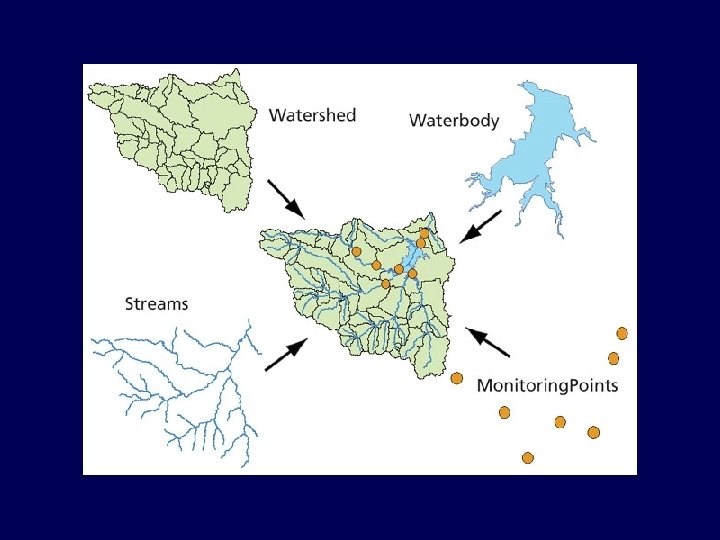
 User’s View of Data") ( 1 ) User’s View of Data
( 1 ) User’s View of Data
 User’s View of Data cont.") ( 1 ) User’s View of Data cont.
( 1 ) User’s View of Data cont.
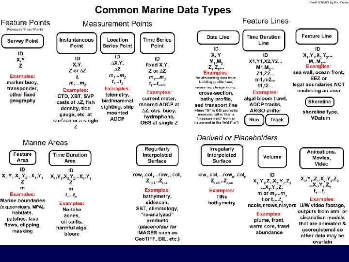
 Select geographic rep.") (2) Select geographic rep.
(2) Select geographic rep.
 Conceptualize the user's view of data – what are") Steps in Data Modeling (1) Conceptualize the user's view of data – what are the basic features needed to solve the problem? (2) Select the geographic representation – points, lines, areas, rasters, TINs (3) Define objects and relationships – draw a UML diagram, specify relationships, “behaviors” (4) Match to geodatabase elements – Refine relationships, “behaviors” (5) Organize geodatabase structure, add data
Steps in Data Modeling (1) Conceptualize the user's view of data – what are the basic features needed to solve the problem? (2) Select the geographic representation – points, lines, areas, rasters, TINs (3) Define objects and relationships – draw a UML diagram, specify relationships, “behaviors” (4) Match to geodatabase elements – Refine relationships, “behaviors” (5) Organize geodatabase structure, add data
 Unified Modeling Language • Entity-relationship diagrams • Design methodologies, diagram notations • UML – Not a design methodology – Just a diagrammatic notation based on methods – Endorsed by leading software and database companies • HTML
 Unified Modeling Language UML • Diagrammatic notation = “visual language”. . . • For constructing a data model – Explains, documents on object-oriented structure • Drawings, relationships constructed in Visio – Like CAD for Civil Engineering • Tools to input a drawing to Arc. GIS – input data to the data model
 Basic UML Grammer • Things – “Classes” sometimes grouped in “Packages” • Relationships • Diagrams
 UML Things
 UML Notation Zeiler pp. 97 -99 • a class is shown as a box • top part contains the name of the class • lower part contains the attributes • methods associated with the class • lines connect boxes and indicate relationships
 • Abstract class – specify subclasses underneath – Mammals") UML Notation ( cont. ) • Abstract class – specify subclasses underneath – Mammals w/human or dog feature classes – no new instances • Feature Class – Specify subtypes underneath – Human, dog, cat
UML Notation ( cont. ) • Abstract class – specify subclasses underneath – Mammals w/human or dog feature classes – no new instances • Feature Class – Specify subtypes underneath – Human, dog, cat
 Example: Chicken Object Model
 Graphic courtesy of Maidment et al. , Arc. Hydro team
 – in Arc. GIS an object is") Objects and Features • Object (real world) – in Arc. GIS an object is non-spatial – it is NOT a point, line, or area – it has no geographic location – it has no shape attribute in its table – Drainage network, ship, vehicle, … customer, lake, house, etc. • Feature (spatial context) – an object that has geographic location – a point, line, area, TIN, raster
Objects and Features • Object (real world) – in Arc. GIS an object is non-spatial – it is NOT a point, line, or area – it has no geographic location – it has no shape attribute in its table – Drainage network, ship, vehicle, … customer, lake, house, etc. • Feature (spatial context) – an object that has geographic location – a point, line, area, TIN, raster
 Relationships • Links between classes, shown as lines • One to one • One to many • Many to many
 • 1: 1 - solid line – one record in Class") Relationships (cont. ) • 1: 1 - solid line – one record in Class A linked to one record in Class B • “is married to” • the class of state capitals linked to the class of states • 1: n - solid line with * at one end – one record in Class A linked to any number of records in Class B • "owns" • the class of states linked to the class of area codes
Relationships (cont. ) • 1: 1 - solid line – one record in Class A linked to one record in Class B • “is married to” • the class of state capitals linked to the class of states • 1: n - solid line with * at one end – one record in Class A linked to any number of records in Class B • "owns" • the class of states linked to the class of area codes
 • m: n - solid line with * at both ends") Relationships (cont. ) • m: n - solid line with * at both ends – any number of records in Class A linked to any number of records in Class B • "has visited” • "was never married to" • the class of mountain lions linked to the class of wilderness areas
Relationships (cont. ) • m: n - solid line with * at both ends – any number of records in Class A linked to any number of records in Class B • "has visited” • "was never married to" • the class of mountain lions linked to the class of wilderness areas
 Graphic courtesy of Maidment et al. , Arc. Hydro team
 of") Type Inheritance • White triangle • Class B inherits the properties (attributes, methods) of Class A • the class street inherits from the class transportation network • Solid diamond • the parts and the whole depend on each other
Type Inheritance • White triangle • Class B inherits the properties (attributes, methods) of Class A • the class street inherits from the class transportation network • Solid diamond • the parts and the whole depend on each other
 Graphic courtesy of Maidment et al. , Arc. Hydro team
 Michael Blongewicz X Instantaneous. Points Time. Stamp Y Measurement Measuring.") Instantaneous. Point (ex: CTD) Michael Blongewicz X Instantaneous. Points Time. Stamp Y Measurement Measuring. Device Z Measured. Type Measured. Data
Instantaneous. Point (ex: CTD) Michael Blongewicz X Instantaneous. Points Time. Stamp Y Measurement Measuring. Device Z Measured. Type Measured. Data
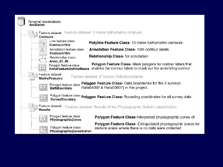
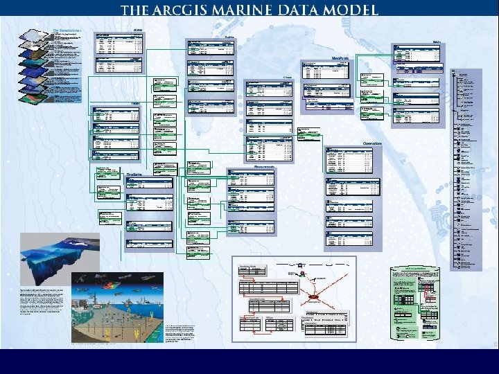
 Arc. Marine Geodatabase Overall Geodatabase Feature Class Feature Dataset Table Relationship Class
 Conceptualize the user's view of data – what are") Steps in Data Modeling (1) Conceptualize the user's view of data – what are the basic features needed to solve the problem? (2) Select the geographic representation – points, lines, areas, rasters, TINs (3) Define objects and relationships – draw a UML diagram, specify relationships, “behaviors” (4) Match to geodatabase elements – Refine relationships, “behaviors” (5) Organize geodatabase structure, add data
Steps in Data Modeling (1) Conceptualize the user's view of data – what are the basic features needed to solve the problem? (2) Select the geographic representation – points, lines, areas, rasters, TINs (3) Define objects and relationships – draw a UML diagram, specify relationships, “behaviors” (4) Match to geodatabase elements – Refine relationships, “behaviors” (5) Organize geodatabase structure, add data
 Data Model Levels Humanoriented Reality Conceptual Model Logical Model Computeroriented Physical Model Increasing Abstraction
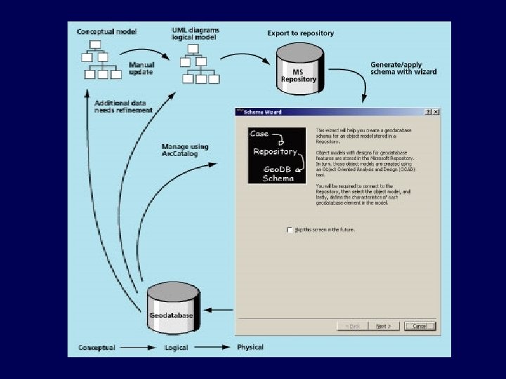
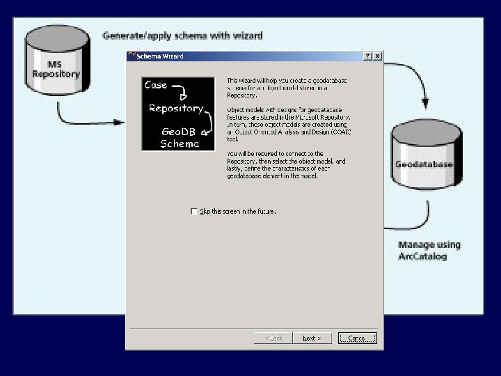
 Modeling Process Conceptual Model Lists, flow diagrams, etc Real World Objects and relationships Logical Model Diagram in CASE Tool Physical Model Database Schema (Object state) Graphic courtesy of ESRI

 Conceptualize the user's view of data – what are") Steps in Data Modeling (1) Conceptualize the user's view of data – what are the basic features needed to solve the problem? (2) Select the geographic representation – points, lines, areas, rasters, TINs (3) Define objects and relationships – draw a UML diagram, specify relationships, “behaviors” (4) Match to geodatabase elements – Refine relationships, “behaviors” (5) Organize geodatabase structure, add data – e. g. , Marine Data Model tutorial
Steps in Data Modeling (1) Conceptualize the user's view of data – what are the basic features needed to solve the problem? (2) Select the geographic representation – points, lines, areas, rasters, TINs (3) Define objects and relationships – draw a UML diagram, specify relationships, “behaviors” (4) Match to geodatabase elements – Refine relationships, “behaviors” (5) Organize geodatabase structure, add data – e. g. , Marine Data Model tutorial
 Arc Marine Data Model Exercise • Exercise and data at dusk. geo. orst. edu/djl/arcgis/Arc. Marine_Tutorial/ • What to turn in: – Screen snapshot of what your Arc. Map session looks like at the end of Section 4 (including dynseg referencing) – Answers to 2 simple questions at end of Section 4 (which cruise? which vehicle? ) – Can put all of the above in a single MS-Word document, labeled with your NAME please! • Due in Dropbox, May 3 rd, 6: 00 p. m.
 Gateway to the Literature • • Arctur, D. and Zeiler, M. , 2004, Designing Geodatabases, ESRI Press Lowe, J. W. , 2003. Flexible data models strut the runway. Geospatial Solutions, 13(2): 44 -47. Maidment, D. R. , 2002. Arc Hydro: GIS for Water Resources, ESRI Press, 203 pp. w/CD. Li, X. and M. E. Hodgson, 2004. Vector field data model and operations. GISci. Rem. Sens. , 41(1): 1 -24. • Wright, D. , Blongewicz, M. , Halpin, P. , and Breman, J. , A new object-oriented data model for coasts, seas, and lakes, in Green, D. R. (ed. ), Coastal and Marine Geospatial Technologies, London: Springer, in press. • – dusk. geo. orst. edu/djl/arcgis/coastgis_book_final. pdf Wright, D. J. , Halpin, P. N. , Blongewicz, M. J. , and Breman, J. B. , Arc Marine: GIS for a Blue Planet, Redlands, CA: ESRI Press, in prep and review, due out 2006/7. – dusk. geo. orst. edu/djl/arcgis/book
 Resulting Analysis - Arc. Hydro From Arctur and Zeiler, Geodatabase Design, ESRI Press.