

796ace4f24f0d2a89bc4244f76af71af.ppt
- Количество слайдов: 49
 Session 7 GPS Orientation ONE
 Outline of Presentation F GPS, how it works & what you need to check. F Basic receiver functions – what is it telling you? F Selecting a GPS receiver.
 How does GPS work? GPS is a satellite navigation system developed by the US Dept. of Defense (DOD). F GPS provides continuous, all-weather, three-dimensional positioning information (position, velocity and time). F F GPS is used by aviators, mariners, surveyors, truck and auto operators, and hikers.
 5 ft wide 17. 5 ft long 1, 860 lbs
 Delta II
 Confused yet?
 How GPS works in a few logical steps
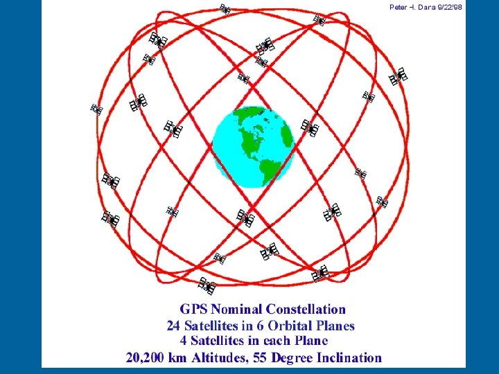
 The basis of GPS operation is ‘triangulation” from the overhead satellites in view.
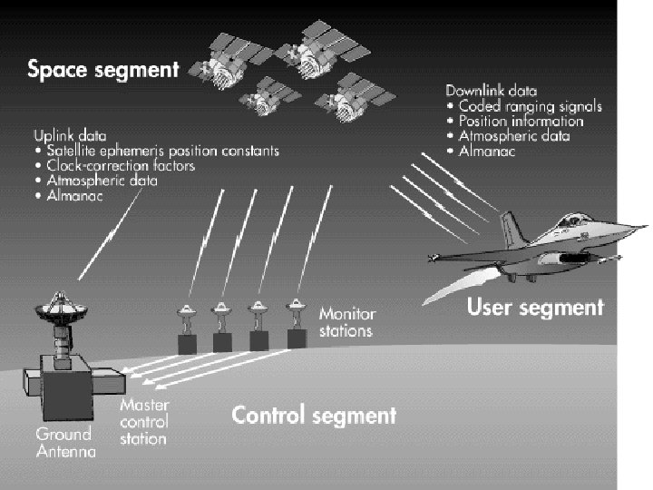
 In order to triangulate, your GPS receiver measures the distance from a satellite using the time of travel of the radio signals from the satellite.
 In order to measure time of travel, a GPS set needs very accurate time which is achieved with some electronic tricks.
 Along with the distance, the satellite must know exactly where it is positioned in space at all times. High orbits and careful monitoring are required.
 All delays that the GPS signal experiences as it travels through the atmosphere must be corrected.
 ANIMATION
 95% of time F DGPS < 10") Specifications Accuracy F GPS 10 meters(33 ft) 95% of time F DGPS < 10 meters (33 ft) F Availability--99. 85% F Coverage--world of time wide
Specifications Accuracy F GPS 10 meters(33 ft) 95% of time F DGPS < 10 meters (33 ft) F Availability--99. 85% F Coverage--world of time wide
 SUMMARY F GPS positions are not error free – User and/or Satellite clock bias. – Satellite signal can be blocked. – Atmospheric interference is possible. – Poor satellite geometry is possible. You can monitor these errors with your GPS receiver.
 Signal Quality and Accuracy F The height of the bars in display shows signal quality from each satellite F The number of items show the positions of satellites currently in view to your GPS.
 is a measure of satellite fix geometry quality F Figure") Dilution of Precision (DOP) is a measure of satellite fix geometry quality F Figure at far left has lower (better) DOP Poor Geometry F GPS receivers measure and display DOP F Good Geometry
Dilution of Precision (DOP) is a measure of satellite fix geometry quality F Figure at far left has lower (better) DOP Poor Geometry F GPS receivers measure and display DOP F Good Geometry
 Estimated Position Error “EPE” F Many GPS units display EPE – It uses satellite geometry plus other calculations to improve accuracy of the estimated position error – EPE is expressed in feet or meters – user choice
 CEP = Circular Error Probable SEP = Spherical Error Probable SA – Selective Availability Error
 24 hours 5/1/2000 24 hours 5/2/2000 With 95 % of the time within 45 meters within 6. 3 meters or 148 Feet or 21 Feet
 enables local corrections for errors") DGPS (operated by USCG) enables local corrections for errors
DGPS (operated by USCG) enables local corrections for errors
 DGPS Series of coastal stations broadcast corrections to GPS signal. F Former RDF stations used for this purpose. F Note: Stations on Great Lakes not shown on this illustration F Accuracy improved to better than 10 meters.
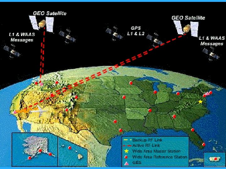
 WAAS – Wide Area Augmentation System of ground-based reference stations and two stationary satellites that broadcast precision differential GPS corrections.
 Be sure that the GPS that you purchase has") Typical GPS with SA OFF) Be sure that the GPS that you purchase has WAAS Less than 10 WAAS capability. feet of error Typical DGPS
Typical GPS with SA OFF) Be sure that the GPS that you purchase has WAAS Less than 10 WAAS capability. feet of error Typical DGPS
 Other things to consider when buying a GPS set.
 Intended Use How are you going Imagine your worst case scenario: to adjust – Stormy conditions. or read – Waves beating on the hull. – your GPS set in Boat bouncing back and forth. – Windshield covered with salt spray. these let go of the helm without – You can’t conditions? F losing control of your boat.
 Mounting Capability Think about the magnetic influence that your GPS has on your compass! v. Mount near the helm. You can’t just lay the GPS v. Swivel capability so that it can be used or read by others. on the dash. v. Adjustable for sun glare. Think offrom theworst case your weather. v. Protected scenario. v. Ability to view satellites.
 Screen Size F Can you read the display at a distance? F Avoid sets with tiny numbers and letters. F Some sets sacrifice readability for more chart area on their screens. F If you can’t clearly read the screen at an arm’s length, you won’t be happy with the set in stormy conditions.
 Ray. Nav 300
 Waterproof versus Submergible Waterproof means that the device will survive a little dampness. Water Resistant means it won’t last long in a moist, damp marine environment. Submergible means that the device will survive a dunking in the ocean.
 Display Lighting Buy a back-lighted display so you can view it at night. Color displays are usually easier to read than black and white. Viewable in bright sunlight. Glare resistant screen.
 12 v Attachment FBe sure your set comes with a power cord that will attach to your boat’s 12 V system. FCarry spare batteries for backup.
 Key and Keyboard Size FKeys too small for your fingers. FLack of keys. FThe argument for preplanning your trips.
 GPS Age and Processor Size The faster a GPS calculates, the FSmaller the data that more accuratecomputingit generates. capability. Most GPS projections are averages FSlower to calculate. of past activity. FLess options. Should be regenerating position at FNo DGPS or WAAS. least once per second.
 Chart Plotters It. Fis not have but practice to be Nice to a safe not really necessary. a chart plotter gazing at F Colored charts are a definite monitor when you should plus. be focusing on the other F Paper charts are easier to read boats sunlight. in bright and obstructions around you.
 Ray. Chart 420
 Display Clutter F Too much data being presented on a small screen. What you eliminate F Have to adjust your screen to remove in the close-up area some data. views, you also lose F Such as, depth readings, aids to navigation, etc. in the wide-area display views.
 Screen Capabilities Minimize your dependencyfrom one F How easy is it to switch on a GPS screen. to another? screen Focus onon a few navigation screens F Focus handling your boat. for everyday use. Pre-plot your trip. F Avoid having to jump a multiple Use a nautical chart and totrip log. screens for basic navigation data. Use your GPS as a quality control check for this process.
 Remote Antenna Need FGPS need a clear view of the satellites. FMay need a remote antenna on your boat.
 Remote
 Multiplexing vs Parallel Receivers Only buy a parallel GPS receiver. F Multiplexing receivers often have only one channel to tune into satellites. F Parallel receivers can acquire several satellites at a time. Come in 3 – 5 – 8 and 12 channel versions. – More accurate processing – Quicker start ups.
 GPS Sensor Design F NMEA – National Marine Manufacturers Association F Standard sensor capability to RADAR, Chart Plotters, Depth Sounders, etc. F Not all sensors are compatible to other manufacturer’s equipment. F Check to be certain.
 Used Sets The price is so low. buy new! The best price for a used set is FREE.
 GPS Tips FGPS looks like a compass FGPS acts like a compass FTherefore it must be a compass WRONG!!!!!!!
 Any questions about? AV Task 6 -1 Differences between GPS, DGPS and WAAS – page 139.