

6e3ab0b63da07ad77e0dd453039271a5.ppt
- Количество слайдов: 50
 SCGEO 3110 Engineering Geology Lecture 1 – 2 nd August 2011
 Observed trends in Australian NRM Move to regional empowerment Move to assets-based approach Move to market-based solutions Increasing skills shortage and high staff turnover Information, data & knowledge is lost, forgotten & ignored Increasing reliance on predictive models More policy driven by alarm Increasing corporate land-use
 Water management • Surface water, groundwater • Quantity, quality") NRM issues (current, emerging, urgent) Water management • Surface water, groundwater • Quantity, quality • Environmental allocations, water re-use • land-use vs. water use Carbon management • CO 2 reduction, sequestration • Carbon tax, carbon market • Biofuels, plantations • Sustaining biodiversity Geohazard management • Soil erosion & landslides • Salinity, waterlogging • Floods, sediment movement • Coastal erosion & deposition Socio-geographic management • Urbanisation, peri-urban growth • Coastal development • Changing agricultural communities • Threats to biodiversity
NRM issues (current, emerging, urgent) Water management • Surface water, groundwater • Quantity, quality • Environmental allocations, water re-use • land-use vs. water use Carbon management • CO 2 reduction, sequestration • Carbon tax, carbon market • Biofuels, plantations • Sustaining biodiversity Geohazard management • Soil erosion & landslides • Salinity, waterlogging • Floods, sediment movement • Coastal erosion & deposition Socio-geographic management • Urbanisation, peri-urban growth • Coastal development • Changing agricultural communities • Threats to biodiversity
 Geohazards Earthquakes Tsunamis Coastal erosion Floods Volcanic eruptions Permafrost Soil erosion Landslides and rockfalls Sinkholes and collapsing soils Acid sulfate soils Reactive soils Salinity and sodicity Karst and soluble rocks Contaminated soils
 Geohazards – Volcanic hazards Hawaii
 Geohazards – Volcanic hazards Pyroclastic flows Lahars Gas emissions Dust Climate changes Environmental devastation Washington
 Geohazards - Earthquakes Measured by magnitude & intensity Earthquake wave components – P, S, L, R Greatest loss of life for geohazards e. g. • Aleppo, Syria 1138, 230, 000 dead • Shaanxi, China 1556, 830, 000 dead • Lisbon, Portugal 1755, 100, 000 dead • Gansu, China 1920, 200, 000 dead • Tokyo, Japan 1923, 140, 000 dead • Tangshan, China 1976, 242, 000 dead • Sumatra, Indonesia 2004, 230, 000 dead Knock-on effects = Tsunamis, landslides, fires, diseases, famine, etc.
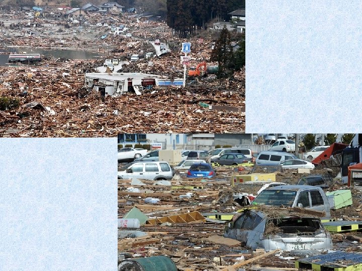
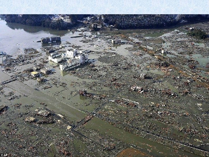
 Japan 11 th March 2011 ML 9. 0 20, 448 dead
 Canterbury, N. Z. 2010 & 2011
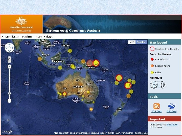
 Geohazards - Earthquakes Australia experiences intraplate seismicity. In eastern Australia the depths are relatively shallow, under 20 km, whereas in subduction zones earthquakes are generated at 700 km deep. < 70 km are shallow, >300 km are deep. 28 July 2011 Orbost ML 2. 2 10 July 2011 Bright ML 3. 1 6 July 2011 Korumburra ML 3. 3 5 July 2011 Korumburra ML 4. 4 Almost all Australian earthquakes are associated with known faults. Therefore low maximum magnitudes of
 Geohazards - Earthquakes Likelihood ü Historic data collection and collation ü Seismic record ü Geology mapping ü Fault mapping ü Soil mapping ü Microsiesmic surveys Consequence ü Historic data collection and collation ü Building susceptibility (homes, hospitals, public offices…) ü Infrastructure susceptibility (road, bridges, sewerage…) ü Utility conduits (gas, power, water, telecommunications…) ü Industry (refineries, biohazards, nuclear hazards…) ü Emergency services (police, ambulance, fire…)
 Geohazards - Landslides Wild Dog Road, 1979
 Geohazards - Landslides Landslide mechanics
 Geohazards - Landslides Landslide mechanics Destabilising forces Gravity Water Loads Undercutting
 Stabilising forces Retain the slope Unload the slope Drain the slope Anchor the slope Landslide mechanics
 Negative Seasonal pumps Wind loads The effect of trees Positive Pump water Reduce infiltration Additional weight Infiltration pathways Root reinforcement
 Geohazards - Landslides Wild Dog Road, 1952 Wild Dog Road, 1979 Barham Valley, 1986 Wongarra, 2000
 Geohazards - Landslides 48 Ha of mature forest slid into the East Branch of the Barwon River in Late June 1952, following heavy rain. Forming a dam 400 metres wide and 30 metres high. Lake Elizabeth filled The top 26 metres of the dam was breached in August 1953 sending a 7 metre wall of mud downstream.
 Geohazards - Landslides Cable anchors installed Rock slide begins By 1971, 3000 tonnes of rock are Sliding. Materialper day. to widen the at 2 cm removed Great Ocean Road, 1968 A further 150000 tonnes threaten Movement. Great Ocean Road opened December 1971 Great Ocean Road closed July 1971
 Geohazards - Landslides Wongarra Moonlight Head Birregurra Elliminyt
 Boulevarde Morley Av Riverside Dr Wye River Dunoon Av
 Moorabool River 2001 Element at risk = urban water supply for Bannockburn & Geelong. Remediation costs ~ $500, 000
 Grampians National Park 2011
 Grampians 2011
 Geohazards - Rockfalls Barwon Heads October 2000
 Geohazards – Soil erosion by water & wind Elaine
 Tunnel erosion – Separation Creek Sheet erosion - Morrisons Wind erosion - Chinkapook Gully erosion - Moreep
 Geohazards – Soil erosion by water Erosion mechanics Sheet erosion Rill erosion Universal Soil Loss Equation Annual soil loss (t/ha/yr) = Rainfall erosivity x soil erodibility x slope length x slope gradient x support practice factor x cover and crop management Channels < 0. 3 m depth Gully erosion Channels > 0. 3 m depth Sediment transport Water flow Headward erosion Tunnel erosion Soil aggregate stability (slaking and dispersion)
 Regional cost Infrastructure: roads, pipelines, buildings, cables, reservoirs Agricultural: dairy pasture, farm dams, farm infrastructure, horticultural land, grazing land, cropping land Environmental: environmental stream flows, lakes and wetlands, native forests, coastal cliffs, public access to tourist sites, and river gorges. Water quality: turbidity, sediment load Cultural and Heritage: public access (particularly coastal), historic buildings Estimated at ~ $2 million/yr since 1950
 Erosion impacts on waterways and wetlands Illabarook
 Moreep
 near Geelong
 St Paul, South Africa - donga
 Durban, South Africa - outskirts
 Johannesburg
 Johannesburg
 Johannesburg
 Ground subsidence Sinkholes, collapsing ground caused by: ü Groundwater extraction from confined aquifers (see week 7) ü Dissolution of aquifer materials (e. g. karst processes) ü Dispersive or slaking soils ü Man made cavities (e. g. Mines)
 Dissolution of the aquifer Example: Lake Peigneur, Louisiana 1980 drilling causes a lake to drain into a salt mine (Google it and watch the video) Karst processes Limestone cavities result from dissolution of the aquifer by groundwater. The cavities grow larger over time and then collapse to form dolines.
 Death toll 179 and") Tropical storm “Agatha” (May 29 th – 30 th 2010) Death toll 179 and rising Landslides in El Salvador, Sinkhole in Guatemala City Sunday May 30 th 2010 Similar event February 2007 20 m diameter, 30 m deep
Tropical storm “Agatha” (May 29 th – 30 th 2010) Death toll 179 and rising Landslides in El Salvador, Sinkhole in Guatemala City Sunday May 30 th 2010 Similar event February 2007 20 m diameter, 30 m deep
 abandoned quarries") Geohazards - Subsidence • Subsidence over old mine workings (Ballarat, Bendigo, Wonthaggi) abandoned quarries (Yarraville), • Karst solution cavities (Port Campbell, Peterborough), • Dispersive soils (Kennet River, Melton, Parwan Valley)
Geohazards - Subsidence • Subsidence over old mine workings (Ballarat, Bendigo, Wonthaggi) abandoned quarries (Yarraville), • Karst solution cavities (Port Campbell, Peterborough), • Dispersive soils (Kennet River, Melton, Parwan Valley)
 Mexico City Subsidence due to groundwater extraction threatens historic buildings such as the cathedral (1573 – 1813). About 1 m recent subsidence Plumb-bob to check restoration success
 Up to 8. 5 m") Mexico City Old Basilica of Guadalupe (1531 – 1709) Up to 8. 5 m of subsidence has been recorded in Mexico City Earth fractures on the outskirts of Mexico City show the extents of the subsidence (tensile cracks around the rim of the subsidence crater)
Mexico City Old Basilica of Guadalupe (1531 – 1709) Up to 8. 5 m of subsidence has been recorded in Mexico City Earth fractures on the outskirts of Mexico City show the extents of the subsidence (tensile cracks around the rim of the subsidence crater)
 Coastal ASS (CASS) Inland ASS (IASS) Potential ASS") Geohazards – Acid sulfate soils (ASS) Coastal ASS (CASS) Inland ASS (IASS) Potential ASS (PASS) Actual ASS (AASS) ü Contain iron sulfides (e. g. pyrite) ü Produce sulfuric acid when disturbed ü Irreversible process ü Severe damage to built and natural environment ü Often contaminate soils with other toxins ü AASS has p. H <4 Breamlea
Geohazards – Acid sulfate soils (ASS) Coastal ASS (CASS) Inland ASS (IASS) Potential ASS (PASS) Actual ASS (AASS) ü Contain iron sulfides (e. g. pyrite) ü Produce sulfuric acid when disturbed ü Irreversible process ü Severe damage to built and natural environment ü Often contaminate soils with other toxins ü AASS has p. H <4 Breamlea
 Geohazards – Acid sulfate soils Tyrell Crk
 Geohazards – Reactive soils • Soils which swell when wetted and shrink when dried. • Victoria’s most prevalent geohazard • Costs $millions per year in damage to houses, roads, utility services, etc. • Whole industry dedicated to soil tests for building. • Australian Standard AS 2870 • Soils which contain certain clay minerals usually montmorillonite, but may be others. • Easily identified by soil classification tests. • Managed by building codes and specialist engineering solutions. • Can be stabilised by the use of soil additives.
") Summary Landscapes are dynamic. Geohazards are natural processes Geohazards can also be man-made (anthropogenic) Identify the processes that occur in different landscapes, and the main factors (natural or man-made) that are acting on those processes Assess the risk to assets (life, property, environment, social, etc. ) Where risk is unacceptable, reduce the risk by changing the likelihood of an event or its consequence Port Campbell
Summary Landscapes are dynamic. Geohazards are natural processes Geohazards can also be man-made (anthropogenic) Identify the processes that occur in different landscapes, and the main factors (natural or man-made) that are acting on those processes Assess the risk to assets (life, property, environment, social, etc. ) Where risk is unacceptable, reduce the risk by changing the likelihood of an event or its consequence Port Campbell