c843d0fa329dc6d763821e5d723fc77a.ppt
- Количество слайдов: 36


Satellite Meteorology for Regional Benefit Dr Anthony Rea Australian Bureau of Meteorology APSDEU-NAEDEX, 22 -26 October 2012, UKMO, Exeter, UK

Key messages • The Bureau, and those who use our services, rely on satellite observations – Forecasting for weather and warnings, oceans, tropical cyclones and aviation – Numerical Weather Prediction and Ocean Prediction – Climate and environmental applications • Australia is improving coordination to enable better national and regional collaboration • We continue to work with our partners to maximise regional benefit from present and future satellite missions

Australian Bureau of Meteorology • We provide Australians with environmental intelligence for safety, sustainability, well-being and prosperity – Monitor and report on current environmental conditions. – Analyse and explain trends in environmental data. – Provide forecasts, warnings and longterm outlooks on environmental phenomena that affect the safety, prosperity and resilience of Australians. – Foster greater public understanding and use of environmental intelligence. Direct Reception Sites: Bureau, GA, AIMS and consortia (WASTAC, TERSS) Davis is L-Band only

Numerical Weather Prediction • NWP is at the heart of the Bureau’s research & services • A large number of observation types are assimilated by the Bureau’s NWP model, ACCESS: – Surface, Sonde, Wind Profilers and Aircraft – Satellite Sensor Types: ATOVS, AIRS, IASI, GPS-RO, Atmospheric Motion Vectors, Scatterometer Winds • Satellite data make up 94% of accepted observations – Only a small percentage of received satellite observations are assimilated • It takes time and effort to develop assimilation schemes
 Sonde (Temp.")
Numerical Weather Prediction Assimilated Observations: 2012 -10 -01 12: 00 Aircraft (AMDAR/AIREP) Sonde (Temp. /Wind/Pilot) Surface (Land/Ship/Buoy) GPS RO Satellite Winds (AMV) Scatterometer Winds GOES West ATOVS Radiances AIRS Radiances IASI Radiances

Numerical Weather Prediction • NWP Skill scores are continually improving: – Increase in quality of observations – Increase in number of satellite observations – Increase in types of observations that are available – Improvements in models and data assimilation techniques • Research satellites drive model improvements • Transition of missions from research to operations
 and Calipso (LIDAR) • Missions are")
ACCESS Hydrometeors Regional Scale Validation • Cloudsat (RADAR) and Calipso (LIDAR) • Missions are used in combination to determine cloud microphysical properties: RADAR LIDAR RADAR-LIDAR Mid-latitude cirrus Sc Time (UTC): Cu in the tropics Mid-latitude anvil Orographic clouds Protat et al. High thin tropical cirrus Midlatitude and Tropical MCSs Warm tropical rain The Centre for Australian Weather and Climate Research A partnership between CSIRO and the Bureau of Meteorology

ACCESS Hydrometeors Regional Scale Validation ACCESS Model Cloud. Sat-CALIPSO Clouds + Convection − Cloudsat-Calipso are used to identify cloud parameterisation issues − Differences can be decomposed: Clouds Convection Protat et al. − Tropics: Overestimation of frequency of occurrence is a “cloud” parameterisation problem − Southern Ocean: Overestimation is a “convective” parameterisation problem The Centre for Australian Weather and Climate Research A partnership between CSIRO and the Bureau of Meteorology

Tropical Cyclones: ACCESS-TC • Relocatable model for tropical cyclones and other high impact weather • TC Lua had an irregular path, back tracking before crossing the Australian coast on 17 March 2012 Rikus et al. The Centre for Australian Weather and Climate Research A partnership between CSIRO and the Bureau of Meteorology

Tropical Cyclones: ACCESS-TC MTSAT Base Date: 20120315 Base Time: 12 UTC Rikus et al. The Centre for Australian Weather and Climate Research A partnership between CSIRO and the Bureau of Meteorology

Forecaster Visualisation Zeschke et al.

Forecaster Visualisation Zeschke & Down

Impact of Satellite Information on Modeled Precipitation • A study was undertaken of the severe weather event on 9 Nov 2011 when Melbourne and eastern Victoria experienced thunderstorms, heavy rain, hail and flash flooding. – Bureau’s ACCESS NWP model was used to generate rainfall forecast three days in advance – Assimilate/withhold satellite data comprising microwave, infrared sounders and scatterometer winds
 Le Marshall et al. The")
Modeled Precipitation Satellite Observations Assimilated (ATOVS, AIRS, IASI, ASCAT) Le Marshall et al. The Centre for Australian Weather and Climate Research A partnership between CSIRO and the Bureau of Meteorology

Modeled Precipitation Satellite Observations Withheld Le Marshall et al. The Centre for Australian Weather and Climate Research A partnership between CSIRO and the Bureau of Meteorology

Environmental Applications: Coastal Information System • e. Reefs – Observe and monitor the health of the Great Barrier Reef • Reef. Temp product identifies regions of anomalously high SST – Improved science, reliability and operational support – Degree Heating Days (DHD) – Mean Positive Summer Anomaly

Environmental Applications: Reef. Temp • Reef. Temp builds on our work on Sea Surface Temperature observations and analysis systems • Improved regional algorithms for AVHRR and MTSAT – Supported by the Integrated Marine Observing System • Improved Regional and Global SST analysis – Diurnal variability studies and impact assessments NOAA-19 (2 pm) Beggs et al. MTSAT-1 R Composite Regional Analysis

Environmental Applications: Reef. Temp Garde et al.

Environmental Applications: Hydrodynamic Modelling • Predictive capabilities enable improved management decisions • Bureau’s has an operational ocean analysis and prediction system (Ocean. MAPS) • Daily forecasts of temperature, salinity, sea level, and current velocity for oceans around Australia in near-real time at ~10 km resolution • Bureau and CSIRO are developing a 4 km hydrodynamic model for the Great Barrier Reef to meet the needs of e. Reefs – Uncertainties and representation issues Brassington, Sandery et al. The Centre for Australian Weather and Climate Research A partnership between CSIRO and the Bureau of Meteorology

Dynamic Land Cover Dataset Enhanced Vegetation Index: ‘Scattered tree scene’ Northern Territory, Australia Enhanced Vegetation Index 0. 40 0. 35 0. 30 0. 25 0. 20 0. 15 0. 10 0. 05 0. 00 2000 Scattered tree scene: Trees on a background of grasses. The Enhanced Vegetation Index changes with season. Low EVI = brown High EVI = green 2002 2004 2006 2008 2010

Dynamic Land Cover Dataset • Nationally consistent 2000 -02 • Thematically comprehensive • MODIS AQUA and TERRA 2002 -04 – 250 m resolution • Validated with State Agencies 2004 -06 2006 -08 2008 -10

EOS Coordination Australian Space Policy Unit • Earth observations are used by 150+ state and federal agencies • Australia’s Satellite Utilisation Policy • Coordinate EOS and GNSS – Protection of radio spectrum – Communications infrastructure – Reception facilities Earth Observations Position, Navigation and Timing Bushfire identification Imagery Logistics Tracking Mapping Weather forecasting Emergency beacons Monitoring deforestation Carbon accounting Autonomous mining Soil analysis Resource exploration Precision farming Agricultural monitoring Climate monitoring Precise measurements for construction Assessing biosecurity Water management Precise timing for scientific experiments

International Collaboration to Benefit the Region • Australia collaborates internationally to enhance training and utilisation of satellite observations and to support exchange and access to satellite observations. – WMO Commission for Basic Systems (CBS) Expert Team on Satellite Utilisation and Products (ET-SUP) – Regional ATOVS Retransmission Service (RARS) – RA-V Working Group on Infrastructure has formed a Task Team on Satellite User Requirements RA V Workshop on Regional WIGOS Implementation Plan Jakarta, Indonesia, 89 September 2012

International Collaboration to Benefit the Region • VLab Australian Centre of Excellence • JMA is our sponsoring satellite operator • Development programs for regional participants • Annual Aviation Week was held 23 -27 July 2012 • Regional Focus Group meetings on a monthly basis will begin soon www. virtuallab. bom. gov. au

International Collaboration to Benefit the Region • Advanced geostationary imagers will provide a revolution in our satellite data use – Himawari-8, FY-4, COMS FO, GISAT – Improved spectral, spatial and temporal resolutions – Improve nowcasting and severe weather forecasting – Enable new applications and uses • Advanced science missions – NWP will take advantage of new and improved observations

Summary • The Bureau, and those who use our services, rely on satellite observations – Forecasting for weather and warnings, oceans, tropical cyclones and aviation – Numerical Weather Prediction and Ocean Prediction – Climate and environmental applications • Australia is improving coordination to enable better national and regional collaboration • We continue to work with our partners to maximise regional benefit from present and future satellite missions

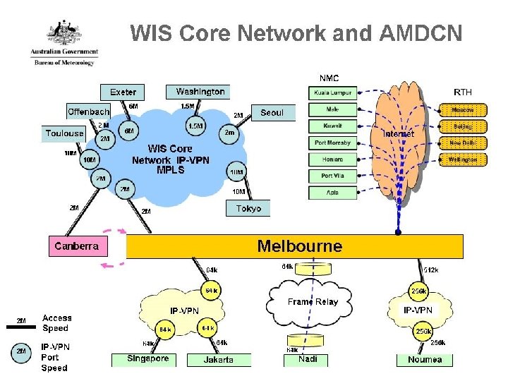
GISC Melbourne WIS Network • WIS Core Network connecting all GISC centres Main Telecommunication Network (MTN) in GTS terms. 4 centres (Tokyo, Exeter, Washington, Toulouse) connected. 2 centres (Offenbach, Seoul) soon to be connected • Area Meteorological Data Communication Network (AMDCN) Regional, Inter-regional and additional links (Regional Meteorological Telecommunication Network (RMTN) in GTS terms) consisting of IP-VPN, Frame Relay, Digital Subscriber Line (DSL) and internet • Melbourne is the only RTH centre on the MTN • Melbourne is the only designated Global Information System Centre (GISC) in RA-V, formally designated by EC in June 2012.
")
RA-V Regional Meteorological Telecommunication Network (RMTN)

WIS Development and Implementation in GISC Melbourne • 2006 - 2008 Participated in SIMDAT Project • 2007 Established WIS Project • 2008 Announced to WMO for its commitment to become a GISC • 2010 Joined Open. WIS Consortium • 2010 WMO Jump Start Visit by WMO WIS consultant • 2012 Participated in Open. WIS Installation Workshop in January Commenced Open. WIS installation and integration in May GISC audit by CBS ET-GDDP in June Formally designated by EC in June 2013 WIS Workshop to be conducted in April 2013 in Melbourne

Open. WIS Installation Open. WIS PORTAL Access / Follow Requests METADATA SERVICE Synchronization meta data Catalogue Access Harvesting DAR Catalogue Discover Browse Catalogue ADMINISTRATION Admin & Monitoring Administration SECURITY SERVICE DATA SERVICE Authorization Authentication Monitoring Collection 24 hour Cache User Store Replication Request Processing global data WIS Harnesses Internal System CMSS global data Dissemination (AIFS) Data Sources (RTDB, ADAM) outbound to users

Zones of Operation in Open. WIS
 Metadata Catalogue • RTH role • Update of Volume")
Discovery, Access and Retrieve (DAR) Metadata Catalogue • RTH role • Update of Volume C 1 on behalf of all Members in RA-V • Ad hoc and semi-annual update • Integrated with Message Switching Table • Migrating to DAR Metadata Catalogue • Automated and manual update of DAR in progress • RA-V Members notified of progress in Open. WIS • All RA-V Members nominated Melbourne as Principal GISC

Mutual Backup Arrangement with GISC Tokyo • GISC Tokyo and GISC Melbourne will mutually backup the essential GISC functions when either party has operational outages • GISC Tokyo and GISC Melbourne will consider backup services for all the DCPCs and NCs in our respective area of responsibility whenever possible • Essential GISC functions will include data exchange through conventional telecommunication networks and metadata management services • Details of backup functions, technical arrangements and schedules are to be agreed upon among relevant DCPCs or NCs and the two GISCs • GISC Tokyo and GISC Melbourne will take a step-by-step approach to the implementation of backup services that is practical and realistic


Thank you… With acknowledgement to Leon Majewski and contributions from staff across Research and Systems Division Dr Anthony Rea Acting Assistant Director Strategy, Parliamentary, International and Communication Australian Bureau of Meteorology a. rea@bom. gov. au
c843d0fa329dc6d763821e5d723fc77a.ppt