2b2cda9e64f9ba9baa9eae32cf5d31ca.ppt
- Количество слайдов: 23
 REDOSAT-RUN RE-Analysing Data Of SATellite imagery RSMC La RéUNion 2 nd International Best Tracks Archive for Data. Stewardship (IBTr. ACS) Workshop Honolulu 11 -13 April 2011 Thierry Dupont - RSMC La Réunion - Mars 2011
 Plan § § § § § Context Objectives of our re-analysis project over the South Indian Ocean What we really had in real-time before Hursat ? What we have now ? What we needed to start this re-analysis project? Downloading and dealing with the Hursat data Exemple of in-house built layers Methodology 1 st Step : To a purely « Dvorak based » Best-Track Methodology 2 nd Step : To a « final » Best-Track Planning of the project.
 Context – 6 th International Workshop on Tropical Cyclones (IWTC-VI) (Costa-Rica 2006) To study Tropical Cyclone activity and its eventual modifications in relationship with the global warming, it's primordial to work with "clean", high quality and "homogeneous" Tropical Cyclone databases. – Long-standing internal knowledge of the deficiencies of our cyclone database.
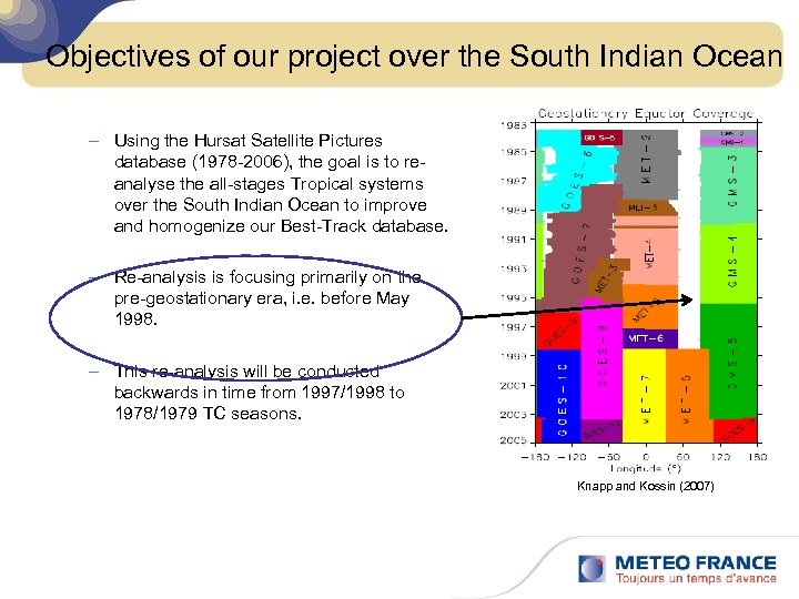 Objectives of our project over the South Indian Ocean – Using the Hursat Satellite Pictures database (1978 -2006), the goal is to reanalyse the all-stages Tropical systems over the South Indian Ocean to improve and homogenize our Best-Track database. – Re-analysis is focusing primarily on the pre-geostationary era, i. e. before May 1998. – This re-analysis will be conducted backwards in time from 1997/1998 to 1978/1979 TC seasons. Knapp and Kossin (2007)
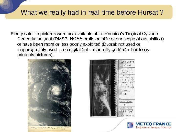 What we really had in real-time before Hursat ? Plenty satellite pictures were not available at La Reunion's Tropical Cyclone Centre in the past (DMSP, NOAA orbits outside of our scope of acquisition) or have been more or less poorly exploited (Dvorak not used or inappropriately used. . . no digital but « manually gridded » hardcopy printouts pictures).
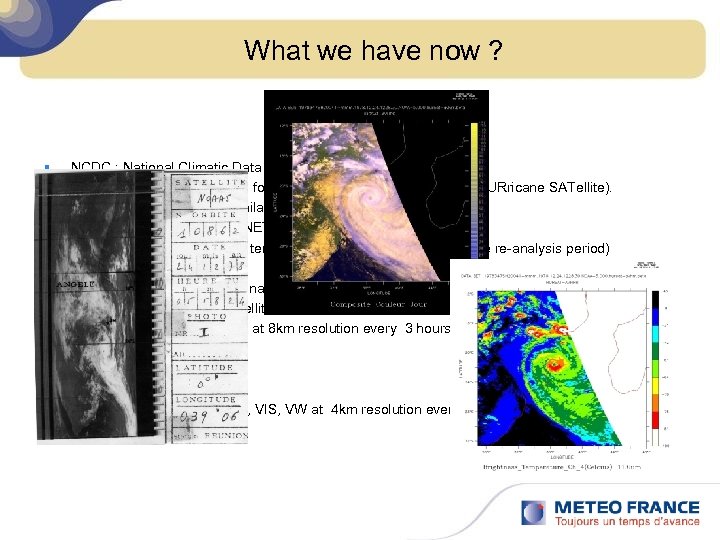 What we have now ? § NCDC : National Climatic Data Center (Asheville) – Digital Satellite Pictures focussed on Tropical Disturbances (HURricane SATellite). • Easy to get on available ftp server. • Standart format (NETCDF) • Calibrated without temporal bias (fixed resolution over the re-analysis period) – HURSAT-B 1 (International Satellite Cloud Climatology Project (ISCCP) B 1 ) : • Geostationary satellites. . – IR, VIS, VW at 8 km resolution every 3 hours – HURSAT-AVHRR : • Avhrr satellites – Channels IR, VIS, VW at 4 km resolution every 12 hours or more.
 What we needed to start this re-analysis project ? Geo-referenced Satellite Pictures: – We had to develop tools to convert and produce different channels and palettes pictures from Hursat Netcdf files (tools based on Ferret and Image. Magik). Visualization and Navigation – We adapted our in-house operational software and workstation Synergie-Cyclone. Tools and Technics for analysis – Dvorak Technique is daily used by all TC Specialists and Senior Forecasters of the re-analysis team. . – Some NWP models fields are also extracted for environmental conditions/parameters.
 Downloading and dealing with the Hursat data § First step is to identify systems and to link the SWIO and IBTr. ACS Nomenclatures (not obvious). § netcdf files are downloaded from eclipse ftp server. ftp: //eclipse. ncdc. noaa. gov/pub/hursat/ § netcdf files are locally converted (thanks to ferret macros) to layers which can be used by our in-house Synergie-Cyclone software. 1 Synergie-Cyclone Layer = 1 png pictures + 1 ascii georeferenced file.
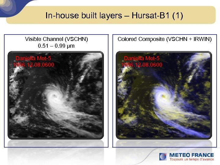 In-house built layers – Hursat-B 1 (1) Visible Channel (VSCHN) 0. 51 – 0. 99 μm Daniella Met-5 1996. 12. 08. 0600 Colored Composite (VSCHN + IRWIN) Daniella Met-5 1996. 12. 08. 0600
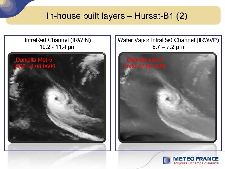 In-house built layers – Hursat-B 1 (2) Infra. Red Channel (IRWIN) 10. 2 - 11. 4 μm Daniella Met-5 1996. 12. 08. 0600 Water Vapor Infra. Red Channel (IRWVP) 6. 7 – 7. 2 μm Daniella Met-5 1996. 12. 08. 0600
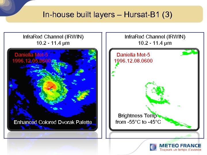 In-house built layers – Hursat-B 1 (3) Infra. Red Channel (IRWIN) 10. 2 - 11. 4 μm Daniella Met-5 1996. 12. 05. 0600 Enhanced Colored Dvorak Palette Infra. Red Channel (IRWIN) 10. 2 - 11. 4 μm Daniella Met-5 1996. 12. 08. 0600 Brightness Temp from -55°C to -45°C
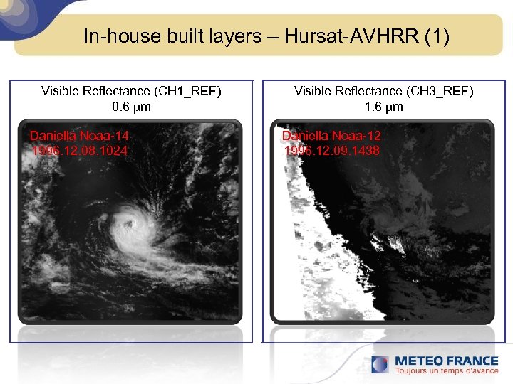 In-house built layers – Hursat-AVHRR (1) Visible Reflectance (CH 1_REF) 0. 6 μm Daniella Noaa-14 1996. 12. 08. 1024 Visible Reflectance (CH 3_REF) 1. 6 μm Daniella Noaa-12 1996. 12. 09. 1438
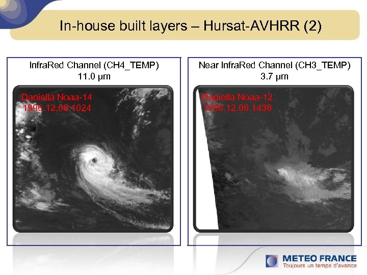 In-house built layers – Hursat-AVHRR (2) Infra. Red Channel (CH 4_TEMP) 11. 0 μm Daniella Noaa-14 1996. 12. 08. 1024 Near Infra. Red Channel (CH 3_TEMP) 3. 7 μm Daniella Noaa-12 1996. 12. 09. 1438
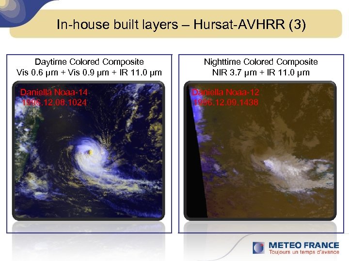 In-house built layers – Hursat-AVHRR (3) Daytime Colored Composite Vis 0. 6 μm + Vis 0. 9 μm + IR 11. 0 μm Daniella Noaa-14 1996. 12. 08. 1024 Nighttime Colored Composite NIR 3. 7 μm + IR 11. 0 μm Daniella Noaa-12 1996. 12. 09. 1438
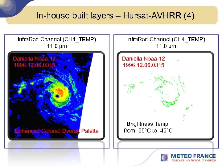 In-house built layers – Hursat-AVHRR (4) Infra. Red Channel (CH 4_TEMP) 11. 0 μm Daniella Noaa-12 1996. 12. 06. 0315 Enhanced Colored Dvorak Palette Infra. Red Channel (CH 4_TEMP) 11. 0 μm Daniella Noaa-12 1996. 12. 06. 0315 Brightness Temp from -55°C to -45°C
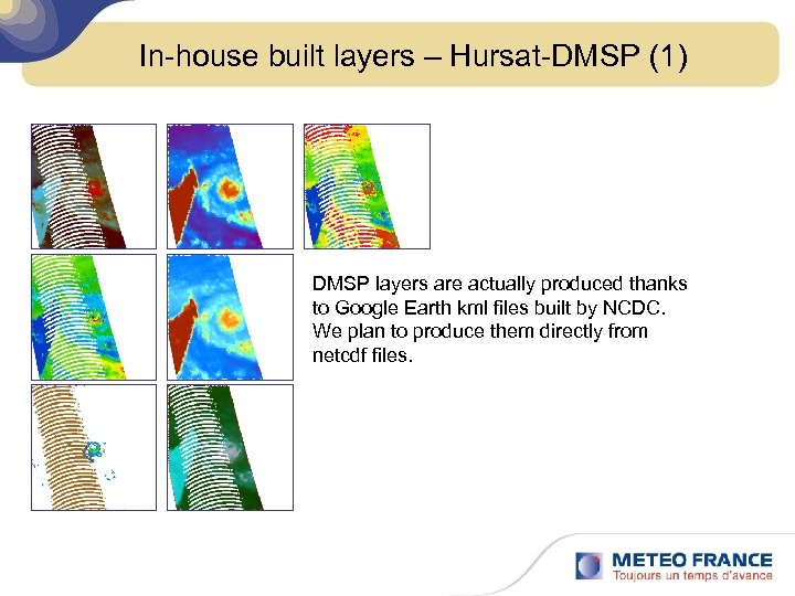 In-house built layers – Hursat-DMSP (1) DMSP layers are actually produced thanks to Google Earth kml files built by NCDC. We plan to produce them directly from netcdf files.
 Methodology 1 st Step : To a purely "Dvorak based" Best-Track § Each system to analyse is affected to a group formed with 3 TC Specialists/Senior Forecasters (2 groups). § Each analyst performs "blind" and independent analyses (only with the Dvorak technique) (Lat. Lon, confidence, T, CI, 10 mn Max. Wind, Gusts, Stormtype) and determines some empirical parameters, RMW, empirical extension of the gales). § When the 3 analysts end this first step, they meet together to build a synthetic and common purely "Dvorak based" Best. Track
 Methodology 2 nd Step : To a "final" Best-Track § Then the group will adjust the "Dvorak" BT with other available data, like microwave imagery, ECMWF SLP re-analysis fields and all generally sparse- available observations (we need to further investigate the ICOADS Ship database). § It results 2 BT – A purely "Dvorak based" Best. Track (for studies, comparison, homogeneous reference. . . ) – A "climatological" one.
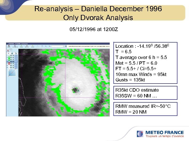 Re-analysis – Daniella December 1996 Only Dvorak Analysis 05/12/1996 at 1200 Z Location : -14. 19 S /56. 38 E T = 6. 5 T average over 6 h = 5. 5 Met = 5. 5 / PT = 6. 0 FT = 5. 5+ / Ci=5. 5+ 10 mn max Winds = 95 kt Gusts = 135 kt R 35 kt CDO estimate R 35 SW = 60 NM … RMW measured IR=-50°C RMW = 20 NM
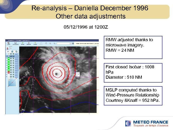 Re-analysis – Daniella December 1996 Other data adjustments 05/12/1996 at 1200 Z RMW adjusted thanks to microwave imagery. RMW = 24 NM First closed Isobar : 1008 h. Pa Diameter : 510 NM MSLP computed thanks to Wind-Pressure Relationship Courtney &Knaff = 952 h. Pa.
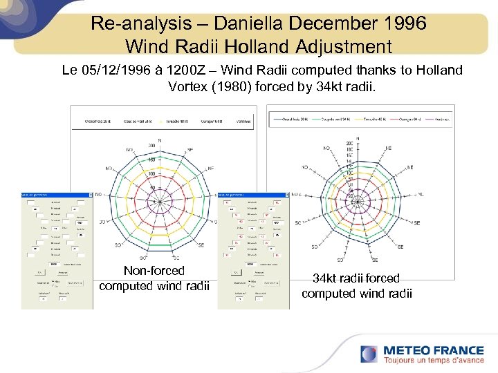 Re-analysis – Daniella December 1996 Wind Radii Holland Adjustment Le 05/12/1996 à 1200 Z – Wind Radii computed thanks to Holland Vortex (1980) forced by 34 kt radii. Non-forced computed wind radii 34 kt radii forced computed wind radii
 Redo. Sat-Run Planning of the project § May to October 2011 : Test of the re-analysis procedures and methodology with the TC season 1996/1997 (19 TCs over SWI + 7 TCs over SEI) § Then we plan to re-analyse 6 TC seasons each year, which means 3 seasons per group. § The whole period 1978 -1998 should be re-analysed in 3 to 4 years. Thierry Dupont - RSMC La Réunion - Mars 2011
 Thanks for your attention Merci de votre attention Thierry Dupont - RSMC La Réunion - Mars 2011


