690086fba812871084e8420c7215d486.ppt
- Количество слайдов: 121

Principles of generalisation Presented by: Koert Sijmons (GEOMAPA) Koert Sijmons 1

Contents (I) • Map generalisation – Introduction – Conceptual and graphic generalization • Guidelines for map generalisation – General guidelines: – Detailed Guidelines: built-up areas – Generalization exercise • Map Generalisation process – Sequence of map generalisation activities – Interrelation of map generalisation activities • Map generalisation in practice – Map production line of Dutch topographic survey (TDKadaster) Koert Sijmons 2

Contents (II) • Automatic generalisation – Line simplification exercise – Generalisation approach: ladder, star or combined – Model and cartographic generalisation – Sequential processing for model generalisation – Generalisation operators – Process model for the generalisation of buildings (example) – Clustering of buildings for aggregation and typification • Automatic generalisation using Arc. GIS – Vector generalisation tools in Arc. GIS • Generalisation exercises – Automatic generalisation of Land Use polygons (Arc. GIS) – Compilation model for a Route map Koert Sijmons 3

Map generalisation Koert Sijmons 4

Why is generalisation necessary? If a map is produced from a database at a scale smaller than intended, the map might become illegible. The data requires Generalisation Koert Sijmons 5

Generalization from large into small scale Scale 1: 25, 000 Scale 1: 50, 000 1 cm = 100 meters 1 cm = 250 meters 1 cm = 500 meters Scale 1: 100, 000 Scale 1: 200, 000 Scale 1: 500, 000 1 cm = 1 kilometer 1 cm = 2 kilometer 1 cm = 5 kilometer Increase of area Decrease of detail Scale 1: 10, 000 Koert Sijmons 6

Absolute minimum dimensions of graphic elements (point, line, area) 0. 05 mm Black line 0. 08 -0. 1 mm Colored line 0. 15 mm Line separation 0. 25 mm Separation of colored lines Diameter of circle 0. 15 mm 0. 3 x 0. 3 mm Square 0. 2 mm 2 4. 0 mm Area separation Dimensions for colored areas Koert Sijmons 7

Scale reduction without generalisation 1: 25, 000 map reduced to 50% without generalisation 1: 25, 000 map reduced to 25% without generalisation Koert Sijmons 8

Landscape, versus Cartographic Model Digital Landscape Model (DEM) Digital Cartographic Model (DEM) Polygon (x, y) 1200 Line (x, y) PT 1289 Line (x, y, z) Point (x, y) - Objects, (point, line and area) - X, Y, Z, Coordinates - Attributes - Without scale Scale 1: 25, 000 Koert Sijmons 9

Why is generalisation necessary? – Increased density of the map contents due to scale reduction. – Features become too small to be seen clearly, or to be represented at true size (to scale) on a monitor or on paper. Koert Sijmons 10

What is generalization? The process of reducing the amount of detail in a map (or database) in a meaningful way • Generalization related to the map purpose - Generalisation is scale related - Generalization is partly subjective - Generalization is output related Koert Sijmons 11

Map purpose Topographic map scale 1: 100, 000 Wall map scale 1: 100, 000 Koert Sijmons 12

Generalisation is partly subjective Koert Sijmons 13

Generalisation activities are scale related • On large scale maps the real world can be represented with large detail. Such maps require only little generalisation: some simplification, some enlargement or some displacement of features. • • However, the smaller the scale of the map, the less detail can be represented, the more important generalisation becomes. Koert Sijmons 14

Generalisation (example) Generalised map represented at scale 1: 10, 000 Koert Sijmons 15

Generalisation activities are scale related Koert Sijmons 16

Generalising activities are scale related • Where does generalisation really begin? • Scales ≥ 1: 5, 000: the planimetric accuracy of the original survey data are fairly well maintained. • Scales 1: 10, 000 – 1: 25, 000: some roads and other features (e. g. railways) are no longer true to scale. Some simplification, enlargement or displacement of features. • Scales 1: 25, 000 – 1: 50, 000: roads and buildings are no longer true to scale (roads are represented by lines). Buildings are often simplified and displaced. In densely built-up areas buildings are already omitted or combined. Koert Sijmons 17

Generalising activities are scale related • Scales ≤ 1: 50. 000: – Selection, reclassification and resymbolisation; – Strong simplification and displacements; – Buildings no longer true to scale or not shown as individual buildings; – Merging of area features. Koert Sijmons 18

Generalisation (example) Result after a scale reduction Topographic Map 1: 50 000 after generalisation Topographic Map 1: 10 000 Koert Sijmons 19

Conceptual and graphic generalisation Conceptual generalisation: selection/omission of categories, (re)classification, (re)symbolisation or the enhancement of objects. It mainly effects the semantics (attributes) of the data. The map legend changes. Graphic generalisation: simplification, enlargement, displacement, or the graphic combination or selection of objects. It mainly effects the geometry and location of the objects. Koert Sijmons 20

Conceptual generalization activities: Selection (omission) of categories Classification Symbolization Enhancement (emphasis) Koert Sijmons 21

Graphic generalization activities: Selection (omission) Merging (combination or aggregation) Simplification Enlargement (exaggeration) Displacement Koert Sijmons 22

Conceptual versus graphic generalisation Koert Sijmons 23

Generalization activities: graphic selection symbolisation conceptual selection displacement classification merging simplification enhancement Koert Sijmons 24

Question 1 Koert Sijmons 25

Question 2 Koert Sijmons 26

Question 3 Koert Sijmons 27

Question 4 Koert Sijmons 28

Guidelines for map generalisation Koert Sijmons 29

General guidelines (I) l select those features that are necessary or useful for the purpose of the map and in accordance to the scale. Emphasise the most important features and omit or repress the less important ones; l have regard for the displacement priority rules; l have regard for the minimum sizes of graphic map symbols; l within the limitations imposed by the map scale, planimetric accuracy should be maintained. Koert Sijmons 30

Important and less important features J L Koert Sijmons 31

Emphasise important and repress less important features L J Koert Sijmons 32

Emphasize the administrative hierarchy L J Koert Sijmons 33

Priority rules for the displacement* • • • Trigonometric points Hydrography features Railways Roads Buildings Area features, e. g. forests Koert Sijmons 34

Minimum sizes of point symbols: Paper (example) Koert Sijmons 35

Minimum sizes of point symbols: WEB (example) Koert Sijmons 36

Minimum sizes of symbols: WEB Refer to what you can see on the monitor at a 100% zoom. Minimum sizes on a monitor may be about three times larger, because of the lower resolution of the screen. Note: size of 1 pixel is approximately 0. 3 mm Koert Sijmons 37

General guidelines (II) l retain important and noticeable features. For example isolated buildings in a rural area will often be retained on medium scale maps because of their importance in the area; l within the limitations imposed by the map scale, shape of features and the character of the area should be maintained. For example if an area is characterised by numerous small rivers and lakes and forest areas, this should also be clear at smaller scales; Koert Sijmons 38

L J Koert Sijmons 39

General guidelines (III) l relationships between features should be taken into account. For example there is a close relationship between relief (e. g. contours) and hydrography. After generalisation the contours should still fit to the river system. The size of buildings in built-up areas should be in relation to open areas and the width of streets. l be consistent Koert Sijmons 40

Contours should fit to streams Koert Sijmons 41

Genereralisation example Combined application of the basic rules Koert Sijmons 42

Detailed Guidelines built-up areas Koert Sijmons 43

Change of symbol typification • at large scales, individual buildings • at smaller scales, built-up area symbol for the larger urban areas • at very small scales, (small) settlements shown by point symbols Koert Sijmons 44

Buildings at 1: 200 000 Koert Sijmons 45

Generalisation: built-up areas • points to watch in graphic representation – Minimum dimension and distances – Shapes – Special buildings – Maintain structure: density, size differences, orientation, characteristic shapes – Displacement of buildings along roads – Maintain relative location Koert Sijmons 46

Minimum dimension and distances Koert Sijmons 47

Minimum dimension and distances Koert Sijmons 48

Shapes Koert Sijmons 49

Shapes Koert Sijmons 50

Special buildings Koert Sijmons 51

Special buildings / other constructions Koert Sijmons 52

Structure: density Koert Sijmons 53

Structure: size differences Koert Sijmons 54

Structure: orientation Koert Sijmons 55

Structure: characteristic shapes Koert Sijmons 56

Detailed solutions Koert Sijmons 57

Example Koert Sijmons 58

Generalisation exercise Koert Sijmons 59

Generalisation exercise Koert Sijmons 60

Map generalisation process Koert Sijmons 61

Sequence of map generalization activities Conceptual generalisation – Selection of object categories – Reclassification of objects – Resymbolisation of objects • Assign symbols to the object geometry (this includes object enhancement) Graphic generalisation – Object aggregation – Object exaggeration (be aware of minimum sizes) – Object displacement (be aware of displacement order) – Object selection/omission – Object simplification • Name placement Koert Sijmons 62

Sequence of map generalization activities • Conceptual generalisation: 1. Conceptual selection: extraction of purpose and scale adapted objects or group of objects based on database attributes. Reclassification: reclassify objects into another category to enable aggregation with objects having the same class. Resymbolisation: geometry type change (includes collapses a polygon either to a line or to a point) 2. 3. • Assign symbols to the object geometry • Graphic generalisation: • • • Aggregation: combine objects of the same or a similar class to a new object Exaggeration: enlarges objects Displacement: displace objects in conflict situations Deletion: removes an objects Simplification: form of the lines and area outlines • Name placement: optimize the placement of names Koert Sijmons 63

Interrelation of generalization activities • You can subdivide generalization into a several sets of processes. However the processes usually interrelate. One process is often required as a result of another process. • For example: • Houses along a road need to be displaced when a road has to be enlarged in order to remain visible after scale reduction Koert Sijmons 64

Map generalization in practice Koert Sijmons 65

Map production line of TDKadaster (Dutch Topographic Survey) Koert Sijmons 66

TOP 10 vector Topographic map 1: 25. 000 Koert Sijmons 67

Production of TOP 50 vector TOP 10 vector Koert Sijmons 68

TOP 50 vector Topographic map 1: 50. 000 Koert Sijmons 69

Production line (cont…) Koert Sijmons 70

Topographic map 1: 100. 000 Topographic map 1: 250. 000 Koert Sijmons 71

Example: generalisation flow in Germany Koert Sijmons 72

Example: generalisation flow in France Koert Sijmons 73

Koert Sijmons 74

Automatic generalisation Koert Sijmons 75

Line simplification exercise Generalise this map of the England & W - reduce the existing 66 points to maximum - only use existing points - only use straight lines Koert Sijmons 76

Line simplification exercise Koert Sijmons 77

Generalisation workflow Combined approach Customer defined output Master database 1: 250 000 output 1: 1 000 output 1: 50 000 1: 10 000 output 1: 50 000 output Koert Sijmons 78

Real world Object generalisation DLM 1: 10 000 Model (database) generalisation DLM 1: 50 000 Cartographic generalisation DCM 1: 50 000 Map (analog model) Koert Sijmons 79

From DLM to DCM DLM DCM “GIS database” “Map database” Koert Sijmons 80

Model generalisation • Reduces the amount of data to the level suitable for the target scale. (a) selection of objects by class and by attribute value and/or context (b) reclassification (c) geometry-type changes (incl. collapsing) (d) aggregation (e) typification (optional) (f) deletion (g) geometric simplification (as long as it does not create conflicts among features due to significant displacement of features) • None of the above operations displace objects (or a set of objects) and hence the objects remains in its correct location. Koert Sijmons 81

Cartographic generalisation • How to make best use of map space to optimize legibility at a given scale and for a particular purpose of the map. • Involved operations: • • • Applying map-specific representations Displacement of objects in conflict situations Name placement Koert Sijmons 82
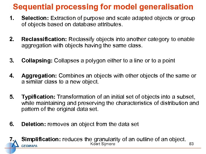
Sequential processing for model generalisation 1. Selection: Extraction of purpose and scale adapted objects or group of objects based on database attributes. 2. Reclassification: Reclassify objects into another category to enable aggregation with objects having the same class. 3. Collapsing: Collapses a polygon either to a line or to a point 4. Aggregation: Combines an objects with other objects of the same or a similar class to a new object. 5. Typification: Transformation of an initial set of objects into a subset, while maintaining and preserving the characteristics of distribution and pattern of the original data set. 6. Deletion: removes an object from the data set 7. Simplification: reduces the granularity of an outline of an object. Koert Sijmons 83

Generalisation operators (I) Koert Sijmons 84

Generalisation operators (II) Koert Sijmons 85

Application of Generalization operators Aggregate buildings avoiding streets Simplify buildings Collapse doubleline roads to centerlines Aggregate polygons Displace buildings from roads Displace linear features Koert Sijmons 86
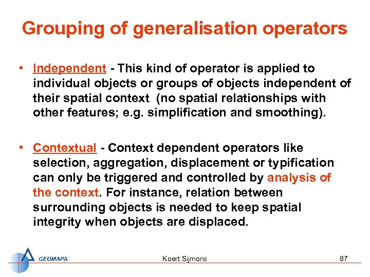
Grouping of generalisation operators • Independent - This kind of operator is applied to individual objects or groups of objects independent of their spatial context (no spatial relationships with other features; e. g. simplification and smoothing). • Contextual - Context dependent operators like selection, aggregation, displacement or typification can only be triggered and controlled by analysis of the context. For instance, relation between surrounding objects is needed to keep spatial integrity when objects are displaced. Koert Sijmons 87

Context dependent operation: aggregation (I) • In automated process of model generalisation all single ponds would be eliminated (each one is too small) • To represent the „style“ of landscape correctly, they have to be „typically“ aggregated Koert Sijmons 88
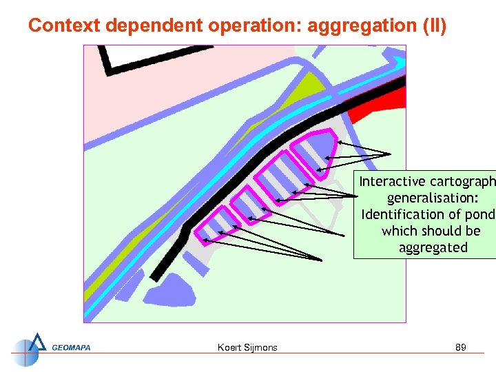
Context dependent operation: aggregation (II) Interactive cartograph generalisation: Identification of ponds which should be aggregated Koert Sijmons 89
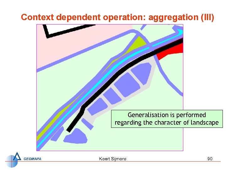
Context dependent operation: aggregation (III) Generalisation is performed regarding the character of landscape Koert Sijmons 90

Example of a process model for the generalization of buildings Koert Sijmons 91

Clustering of buildings for aggregation Koert Sijmons 92

Example of building aggregation Koert Sijmons 93

Sub clustering of buildings for typification Koert Sijmons 94
Automatic generalisation The structured data in a database, in ‘layers’ or object classes with attributes, are highly suited to the requirements of conceptual generalisation (e. g. it is easy to select or omit certain categories, or reclassify the data). – Graphic generalisation is another story. No fully automated systems exist yet, but software has been created to perform some of the tasks – Functional breakdown of the generalisation process is important in automatic generalisation Koert Sijmons 95
Automatic generalization using Arc. GIS Koert Sijmons 96
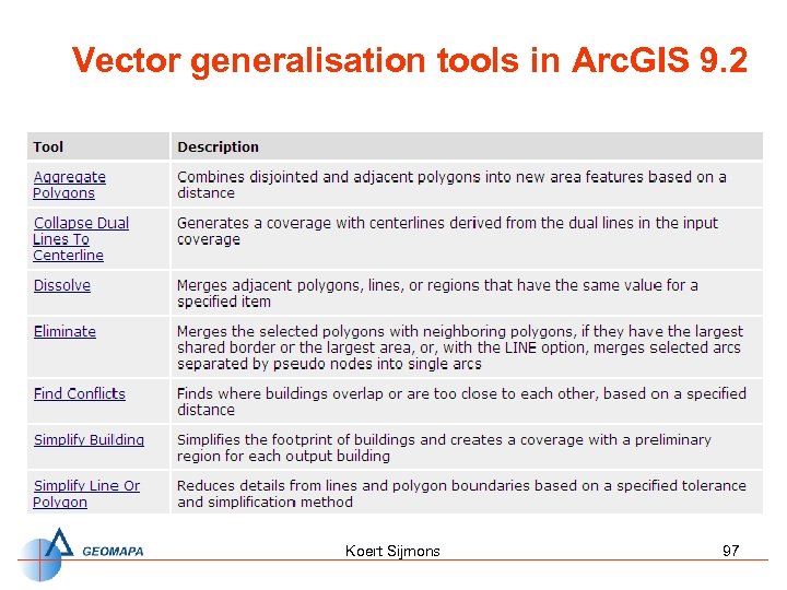
Vector generalisation tools in Arc. GIS 9. 2 Koert Sijmons 97
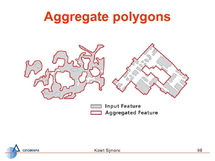
Aggregate polygons Koert Sijmons 98

Create Centrelines Koert Sijmons 99
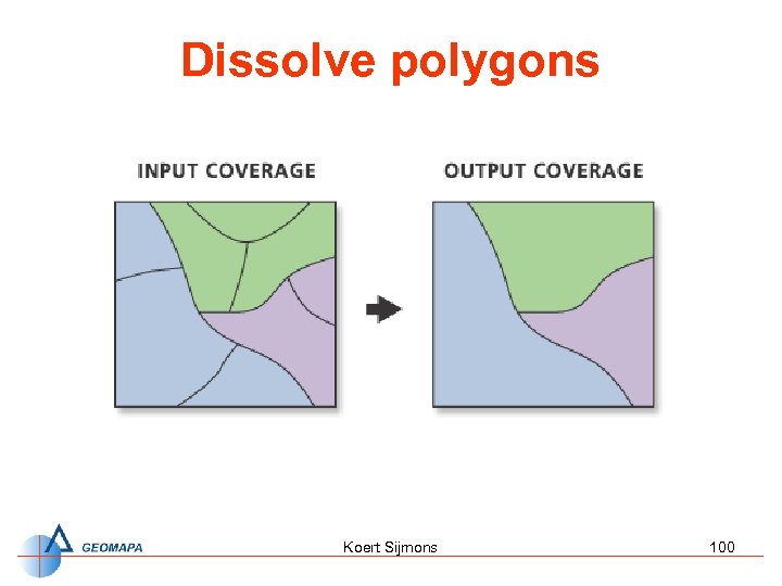
Dissolve polygons Koert Sijmons 100

Eliminate polygons Koert Sijmons 101

Finding building conflicts Koert Sijmons 102
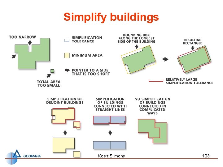
Simplify buildings Koert Sijmons 103

Simplify lines Koert Sijmons 104
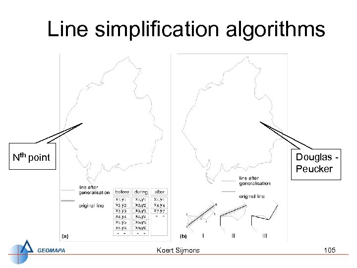
Line simplification algorithms Nth point Douglas Peucker Koert Sijmons 105

Line simplification Douglas - Peucker algorithm Koert Sijmons 106
Demonstration Arc. GIS & Map. Shaper • Demo of Point Remove/Bend simplify tool with Arc. GIS and the Map. Shaper tool http: //mapshaper. org/ Koert Sijmons 107

Smooth lines Koert Sijmons 108

Spatial Analyst Generalization toolset Koert Sijmons 109
Generalisation exercises 1. Automatic generalisation of Land Use polygons (Arc. GIS 9. 2) 2. Compilation model for Route map Koert Sijmons 110

Exercise 1 • Automatic generalisation of Land Use polygons (Arc. GIS 9. 2) ü ü ü • Reclassification of the polygons (tool: dissolve) Omission of small polygons (tool: eliminate) Simplification of the polygons (tool: simplify polygon) Task: Automatic Generalization of Countries Boundaries ü Generalise the countries boundaries of the ESRI World data set, in order to use them for the design of a small scale web map of Africa (e. g. 1: 50 M). ü Create a process model for the generalization (optional) Koert Sijmons 111

Simplification of the polygons (tool: simplify line) with Arc. GIS 9. 1 Land use polygons tool: polygon to line Land use lines tool: simplify line Simplified Land use lines tool: line to polygon Simplified Land use polygons Koert Sijmons 112
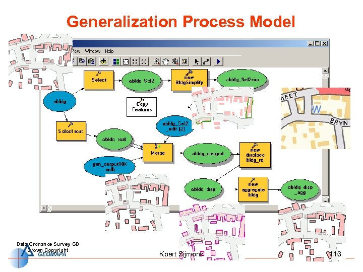
Generalization Process Model Data Ordnance Survey GB Crown Copyright Koert Sijmons 113

Thank’s for your attention ! Koert Sijmons 114

http: //mapshaper. org/ Koert Sijmons 115
Koert Sijmons 116

Koert Sijmons 117
Koert Sijmons 118
Koert Sijmons 119

Koert Sijmons 120

Koert Sijmons 121
690086fba812871084e8420c7215d486.ppt