

d9df1513bf3aa129cb8593f43fc18bee.ppt
- Количество слайдов: 37
 Preliminary Hotspot Identification Implementing a Resilience Framework to Support Climate Change Adaptation in the Mt Elgon Region Of the Lake Victoria Basin Thomas J Ballatore, T. J. & Shisanya, C. A.
 What do we mean by “hotspot” • My first thought was landslides • But the project is focused on climate change adaptation • How do we balance “local” vs. “lake basin” scale questions in the project?
 • Population (Ugandan census 2002, Kenyan census") Data available now • Administrative areas (GADM) • Population (Ugandan census 2002, Kenyan census 2009, Landscan 2008) • Elevation data (slope, flow direction) • Land Use/Land Cover (Landsat) • Soil (Harmonized World Soil Database) • Climate (World. Clim, TRMM)
Data available now • Administrative areas (GADM) • Population (Ugandan census 2002, Kenyan census 2009, Landscan 2008) • Elevation data (slope, flow direction) • Land Use/Land Cover (Landsat) • Soil (Harmonized World Soil Database) • Climate (World. Clim, TRMM)
 Administrative Areas • From GADM, we have seemingly very accurate boundaries all the way down to parish level in Uganda and sublocation level in Kenya. • I believe both were generated as part of some international projects in the past 10 years. • The names and locations also seem to include all the recent changes, esp. at the Ugandan level.
 Population • I downloaded the Uganda 2002 and Kenya 2009 census raw data and input it into the administrative polygons. • Population density is shown below. The white part inside is Mt. Elgon NP. The white parts surrounding areas for which I haven’t input the data yet.
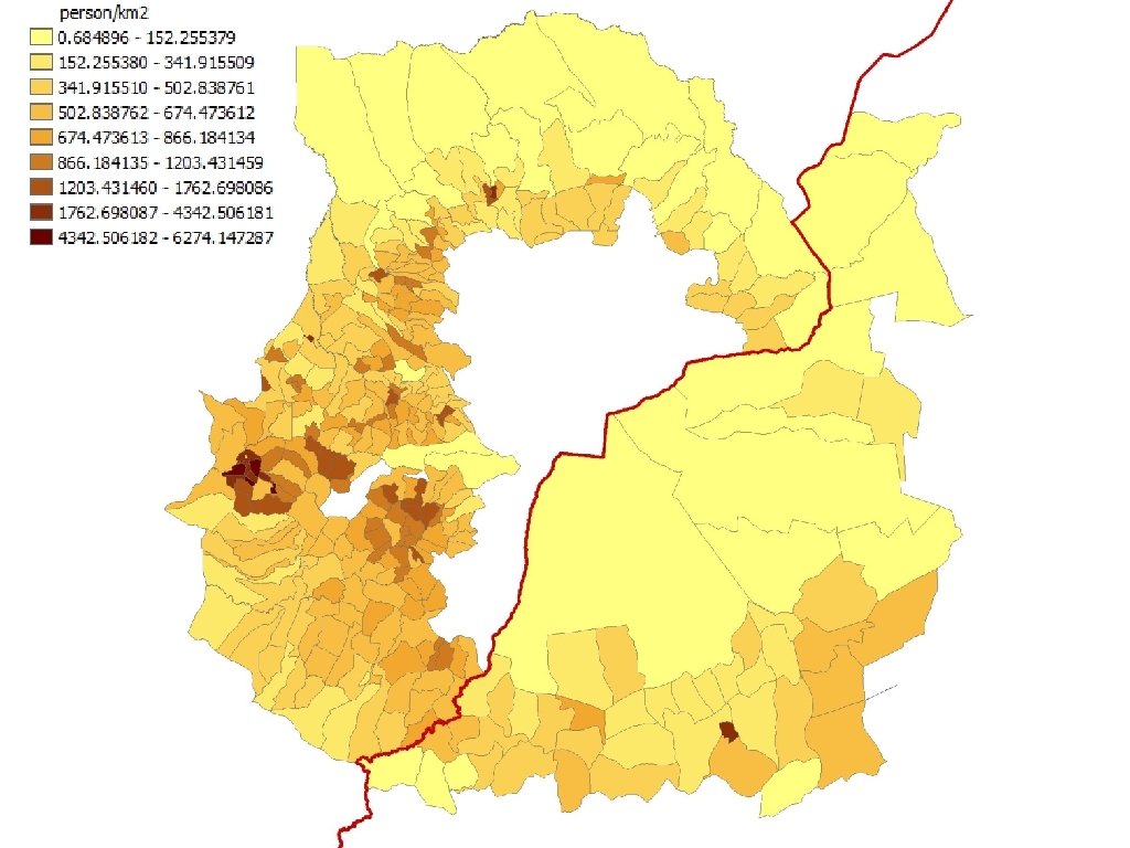
 • I usually use the Land. Scan dataset (2008) but it") Population (cont. ) • I usually use the Land. Scan dataset (2008) but it shows LOTS of people inside the park. • I wouldn’t be surprised if the official census data purposely did not list people in the park (illegal? ) but… • Many of the people are living at 3500 m+ with ave. T of 6 C…I can’t believe that and assume Landscan is wrong. (I’d like to buy the 2011 data)
Population (cont. ) • I usually use the Land. Scan dataset (2008) but it shows LOTS of people inside the park. • I wouldn’t be surprised if the official census data purposely did not list people in the park (illegal? ) but… • Many of the people are living at 3500 m+ with ave. T of 6 C…I can’t believe that and assume Landscan is wrong. (I’d like to buy the 2011 data)
 Park boundary might be slightly wrong but this area is a problem for Landscan
 DEM for topography (for basin delineation,") DEM • I used SRTM 3 (~90 m) DEM for topography (for basin delineation, flow direction and slope). • I might try GDEM (~30 m) but it generally is of poorer quality than SRTM 3.
DEM • I used SRTM 3 (~90 m) DEM for topography (for basin delineation, flow direction and slope). • I might try GDEM (~30 m) but it generally is of poorer quality than SRTM 3.
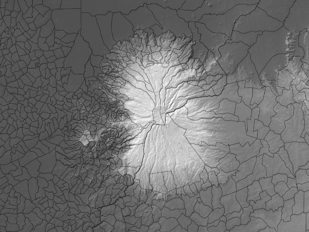
 Elevation with Shaded Relief
 Slope
Slope
 Soil • It seems the Harmonized World Soil Database information might be a good start. • It has lots of parameters and what appears to be a good spatial resolution. • During the project, if we can get better soil maps from Uganda/Kenya, we can use those.
 Soil Types
") Soil Types (in landslide areas)
Soil Types (in landslide areas)
 Land Use/Land Cover change • Landsat dates back farthest but is only 30 m resolution. • If possible, it would be great if we could purchase one of the higher resolution images from perhaps World. View-2. • One problem is that the western flank of Elgon is often covered in clouds although I have found a few cloud-free images.
 RS: Land Use/Land Cover Change Landsat MSS, 01 February 1973
 RS: Land Use/Land Cover Change Landsat ETM+, 04 February 2012
 Climate • Below are the Annual average T and P for 1950 -2000 from the downscaled (~1 km) World. Clim dataset
") Precipitation (1950 -2000 annual ave. )
Precipitation (1950 -2000 annual ave. )
") Temperature (1950 -2000 annual ave. )
Temperature (1950 -2000 annual ave. )
 • We might also make use of “real-time” TRMM data if") Climate (cont. ) • We might also make use of “real-time” TRMM data if precipitation gauges aren’t available. • The following show rainfall before a major landslide event (see yellow polygons) on 25 Jun 2012.
Climate (cont. ) • We might also make use of “real-time” TRMM data if precipitation gauges aren’t available. • The following show rainfall before a major landslide event (see yellow polygons) on 25 Jun 2012.
 TRMM Rainfall Estimate: 21 June 2012
 TRMM Rainfall Estimate: 22 June 2012
 TRMM Rainfall Estimate: 23 June 2012
 TRMM Rainfall Estimate: 24 June 2012
 TRMM Rainfall Estimate: 25 June 2012
 Identifying landslide hotspots • Surely, someone has done this before! • I need to go trough all the literature and past project documents.
 Identifying landslide hotspots • What do we need to know to predict future landslides? • Best is to know where and under what conditions past landslides have occurred. • I’ve mapped four major landslides that appeared in the news (1997, 1 Mar 2010, 29 Aug 2011, and 25 Jun 2012)
 Some Landslide Locations
 Some Landslide Locations Bumwalukani, 26 June 2012 Namasheti, 01 March 2010
 view of Bumwalukani Landslide Bumwalukani, 26 June 2012") Landsat (17 Oct 2012) view of Bumwalukani Landslide Bumwalukani, 26 June 2012
Landsat (17 Oct 2012) view of Bumwalukani Landslide Bumwalukani, 26 June 2012
") Google Earth View (yellow pin is start)
Google Earth View (yellow pin is start)
 Identifying landslide hotspots • Common factors seem to include: • High slope • Intensive land cover change • High precipitation • (Not clear on role of soil type yet)
 Identifying landslide hotspots • We could do an GIS-based analysis to find other areas with common characteristics. • Naturally, areas with population downslope would be most important to identify.
 “Hotspots” in the broader framework • Much of the LULC change will be affecting the downstream lake basins • Increased sediment load • Changed hydrology • Role of changing climate in all these factors?
 Lake Basins Lake Turkana Drainage Basin Lake Kyoga Drainage Basin Lake Victoria Drainage Basin UGANDA KENYA