

7a2cf15456c5416ab7cf570b7fed5cfa.ppt
- Количество слайдов: 37
") PHYSICAL GEOGRAPHY OF THE MIDDLE EAST (N. AFRICA, SW ASIA)
PHYSICAL GEOGRAPHY OF THE MIDDLE EAST (N. AFRICA, SW ASIA)
 SEAS & PENINSULAS: ARABIAN PENINSULA Separated from Africa by Gulf of Aden & Red Sea Sinai Pen. & Suez Canal separate the land to the north & west Persian Gulf is on the east side Gulf of Aden
 SEAS & PENINSULAS: ANATOLIA Bosporus Strait Aegean Sea ANATOLIA ›Bordered by the Black Sea to North, Aegean Sea to West and the Mediterranean Sea to South ›Many straits connecting seas lots of trade ($)
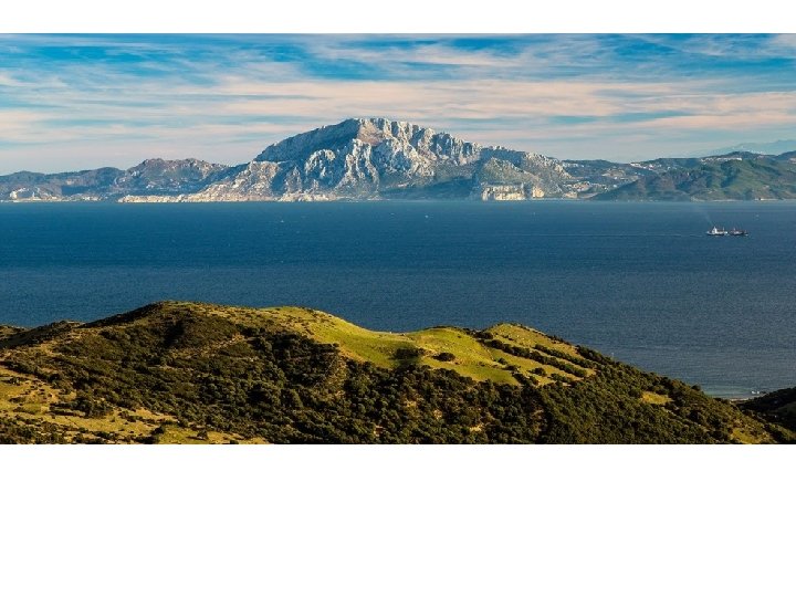
 SEAS & PENINSULAS Strait of Gibraltar Separates Africa from Iberian Pen. Only 8 -9 miles or so wide Known as ‘gateway to Africa’
 STRAIT OF GIBRALTAR
 SEAS & PENINSULAS Strait of Hormuz If sanctions put on Iran oil, strait would be cut off (some deny threat of sanctions) ~ 30% of world’s oil trade
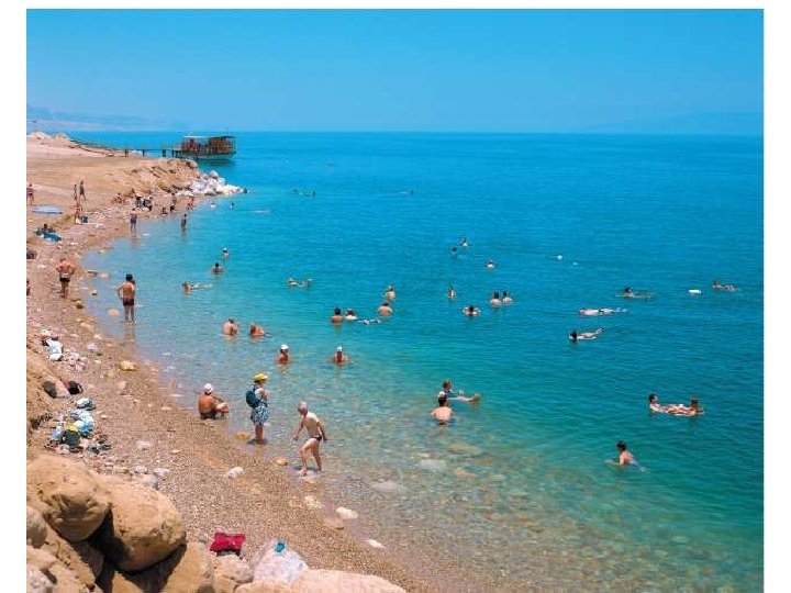
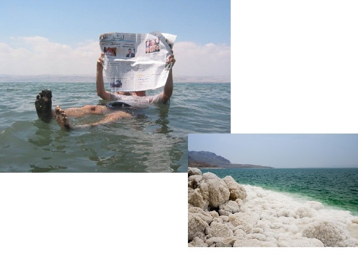
 › 9") SEAS & PENINSULAS: DEAD SEA ›On Jordan River (borders Jordan & Israel) › 9 X saltier than any ocean ›In the 50 s L= 262 m, W= 57 m ›Today L= 42 m, W= 11 m What does this The Dead Sea is heavily impacted by mean? Desertification—it is shrinking
SEAS & PENINSULAS: DEAD SEA ›On Jordan River (borders Jordan & Israel) › 9 X saltier than any ocean ›In the 50 s L= 262 m, W= 57 m ›Today L= 42 m, W= 11 m What does this The Dead Sea is heavily impacted by mean? Desertification—it is shrinking
 fight over water rights") The Jordan River Israel & Jordan (and others in area) fight over water rights
The Jordan River Israel & Jordan (and others in area) fight over water rights
 ›But it is") SEAS & PENINSULAS Caspian Sea ›Largest inland/landlocked body of water (lake) ›But it is salt water!! (remnants of larger sea) ›Facing increased evaporation & irrigation/industry uses, but a decrease in flow from feeder rivers
SEAS & PENINSULAS Caspian Sea ›Largest inland/landlocked body of water (lake) ›But it is salt water!! (remnants of larger sea) ›Facing increased evaporation & irrigation/industry uses, but a decrease in flow from feeder rivers
 SEAS & PENINSULAS Aral Sea Use to be large & have productive fishing Shrunk drastically due to USSR draining it for irrigation How to adapt? Build dams to provide irrigation
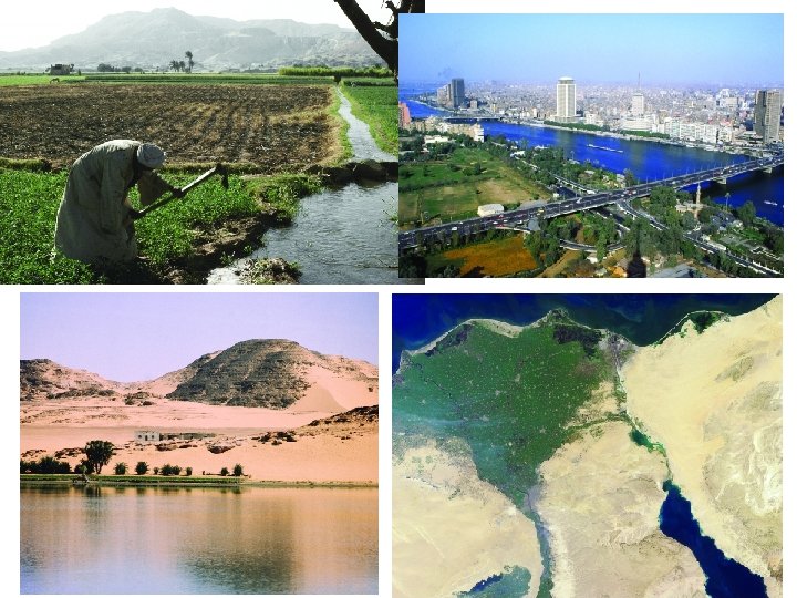
 RIVERS Nile River Aswan High Dam Longest in world Flows NORTH to Med. Sea 90% of Egyptians live in delta or along river (= 3% of land) Faces great flood seasons built Aswan High Dam for control, but it limits alluvial soil
 Aswan High Dam Hydroelectric Power Plant along the Nile River; also provides fish
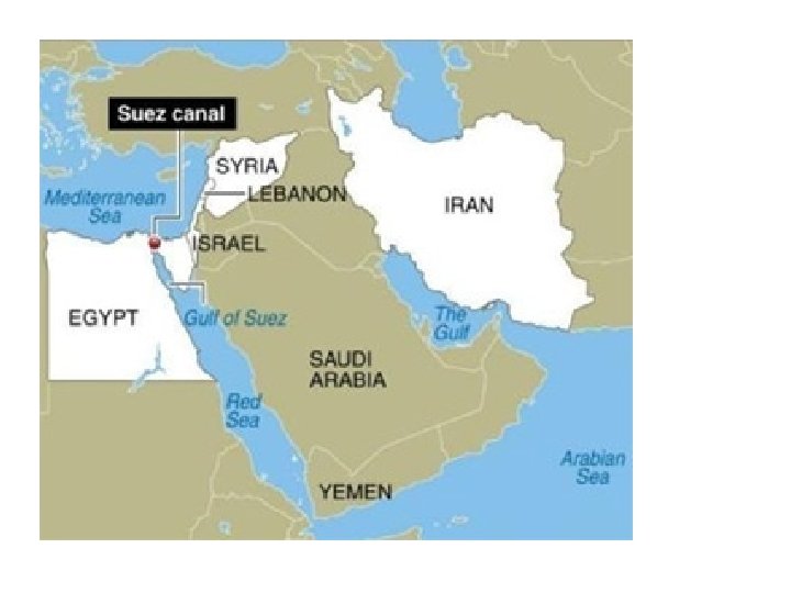
 Suez Canal Man-made canal; completed by the British in 1869 Links the Mediterranean & Red Seas!
 RIVERS Tigris & Euphrates Mesopotamia or “land between two rivers” aka Fertile Crescent Join to form Shatt al Arab Border of Iraq & Iran Wars & treaties over it
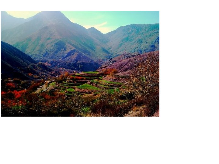
 RIVERS Wadi in Oman Wadis- dry streambeds that will fill with heavy rain flash floods (seasonal) Since they are typically arid, creates mud quickly dangerous mud flows
 PLAINS, PLATEAUS, & MTNS. Since most is desert/steppe agricultural base = coastal areas of Med. Sea, Caspian Sea, & Persian Gulf Atlas Mountains Longest mountain range Stretches from Morocco to Algeria Northern side of Atlas allows for lots of agriculture (farms, fishing, livestock) Rainy side, Mediterranean climate
 PLAINS, PLATEAUS, & MTNS. Hejaz & Asir ›West coast of Arabian Pen. ›Some rainshadow effect to Central Plateau Caucasus Mtns ›b/w Black & Caspian Sea ›Seen as border b/w European Russia & Asia
 Mountain Ranges in Mid-East Elburz Mts. , Iran Zagros Mts. , Iran Taurus Mts. , Turkey
 Black sand desert, covers 70% of Turkmenistan Qizilqum") PLAINS, PLATEAUS, & MTNS. Garagum (Karakum) Black sand desert, covers 70% of Turkmenistan Qizilqum (Kyzyl Kum) Red sand desert in Uzbekistan & Kazakhstan Use wide spaces for livestock
PLAINS, PLATEAUS, & MTNS. Garagum (Karakum) Black sand desert, covers 70% of Turkmenistan Qizilqum (Kyzyl Kum) Red sand desert in Uzbekistan & Kazakhstan Use wide spaces for livestock
 Desert Bedouins
 Fresh Groundwater Sources
 Desalinization Plants
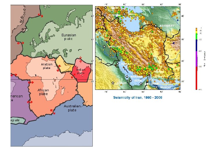
 TECTONIC ACTIVITY Meeting point of the African, Arabian, & Eurasian plates Reason for mountainous terrain Many earthquakes Iran has 90% of land on faults Landforms still changing Red Sea--expanding
 & nat. gas are region’s most abundant resources 70% of") NATURAL RESOURCES Oil (petroleum) & nat. gas are region’s most abundant resources 70% of world’s oil found here 33% of world’s nat. gas reserves found here Reserves are still being discovered! WWII sparked production as we moved to modern industry/reliance
NATURAL RESOURCES Oil (petroleum) & nat. gas are region’s most abundant resources 70% of world’s oil found here 33% of world’s nat. gas reserves found here Reserves are still being discovered! WWII sparked production as we moved to modern industry/reliance
 The Natural Resources of the Middle East
 World Oil Reserves
") Persian Gulf Oil Exports (2003)
Persian Gulf Oil Exports (2003)
 Leading U. S. Oil Suppliers The U. S. imports 30% of its oil needs from the Middle East.
 NATURAL RESOURCES Completed Dubai Tower Prob w/ oil dependence b/c economy stability fluctuates as oil prices fluctuate Many countries are now diversifying UAE banking, info. tech, tourism Libya infrastructure, fisheries