e66b244868fb45c3c8f05a7ddeda5b76.ppt
- Количество слайдов: 33
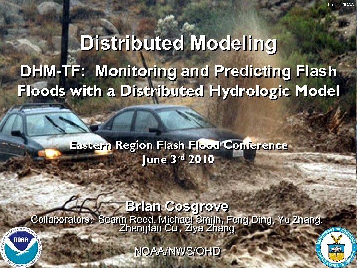
Photo: NOAA Distributed Modeling DHM-TF: Monitoring and Predicting Flash Floods with a Distributed Hydrologic Model Eastern Region Flash Flood Conference June 3 rd 2010 June 3 rd Brian Cosgrove Collaborators: Seann Reed, Michael Smith, Feng Ding, Yu Zhang, Zhengtao Cui, Ziya Zhang NOAA/NWS/OHD 1
Focus: Leveraging distributed modeling to more effectively analyze and predict flash flooding Outline: Hydrologic Modeling: Distributed versus lumped Overview of OHD’s Distributed Hydrologic Model Threshold Frequency (DHM-TF) flash flood application DHM-TF Precipitation forcing data Visualization and interpretation of DHM-TF data DHM-TF Flash flood case studies Summary and future plans 2
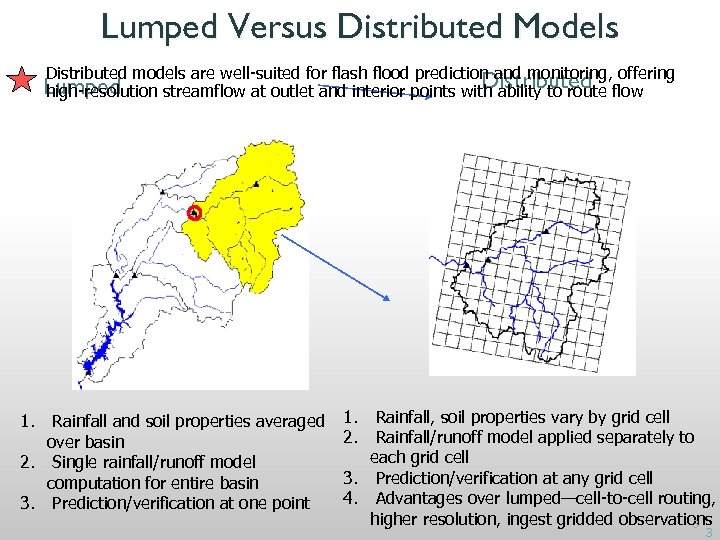
Lumped Versus Distributed Models Distributed models are well-suited for flash flood prediction and monitoring, offering Distributed Lumped high-resolution streamflow at outlet and interior points with ability to route flow 1. Rainfall and soil properties averaged over basin 2. Single rainfall/runoff model computation for entire basin 3. Prediction/verification at one point 1. Rainfall, soil properties vary by grid cell 2. Rainfall/runoff model applied separately to each grid cell 3. Prediction/verification at any grid cell 4. Advantages over lumped—cell-to-cell routing, higher resolution, ingest gridded observations 3 3
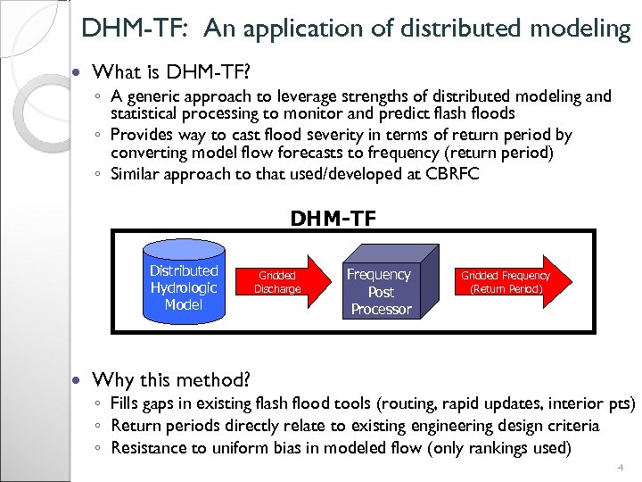
DHM-TF: An application of distributed modeling What is DHM-TF? ◦ A generic approach to leverage strengths of distributed modeling and statistical processing to monitor and predict flash floods ◦ Provides way to cast flood severity in terms of return period by converting model flow forecasts to frequency (return period) ◦ Similar approach to that used/developed at CBRFC DHM-TF Distributed Hydrologic Model Gridded Discharge Frequency Post Processor Gridded Frequency (Return Period) Why this method? ◦ Fills gaps in existing flash flood tools (routing, rapid updates, interior pts) ◦ Return periods directly relate to existing engineering design criteria ◦ Resistance to uniform bias in modeled flow (only rankings used) 4
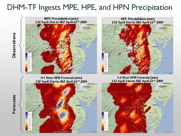
DHM-TF Ingests MPE, HPE, and HPN Precipitation HPE Precipitation (mm) 23 Z April 21 st to 00 Z April 22 nd 2009 0 -1 Hour HPN Forecast (mm) 23 Z April 21 st to 00 Z April 22 nd 2009 1 -2 Hour HPN Forecast (mm) 23 Z April 21 st to 00 Z April 22 nd 2009 Forecasts Observations MPE Precipitation (mm) 23 Z April 21 st to 00 Z April 22 nd 2009 5
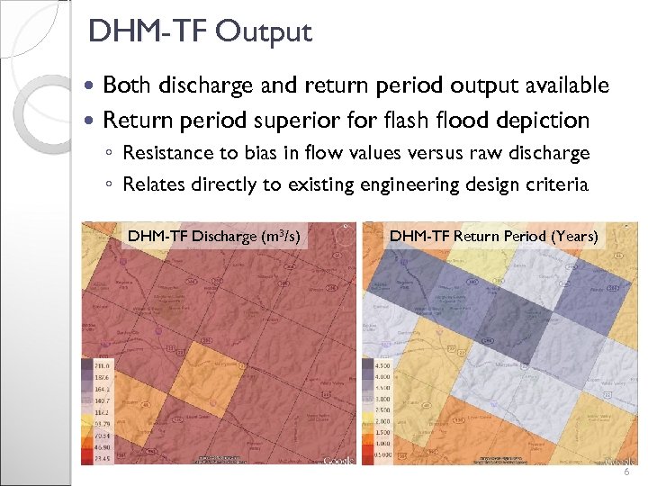
DHM-TF Output Both discharge and return period output available Return period superior flash flood depiction ◦ Resistance to bias in flow values versus raw discharge ◦ Relates directly to existing engineering design criteria DHM-TF Discharge (m 3/s) DHM-TF Return Period (Years) 6
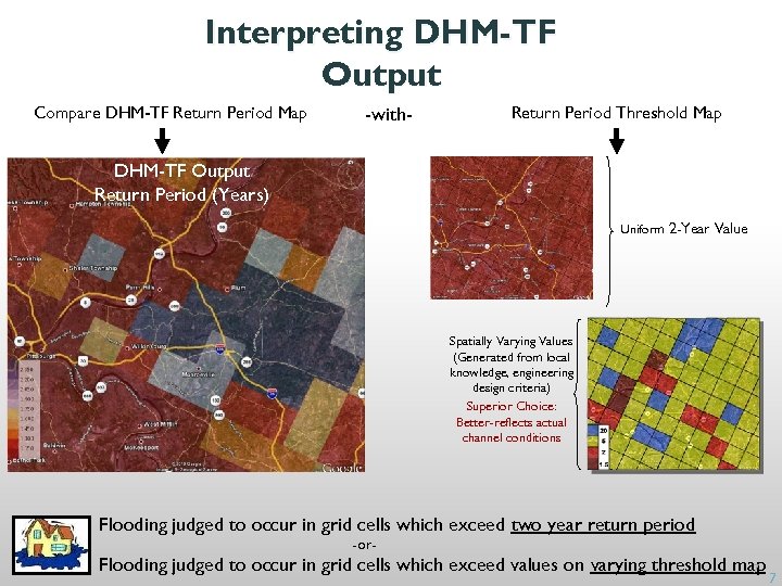
Interpreting DHM-TF Output Compare DHM-TF Return Period Map -with- Return Period Threshold Map Return Period (Years) DHM-TF Output Return Period (Years) Uniform 2 -Year Value Spatially Varying Values (Generated from local knowledge, engineering design criteria) Superior Choice: Better-reflects actual channel conditions Flooding judged to occur in grid cells which exceed two year return period -or- Flooding judged to occur in grid cells which exceed values on varying threshold map 7 7
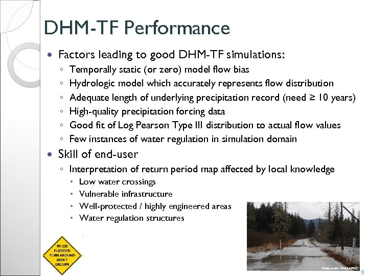
DHM-TF Performance Factors leading to good DHM-TF simulations: ◦ ◦ ◦ Temporally static (or zero) model flow bias Hydrologic model which accurately represents flow distribution Adequate length of underlying precipitation record (need ≥ 10 years) High-quality precipitation forcing data Good fit of Log Pearson Type III distribution to actual flow values Few instances of water regulation in simulation domain Skill of end-user ◦ Interpretation of return period map affected by local knowledge Low water crossings Vulnerable infrastructure Well-protected / highly engineered areas Water regulation structures 8 Photo credit: NOAA APRFC 8
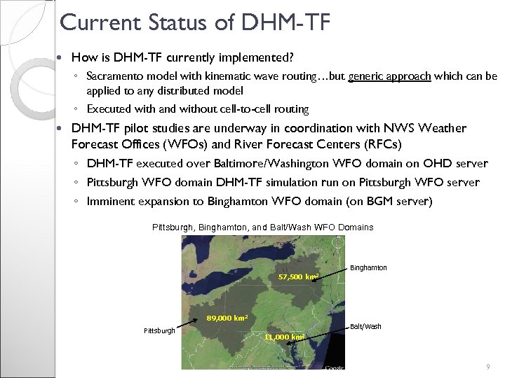
Current Status of DHM-TF How is DHM-TF currently implemented? ◦ Sacramento model with kinematic wave routing…but generic approach which can be applied to any distributed model ◦ Executed with and without cell-to-cell routing DHM-TF pilot studies are underway in coordination with NWS Weather Forecast Offices (WFOs) and River Forecast Centers (RFCs) ◦ DHM-TF executed over Baltimore/Washington WFO domain on OHD server ◦ Pittsburgh WFO domain DHM-TF simulation run on Pittsburgh WFO server ◦ Imminent expansion to Binghamton WFO domain (on BGM server) Pittsburgh, Binghamton, and Balt/Wash WFO Domains Binghamton 57, 500 km 2 89, 000 km 2 Pittsburgh Balt/Wash 11, 000 km 2 9
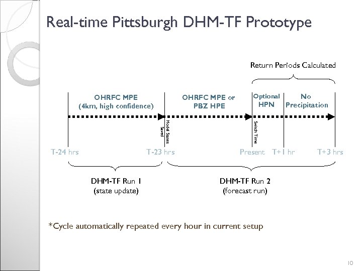
Real-time Pittsburgh DHM-TF Prototype Return Periods Calculated OHRFC MPE (4 km, high confidence) OHRFC MPE or PBZ HPE T-23 hrs DHM-TF Run 1 (state update) HPN No Precipitation Switch Time Model States Saved T-24 hrs Optional Present T+1 hr T+3 hrs DHM-TF Run 2 (forecast run) *Cycle automatically repeated every hour in current setup 10
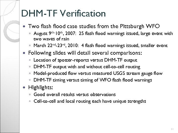
DHM-TF Verification Two flash flood case studies from the Pittsburgh WFO ◦ August 9 th-10 th, 2007: 25 flash flood warnings issued, large event with two waves of rain ◦ March 22 nd-23 rd, 2010: 4 flash flood warnings issued, smaller event Following slides will detail several comparisons: ◦ ◦ Location of spotter-reports versus DHM-TF output with and without cell-to-cell routing Model-produced flow versus measured USGS stream gauge flow DHM-TF timing versus timing of WFO flash flood warnings Highlights: ◦ Good overall results versus observations ◦ Cell-to-cell and local routing each have unique strengths 11
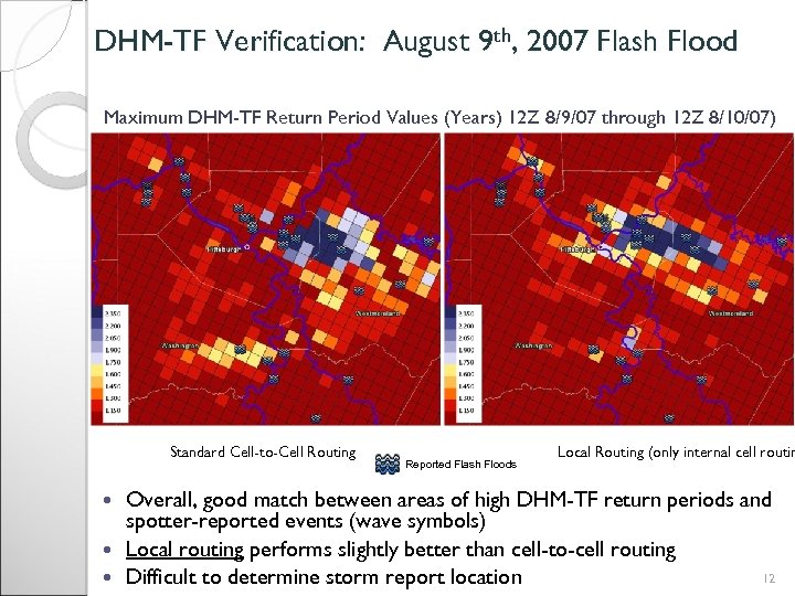
DHM-TF Verification: August 9 th, 2007 Flash Flood Maximum DHM-TF Return Period Values (Years) 12 Z 8/9/07 through 12 Z 8/10/07) Standard Cell-to-Cell Routing Reported Flash Floods Local Routing (only internal cell routin Overall, good match between areas of high DHM-TF return periods and spotter-reported events (wave symbols) Local routing performs slightly better than cell-to-cell routing 12 Difficult to determine storm report location
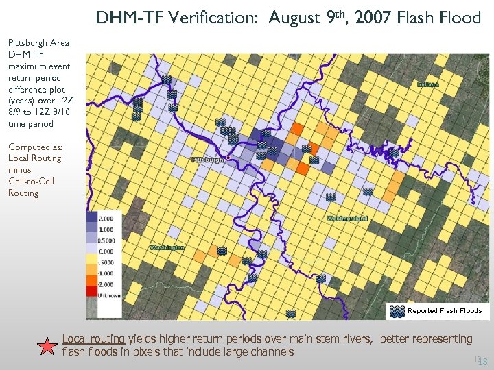
DHM-TF Verification: August 9 th, 2007 Flash Flood Pittsburgh Area DHM-TF maximum event return period difference plot (years) over 12 Z 8/9 to 12 Z 8/10 time period Computed as: Local Routing minus Cell-to-Cell Routing Reported Flash Floods Local routing yields higher return periods over main stem rivers, better representing flash floods in pixels that include large channels 13 13
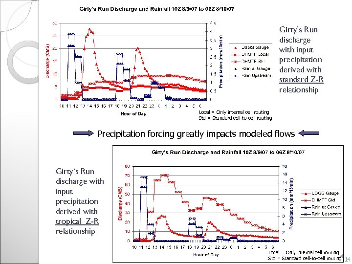
Girty’s Run discharge with input precipitation derived with standard Z-R relationship Local = Only internal cell routing Std = Standard cell-to-cell routing Precipitation forcing greatly impacts modeled flows Girty’s Run discharge with input precipitation derived with tropical Z-R relationship Local = Only internal cell routing 14 Std = Standard cell-to-cell routing 14
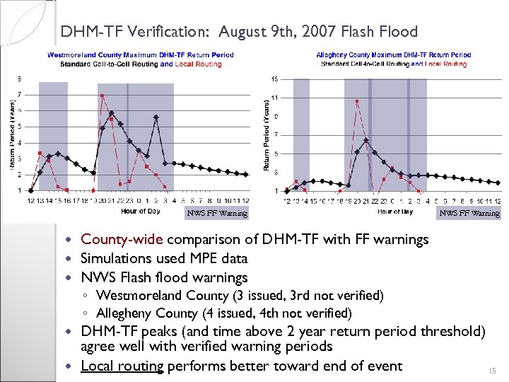
DHM-TF Verification: August 9 th, 2007 Flash Flood NWS FF Warning County-wide comparison of DHM-TF with FF warnings Simulations used MPE data NWS Flash flood warnings ◦ Westmoreland County (3 issued, 3 rd not verified) ◦ Allegheny County (4 issued, 4 th not verified) DHM-TF peaks (and time above 2 year return period threshold) agree well with verified warning periods Local routing performs better toward end of event 15
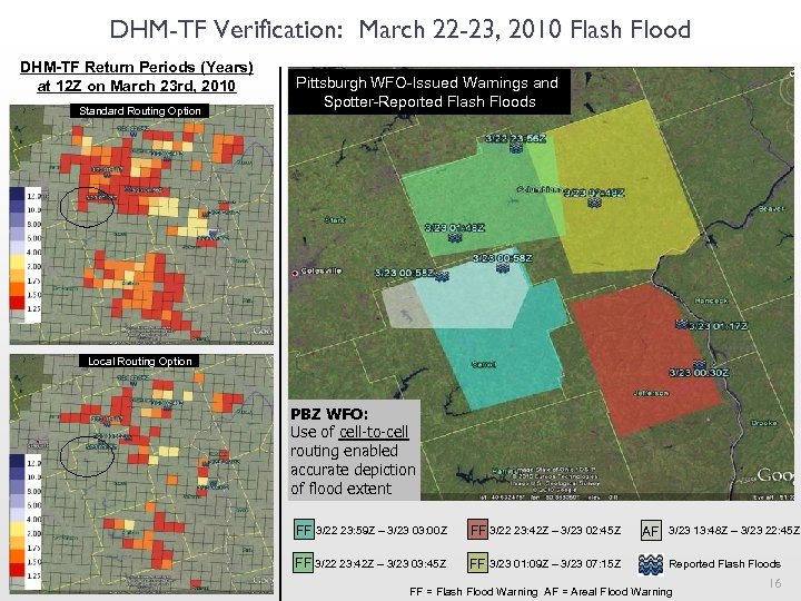
DHM-TF Verification: March 22 -23, 2010 Flash Flood DHM-TF Return Periods (Years) at 12 Z on March 23 rd, 2010 Standard Routing Option Pittsburgh WFO-Issued Warnings and Spotter-Reported Flash Floods Local Routing Option PBZ WFO: Use of cell-to-cell routing enabled accurate depiction of flood extent FF 3/22 23: 59 Z – 3/23 03: 00 Z FF 3/22 23: 42 Z – 3/23 02: 45 Z FF 3/22 23: 42 Z – 3/23 03: 45 Z FF 3/23 01: 09 Z – 3/23 07: 15 Z AF 3/23 13: 48 Z – 3/23 22: 45 Z Reported Flash Floods FF = Flash Flood Warning AF = Areal Flood Warning 16
DHM-TF: Summary and Future Work Summary ◦ DHM-TF: Combines distributed hydrologic model with threshold frequency post-processor return periods ◦ Capitalizes on strengths of distributed modeling ◦ Fills gaps in existing flash flood tools (routing, rapid updates, interior pts) ◦ Collaborative development and promising assessment effort Future Work ◦ ◦ Validation and deployment at additional field locations Operation at higher temporal and spatial resolutions In-depth validation using NSSL SHAVE data Collaborative Assessment…Further refine DHM-TF to better match the needs of forecasters 17

Thank You 18

Extra slides that follow are only for reference if needed 19
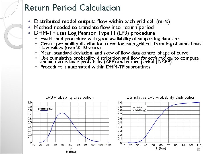
Return Period Calculation Distributed model outputs flow within each grid cell (m 3/s) Method needed to translate flow into return period DHM-TF uses Log Pearson Type III (LP 3) procedure ◦ Established procedure with good availability of supporting data sets ◦ Create probability distribution curve for each grid cell from log of annual max flow values (over ≥ 10 years) ◦ Mean, standard deviation, and skew of flow data control shape of curve ◦ Use cumulative probability distribution and flow for each grid cell to compute annual exceedance probability (AEP) and return period (1/AEP) ◦ Procedure is automated within DHM-TF subroutines LP 3 Probability Distribution Cumulative LP 3 Probability Distribution probability p(y) 20
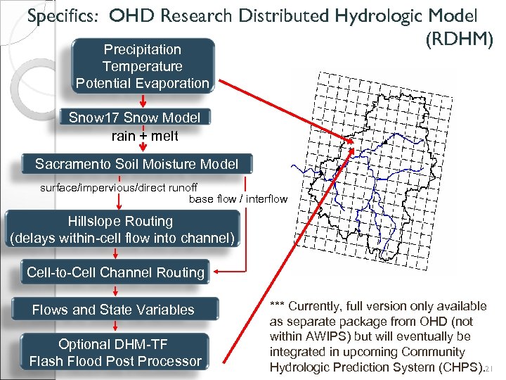
Specifics: OHD Research Distributed Hydrologic Model (RDHM) Precipitation Temperature Potential Evaporation Snow 17 Snow Model rain + melt Sacramento Soil Moisture Model surface/impervious/direct runoff base flow / interflow Hillslope Routing (delays within-cell flow into channel) Cell-to-Cell Channel Routing Flows and State Variables Optional DHM-TF Flash Flood Post Processor *** Currently, full version only available as separate package from OHD (not within AWIPS) but will eventually be integrated in upcoming Community Hydrologic Prediction System (CHPS). 21
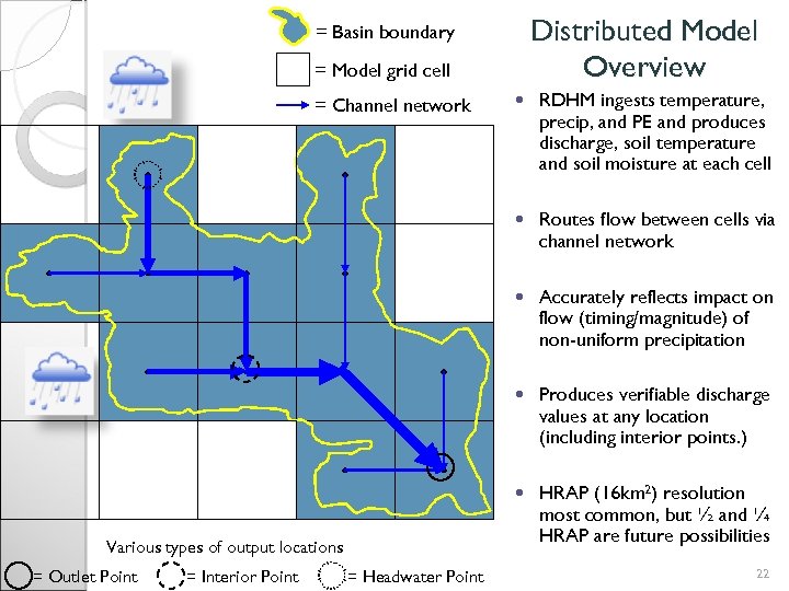
Distributed Model Overview = Basin boundary = Model grid cell = Headwater Point Accurately reflects impact on flow (timing/magnitude) of non-uniform precipitation Produces verifiable discharge values at any location (including interior points. ) = Interior Point Routes flow between cells via channel network = Outlet Point RDHM ingests temperature, precip, and PE and produces discharge, soil temperature and soil moisture at each cell Various types of output locations = Channel network HRAP (16 km 2) resolution most common, but ½ and ¼ HRAP are future possibilities 22
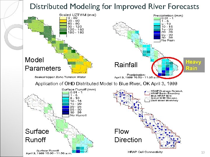
Distributed Modeling for Improved River Forecasts Model Parameters Rainfall Heavy Rain Application of OHD Distributed Model to Blue River, OK April 3, 1999 Surface Runoff Flow Direction 23
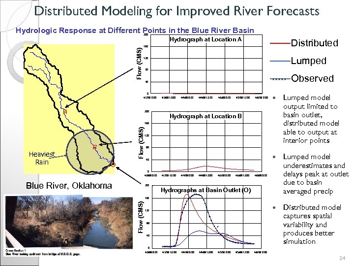
Distributed Modeling for Improved River Forecasts Hydrologic Response at Different Points in the Blue River Basin Flow (CMS) 200 Hydrograph at Location A Distributed 160 Lumped 120 80 Observed 40 0 4/3/99 0: 00 A 200 4/4/99 12: 00 4/5/99 0: 00 4/5/99 12: 00 4/6/99 0: 00 Lumped model output limited to basin outlet, distributed model able to output at interior points Lumped model underestimates and delays peak at outlet due to basin averaged precip 4/4/99 0: 00 4/3/99 12: 00 Distributed model captures spatial variability and produces better simulation Hydrograph at Location B Heaviest Rain Flow (CMS) 160 B 120 80 40 O 0 4/3/99 0: 00 Blue River, Oklahoma 200 4/3/99 12: 00 4/4/99 0: 00 4/4/99 12: 00 4/5/99 0: 00 4/5/99 12: 00 4/6/99 0: 00 Hydrographs at Basin Outlet (O) Flow (CMS) 160 120 80 40 0 4/3/99 0: 00 4/3/99 12: 00 4/4/99 0: 00 4/4/99 12: 00 4/5/99 0: 00 4/5/99 12: 00 4/6/99 0: 00 24
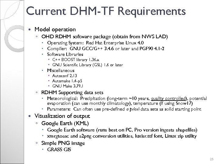
Current DHM-TF Requirements Model operation ◦ OHD RDHM software package (obtain from NWS LAD) Operating System: Red Hat Enterprise Linux 4. 0 Compiler: GNU GCC/G++ 3. 4. 6 or later and PGF 90 4. 1 -2 Software Libraries C++ BOOST library 1. 36. x GNU Scientific Library (GSL) 1. 6 or later Miscellaneous Autoconf 2. 13 Automake 1. 4 -p 5 GNU Make 3. 79. 1 ◦ RDHM Supporting data sets Meteorological: Precipitation (long-term ~10 years, quality controlled), potential evaporation (can use monthly climatology), temperature (if using Snow 17) Parameters: Can often use pre-defined a priori data sets as solid starting point Visualization of output ◦ Google Earth (KML) Google Earth software (runs best on PC, Pro version ingests shapefiles) xmrgtoasc and a 2 png conversion utilities, luxisr. ttf font, Linux zip utility ◦ Simple PNG image GRASS GIS 25
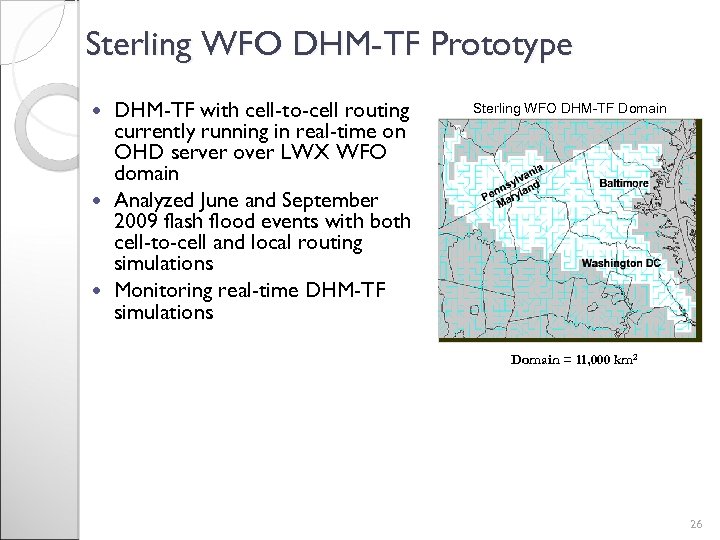
Sterling WFO DHM-TF Prototype DHM-TF with cell-to-cell routing currently running in real-time on OHD server over LWX WFO domain Analyzed June and September 2009 flash flood events with both cell-to-cell and local routing simulations Monitoring real-time DHM-TF simulations Sterling WFO DHM-TF Domain = 11, 000 km 2 26
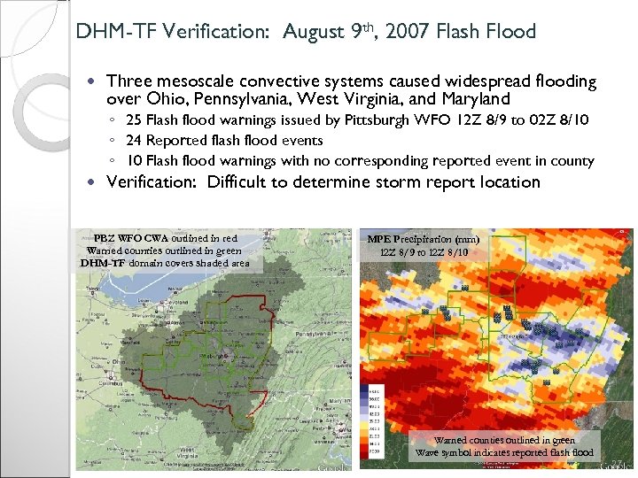
DHM-TF Verification: August 9 th, 2007 Flash Flood Three mesoscale convective systems caused widespread flooding over Ohio, Pennsylvania, West Virginia, and Maryland ◦ 25 Flash flood warnings issued by Pittsburgh WFO 12 Z 8/9 to 02 Z 8/10 ◦ 24 Reported flash flood events ◦ 10 Flash flood warnings with no corresponding reported event in county Verification: Difficult to determine storm report location PBZ WFO CWA outlined in red Warned counties outlined in green DHM-TF domain covers shaded area MPE Precipitation (mm) 12 Z 8/9 to 12 Z 8/10 Warned counties outlined in green Wave symbol indicates reported flash flood 27
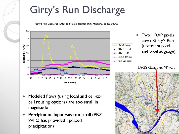
Girty’s Run Discharge Two HRAP pixels cover Girty’s Run (upstream pixel and pixel at gauge) USGS Gauge at Millvale Modeled flows (using local and cell-tocell routing options) are too small in magnitude Precipitation input was too small (PBZ WFO has provided updated precipitation) 28
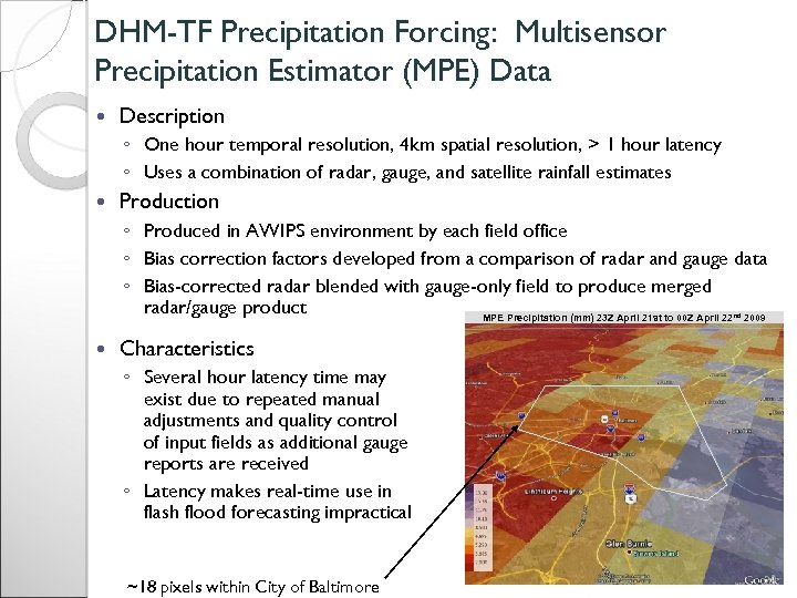
DHM-TF Precipitation Forcing: Multisensor Precipitation Estimator (MPE) Data Description ◦ One hour temporal resolution, 4 km spatial resolution, > 1 hour latency ◦ Uses a combination of radar, gauge, and satellite rainfall estimates Production ◦ Produced in AWIPS environment by each field office ◦ Bias correction factors developed from a comparison of radar and gauge data ◦ Bias-corrected radar blended with gauge-only field to produce merged radar/gauge product MPE Precipitation (mm) 23 Z April 21 st to 00 Z April 22 2009 nd Characteristics ◦ Several hour latency time may exist due to repeated manual adjustments and quality control of input fields as additional gauge reports are received ◦ Latency makes real-time use in flash flood forecasting impractical ~18 pixels within City of Baltimore 29
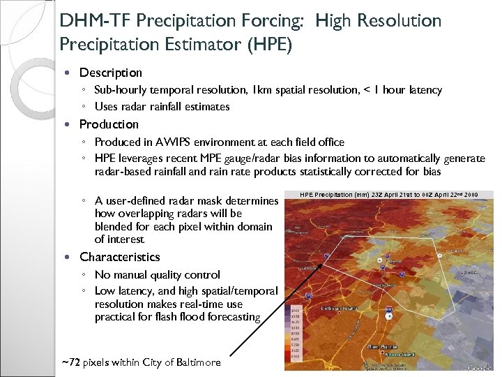
DHM-TF Precipitation Forcing: High Resolution Precipitation Estimator (HPE) Description ◦ Sub-hourly temporal resolution, 1 km spatial resolution, < 1 hour latency ◦ Uses radar rainfall estimates Production ◦ Produced in AWIPS environment at each field office ◦ HPE leverages recent MPE gauge/radar bias information to automatically generate radar-based rainfall and rain rate products statistically corrected for bias ◦ A user-defined radar mask determines how overlapping radars will be blended for each pixel within domain of interest HPE Precipitation (mm) 23 Z April 21 st to 00 Z April 22 nd 2009 Characteristics ◦ No manual quality control ◦ Low latency, and high spatial/temporal resolution makes real-time use practical for flash flood forecasting ~72 pixels within City of Baltimore 30
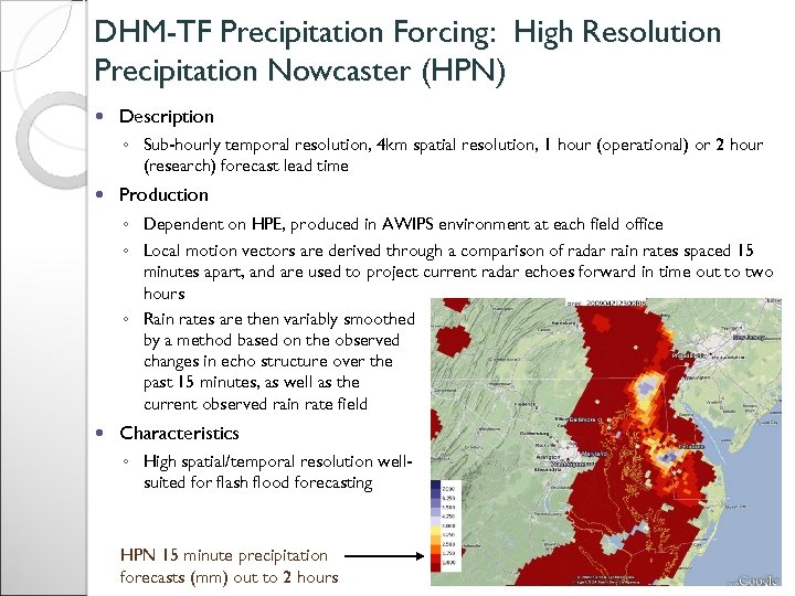
DHM-TF Precipitation Forcing: High Resolution Precipitation Nowcaster (HPN) Description ◦ Sub-hourly temporal resolution, 4 km spatial resolution, 1 hour (operational) or 2 hour (research) forecast lead time Production ◦ Dependent on HPE, produced in AWIPS environment at each field office ◦ Local motion vectors are derived through a comparison of radar rain rates spaced 15 minutes apart, and are used to project current radar echoes forward in time out to two hours ◦ Rain rates are then variably smoothed by a method based on the observed changes in echo structure over the past 15 minutes, as well as the current observed rain rate field Characteristics ◦ High spatial/temporal resolution wellsuited for flash flood forecasting HPN 15 minute precipitation forecasts (mm) out to 2 hours 31
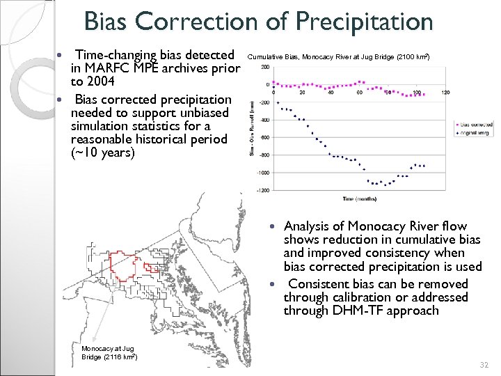
Bias Correction of Precipitation Time-changing bias detected in MARFC MPE archives prior to 2004 Bias corrected precipitation needed to support unbiased simulation statistics for a reasonable historical period (~10 years) Cumulative Bias, Monocacy River at Jug Bridge (2100 km 2) Analysis of Monocacy River flow shows reduction in cumulative bias and improved consistency when bias corrected precipitation is used Consistent bias can be removed through calibration or addressed through DHM-TF approach Monocacy at Jug Bridge (2116 km 2) 32
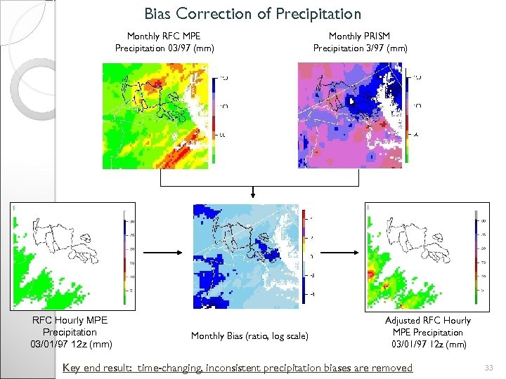
Bias Correction of Precipitation Monthly RFC MPE Precipitation 03/97 (mm) RFC Hourly MPE Precipitation 03/01/97 12 z (mm) Monthly Bias (ratio, log scale) Monthly PRISM Precipitation 3/97 (mm) Adjusted RFC Hourly MPE Precipitation 03/01/97 12 z (mm) Key end result: time-changing, inconsistent precipitation biases are removed 33
e66b244868fb45c3c8f05a7ddeda5b76.ppt