caf655d6165ec7d3d24c93929ff1bf09.ppt
- Количество слайдов: 54


Part II. IRIACC Study VULNERABILITY AND ADAPTATION TO FLOODS & OTHER CLIMATE-RELATED RISKS AMONG MARGINAL COMMUNITIES IN METRO MANILA Emma Porio, Ph. D Professor of Sociology and Chairperson, Department of Sociology and Anthropology, Ateneo de Manila University and Research Fellow, Manila Observatory. Presented in Understanding Vulnerability Session, Adapting to Climate Change and Water Security in Asia, June 18 -20, 2013, Kathmandu, Nepal

Climate impacts: a compound effect combining direct impacts, indirect impacts and pre-existing vulnerabilities. (Source: Jo da Silva, Sam Kernaghan & Andrés Luque, 2012)

Challenges: Vulnerability, Adaptation and Resilience of Asian Cities: MManila • Rapid Urban Growth, Poverty and Inequality in MM • Land subsidence, Intense rainfalls/typhoons, SLR/storm surges, floods, drought/food insecurity • Urban policies/investments (land use, housing, services) and governance frameworks not well coordinated Gov’t: climate proofing of systems still need to integrate CCA and DRRM approaches and increase people’s/communities’ capacity to adapt • Risks and vulnerability uncertainties risk communication & increasing public awareness/adaptation

Approach: Vulnerability, Adaptation and Resilience in Metro Manila • Bio-physical-ecological vulnerabilities* intersect with • Social-Pol-Eco. Vulnerabilities(including governance)*(levels: meso-macro): Rapid urban growth, poverty and inequality interact with • Social-Pol-Eco. Vulnerabilities*(household, family-community levels): socio-economic status (income, occupation, education, gender, health) *Horizontal/vertical interactions (e. g. DALY for health with poverty/gini index by pol-adm unit)

Understanding Vulnerability, Adaptation Resilience in Metro Manila • Analytical Approaches: assessing and characterizing vulnerability (flood): • Overall flood vulnerability (Bio-physical. Social): Systems Dynamics Analysis/Simulator Model • Interactions/Intersections of Sectors: Multiple Drivers/Scales Multivariate analysis (e. g. , sampling frames informed by the bio-physical and governance drivers factorial ecological analysis/principal component analysis for social variables)
 • Primary")
Analytical Frameworks/ Methodologies • Data Sources: Primary and Secondary (Q & Q) • Primary Data Collection Methods: Household Surveys (Vulnerable Population; Commercial. Industrial), Focus group discussions (FGDs) and Key Informant Interviews (Officials, leaders of industry, community, civil society) • Sampling frame: coastal/lake/headwaters alluvial • Analytical Frames: 1) Dynamic Simulator Modeling, climate modeling 2) multivariate analysis (e. g. factorial ecology analysis/principal component analysis, economic modeling, health/DALY)

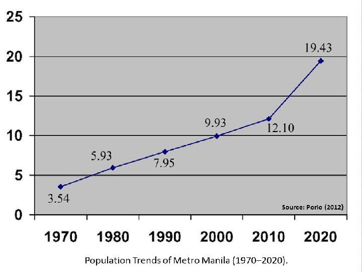
Metro Manila: Governance, DRRM and Climate Change Adaptation Sources of Risk/Exposure: • Population: 12 M; daytime: 1618 M people • Poverty Incidence: 20 -30 percent • Percentage of population living in informal settlements/no security of tenure: 40 -50 percent • National capital—below sea level • Located in 3 flood basins • Density: 18, 000 per sq. km (M 40 k). • Urban-Economic Primacy— pop. 12 x the next largest city; accounts 37 % of national GDP • Earthquake fault runs through the metropolis (cf. Loyzaga’s slides) • Governance (decentralized and democratized): MMDA (16 cities) and local government units (17 political wills—cf. Alcazaren 2013)

Metro Manila: Bay, Flood Basins, Rivers, Lake

Research Sites: 15 Urban Poor Communities in Three Flood Basins

Governance: DRRM and Climate Change Adaptation • Governance: No political will → not true → there is strong political in 17 cities & municipalities the 17 political wills drive Metro Manila governance (cf. Alcazaren (2013) • Illustrative Case: MMDA/Nat. Gov’t: Flood Control Program Failed for Local Governments: Installed “Bombastik” or Flood Pumps (later slide)
 in the CAMANAVA Area")
Map Showing Tidal Gates and Pump Stations (Bombastik) in the CAMANAVA Area

PHILIPPINES: 1950 -2050 Source: UN World Urbanization Prospects: The 2007 Revision
")
Famous Architect’s Metro Manila: 1912 -2012. Paulo Alcazaren (2012)

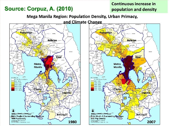
Major Urban Centers in the Philippines. . . Source: Corpus, 2007.

Vulnerability, Adaptation, Resilience and the Urban Divide in Metro Manila • Economic Divide • Spatial Divide • Opportunity Divide • Social Divide

Urban Growth, Poverty and Social Inequality in the Philippine Cities. .

. Urbanization, Governance & Household Vulnerability • The informal city: 500, 000 informal settler families or 3. 5 million (105, 000 -HUDCC); 60 percent no security of tenure, inadequate access to basic services) • Solid Waste: 8, 500 tons daily (1/4 of the 35, 000 produced by the country; 41, 014 persons per sq. kilometer in Manila (Alcazaren (2012) • Transport/Traffic congestion: Vehicles: 2 million (about one-third of nation’s 6 M vehicles registered) • Investments (commercial, real estate, infrastructure) to develop/protect the city increases vulnerability

Garbage Filling the Tributary of Pasig River
")
Source: Manda, E. (2009)

Threats to Urban/City Resilience: Poverty, Inequality and Social Exclusion Business establishments Informal settlements
: ‘High Rise’ Buildings vs. slum and/or informal settlements")
Makati City (Financial Capital, Philippines): ‘High Rise’ Buildings vs. slum and/or informal settlements

The Most Vulnerable Populations in Metro Manila • Live in low-lying or swampy/wetlands, informal settlements • Low-income and/or no stable sources of income (less than US$ 1/day); high number of dependents • Majority (about 80 percent) have no security of tenure • About 75 percent have no adequate access to basic services (potable water, electricity, sanitation facilities get flooded, etc. ) • About 75 percent regularly suffer income/job loss, sickness, and schooling of children as a result of floods/typhoons • About 75 percent suffer loss of HH appliances, garments or need house repair due to typhoons/floods • Single-headed/female-headed households (singles, widows, widowers and old)

Table 2. Ecological-Envi Vulnerabilities of Places: Social Vulnerabilities for Urban Poor Households in the Three Metro Manila Flood Plains Pasig. Marikina KAMANAVA West Mangahan Environmental characteristics: Sources of vulnerabilities Living in flood-prone areas along riverlines/riverbanks, subsidence, clogged waterways Living along flood-prone riverlines; near the coast (prone to floods and sea level rise/tidal surges), land subsidence, clogged waterways Living along flood prone riverlines (Mangahan Floodway, Napindan Channel) near Laguna Lake, swampy lands/wetlands, subsidence, clogged waterways Socio-eco. characteristics: Sources of vulnerabilities Mdn monthly income: P 18, 000; Ave. Education--9. 5 yrs. Mdn monthly income: P 15, 000 Ave. education: 11 years Mdn monthly income: P 8, 000; Educ: 7. 5 years; Housing dilapidated, light materials, migrants, renters, women-headed households, no services
 Pre-Ondoy Period")
Household Losses by Gender Due to Floods from Tropical Storm Ondoy (Before-During-After) Pre-Ondoy Period Post-Ondoy Period Women- Menheaded HH HH Men- Women Men headed -headed HH HH hea ded HH 33% 21% 40% 11% 33% 90% - 33% 10% No. of school absences Work days lost from sickness No. of work days lost Ave. income loss Ave. expenses on medicines Ave. losses Source: Porio (2011) (appliances, etc. ) - - 11% 6% - - - 50% 24% -10% - 17% 60% -20% Womenheaded HH -
 Architecture—design/materials 2) Raising/adding floors 3) Movable Storage")
Adaptive Responses Water-Based/Adaptive Lifestyle: Household level 1) Architecture—design/materials 2) Raising/adding floors 3) Movable Storage of appliances/garments City/Local Government Level: 1) DRRM-CCA policies 2) Organizational/Institutional 3) Early warning system 4) Flood control programs 5) Evacuation and Relocation

Poverty, Environment, and Climaterelated Risks in Metro Manila

Day After Typhoon Milenyo: Children Looking at playgound in Navotas
")
Lakeside Community: Habagat Floods (2012)

SWAT and Pasig City Rescue Officials in the Immediate Rescue and Evacuation Plan for Flood Victims (2009)

Plastic Gallons as Floating Gear during Habagat Floods

Rescue Work during Habagat Floods in Marikina City

Children: No Fear of “Lepto”

Pedi-cab: Only Reliable Transport

Life Continues…Still Need to Move Even if the City Has Stopped
")
Transportation During Habagat Floods (August 2012)

Street Homeless Group: Waiting for the Floods to Subside in Quezon City

Relaxing While Waiting to Rescue in Marikina
")
Relief Distribution during Habagat Floods (August 2012)

Bangkulasi, Navotas City: After Typhoon Milenyo

Coastal Cities at Risk Research: Understanding Vulnerability and Increasing Adaptive Capacity and Resilience • Calibrated interconnectedness of bio-physical and social (poverty-inequality/ health politicaleconomic issues of power and resource distribution underlying vulnerability and adaptation) • Social–spatial dimensions: planning/programming • Science-based/empirically driven to social, political, economic applications to reduce risks to the city’s most vulnerable: urban poor population • Connecting/integrating these at different levels of decision-making/action frameworks

Maraming salamat po! Salamat kaayo sa inyong tanan! Thank you!

Acknowledgements • Dir. Antonia Loyzaga • Dr. Gemma Narisma • Dr. Celine Vicente • Dr. Kendra Gotangco • Dr Fernando Siringan • Dr. Posa Perez • FORIN Team • Jessica Bercilla • Julie Dado • Emil Gozo, Justin See, John Paul Dalupang, Liz del Castillo, Jo. Ed Perez • Raul Dayawon, Patricia Sanchez

Asia’s Urbanization: Physical, Social, Pol-Eco. Dimensions From 10% to 50% Population of Urban Areas in Asia in a duration of 61 years 43% Urban Share of Asia’s Population in 2010 63% Projected Urban Share of Asia’s Population in 2016 21 out of 27 Projected Number of Asia’s Megacities by 2025 34% Total World Merchandise Exports from Asia Pacific Region in 2011 (from 25% in 2001) 42. 2% Average Share of Remittances of Tajikistan 23. 3% Average Share of Remittances of Tonga 23. 2% Average Share of Remittances of Kyrgyz Republic 410 million Projected Urban Asians at Risk of Coastal Flooding by 2025 67% Asian Cities Failing to Meet European Union’s Air Quality Standard 97% Growth of Average per Capita Greenhouse Gas Emissions in Asia 506 million Slum Dwellers in Asia in 2010 408 million Asians Without Access to Improved Sanitation Facilities

. . Child crossing makeshift bridge to buy food across waterway in swampy Ibayo Tipas, Taguig City, West Mangahan Flood Basin

1. How does the city work? URBAN SYSTEMS URBAN POVERTY REDUCTION VULNERABLE GROUPS DISASTER RISK REDUCTION PERI-URBAN SYSTEMS URBAN CLIMATE CHANGE RISK 2. What are the direct and indirect impacts of climate change? CLIMATE CHANGE Direct Impact RURAL SYSTEMS 3. Who is least able to respond to shocks and stresses? Climate impacts: a compound effect combining direct impacts, indirect impacts and pre-existing vulnerabilities. (Porio, 2013 modified from Jo da Silva, Sam Kernaghan & Andrés Luque, 2012)

Source: Population Division of the Department of Economic and Social Affairs of the United Nations Secretariat, World Population Prospects: The 2006 Revision and World Urbanization Prospects: The 2007 Revision, http: //esa. un. org/unup.

Urbanization in the ASEAN Countries. . . Source: UN 2007.

Poverty in Metro Manila Number of Informal Settlers in Metro Manila by City and Municipality, 2002
")
Source: Porio (2011)
")
Source: Porio (2011)
 in 2011 in the Philippines (plus earthquakes)")
Deadly Storms/Typhoons (Out of the 19) in 2011 in the Philippines (plus earthquakes)
caf655d6165ec7d3d24c93929ff1bf09.ppt