

dbf668e2ea1d6769bc3a53351fa3caf9.ppt
- Количество слайдов: 64
 OVERVIEW OF MAPPING WORKS Directorate of Census Operations Madhya Pradesh Bhopal
 Census Organization is well known as one of the largest producer of Thematic maps in the country. 1. Cartography has been an integral part of Census since 1872. i. Maps were prepared by Traditional Cartography till 1991. ii. Digital Cartography (GIS Based) has been applied in Census Mapping since 2001 Census. 2. A large variety of Thematic & Administrative Maps such as State, District, Sub-District, Village, Town and Wards in Towns are prepared by the organization. 3. Census Mapping is done in two phases : Pre Census Mapping & Post Census Mapping.
 DCO Madhya Pradesh, Bhopal Supervision & preparation of") Functions of GIS Lab (Map Section) DCO Madhya Pradesh, Bhopal Supervision & preparation of Maps at State Level Preparation of Different Projects as per Guidelines issued from ORGI Digital Updating of base maps incorporating all jurisdictional changes occurred after 2001 Census as per guidelines issued from Map Division (ORGI, New Delhi). Physical Verification & Certification of Maps from respective authorities. Preparation of GIS based Administrative and Thematic maps showing Census & Non-Census Data for different Census Publications. The GIS Lab is well equipped with Arc GIS softwares headed by RO Map and team of Geographer and 5 Senior Drawing Staff.
Functions of GIS Lab (Map Section) DCO Madhya Pradesh, Bhopal Supervision & preparation of Maps at State Level Preparation of Different Projects as per Guidelines issued from ORGI Digital Updating of base maps incorporating all jurisdictional changes occurred after 2001 Census as per guidelines issued from Map Division (ORGI, New Delhi). Physical Verification & Certification of Maps from respective authorities. Preparation of GIS based Administrative and Thematic maps showing Census & Non-Census Data for different Census Publications. The GIS Lab is well equipped with Arc GIS softwares headed by RO Map and team of Geographer and 5 Senior Drawing Staff.
 GIS LAB OF MAP SECTION
 Work flow of Mapping Works Based on GIS Environment Maps acquired from Different Sources Scanning Digital Processing Real World Pu Ce bl nsu ica s tio ns Output of Maps Mapping in GIS Environments
 Phases of Census Mapping Pre Census Mapping Post Census Mapping
 Pre Census Mapping Coverage Upadation of Tahsils level map showing village level boundaries, Town limits and out growths, CD Block boundaries road and rail network along with drainage, these Tahsil maps have been treated as Charge maps. State (Madhya Pradesh) Updating state map showing jurisdictional changes at the district and tahsil level occurred during 2001 -11. Updating District level map showing boundaries of Tahsils, CDBlocks, their hqrs, locations of Towns, transport network & drainage. Districts (50) Tahsils (342) Statuary Towns (364) Census Towns (112) Towns (476) Ward Level Mapping Villages (54903) Town boundary along with wards, major benchmarks and road and rail networks with drainage Ward Maps of Bhopal tow showing House Number an other details. EB Mapping EB maps prepared at household level
 Updated State Map
 Updated District Level Map
 Updated Tahsil Level Map
 GIS Town Mapping Project: Bhopal Nagar Nigam: Office of the Registrar General India had undertaken a GIS Mapping project for capital towns to create separate digital ward & their EB maps showing their House Numbers , transport network, and important landmarks with the objective to use the same in the population enumeration work of 2011 Census.
 Town Level Map
 Ward Level Map
 EB Level Map
 1. Provisional Population Totals Paper I &II") Post Census Mapping Publications State (Madhya Pradesh) 1. Provisional Population Totals Paper I &II 2. Administrative Atlas 3. Census Atlas 1. Administrative Atlas 2. DCHB District (50) Census Town (112) Tahsils (342) Towns (476) Statuary Town (364) 1. Administrative Atlas 2. DCHB 1. Town Directory 2. GIS Based Town Mapping Ward Level Mapping Villages (54903) EB Mapping
Post Census Mapping Publications State (Madhya Pradesh) 1. Provisional Population Totals Paper I &II 2. Administrative Atlas 3. Census Atlas 1. Administrative Atlas 2. DCHB District (50) Census Town (112) Tahsils (342) Towns (476) Statuary Town (364) 1. Administrative Atlas 2. DCHB 1. Town Directory 2. GIS Based Town Mapping Ward Level Mapping Villages (54903) EB Mapping
 Selected Thematic/Time Series Maps of Census Publications 2011
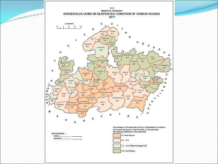
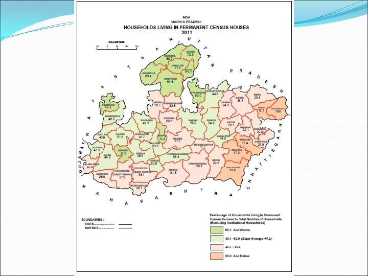
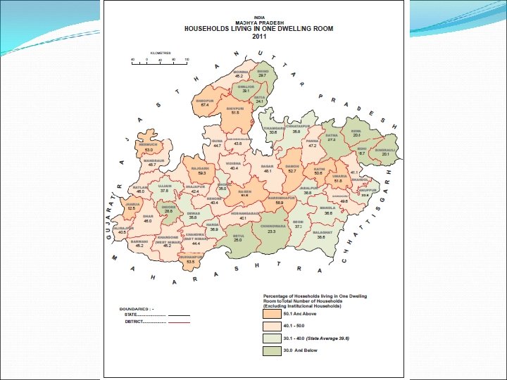
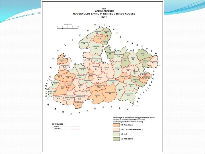
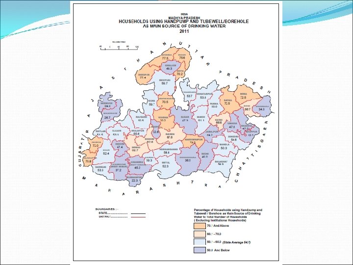
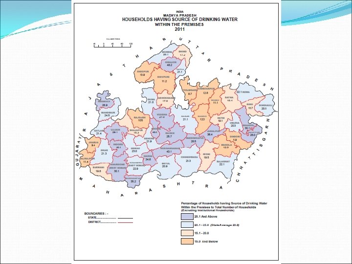
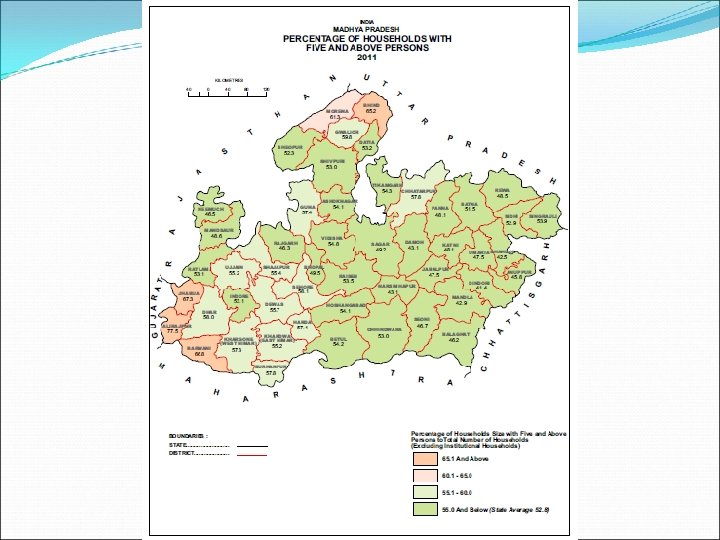
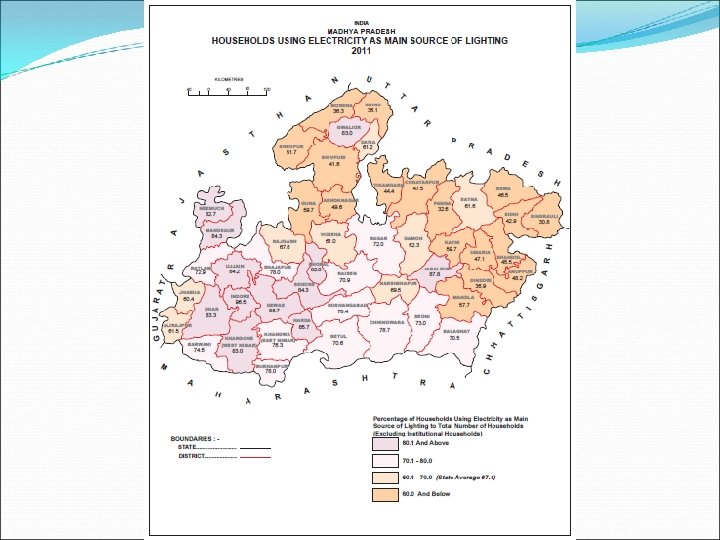
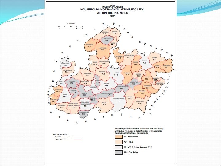
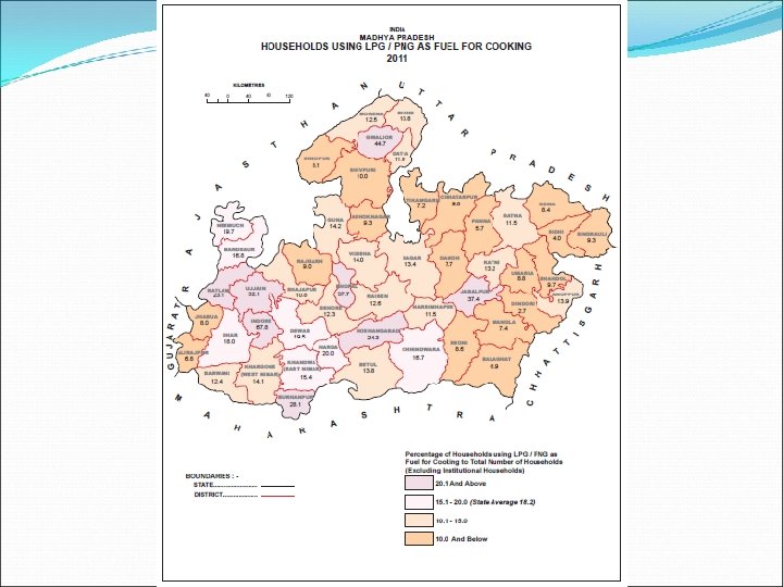
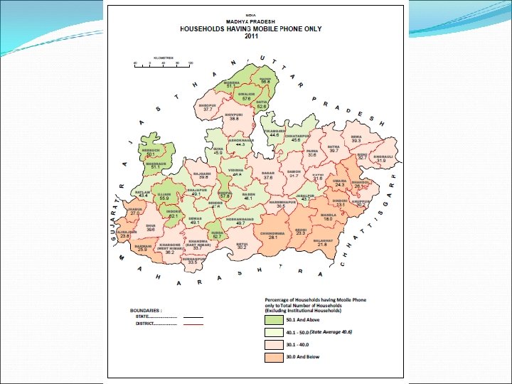
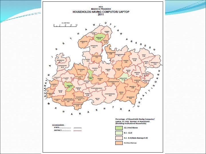
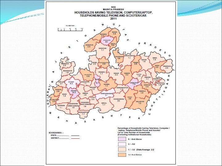
 SELECTED MAPS OF HOUSING ATLAS OF MADHYA PRADESH – 2011 BASED ON HOUSES, HOUSEHOLD AMENITIES AND ASSETS
 Selected Maps of Administrative Atlas of Madhya Pradesh 2011
 SALIENT FEATURES Ø Administrative Atlas of Madhya Pradesh 2011 has been prepared and published. Ø It shows the latest administrative maps of the state. Ø The volume has three parts. Part I contains Position of State in India followed by administrative divisions (Divisions, Districts and Tahsils) on state map 2011 and Jurisdictional changes occurred at district and tahsil level during 2001 -11. Ø Part II consists of evolution of administrative divisions of the state from the year 1951 to 2001. Ø Part III shows all 50 district and 342 tahsil maps of 2011 showing all villages and other details such as transport network and physical features.
 PART - I
 PART - I
 PART - I
 PART - II
 PART - II
 PART - II
 PART - II
 PART - II
 PART - II
 PART - III District Map
 Tahsil Map
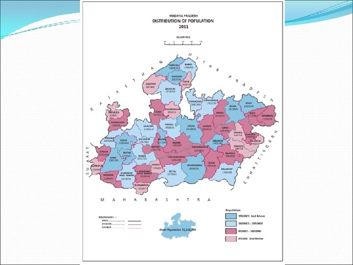
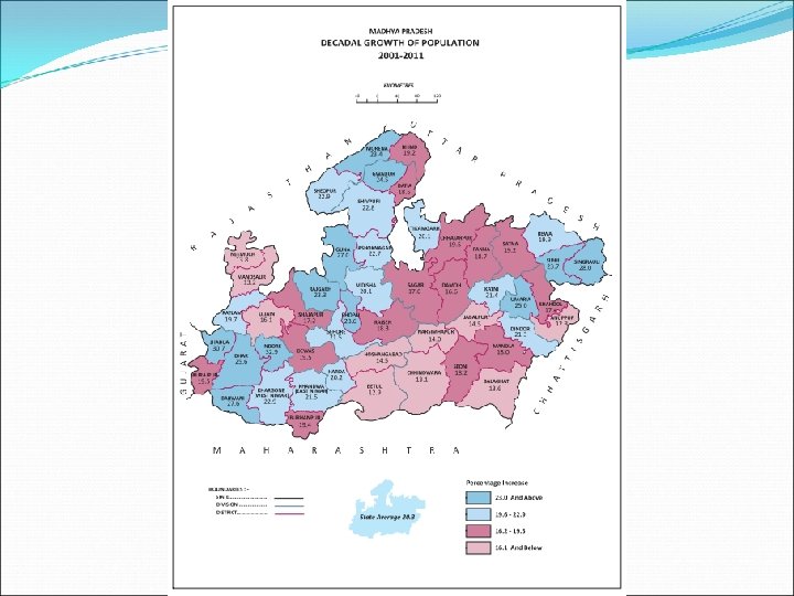
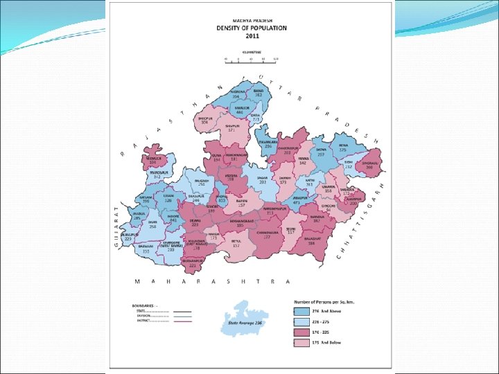
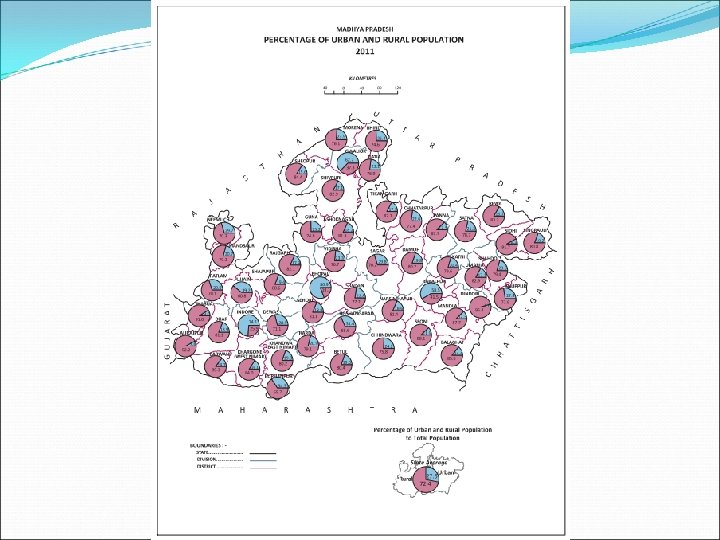
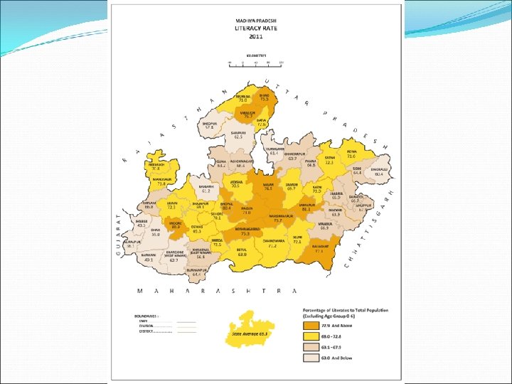
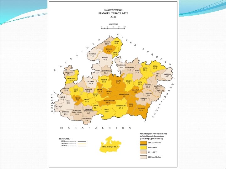
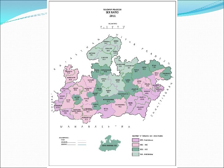
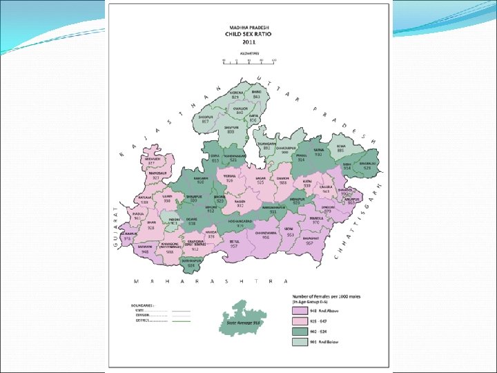
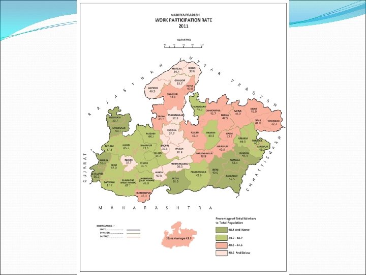
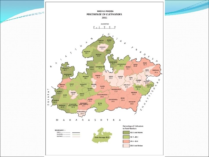
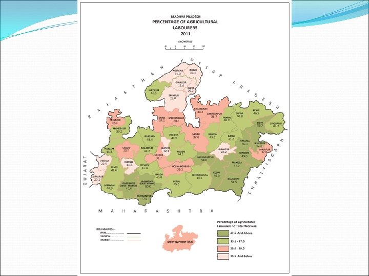
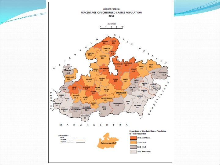
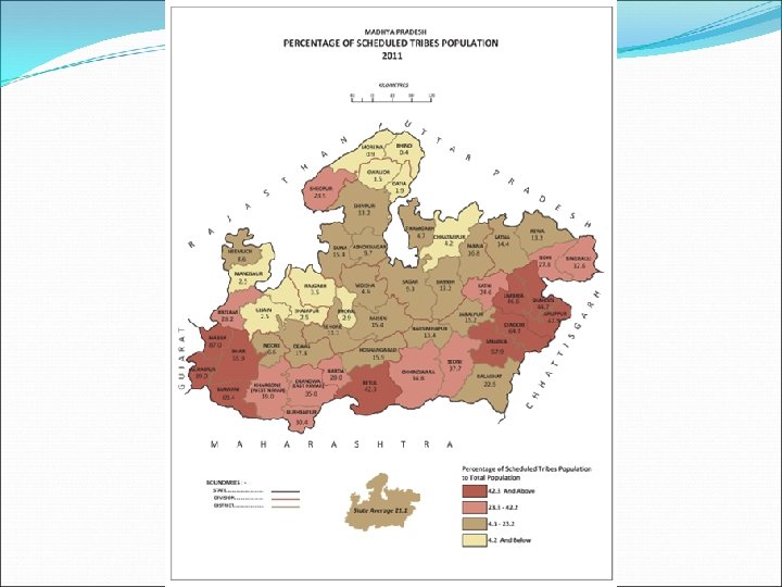
 SELECTED THEMATIC MAPS OF PRIMARY CENSUS ABSTRACT MADHYA PRADESH - 2011
 SELECTED MAPS OF DISTRICT CENSUS HANDBOOK PUBLICATION - 2011
 DISTRICT MAP
 TAHSIL MAP
 TAHSIL MAP
 TAHSIL MAP
 TAHSIL MAP
 Thanks