

700b2cc8cff6c0fd5237e386cd231382.ppt
- Количество слайдов: 40
 Overview of GIS Modeling Shih-Lung Shaw and Dali Wang Department of Geography & Department of Computer Science University of Tennessee Knoxville, TN 37996 sshaw@utk. edu and dwang@cs. utk. edu “Computational Science for Natural Resource Managers” Workshop University of Tennessee, Knoxville April 19 -22, 2006
 Presentation Outline: Different approaches of coupling GIS with models Strengths and weaknesses of GIS for analysis/modeling Characteristics of GIS-centric approach, Linked GISModeling approach, and Modeling-centric approach Arc. GIS software architecture Integration of GIS with dynamic modeling
 Different approaches of coupling GIS with models
 Three Types of Coupling Approaches: Coupling GIS with a stand-alone modeling package by exchanging files: GIS is used mainly for pre-processing (data preparation) and post-processing (display/visualization). Requires an exchange format that is understood by both the GIS and the modeling packages (e. g. , Arc. View shapefile format). This is the easiest approach. (Source: Goodchild, 2005)
 Integrating GIS with modeling package using standards such as Microsoft’s COM and. NET that allow a single script to invoke commands from both packages: This is now a common approach (e. g. , Arc. Objects with COM-compliant programming languages). (Source: Goodchild, 2005)
 The entire model is executed by calling functions of the GIS using a single script. In other words, the model is embedded in the GIS (e. g. , Model Builder in Arc. GIS). (Source: Goodchild, 2005)
 suggests three similar approaches: Loose coupling employs") Linking GIS and Modeling Systems: Maguire (2005) suggests three similar approaches: Loose coupling employs common file structures, file translators, and more recently, Web services messaging. Moderate integration uses techniques such as remote procedure calls and shared database access. Tight integration can be achieved by, for example, objectcomponent calls, or function calls. (Source: Maguire, 2005)
Linking GIS and Modeling Systems: Maguire (2005) suggests three similar approaches: Loose coupling employs common file structures, file translators, and more recently, Web services messaging. Moderate integration uses techniques such as remote procedure calls and shared database access. Tight integration can be achieved by, for example, objectcomponent calls, or function calls. (Source: Maguire, 2005)
 Loose Moderate Tight Time to integrate Fast Medium Slow Programmer expertise Low High Medium Execution speed Slow Medium Fast Simultaneous execution capability Low High Debugging Easy Moderate Hard (Source: Westervelt, 2002; Maguire, 2005)
 GIS for Spatial Analysis and Modeling: Current leading commercial GIS software offers decent analysis and modeling capabilities in areas such as: Vector overlay Raster analysis Cartographic modeling Geostatistical estimation Network analysis Visualization of 2 D and 2. 5 D data (Source: Maguire, 2005; Lo & Yeung, 2002)
 Current commercial GIS software need further development in areas such as: Exploratory spatial data analysis (EDSA) Dynamic system simulation Operations research optimization Spatial statistics Visualization of multidimensional data (Source: Maguire, 2005)
 Software Architecture Characteristics GIS-centric Systems - Extend GIS software system - GIS look and feel - Single UI, data model, data management, etc. - Geographic focus is explicit Linked GIS- - Loose- and close-coupled options Modeling - Two UIs, data models, data management, etc. Systems - Custom file translation or software linkage Modelingcentric Systems - Extend modeling systems - Modeling system look and feel - Single UI, data model, data management, etc. - Limited tools for visualization, data transformation, etc. Examples - Nature. Serve Vista (Ecosystem management) - CATS (Emergency response) - MIKE BASIN (Hydrological basins) - SLEUTH (Land-use estimation) - RAMAS GIS (Ecological population simulation) - TRANUS-Arc. GIS (Transport planning) - SWARM (Wildfire management) - Re. Past (Infectious diseases, civil violence, etc. ) (Source: Maguire, 2005)
 Model Sharing: There have been many efforts of promoting data sharing (e. g. , data repositories, digital libraries, data warehouses). But, limited efforts are put into the creation of equivalent infrastructure for sharing methods and models. “Model and method sharing, or more generally the sharing of process objects, is a core concept of the emerging Grid, the high-performance worldwide network of research computers, …. . In the next few years, dramatic improvements are expected in the availability of techniques for sharing methods and models. ” (Goodchild, 2005, p. 15) (Source: Goodchild, 2005)
 Arc. GIS software architecture
 Four key parts of GIS software: Information Model: defines the classes of objects that can be represented from the domain of interest and how they behave and interact (e. g. , vector, raster, TIN, image, etc. ) Data Manager: commonly implemented as a database management system (DBMS). Process Functions (Tools): e. g. , data input, management, query, analysis, visualization functions. Interfaces: include user interfaces (UI) and application programming interfaces (API) (Source: Maguire, 2005)
 Arc. GIS 9 Overview: Arc. GIS 9 is a family of GIS software products. Arc. GIS Desktop: an integrated suite of GIS functions. Arc. GIS Engine: embeddable GIS component libraries for building custom applications using multiple application programming interfaces. Arc. GIS Server: a platform for building server-side GIS applications in enterprise and Web computing frameworks. (Source: ESRI, 2004)
: GIS Web server to publish maps, data, and metadata") Arc. IMS (Internet Map Server): GIS Web server to publish maps, data, and metadata through open Internet protocols. Arc. SDE (Spatial Data Engine): an interface for managing geodatabases in different relational database management systems (RDBMS). and other products (Arc. Reader, Arc. Pad, etc. ).
Arc. IMS (Internet Map Server): GIS Web server to publish maps, data, and metadata through open Internet protocols. Arc. SDE (Spatial Data Engine): an interface for managing geodatabases in different relational database management systems (RDBMS). and other products (Arc. Reader, Arc. Pad, etc. ).
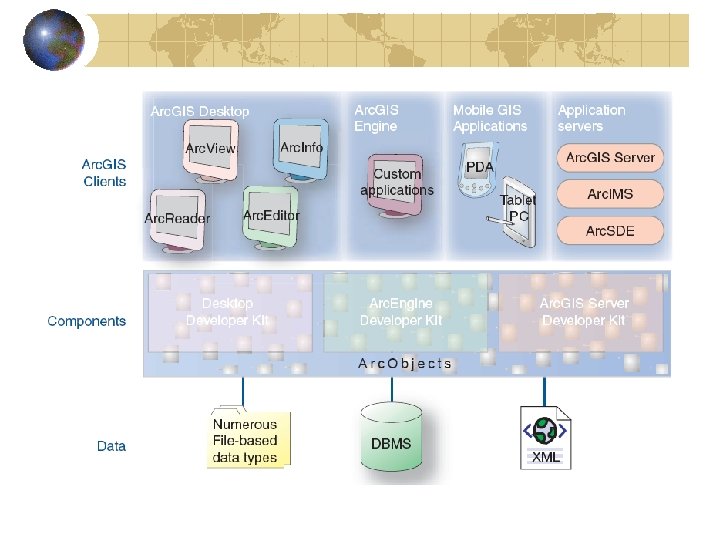
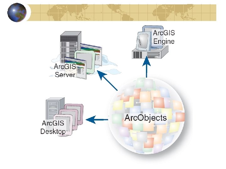
 What is Arc. Objects? Arc. GIS system is built and extended using software components called Arc. Objects, which includes a large number of programmable components. Users can work with Arc. Objects using standard programming frameworks to extend Arc. GIS Desktop, build custom applications with Arc. GIS Engine, and implement enterprise GIS applications using Arc. GIS Server.
 Arc. Objects is a set of platform-independent software components, written in C++, that provides services to support GIS applications on the desktop, in the form of thick and thin clients, and on the server. Arc. Objects makes use of the Microsoft Component Object Model (COM). For operating systems other than Microsoft Windows, this infrastructure must be provided for the Arc. Objects system to function.
: Arc. GIS Desktop software developer kit (SDK) supports the COM") Software Development Kit (SDK): Arc. GIS Desktop software developer kit (SDK) supports the COM and. NET programming frameworks. Developers can apply the Arc. GIS Desktop SDK to add extended functions, new GIS tools, custom user interfaces, and full extensions for improving professional GIS productivity of the Arc. GIS Desktop applications. Arc. GIS Server developer kit enables developers to build central GIS servers to host GIS functions that are accessed by many users, perform back office processing on large central GIS databases, build and deliver GIS Web applications, and perform distributed GIS computing.
Software Development Kit (SDK): Arc. GIS Desktop software developer kit (SDK) supports the COM and. NET programming frameworks. Developers can apply the Arc. GIS Desktop SDK to add extended functions, new GIS tools, custom user interfaces, and full extensions for improving professional GIS productivity of the Arc. GIS Desktop applications. Arc. GIS Server developer kit enables developers to build central GIS servers to host GIS functions that are accessed by many users, perform back office processing on large central GIS databases, build and deliver GIS Web applications, and perform distributed GIS computing.
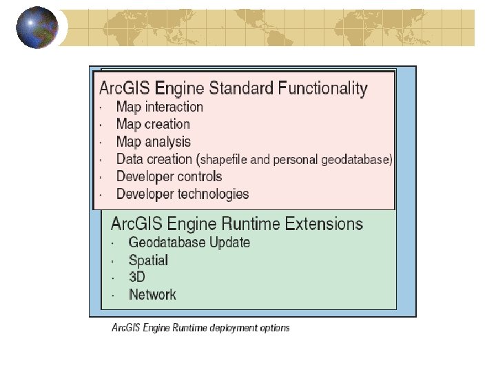
 Arc. GIS Engine is a simple, application-neutral programming environment for Arc. Objects. Its SDK provides a series of embeddable Arc. GIS components that are used outside the Arc. GIS Desktop application framework. Using the Arc. GIS Engine Developer Kit, developers can build focused GIS solutions with simple interfaces to access GIS functions or embed GIS logic in existing user applications to deploy GIS to broad groups of users. Arc. GIS Engine is supported on Windows, Solaris, and Linux (Intel), developers can create cross-platform custom solutions.
 Who can benefit from Arc. GIS Engine? Users who want domain-specific, easy-to-use applications that can incorporate the power of GIS into a user-friendly environment. The underlying components of Arc. GIS Desktop are the same Arc. Objects components that make up Arc. GIS Engine. This allows every Arc. GIS Desktop user the ability to run Arc. GIS Engine applications. You can develop applications based on Arc. GIS Engine and deploy them to Arc. GIS Desktop users or extend Arc. Toolbox™ with a custom toolset built with the Arc. GIS Engine developer kit. (Source: ESRI, 2004)
 Arc. GIS Engine Applications: In general, there are three types of Arc. GIS Engine applications: Standalone, non-visual applications, such as console and utility applications Standalone, visual applications, such as Windows and control-based applications Embedded applications, such as components that are inserted into existing applications (Source: ESRI, 2004)
 Choosing API and Development Env. : Arc. GIS Engine Developer Kit provides four developer APIs—COM, . NET, Java, and C++. ESRI recommends and supports the following integrated development environments (IDEs) or compilers when working with Arc. GIS Engine. COM: Visual Basic 6 sp 3 or later Visual C++ (Visual Studio. NET 2003) (Source: ESRI, 2004)
 VB. NET") . NET: C# (Visual Studio. NET 2003 with. NET Framework 1. 1) VB. NET (Visual Studio. NET 2003 with. NET Framework 1. 1) Java: Eclipse v. 3. 0 or 3. 0. 1 JBuilder X Net. Beans 3. 6 (Source: ESRI, 2004)
. NET: C# (Visual Studio. NET 2003 with. NET Framework 1. 1) VB. NET (Visual Studio. NET 2003 with. NET Framework 1. 1) Java: Eclipse v. 3. 0 or 3. 0. 1 JBuilder X Net. Beans 3. 6 (Source: ESRI, 2004)
: Visual C++ sp 3 or later for Windows Visual C++ (VS. NET") C++ (Compilers): Visual C++ sp 3 or later for Windows Visual C++ (VS. NET 2003) for Windows GCC 3. 2 C++ for Linux (Intel) Work. Shop 6 Update 2 for Sun Solaris The COM and. NET APIs are only supported on the Microsoft Windows platform, while the Java and C++ APIs are supported on all the platforms supported by Arc. GIS Engine. (Source: ESRI, 2004)
C++ (Compilers): Visual C++ sp 3 or later for Windows Visual C++ (VS. NET 2003) for Windows GCC 3. 2 C++ for Linux (Intel) Work. Shop 6 Update 2 for Sun Solaris The COM and. NET APIs are only supported on the Microsoft Windows platform, while the Java and C++ APIs are supported on all the platforms supported by Arc. GIS Engine. (Source: ESRI, 2004)
 Integration of Arc. GIS with Dynamic modeling
 Advantage of GIS systems (in general): Provides user-friendly interfaces, interactive and") GIS (software design) Advantage of GIS systems (in general): Provides user-friendly interfaces, interactive and intuitive methods Supports multiple concurrent data accesses and inquires (Database) Limitations: Designed or optimized for spatial component only Large software system design overheads, performance is one of the key concerns at many cases
GIS (software design) Advantage of GIS systems (in general): Provides user-friendly interfaces, interactive and intuitive methods Supports multiple concurrent data accesses and inquires (Database) Limitations: Designed or optimized for spatial component only Large software system design overheads, performance is one of the key concerns at many cases
 Software structure of two ESRI products Arc. GIS Desktop Customized GIS applications Integrated Development Environment (VBA) User applications with embedded GIS functionality Arc. GIS Engine Arc. Objects (COM based libraries)
 Strong temporal component Users may already have hundreds of thousands") Dynamic modeling (software design) Strong temporal component Users may already have hundreds of thousands in-house code Complex data-structures to expedite the modeling of species dynamics Maybe need high-performance oriented software design Limitations - user-friendly interfaces for control and analysis
Dynamic modeling (software design) Strong temporal component Users may already have hundreds of thousands in-house code Complex data-structures to expedite the modeling of species dynamics Maybe need high-performance oriented software design Limitations - user-friendly interfaces for control and analysis
 An Integration Model Side-by-side deployment -- key concept of component based architecture A Solution : Dedicated Distributed Simulation Framework with Data Conversion Toolkits (DCT) GIS-enabled GUIs and exist functions Distributed Communication Services DCT Dynamic modeling applications
 Another Integrated Model Dynamic simulation package Data visualization and analysis Data extraction/ conversion toolkit GIS system Map presentation and analysis Geodatabase Geoprocessing Flat data / Meta data / Database etc (observation/field/sensor/Satellite, etc. )
 No (or very few) extra trainings needed") Advantages Time to solution (coding + testing) No (or very few) extra trainings needed for users (managers) Flexible for further developments, either on the GIS side and dynamic modeling side Easier software maintenance (no need to catch up so closely with new Arc. GIS products). The lifetime of a library (i. e. , Arc. Object) is likely much longer than that of a Arc. GIS product (Integrated Development Environment VBA) Supports simulations on multiple computational platforms (Linux/Windows/Unix – even HPCs)
Advantages Time to solution (coding + testing) No (or very few) extra trainings needed for users (managers) Flexible for further developments, either on the GIS side and dynamic modeling side Easier software maintenance (no need to catch up so closely with new Arc. GIS products). The lifetime of a library (i. e. , Arc. Object) is likely much longer than that of a Arc. GIS product (Integrated Development Environment VBA) Supports simulations on multiple computational platforms (Linux/Windows/Unix – even HPCs)
 Why Arc. GIS Engine? May take fully advantage of current Arc. GIS desktop functionality The lifetime of a library (i. e. , Arc. Object) is like much longer than that of a Arc. GIS product (Integrated Development Environment VBA) Portable across multiple computational platforms The modularity technology is also adapted by Microsoft product for the High-Performance Computing HPC. (New feature of MS longhorn server for HPC due in 2007) Easily maintenance and development - separate the functionality provided by commercial products from that by user’s own code After all, more flexible to use!
 Tomorrow’s topic Overview of Arc. GIS Engine Two typical usage of Arc. GIS APIs A case study demo
, 2005.") Selected References: Maguire, D. J. , Batty, M. and Goodchild, MF. (eds. ), 2005. GIS, Spatial Analysis, and Modeling. Redlands, CA: ESRI Press. Chapter 1: GIS and modeling overview by M. F. Goodchild, 1 -17. Chapter 2: Towards a GIS platform for spatial analysis and modeling by D. J. Maguire, 19 -39. Chapter 3: Approaches to modeling in GIS: Spatial representation and temporal dynamics by M. Batty, 41 -61. Plus another 18 chapters on “Tools and Techniques”, “Socioeconomic Applications”, and “Environmental Applications”
Selected References: Maguire, D. J. , Batty, M. and Goodchild, MF. (eds. ), 2005. GIS, Spatial Analysis, and Modeling. Redlands, CA: ESRI Press. Chapter 1: GIS and modeling overview by M. F. Goodchild, 1 -17. Chapter 2: Towards a GIS platform for spatial analysis and modeling by D. J. Maguire, 19 -39. Chapter 3: Approaches to modeling in GIS: Spatial representation and temporal dynamics by M. Batty, 41 -61. Plus another 18 chapters on “Tools and Techniques”, “Socioeconomic Applications”, and “Environmental Applications”
 Selected References: Westervelt, J. D. 2002. Geographic information systems and agent-based modeling. In H. R. Gimblett (ed. ), Integrating Geographic Information Systems and Agentbased Modeling Techniques for Simulating Social and Ecological Processes. Oxford, UK: Oxford University Press. ESRI. 2004. Arc. GIS Engine Developer Guide. Redlands, CA: ESRI Press. Lo, C. P. and Yeung, K. W. 2002. Concepts and Techniques of Geographic Information Systems. Upper Saddle River, NJ: Prentice Hall.
 Thank you!