

34ee3be555c81b85a9ba192fa2100fef.ppt
- Количество слайдов: 39
 Open. GIS 2006@Sinica The Overview of Geo. Semantic Web Service 榮峻德 台大地理所博士班學生 2006. 12. 08
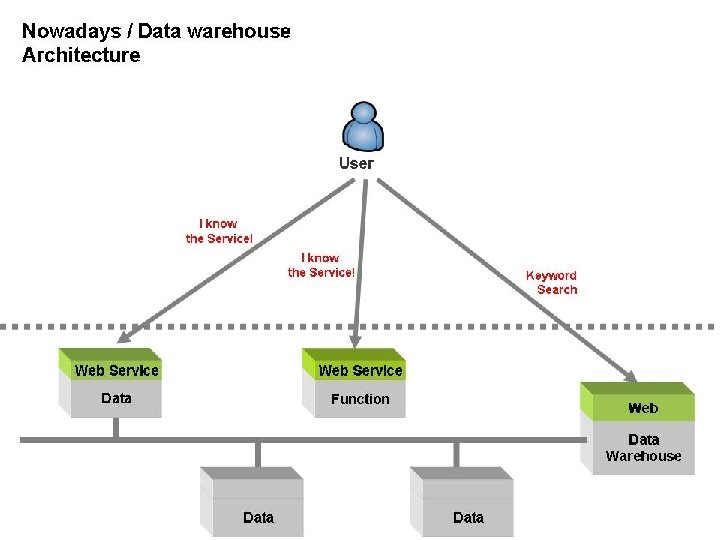
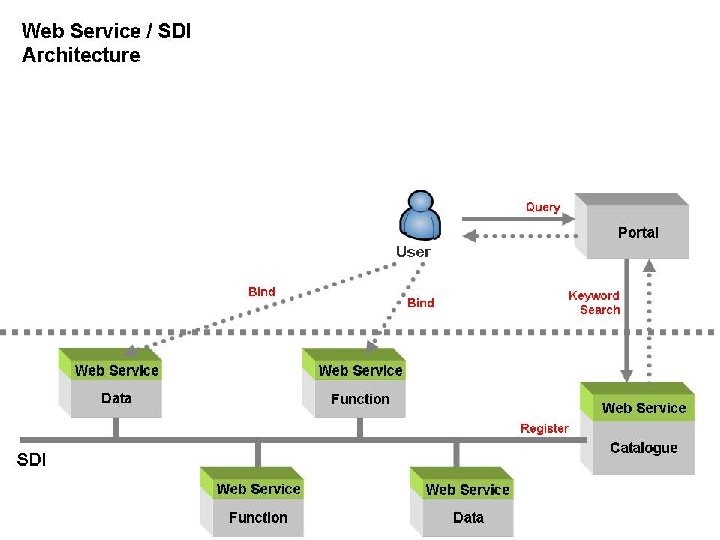
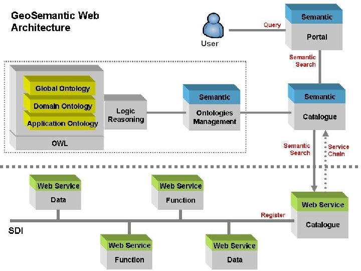
 TOCs Open. GIS 2006@Sinica 1. INTRODUCTION 1. 1 Motivations 1. 2 Objectives 2. BACKGROUND AND RELATED WORKS 2. 1 The semantic web 2. 2 Ontology 2. 3 Discover GIServices in SDI 3. THE FRAMEWORK OF GEOSEMANTIC WEB SERVICE Nowadays / Data Warehouse SDI / Web Services Semantic Web Services
 Open. GIS 2006@Sinica 1. INTRODUCTION
 Open. GIS 2006@Sinica NCGIA UCGIS 10 Challenges • Cognitive Models of Geographic Space • Cognition of Geo_ graphic Information • Computational Implementations of Geographic Concepts • Interoperability of Geographic Information • Geographies of the Information Society Motivation OGC Interoperability Three problems: • Syntactic GIServices: • WFS • WMS • Structure • WCS • Semantic • WPS • The Future of the Spatial Information Infrastructure Cognition、 Interoperability、 GIServices • CS
 Open. GIS 2006@Sinica Motivation
 Open. GIS 2006@Sinica Introduction • Applied Ontology into the architecture of SDI • Build a Geo. Semantic Web (service) • Apply a Domain knowledge to prove the concept!
 Open. GIS 2006@Sinica 2. RELATED WORKS
 Related Works Open. GIS 2006@Sinica • Semantic Web – – What is semantic web? – Components of semantic web – • Semantic problems Geospatial semantic web Ontologies – Ontology – The architecture of ontologies – Ontology languages – • Domain Knowledge Geospatial ontologies Ontology Reviews Discover GIService on SDI – SDI (Spatial Data Infrastructure) – Web services – GIServices – • Semantic Web Discover GIServices on SDI Domain Knowledge GIServices SDI
 Open. GIS 2006@Sinica 2. 1. Semantic Web
 Open. GIS 2006@Sinica • 譬如:「台大裡的醉月湖」 Semantic Problems
 Open. GIS 2006@Sinica Semantic Problems
 Real world Concept 4 Concept 2 Concept") Semantic Problems Open. GIS 2006@Sinica Mark, David(2005) Real world Concept 4 Concept 2 Concept 1 “mountain” Concept 5 Concept 3 “montaña” “mont” “berg” Words in different languages “ ”
Semantic Problems Open. GIS 2006@Sinica Mark, David(2005) Real world Concept 4 Concept 2 Concept 1 “mountain” Concept 5 Concept 3 “montaña” “mont” “berg” Words in different languages “ ”
 Open. GIS 2006@Sinica Semantic Problems Brodeur et al. , 2003
 Open. GIS 2006@Sinica • Semantic Problems Naming Heterogeneity: – Two data with the same data type and refer to the same domain concept, but have different names. • Data Type Heterogeneity: – Two data with the same name and refer to the same domain concept, but represented with different data types. • Conceptual Heterogeneity: – Two data with the same name and data type, but refer to different domain concepts.
 Open. GIS 2006@Sinica • Semantic Web What is Semantic Web ? – an extended web of machine-readable information and automated services that amplify the Web far beyond current capabilities
 Open. GIS 2006@Sinica • Components of Semantic Web
 Open. GIS 2006@Sinica Geo. Semantic Web • UCGIS considered that the geospatial semantic web would be one of critical research priorities for geographic information science (Fonseca, 2002). • The Geospatial Semantic Web is to capture, analyze and tailor geospatial information, much beyond the purely lexical and syntactic level which needs (Egenhofer, 2002): – Geospatial Ontology – Representation – match • OGC (Open Geospatial Consortium): – GML (Geography Markup Language): xml-based – WFS (Web Feature Services), WMS (Web Map Services)…
 Open. GIS 2006@Sinica 2. 2. Ontologies
 Open. GIS 2006@Sinica • Ontology – Philosophy: • the nature and the organization of reality. – Information Science: • an explicit specification of a conceptualization. – Classes – relations Ontologies
 Open. GIS 2006@Sinica Ontologies http: //lsdis. cs. uga. edu/~farshad/events/Event. Schema. png
 Open. GIS 2006@Sinica • Ontologies Ontology languages – Ontology languages allow users to write explicit, formal conceptualizations of domain models which include following main requirements: • well-defined syntax • formal semantics • Convenience of expression and sufficient expressive power • Efficient reasoning support – Class membership: x is an instance of a class C, and C is a subclass of D, then if we can infer that x is an instance of D. – Equivalence of classes: A → B and B → C, then A → C. if – Consistency: x is an instance of class A, and A is a subclass of B∩C, A is a if subclass of D, and B and D are disjoint. – Classification: we have declared that certain property-value pairs are a if sufficient condition for membership in a class A, then if an individual x satisfies such conditions, we can conclude that x must be an instance of A.
 specified by") Open. GIS 2006@Sinica • Ontologies Ontology languages – OWL (Web Ontology Language) specified by W 3 C = DARPA + OIL • • formal semantics • Convenience of expression and sufficient expressive power • • well-defined syntax Efficient reasoning support OWL Software – Protégé (http: //protege. stanford. edu/) – RACER (http: //www. sts. tu-harburg. de/~r. f. moeller/racer/)
Open. GIS 2006@Sinica • Ontologies Ontology languages – OWL (Web Ontology Language) specified by W 3 C = DARPA + OIL • • formal semantics • Convenience of expression and sufficient expressive power • • well-defined syntax Efficient reasoning support OWL Software – Protégé (http: //protege. stanford. edu/) – RACER (http: //www. sts. tu-harburg. de/~r. f. moeller/racer/)
 Open. GIS 2006@Sinica • Ontologies Geospatial Ontologies – Different spatial Cognition → Different spatial concept. Fonseca et al. (2002)
 Open. GIS 2006@Sinica • Ontologies Geospatial Ontologies – 認知空間中什麼樣的知識、 classes、 relations
 Open. GIS 2006@Sinica • The architecture of Ontologies
 Open. GIS 2006@Sinica 2. 3. Discover GIService on SDI
 Open. GIS 2006@Sinica. Discover GIServices on SDI • SDI – a multi-levelled, scalable, and adaptable collection of technical and human services, which are interconnected across system, organizational, and administrative boundaries via standardized interfaces. GIS for the Nation (2006)
 Open. GIS 2006@Sinica. Discover GIServices on SDI • Web services – a networked application that is able to interact using standard application-to-application.
 Open. GIS 2006@Sinica. Discover GIServices on SDI • GIService – network-based geographic information services that utilize both wired and wireless Internet to access geographic information, spatial analytical tools and other GIS resources. – GIS Data Access services & Geo-processing services • OGC – WFS (Web Feature Service) – WMS (Web Map Service) – WPS (Web Processing Service) – CS (Catalogue Service)
 Open. GIS 2006@Sinica. Discover GIServices on SDI • WMS example http: //140. 112. 64. 249/wmsconnector/com. esri. wms. Esrimap? Service. Name=WGS 84_M xd_Taipei
 Open. GIS 2006@Sinica. Discover GIServices on SDI • Discover GIServices on SDI – In previous literatures, there are two main parts used ontology applied into SDI: • Discovering GIServices (Bernald et al. , 2003; Bernard, Einspanier, Haubrock et al. , 2003; Probst and Lutz, 2004; Klien, Lutz, and Kuhn, 2006; Lemmens, 2006; Lutz, 2006) • Using ontology for semantic interoperability composes (Bernard, Einspanier, Lutz et al. , 2003; Einspanier et al. , 2003; Probst and Lutz, 2004; Lutz, 2006)
 Open. GIS 2006@Sinica. Discover GIServices on SDI • Discover GIServices on SDI Lutz, 2006
:") Domain Knowledge Open. GIS 2006@Sinica • Not decided yet. • Scenario: Geomorphology – 溶洞(石灰岩洞、鐘乳石洞): 雨水 或 地下水溶解侵蝕石灰岩 穴。 – Classes: 雨水、地下水、石灰岩、洞穴 – Relationships: 溶解侵蝕 Data 地下水 GIS Data Index GML WFS WFS Data shp 所形成的 洞 Functions 溶解 侵蝕 Analysis A 石灰岩 Analysis B Analysis C
Domain Knowledge Open. GIS 2006@Sinica • Not decided yet. • Scenario: Geomorphology – 溶洞(石灰岩洞、鐘乳石洞): 雨水 或 地下水溶解侵蝕石灰岩 穴。 – Classes: 雨水、地下水、石灰岩、洞穴 – Relationships: 溶解侵蝕 Data 地下水 GIS Data Index GML WFS WFS Data shp 所形成的 洞 Functions 溶解 侵蝕 Analysis A 石灰岩 Analysis B Analysis C
 Open. GIS 2006@Sinica 3. The framework of Geo. Semantic Web Services
 Open. GIS 2006@Sinica Conclusion • The Geo. Semantic web focuses on geospatial domain to extract explicitly geospatial knowledge that is used multi-level ontologies to manage. • Geo. Semantic interoperability will be the major research for users to discover GIS data or GIServices more accurate in SDI. • In the future, a Geo-domain knowledge would be applied into the architecture of Geo. Semantic web to evaluate the efficiency and accuracy.
 Open. GIS 2006@Sinica Contact me : Calvin C. JUNG 榮峻德 d 94228001@ntu. edu. tw http: //ediyacoo. googlepages. com Thank You ~ ! Questions ?