
Oil and Gas Opportunities in Alaska State of


- Размер: 30 Mегабайта
- Количество слайдов: 101
Описание презентации Oil and Gas Opportunities in Alaska State of по слайдам
Oil and Gas Opportunities in Alaska State of Alaska Department of Natural Resources Division of Oil and Gas 550 West 7 th Avenue, Suite 800 Anchorage, AK 99501 -3560 Phone: (907) 269 -8800 May 2005 http: //www. dog. dnr. state. ak. us/oil/ Alaska Department of Natural Resource s
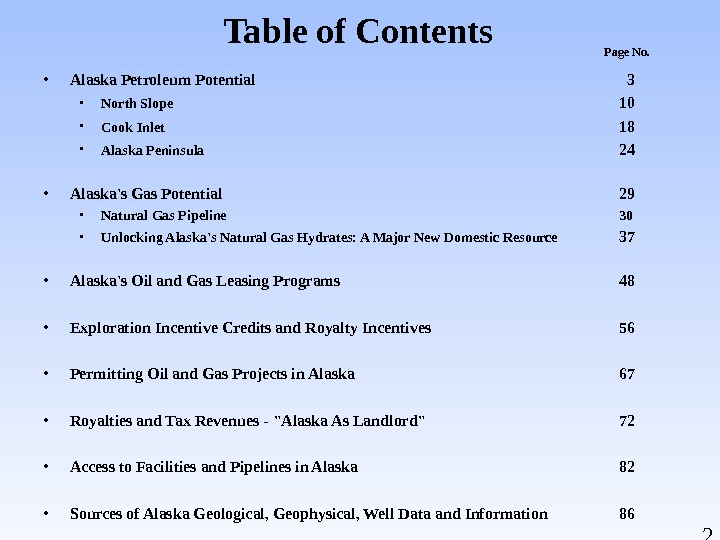
2 Table of Contents • Alaska Petroleum Potential 3 • North Slope 10 • Cook Inlet 18 • Alaska Peninsula 24 • Alaska’s Gas Potential 29 • Natural Gas Pipeline 30 • Unlocking Alaska’s Natural Gas Hydrates: A Major New Domestic Resource 37 • Alaska’s Oil and Gas Leasing Programs 48 • Exploration Incentive Credits and Royalty Incentives 56 • Permitting Oil and Gas Projects in Alaska 67 • Royalties and Tax Revenues — «Alaska As Landlord» 72 • Access to Facilities and Pipelines in Alaska 82 • Sources of Alaska Geological, Geophysical, Well Data and Information 86 Page No.
3 Alaska Petroleum Potential Alaska Department of Natural Resource s. State of Alaska Department of Natural Resources Division of Oil and Gas
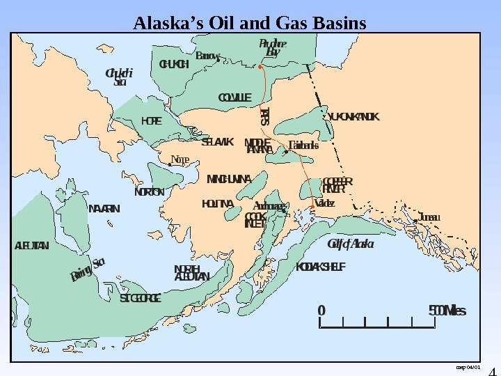
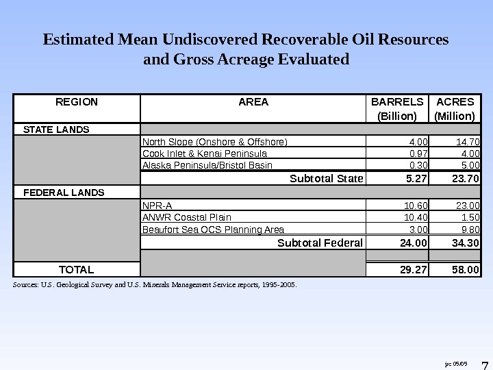
4 Alaska’s Oil and Gas Basins mep 04/
5 DO&G 01/
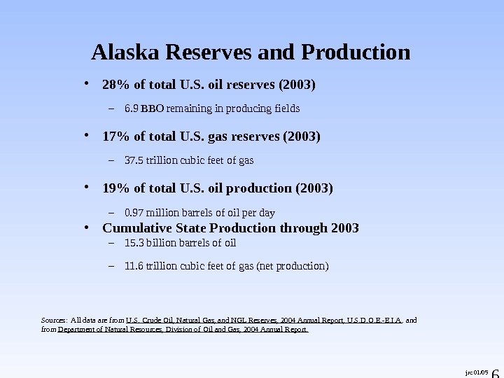
6 • 28% of total U. S. oil reserves (2003) – 6. 9 BBO remaining in producing fields • 17% of total U. S. gas reserves (2003) – 37. 5 trillion cubic feet of gas • 19% of total U. S. oil production (2003) – 0. 97 million barrels of oil per day • Cumulative State Production through 2003 – 15. 3 billion barrels of oil – 11. 6 trillion cubic feet of gas (net production)Alaska Reserves and Production Sources: All data are from U. S. Crude Oil, Natural Gas, and NGL Reserves, 2004 Annual Report, U. S. D. O. E. -E. I. A. and from Department of Natural Resources, Division of Oil and Gas, 2004 Annual Report. jrc 01/
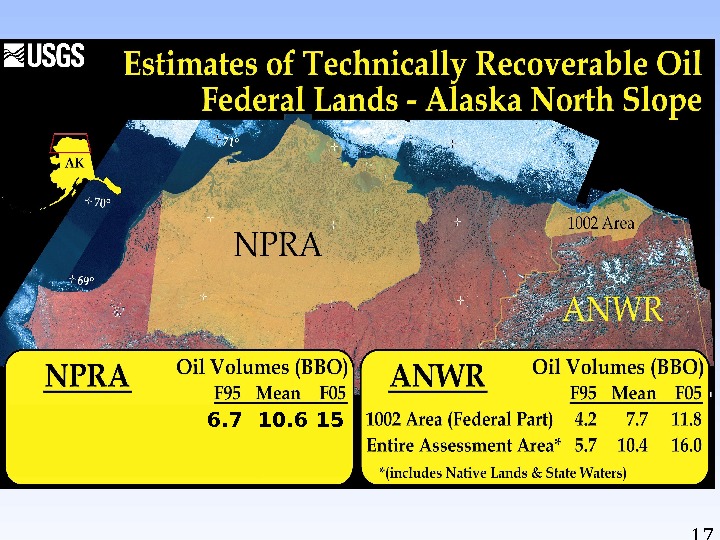
7 Estimated Mean Undiscovered Recoverable Oil Resources and Gross Acreage Evaluated jrc 05/05 Sources: U. S. Geological Survey and U. S. Minerals Management Service reports, 1995 -2005. REGION AREA BARRELS (Billion) ACRES (Million) STATE LANDS North Slope (Onshore & Offshore) 4. 00 14. 70 Cook Inlet & Kenai Peninsula 0. 97 4. 00 Alaska Peninsula/Bristol Basin 0. 30 5. 00 Subtotal State 5. 27 23. 70 FEDERAL LANDS NPR-A 10. 60 23. 00 ANWR Coastal Plain 10. 40 1. 50 Beaufort Sea OCS Planning Area 3. 00 9. 80 Subtotal Federal 24. 00 34. 30 TOTAL 29. 27 58.
8 Historic and Projected Oil Production 1969 -2022 beh/tjr 12/04 North Slope Historic and Projected Oil Production 1969 — 20220. 00. 51. 01. 52. 02. 5 1958 1962 1966 1970 1974 1978 1982 1986 1990 1994 1998 2002 2006 2010 2014 2018 2022 Millions of Barrels per Day NPRA Other North Slope Pt Thomson Unit Badami Northstar Colville River Duck Island Unit Milne Point Unit KRU IPA+Sat Greater Pt Mc. Intyre Area PBU IPA+Sat
9 Wood Mackenzie Study • Alaska ranked in top 25 percent for discovery size (99 MMBOE). • Alaska ranked in top half for commercial success rate (18 percent) and reserves recovered (918 MMBOE). • Alaska ranked in top quartile of “post-take development and full cycle NPV/BOE” ($2. 14/BOE). • Alaska ranked in top third of “absolute full cycle value created” ( $1. 97 B). Source: Petroleum News, February 20, 2005 Photo: Offshore Exploratory Well, Courtesy of Armstrong Oil and Gas
10 North Slope
11 sin
12 Generalized Geologic Evolution of Northern Alaska. Sediment Source Franklinian Sequence Ellesmerian Sequence Beaufortian\Rift Sequence Brookian Sequence E F R B NORTHSOUTH A. El lesmer ian B. Rift C. Brookian Middle (? ) Devoni an — Ear ly Cretaceous Jurassic — Ear ly Cretaceous Earl y Cretaceous — Tertiary Arcti c Ala ska Basi n E F EF FE BBR R B ? BRRRR Northern Terran e Basement Br ooks Range Col vi l le Trough Colvi lle Trou gh Hinge. Line. Modern. Shelf Edge Canada. Basin Ocea ni c Crust Source: Craig and ot hers, 1985 DO& G 3/ 97 ? Barrow. Arch. Brook s R ange Ri ft Zone Bas ement Complex Co mpl ex. Sea Level Sea Le vel NORTHSOUTH A. El lesmer ian B. Rift C. Brookia n Middle (? ) Devoni an — Early Cretaceous Jurassic — Early Creta ceous Earl y Cretaceous — Terti ary Arcti c Ala ska Basi n E F EF FE BBR R B ? BRRRR Northern Terran e Basement Br ooks Range Col vi l le Trough Colvi lle Trou gh Hinge. Line. Modern. Shelf Edge Canada. Basin Ocea ni c Crust Source: Craig and ot hers, 1985 DO& G 3/ 97 ? Barrow. Arch. Brook s Range Ri ft Zone Bas ement Complex Co mpl ex. Sea Level Sea Le vel
13 Generalized North Slope stratigraphic column displaying oil and gas reservoirs and associated accumulations
14 North Slope Oil & Gas Activities & Discoveries March
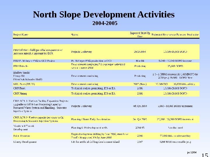
15 North Slope Development Activities 2004 -2005 jrc 12/
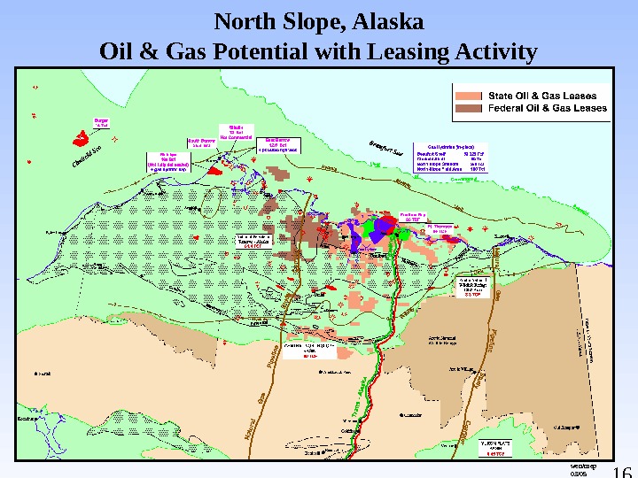
16 North Slope, Alaska Oil & Gas Potential with Leasing Activity wen/mep 03/
176. 7 10.
18 Cook Inlet
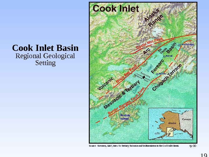
19 tjr 00 Cook Inlet Basin Regional Geological Setting Source: Swensen, 1997, Intro. To Tertiary Tectonics and Sedimentation in the Cook Inlet Basin.
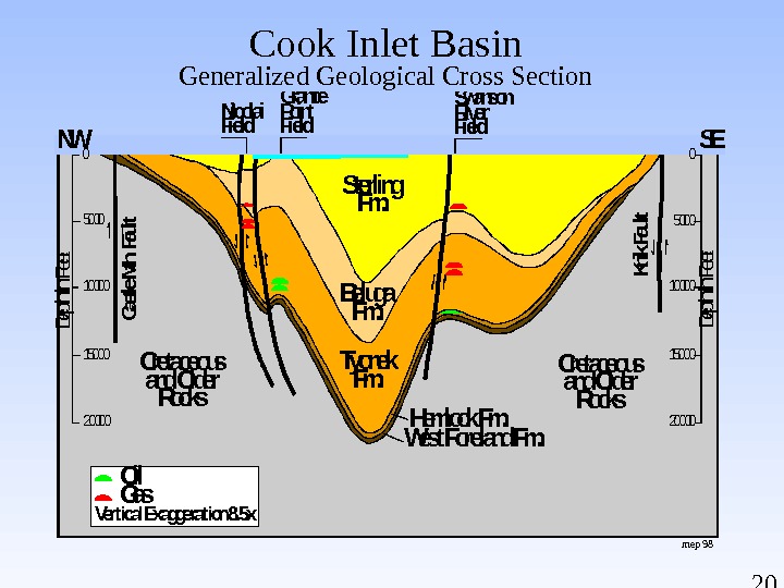
20 Hemlock Fm. Sterling Fm. Beluga Fm. Tyonek Fm. Cretaceous and Older Rocks West Foreland Fm. NW SEDepth in Feet Castle Mtn. Fault. Nicolai Field Granite Point Field Swanson River Field Knik Fault 5000 100000 0 15000 20000 Gas. Oil Vertical Exaggeration 8. 5 x mep 98 Cook Inlet Basin Generalized Geological Cross Section
21 Cook Inlet Oil & Gas Activities & Discoveries December 2004 jrc/cjb 12/
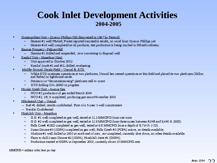
22 db/jrc 12/04 MMCF/D = million cubic feet per day • Cosmopolitan Unit – Conoco Phillips (Oil discovered in 1967 by Penzoil) – Hansen #1 well P&Aed, Forest reported successful results, no word from Conoco Phillips yet – Hansen #1 A well completed as oil producer, test production is being trucked to Nikisiki refinery. • Iliamna Prospect – Pelican Hill – Iliamna #1 drilled and suspended, now converting to disposal well • Kasilof Unit – Marathon (Gas) – Unit approved in October 2002 – Kasilof South #1 and #1 L drilled, evaluating • Middle Ground Shoals Field – Unocal & XTO – While XTO continues operations at two platforms, Unocal has ceased operations at this field and placed its two platforms (Dillon and Baker) in lighthouse mode. – Decision on “decommissioning” platforms still to come – XTO drilling C 31 -26 RD in progress • Nicolai Creek Unit – Aurora Gas – NCU #3 production of gas ended March 2004 – NCU #2, 1 B, 9 completed, producing gas since November 2003 • Nikolaevsk Unit – Unocal — Red #1 drilled, results confidential. First of a 5 -year 3 well commitment — Results Confidential • Ninilchik Unit – Marathon – G. O. #1 well completed as gas well, tested at 11. 2 MMCF/D from one zone – G. O. #2 well completed as gas well, tested at 11. 9 MMCF/D from three zones between 8, 048 and 9, 440 ft. (MD). – Falls Creek #1 RD completed as gas well, tested at 6. 8 MMCF/D from a depth of 8, 714 ft. (<D). – Susan Dionne #3 (SDPA) completed as gas well; Falls Creek #3 (FCPA) active, no details available. – Abalone #1 well drilled in 2003 at north end of unit, not completed, currently shut down, no other details available. – Plans to drill Susan Dionne #2 (SDPA), Ninilchik State #1 (GOPA). – Production started at GOPA in Septmeber 2003, currently about 15 MMCF/D rate. Cook Inlet Development Activities 2004 —
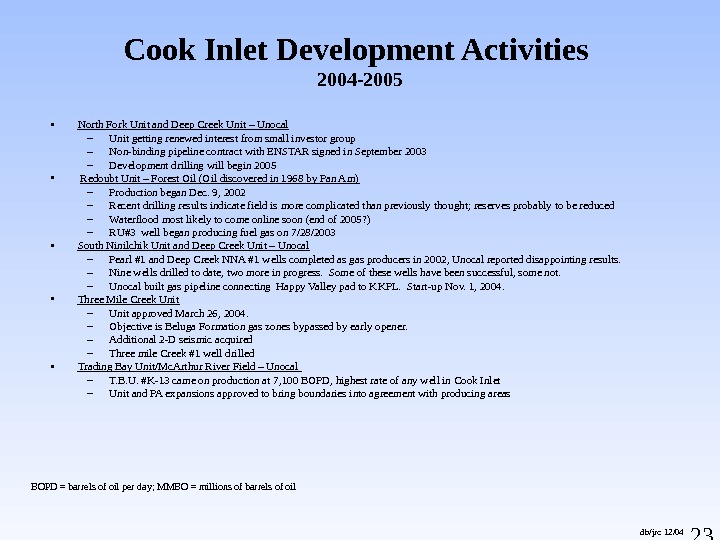
23 db/jrc 12/04 BOPD = barrels of oil per day; MMBO = millions of barrels of oil • North Fork Unit and Deep Creek Unit – Unocal – Unit getting renewed interest from small investor group – Non-binding pipeline contract with ENSTAR signed in September 2003 – Development drilling will begin 2005 • Redoubt Unit – Forest Oil (Oil discovered in 1968 by Pan Am) – Production began Dec. 9, 2002 – Recent drilling results indicate field is more complicated than previously thought; reserves probably to be reduced – Waterflood most likely to come online soon (end of 2005? ) – RU#3 well began producing fuel gas on 7/28/2003 • South Ninilchik Unit and Deep Creek Unit – Unocal – Pearl #1 and Deep Creek NNA #1 wells completed as gas producers in 2002, Unocal reported disappointing results. – Nine wells drilled to date, two more in progress. Some of these wells have been successful, some not. – Unocal built gas pipeline connecting Happy Valley pad to KKPL. Start-up Nov. 1, 2004. • Three Mile Creek Unit – Unit approved March 26, 2004. – Objective is Beluga Formation gas zones bypassed by early opener. – Additional 2 -D seismic acquired – Three mile Creek #1 well drilled • Trading Bay Unit/Mc. Arthur River Field – Unocal – T. B. U. #K-13 came on production at 7, 100 BOPD, highest rate of any well in Cook Inlet – Unit and PA expansions approved to bring boundaries into agreement with producing areas Cook Inlet Development Activities 2004 —
24 Alaska Peninsula
25 Alaska Peninsula Geologic Map dwb 09/03¨ ¨ ¨ ¨ ¨ ª ¨ ¨¨ ¨ Å Å ¨ BB B ø A ÿ A B B B ÿ AB B B BB BB B B B** * * BB B $ B B B * B BB BBB B Bø A B BBB$ B Bearing Sea Bristol Bay Basin Exploration License Area Proposed Alaska Peninsula Areawide Oil and Gas Lease Sale Area LEE PEARL NO. 2 NO. 1 NO. 2 NO. 4 NO. 3 NO. 2 NO. 1 ALASKA GRINER UGASHIK MCNALLY LATHROP GRAMMER DRY BAY BECHAROF FINNEGAN COSTELLO BIG RIVER ANCHOR PT PAINTER CK GREAT BASINS BEAR CK UNIT WIDE BAY UNIT STARICHKOF ST SANDY RIV FED OCS 0454(FERN) OCS 0161(HAWK) CANOE BAY UNIT NINILCHIK UNIT OCS 0113(IBIS) OCS 0136(BEDE) OCS 0168(COHO) OCS 0086(GUPPY) OCS 0097(RAVEN) OCS 0466(BERTHA) DAVID RIVER USA PORT HEIDEN UNIT OCS 0243(FALCON) OCS 0124(S ARCH) OCS 0511(SEGULA 1) OCS 0477(CAMELOT) OCS 0152(BOWHEAD) OCS 0527(TUSTMNA 2) OCS 0530(TUSTMNA 1) OCS 0248(CARDINAL) STARICHKOF ST UNIT OCS 0248(CARDINAL) OCS 0463(MONKSHOOD)OCS 7611 COST-ST GRGE OCS 8218 COST N ALTN OCS 77 -01(KSSD-KOD) OCS 76 -35(KSST-KOD)KONIAG CHEVRON USA HOODOO LK UNIT USA 7705 CST-LWER CK IN OCS 8219 COST-ST GRGE CATHEDRAL RIVER UNIT OIL SEEP R OIL SEEP GAS SEE P GAS SEEP OIL SEEP R OIL SEEP D OIL SEEP A, R OIL SEEP A, D OIL SEEP A, UOIL SEEP A, R OIL-BEARING OUTCROP OIL-BEAR ING OUTCROP Unga Ekuk Uyak Sanak Ekwok Egegik. Kipnuk Togiak Naknek Kodiak Uganik Akhiok. Karluk Ugashik Chignik Iliamna Igiugig Chiniak. Afognak Kaguyak. Ayakulik Cold Bay Newhalen Kokhanok Platinum Portlock Levelock Ouzinkie Belkofski King Cove Nondalton Koliganek. Quinhagak Aleknagik Manokotak Pedro Bay Perryville. Ivanof Bay Sand Point False Pass Kongiganak Womens Bay. Port Lions Old Harbor. Larsen Bay. Pilot Point Port Heiden Port Moller King Salmon Chignik Lake Squaw Harbor New Stuyahok. Kwigillingok Goodnews Bay South Naknek Nelson Lagoon Port Alsworth Portage Creek Clark’s Point Chignik Lagoon OIL SEEP GAS SEEP OIL SEEP 165° 0’0″W 160° 0’0″W 155° 0’0″W 55° 0’0″N 60° 0’0″N ! ! ! ^ _ !!!!! ! ! !Nome Sitka Kodiak. Bethel Barrow Valdez Juneau Cold Bay Fairbanks Anchorage Dillingham S e p t ,
26 Alaska Peninsula Geologic Cross Section
27 Alaska Peninsula/ Bristol Bay Basin Hydrocarbon Potential • Numerous oil seeps are present along the southern half of the Alaska Peninsula. • 26 wells have been drilled onshore since 1903, the latest being the Amoco Becharof #1 in 1985. One offshore stratigraphic test was drilled in 1983, the ARCO North Aleutian COST Well #1. • The northern half of the Alaska Peninsula is a low relief coastal plain underlain by a thick sequence (18, 000+ feet) of Tertiary strata that is contiguous with the Bristol Bay Basin to the north. Here the setting is very good for both structural and stratigraphic traps as well as the likelihood of encountering good to locally excellent reservoir quality rocks.
28 • Reservoir quality should be considered the highest risk as rocks derived from volcanic and plutonic source areas may give rise to pore plugging cements and clays. • Oil and gas shows are evident in many of the wells. No commercial flow of oil has been proven to date. • Hyrdocarbon source rocks of Tertiary age appear to be largely gas prone. Deeper Mesozoic strata may have both gas and oil generating potential. • Seismic control on the Alaska Peninsula is largely poor and archaic. Latest technology in seismic acquisition and processing is needed to further define prospects. Alaska Peninsula/ Bristol Bay Basin Hydrocarbon Potential (cont. )
29 Alaska’s Gas Potential Alaska Department of Natural Resource s. State of Alaska Department of Natural Resources Division of Oil and Gas
30 Natural Gas Pipeline
31 Projected North American Gas Demand Supply Source: NPC Study (2004) wen/mep 03/
32 jrc 05/05 Mean Value, Total Natural Gas Reserve and Resource Base for Gas Pipeline Supply Report All Values Trillions of Cubic Feet (TCF) Alaska Division of Oil and Gas (01/12/05) N/A = Not Assessed 1 Current estimate of known «stranded» recoverable North Slope conventional gas reserves in Prudhoe Bay, Point Thomson and smaller fields. 2 Subcategory of and included in «Undiscovered Technically Recoverable Conventional Reserves». Represents Basin Deep or Basin Centered component > 15, 000′ depth. 3 Craig and Sherwood arbitrarily split offshore hydrate resource estimates between Beaufort and Chukchi Sea shelves. Total North Alaska offshore gas hydrate potential remains 32, 375 tcf. 4, 5 Geological Survey of Canada estimated mean undiscovered gas in place ~ 0. 489 — 0. 800 TCF. Alaska component estimated as 0. 116 Tcf. 8 Includes nonassociated and associated gas. State and Native lands are estimated to be approximately 37. 5 TCF and are included in this total. 9 Oil and Gas Assessment of Yukon Flats, East-Central Alaska, 2004, USGS Fact Sheet 2004 -3121, December 2004. 7 Barker, C. E. , Clough, J. G. , Roberts, S. B. , and Fisk, R. , Coalbed methane in Northern Alaska: potential resources for rural use and added supply for the proposed trans-Alaska gas pipeline; AAPG-SPEM Joint Technical Conference, Anchorage, AK, May 2002. 6 Collett, personal communication, 11/26/04. After Craig, J. , and Sherwood, K. , Prospects for development of Alaska natural gas: a review as of January 2001, Minerals Management Service, Alaska Region. tbl. 9, p. 76. Modified to include only North and Central Alaska basins and updated to include new information as footnoted. 4 1995 National Assessment of United States Oil and Gas Resources, U. S. Geological Survey, Open File Report , Digital Data Series-30, pub. 1995. For all central Alaska basins except the Kandik Basin. Other basins not evaluated individually. BASIN KNOWN RISKED GAS COALBED BASIN RESERVES UNDISCOVERED HYDRATES METHANE TOTAL CONVENTIONALLY IN PLACE RECOVERABLE RESOURCE 6 RESOURCE DEEP GAS RESOURCE 2 NORTH ALASKA (onshore) 35. 000 1 119. 200 8 17. 700 2 590. 000 6 800. 000 7 1, 544. 200 NORTH ALASKA (Beaufort shelf) 2 0. 000 32. 070 N/A 32, 325. 000 3 N/A 32, 357. 070 NORTH ALASKA (Chukchi shelf) 2 0. 000 60. 110 N/A 50. 000 3 N/A 110 CENTRAL ALASKA 4 0. 000 2. 760 N/A N/A 2. 760 YUKON FLATS 9 0. 000 5. 460 N/A N/A 5. 460 KANDIK 5 0. 000 0. 116 N/A 0. 116 NENANA/TANANA 0. 000 N/A N/A N/A COPPER RIVER 0. 000 N/A N/A N/A TOTAL BY GAS TYPE 35. 000 1 219. 716 17. 700 2 32, 965. 000 800. 000 7 34, 019.
33 Prudhoe Bay Production & TAPS Schematic. Flow Legend SLP (Crude Oil & Condensate) Gas Water DO&G 10/96 NGLs Diesel Sales Unit & PA Production Commingled TAPS Production Well Fluids (Oil, Water, & Gas) Pump Station Drillsite and Well Pads PS # 1 Skid 50 Separation Facility. Manifold Building Topping Plant TAPSSeawater Treatment Plant Seawater Injection Well (Seawater) Injection Well (MI Gas) Injection Well (Lean Gas) Injection Well (Produced Water) Injection Well (Lean Gas) Production Well (Well Fluids & Gas Lift Gas)Produced Water Well Fluids Gas Lift Gas NGLs SOG Lean Gas. Field Fuel Gas & Gas Sales Diesel Sales IPA Production. SLPMI Gas Central Gas Facility Central Compressor Plant Kuparuk River Production Milne Point Production Greater Pt. Mc. Intyre Area Production Endicott Production Beaufort Sea Oil Rim Valdez Original Gas Cap Expanded Gas Cap Rock Water
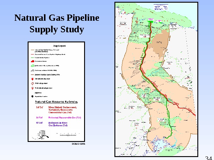
34 Natural Gas Pipeline Supply Study DO&G 03/
35 Useful Life of a Gas Pipeline mdm 07/04 Project Life (Years) Pipeline Capacity BCF/Day (4. 5) (5. 6)Reserves (Tcf) Known Resources Undiscovered Resources 33 36 40 60 100 150 20. 1 21. 9 24. 36 36. 5 61. 5 91. 3 16. 1 17. 6 19. 6 29. 4 48. 9 73.
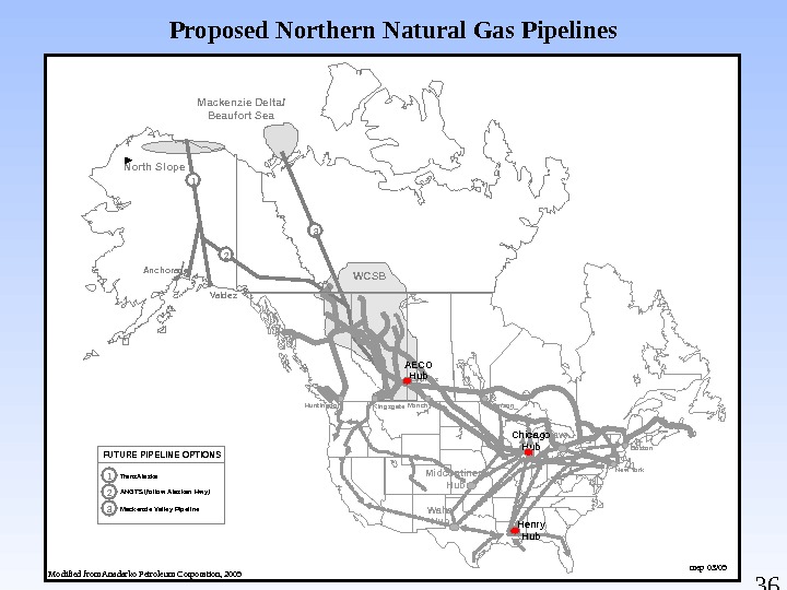
36 ANGTS (follow Alaskan Hwy)FUTURE PIPELINE OPTIONS Mackenzie Valley Pipeline. Trans. Alaska 1 2 3 Anchorage. North Slope Valdez WCSBMackenzie Delta/ Beaufort Sea 1 Monchy Emerson Daw n Hub. Huntingdon New York Boston. Kingsgate Empress Chicago Hub Waha Hub. Midcontinent Hub Henry Hub. AECO Hub 3 2 Proposed Northern Natural Gas Pipelines Modified from Anadarko Petroleum Corporation, 2005 mep 03/
Unlocking Alaska’s Natural Gas Hydrates: A Major New Domestic Resource Alaska Department of Natural Resource s. State of Alaska Department of Natural Resources Division of Oil and Gas
38 Federal Legislation Provides Project Substantial Benefits • Regulatory streamlining • Expedited judicial review • Loan guarantees • 7 -year accelerated depreciation • Investment tax credit for gas treatment plant
39 Resource Assessments • Alaska’s gas can make a huge contribution to reducing our nations dependence on foreign sources of energy. • Federal and state geologists believe that the 35 TCF of gas from Prudhoe Bay and Pt. Thomson is just the tip of the iceberg. • North Slope and offshore conventional mean technically recoverable undiscovered resource potential exceeds 236 TCF. • North Slope and offshore gas hydrate resource estimated in excess of 32, 000 TCF, of which 529 TCF is estimated to be onshore. • Gas hydrate resource in the Prudhoe/Kuparuk Milne Pt. field area alone is 100 TCF. • Gas hydrates first confirmed in 1972 drilling, coring and testing in the northwest corner of the Prudhoe Bay field, 5 years prior to field start-up. mdm 03/
40 Gas Potential — North Slope Area with Oil & Gas Leasing Activity wen/mep 03/
41 Gas Hydrates commonly occur in Arctic regions and deep ocean continental margins. is a crystalline substance composed of water and methane gas. The solid water lattice accommodates gas molecules in a cage-like structure. One cu. ft. of methane hydrate will contain as much as 164 cu. ft. of gas. represent a large world wide resource, 500 to 1, 200, 000 tcf of gas.
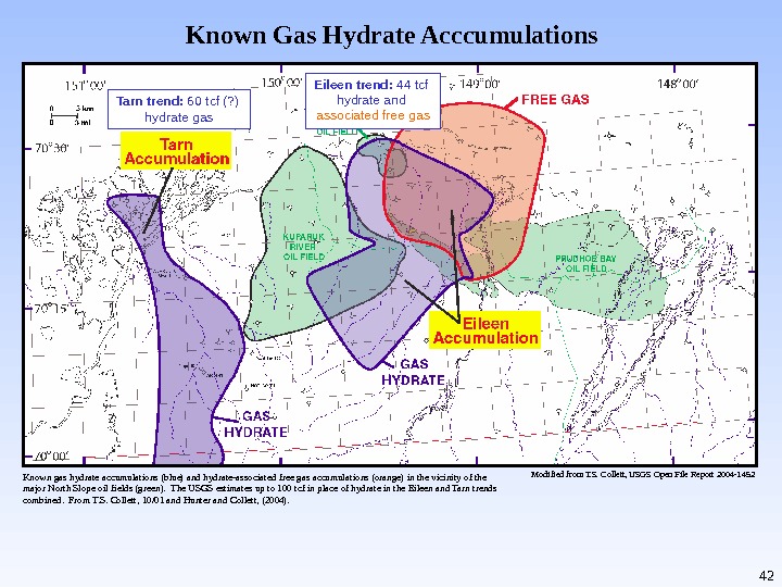
42 Known Gas Hydrate Acccumulations Modified from T. S. Collett, USGS Open File Report 2004 -1452 Eileen trend: 44 tcf hydrate and associated free gas. Tarn trend: 60 tcf (? ) hydrate gas Known gas hydrate accumulations (blue) and hydrate-associated free gas accumulations (orange) in the vicinity of the major North Slope oil fields (green). The USGS estimates up to 100 tcf in place of hydrate in the Eileen and Tarn trends combined. From T. S. Collett, 10/01 and Hunter and Collett, (2004).
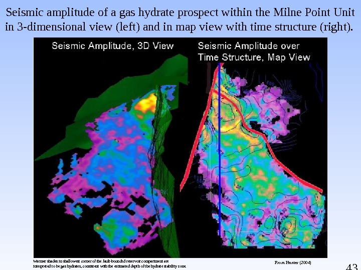
43 Seismic amplitude of a gas hydrate prospect within the Milne Point Unit in 3 -dimensional view (left) and in map view with time structure (right). From Hunter (2004)Warmer shades in shallowest corner of the fault-bounded reservoir compartment are interpreted to be gas hydrates, consistent with the estimated depth of the hydrate stability zone.
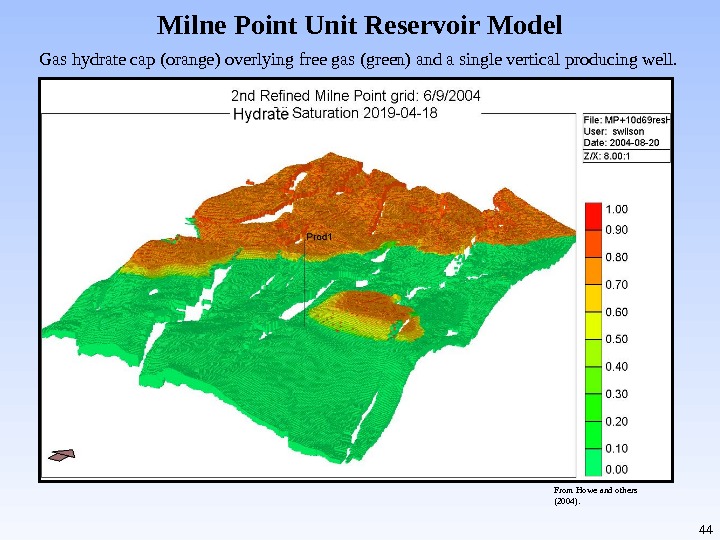
44 Milne Point Unit Reservoir Model Gas hydrate cap (orange) overlying free gas (green) and a single vertical producing well. From Howe and others (2004).
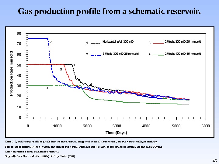
45 Gas production profile from a schematic reservoir. Cases 1, 2, and 3 compare offtake profile from the same reservoir using one horizontal, three vertical, and two vertical wells, respectively. Note extended plateau for one horizontal compared to two vertical wells, and that total flow in all scenarios is virtually the same after 15 years. Case 4 represents a lower permeability reservoir. Originally from Howe and others (2004) cited by Hunter (2004)
46 Graph showing modeled contribution of hydrates to total production for the reservoir model in Milne Point Unit reservoir model Production of original free gas constitutes all of the initial production; reservoir depressurization results in dissociation of overlying hydrates into free gas. In this particular simulation, dissociated hydrate gas accounts for nearly all production beyond the fifth year, and continues at a nearly constant rate for the next decade.
47 Methane Hydrate Research, Development and Field Operations — Authorization Budget
48 Alaska’s Oil and Gas Leasing Programs State of Alaska Department of Natural Resources Division of Oil and Gas Alaska Department of Natural Resource s
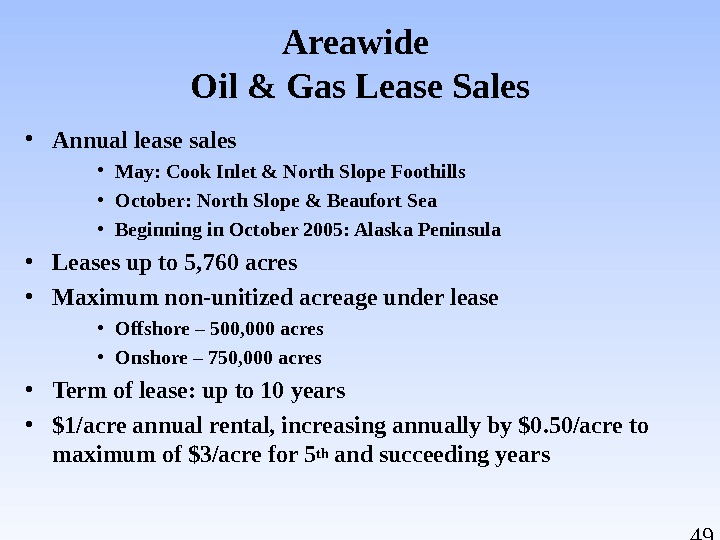
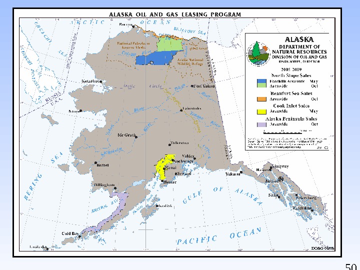
49 Areawide Oil & Gas Lease Sales • Annual lease sales • May: Cook Inlet & North Slope Foothills • October: North Slope & Beaufort Sea • Beginning in October 2005: Alaska Peninsula • Leases up to 5, 760 acres • Maximum non-unitized acreage under lease • Offshore – 500, 000 acres • Onshore – 750, 000 acres • Term of lease: up to 10 years • $1/acre annual rental, increasing annually by $0. 50/acre to maximum of $3/acre for 5 th and succeeding years
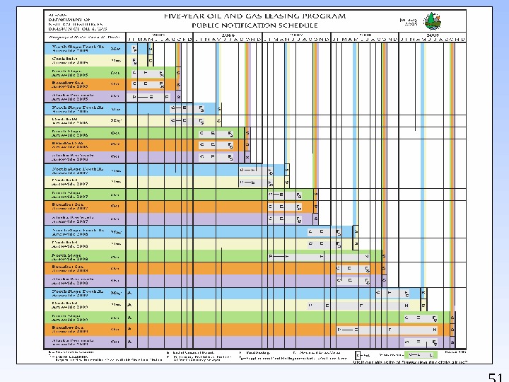
50 Five-Year Oil & Gas Leasing Program Public Notification Schedule DO&G 01/
51 Five-Year Oil & Gas Leasing Program Public Notification Schedule
52 Exploration Licensing • Proposals accepted during month of April • 10, 000 to 500, 000 acres • Maximum acreage under license: 2, 000 acres • Term of license: Up to 10 years • Work commitment, expressed in $$ • No rental fees during term of license • One-time $1/acre licensing fee • Right to convert to oil & gas leases
53 Exploration Licensing Program Issued Licenses Nenana Basin Susitna Basin Copper River Basin Susitna Basin License 1: Issued Licensee — Forest Oil Corp. 386, 207 Acres Susitna Basin License 2: Issued Licensee — Forest Oil Corp. 471, 474 Acres. Copper River License: Issued Licensee: Forest Oil. Corporation Size: 318, 756. 35 Acres Nenana Basin: Issued Licensee: Andex Resources Size: 483, 175 Acres ods/pb/pg 1/
54 Exploration Licensing Program Proposed Licenses Usibelli Coal Mine Inc. proposed a work commitment of $500, 000 with a 10 year term. Solicitation of Competing Proposals ended Dec. 9 (none received). Solicitation of Public Comments ended. Preliminary Best Interest Finding (June/July). Final Best Interest Finding (Fall 2005). Proposed Holitna Basin Exploration License Area. Proposed Healy Basin Exploration License Area Holitna Energy Co. converted from Shallow Natural Gas applications (Under HB 531). Solicitation of Public Comments (Ended Dec. 21). Preliminary Best Interest Finding (May/June 2005). Final Best Interest Finding (Fall 2005). ods/pb/pg 1/
55 Independents in Alaska Venture Capital Group, LLC Alliance Energy, LLC Anadarko Petroleum Corporation Andex Resources, LLC Armstrong Alaska, Inc Aurora Gas, LLC BBI, Inc. Burlington Resources Alaska, Inc. Cassandra Energy Corporation Devon Energy Production Company En. Cana Oil and Gas (USA), Inc. Evergreen Resources Alaska, Inc. Forest Oil Corporation Gas-Pro Alaska, LLC Lapp Resources, Inc. Murphy Exploration (Alaska), Inc Northstar Energy Group, Inc. Pioneer Natural Resources Alaska, Inc. Pioneer Oil Company Prodigy Alaska, LLC Rutter & Wilbanks Corp. Trading Bay Oil and Gas, LLC Ultrastar Exploration, LLC Union Oil Company of California Winstar Petroleum, LLC XTO Energy, Inc. pb 05/
56 Exploration Incentive Credits and Royalty Incentives Alaska Department of Natural Resource s. State of Alaska Department of Natural Resources Division of Oil and Gas
57 Exploration Incentive Credit (EIC) Programs Program. IAS 38. 05. 180(i)Oiland. Gas. Leasing Restricted to oil and gas leases, shallow gas leases and unleased state lands that will be offered for leasing within two years of the activity. Maximum of 50% of allowable drilling costs on conventional oil and gas leases. Maximum of 50% of allowable geophysical program costs on unleased state lands during the two years immediately preceding inclusion of those lands in an announced lease sale. Information must be made public following the lease sale. Applicable to royalty and rental payments and taxes owed the state under AS 43. 55. Credits may not exceed 50% of the payment toward which it is being applied. Credits may be assigned. Total drilling credits granted to-date: $54. 6 million
58 Exploration Incentive Credit (EIC) Programs Program II — AS 41. 09. 010 Exploration Incentive Credits Program expires July 1, 2007. Restricted to unleased lands, lands under exploration license, and federal and private lands. Up to 50% of allowable costs for activities on state lands. Up to 25% of allowable costs for activities on federal and private lands. $5 million maximum per project; $30 million maximum for program. Applicable to geophysical work NOT subject to AS 38. 05. 180(i) and to exploratory and stratigraphic test wells. Applicable to bonus bids, royalties, rental payments, and taxes. Credits may be assigned. Drilling data confidentiality term cannot exceed the normal two-year term. Geophysical data may be shown, but not transferred, to interested third parties.
59 Royalty Incentives • Royalty Reduction – as low as 5% if new production – as low as 3% if producing or shut-in – as low as 5% for oil production from CI platforms if production falls below specified levels • Discovery Royalty – CI only: 5% royalty for 10 yrs – Pre-1969 leases statewide: 5% royalty for 10 yrs.
60 Production Tax (ELF) — AS 43. 55 15% X Non-Royalty Production X ELF X Gross Value at Wellhead ELF: Factor between 0 and 1. 1 – Very BIG fields Prudhoe Bay: 450, 000 barrels/day 1 – Very PRODUCTIVE fields Alpine and Northstar: over 4, 000 barrels/well/day All other fields are close to 0. 150, 000 barrels/day fields with low productivity 2, 000 barrels/well/day fields with low volume Dan Dickinson, Department of Revenue, Tax Division
61 Exploration Tax Credits — AS 43. 55. 025 Production Tax Credit. Effective for exploration well and seismic and geophysical exploration activities conducted July 1, 2003, through June 30, 2007, except those included in a unit plan of development or plan of exploration on May 13, 2003. Applicable only to production occurring on or after July 1, 2004. Applicable to all unleased and leased state, federal and private land within the state. Credit is transferable. Exploration well tax credits: — 2 0% if the bottom hole location is 3 or more miles from the bottom hole location of a preexisting completed, suspended or plugged and abandoned oil or gas well that was spud more than 150 days, but less than 35 years, prior to spud date of the eligible exploration well. — 20% if the bottom hole location is 25 or more miles from the boundary as of July 1, 2003, of any unit under a plan of development. — 40% if both conditions are met. Seismic exploration tax credits: — 40% of eligible costs for those portions of activities outside of units under plan of development or plan of exploration. — Seismic data submitted to state will be held confidential for 10 years and 30 days following activity completion date. Dan Dickinson, Department of Revenue, Tax Division
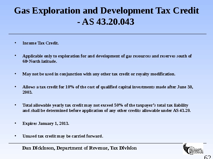
62 Gas Exploration and Development Tax Credit — AS 43. 20. 043 • Income Tax Credit. • Applicable only to exploration for and development of gas resources and reserves south of 68 o North latitude. • May not be used in conjunction with any other tax credit or royalty modification. • Allows a tax credit for 10% of the cost of qualified capital investments made after June 30, 2003. • Total allowable yearly tax credit may not exceed 50% of the taxpayer’s total tax liability and shall be determined before application of any other credits allowable under AS 43. 20. • Expires January 1, 2013. • Unused tax credit may be carried forward. Dan Dickinson, Department of Revenue, Tax Division
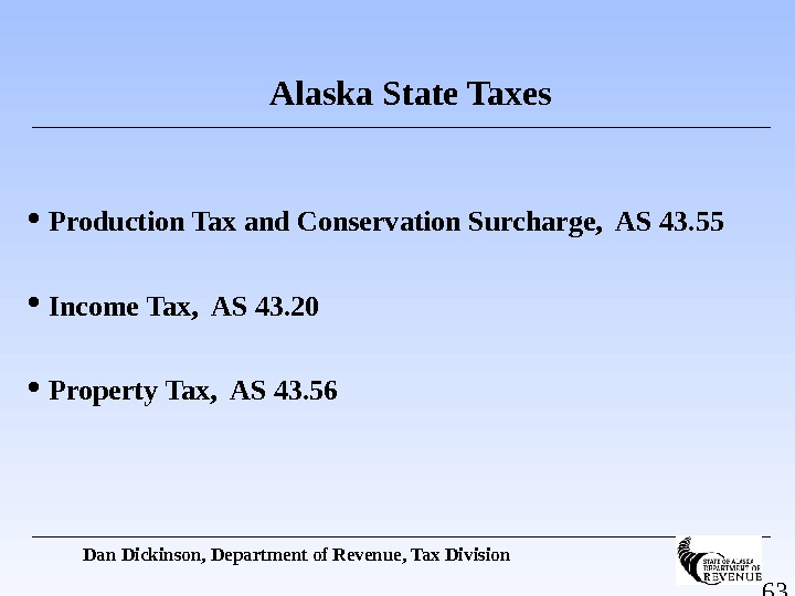
63 Alaska State Taxes Production Tax and Conservation Surcharge, AS 43. 55 Income Tax, AS 43. 20 Property Tax, AS 43. 56 Dan Dickinson, Department of Revenue, Tax Division
64 Property Tax — AS 43. 56 20 mills. Credit for any local assessment. Evaluation for Exploration property “is the estimated price that the property would bring in an open market and under then prevailing conditions in a sale between a willing seller and a willing buyer both conversant with the property and with prevailing price levels. ” Assessed as of January 1. Due in June. Also applies to production and pipeline properties. Dan Dickinson, Department of Revenue, Tax Division
65 Income Tax — AS 43. 20 Sliding scale up to 9. 5% on $100, 000 of income. Start with Federal taxable income. Three-factor Alaska apportionment to arrive at Alaska income. Payroll, property and sales. Once a producer, modified apportionment. Production replaces payroll. Unitary group. Dan Dickinson, Department of Revenue, Tax Division
66 Production Tax — AS 43. 55 15% X Non-Royalty Production X ELF X Gross Value at Wellhead 12. 25% for first 5 years of commercial production Gross value at wellhead is market value at destination less transportation costs to point of production tankering costs TAPS quality bank upstream pipelines Dan Dickinson, Department of Revenue, Tax Division
Permitting Oil and Gas Projects in Alaska Department of Natural Resource s. State of Alaska Department of Natural Resources Division of Oil and Gas
68 Permit Streamlining Accomplishments • Significantly revised the Alaska Coastal Management Program • Re-organized permitting agencies and consolidated responsibilities within the Department of Natural Resources (DNR) • Created large project permit office in the DNR • Clarified rules and procedures for Oil Spill Contingency Planning • Created Permit-by-Rule Air Quality Permitting
69 Measure of Progress • One Independent went from lease issuance to permits in hand for a North Slope off-shore well in 3 months. • Lease issued: August 12, 2002 • Permits Obtained: August 20, 2002 – November 15, 2002 • Ice Road Started: January 14, 2003 • First Well Spud: February 25,
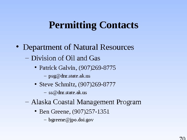
70 Permitting Contacts • Department of Natural Resources – Division of Oil and Gas • Patrick Galvin, (907)269 -8775 – psg@dnr. state. ak. us • Steve Schmitz, (907)269 -8777 – ss@dnr. state. ak. us – Alaska Coastal Management Program • Ben Greene, (907)257 -1351 – bgreene@jpo. doi. gov
71 Permitting Contacts • Department of Environmental Conservation – Oil Spill Contingency Planning • Bill Hutmacher (907) 269 -3054 – Bill_hutmacher@dec. state. ak. us – Air Quality Permitting • Jim Baumgartner (907) 465 -5108 – jim_baumgartner@dec. state. ak. us
Royalties and Tax Revenues «Alaska As Landlord» Alaska Department of Natural Resources. State of Alaska Department of Natural Resources Division of Oil and Gas
73 ALASKA: 570, 000 Square Miles 1. 48 Million Square Kilometers 365 Million Acres Majority of known petroleum reserves are on state-owned lands About 30% of proven U. S. oil reserves are located in Alaska krb 12/03 Alaska Land Ownership
74 Calculation of Alaska Royalty and Tax Revenues Prudhoe Bay Milne Point West Coast Destination Value 25. 00$ – Marine Transportation Cost 1. 25 – Pipeline Tariffs 2. 70 2. 91 + Quality Bank Payments 0. 31 (0. 29) – Royalty Field Cost Deduction 0. 83 — = Royalty or Severance Tax Value 20. 53$ 20. 55$ x Royalty or Severance Tax Barrels 28, 105 2, 500 = Royalty or Severance Tax Revenues 576, 995. 65$ 51, 375. 00$
75 Royalty is a Contract Right krb 12/
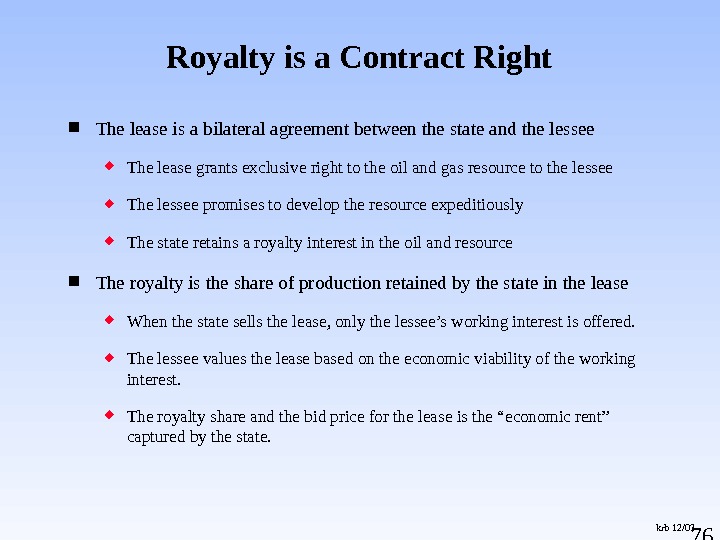
76 The lease is a bilateral agreement between the state and the lessee The lease grants exclusive right to the oil and gas resource to the lessee The lessee promises to develop the resource expeditiously The state retains a royalty interest in the oil and resource The royalty is the share of production retained by the state in the lease When the state sells the lease, only the lessee’s working interest is offered. The lessee values the lease based on the economic viability of the working interest. The royalty share and the bid price for the lease is the “economic rent” captured by the state. Royalty is a Contract Right krb 12/
77 The lease cannot be changed unilaterally by the state or the lessee. Modification of the lease royalty rates ex post is not a tool available to implement fiscal policy. Royalty is a Contract Right krb 12/
78 The royalty share is not : an entitlement to a share in the profits burdened by a share in the costs of production The royalty share is set by statute at a minimum of 12. 5% Many offshore Beaufort Sea leases are set at 16 -2/3% Some leases have sliding scale percentages based on price or gross revenues The lease royalty rate may be reduced under special circumstances The Royalty Share krb 12/
79 The state may take its royalty share in kind or in value When the state takes its Royalty-in-kind (RIK), it takes physical possession of the production and it may sell its royalty share to someone else. The state must take its oil and gas royalty share in kind unless the DNR commissioner determines that the taking in-value would be in the best interests of the state. The Royalty Share krb 12/
80 Royalty-in-Value When the state takes its royalty-in-value (RIV), the state has the right to a share of the value for which the production is sold. When the state takes its royalty-in-value (RIV), the lessee is obligated to use due diligence to market the state’s share. Royalty revenue to the state is calculated by multiplying the oil or gas price or value times the percentage rate specified in the lease times the total production from the lease The Royalty Share krb 12/
81 Royalty Oil Production and Total Royalty-In-Kind krb 12/03 Total ANS Royalty and RIK Sale s (include s Ne w Mapco Contract) 0 50, 000 100, 000 150, 000 200, 000 250, 000 300, 000 Year Barrels per Day T otal ANS R oyalty T otal ANS R IK Bbls
Access to Facilities and Pipelines in Alaska Department of Natural Resource s. State of Alaska Department of Natural Resources Division of Oil and Gas
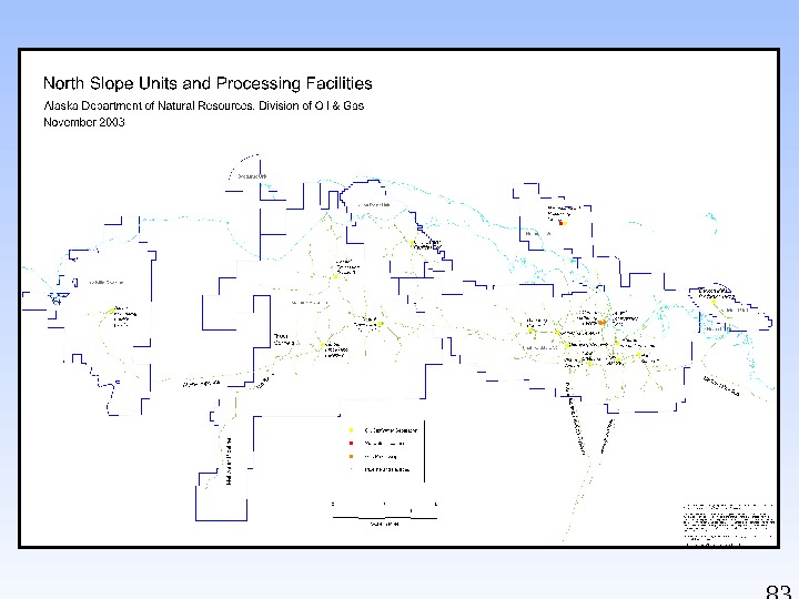
84 North Slope Oil & Gas Activities & Discoveries March
85 Cook Inlet Oil & Gas Activities & Discoveries December 2004 jrc/cjb 12/
Sources of Alaska Geological, Geophysical, Well Data and Information Alaska Department of Natural Resource s. State of Alaska Department of Natural Resources Division of Oil and Gas
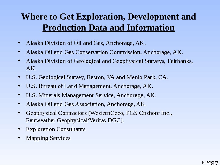
87 jrc 12/03 Where to Get Exploration, Development and Production Data and Information • Alaska Division of Oil and Gas, Anchorage, AK. • Alaska Oil and Gas Conservation Commission, Anchorage, AK. • Alaska Division of Geological and Geophysical Surveys, Fairbanks, AK. • U. S. Geological Survey, Reston, VA and Menlo Park, CA. • U. S. Bureau of Land Management, Anchorage, AK. • U. S. Minerals Management Service, Anchorage, AK. • Alaska Oil and Gas Association, Anchorage, AK. • Geophysical Contractors (Western. Geco, PGS Onshore Inc. , Fairweather Geophysical/Veritas DGC). • Exploration Consultants • Mapping Services
88 jrc 04/05 Alaska Division of Oil and Gas 550 West 7 th Avenue, Suite 800 Anchorage, AK 99501 -3510 (907) 269 -8800 http: //www. dog. dnr. state. ak. us/oil/ Information available on the Division’s website includes: • State oil and gas statutes and regulations. • Leasing, licensing, unitization, incentive, and permitting programs. • Unit notices and decisions. • Unit maps. • Annual Reports of state-wide production, production forecasts and reserve estimates at field level. • Various publications, maps, graphics, lease and unit boundaries.
89 jrc 04/05 Alaska Division of Oil and Gas 550 West 7 th Avenue, Suite 800 Anchorage, AK 99501 -3510 (907) 269 -8800 http: //www. dog. dnr. state. ak. us/oil/ Information NOT available from the Division or on the Division’s website includes: • Geophysical data purchased or acquired under permit requirements are not disclosed without permission of the owner. Some exploration incentive credit programs allow third-party viewing in special instances, but prohibit distribution of data or copies of data without owner’s prior permission. • Several Department of Revenue Exploration Incentive Programs provide for disclosure of G&G data after 10 years. • Well logs, well history, completion reports are not archived at or released through the Division of Oil and Gas. These are available only from the Alaska Oil and Gas Conservation Commission (AOGCC).
90 jrc 04/05 Alaska Oil and Gas Conservation Commission 333 West 7 th Avenue, Suite 100 Anchorage, AK 99501 (907) 279 -1433 www. aogcc. alaska. gov • Oversees oil and gas drilling, development and production, reservoir depletion and metering operations on all lands subject to the state’s police powers. • Issues drilling permits, pool rules, conservation orders and conducts field inspection programs. • Repository for data from all oil and gas wells drilled on lands under state’s jurisdiction. • Distribution agency for non-confidential well histories and well logs normally released 24 months following completion or abandonment. • Publishes weekly, monthly and annual drilling reports. • Publishes monthly and annual production reports tabulating monthly, yearly and cumulative production.
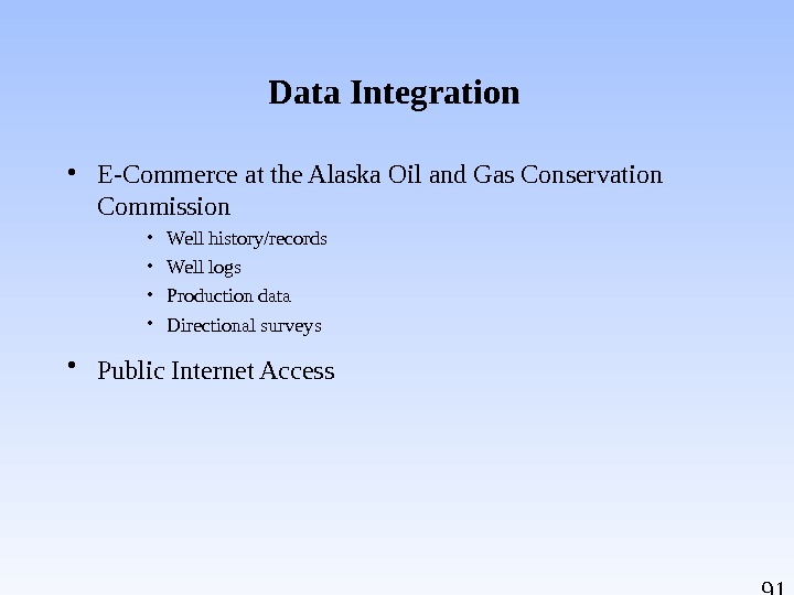
91 Data Integration • E-Commerce at the Alaska Oil and Gas Conservation Commission • Well history/records • Well logs • Production data • Directional surveys • Public Internet Access
92 jrc 04/05 Alaska Division of Geological and Geophysical Surveys 3354 College Road Fairbanks, Alaska 99709 (907) 451 -5000 http: //wwwdggs. dnr. state. ak. us/ • Among the Division’s missions is determination of the potential of Alaskan land for production of metals, minerals, fuels and geothermal resources • Major state-wide programs are mineral and energy resource appraisals and engineering geology investigations. • Energy resource appraisal program includes continuation of the North Alaska field program consortium and Alaska Peninsula field programs. • Numerous reports, most addressing hard-rock minerals and geohazards, are available on-line. • Geologic Materials Center (GMC) in Eagle River is the public depository for non-confidential well cuttings and cores, thin sections, outcrop samples and analytical reports. Contact curator John Reeder at (907) 696 -0079 or at john_reeder@dnr. state. ak. us for information.
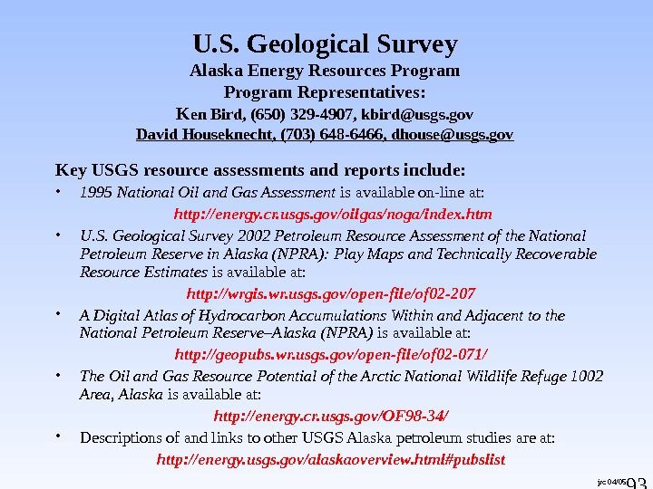
93 jrc 04/05 U. S. Geological Survey Alaska Energy Resources Program Representatives: K en Bird, (650) 329 -4907, kbird@usgs. gov David Houseknecht, (703) 648 -6466, dhouse@usgs. gov Key USGS resource assessments and reports include: • 1995 National Oil and Gas Assessment is available on-line at: http: //energy. cr. usgs. gov/oilgas/noga/index. htm • U. S. Geological Survey 2002 Petroleum Resource Assessment of the National Petroleum Reserve in Alaska (NPRA): Play Maps and Technically Recoverable Resource Estimates is available at: http: //wrgis. wr. usgs. gov/open-file/of 02 -207 • A Digital Atlas of Hydrocarbon Accumulations Within and Adjacent to the National Petroleum Reserve–Alaska (NPRA) is available at: http: //geopubs. wr. usgs. gov/open-file/of 02 -071/ • The Oil and Gas Resource Potential of the Arctic National Wildlife Refuge 1002 Area, Alaska is available at: http: //energy. cr. usgs. gov/OF 98 -34/ • Descriptions of and links to other USGS Alaska petroleum studies are at: http: //energy. usgs. gov/alaskaoverview. html#pubslist
94 jrc 12/03 U. S. Bureau of Land Management Branch of Energy Minerals 222 West 7 th Avenue, #13 Anchorage, AK 99513 -7599 (907) 271 -5960 http: //www. ak. blm. gov/ak 940/index 2. html • The Branch of Energy Minerals is responsible for the mineral leasing program and related functions, reservoir management, approval and inspection of drilling and production operations including oil and gas, geothermal, coal, and other energy minerals. • Links to National Petroleum Reserve-Alaska information are available at: http: //www. ak. blm. gov/ • The BLM, Native corporations and state resource management agencies share joint management responsibilities for several producing units in the Cook Inlet/Kenai Peninsula area.
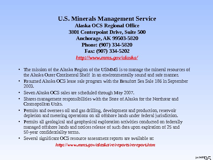
95 jrc 04/05 U. S. Minerals Management Service Alaska OCS Regional Office 3801 Centerpoint Drive, Suite 500 Anchorage, AK 99503 -5820 Phone: (907) 334 -5820 Fax: (907) 334 -5202 http: //www. mms. gov/alaska/ • The mission of the Alaska Region of the USMMS is to manage the mineral resources of the Alaska Outer Continental Shelf in an environmentally sound and safe manner. • Resumed Alaska OCS lease sale program with the Beaufort Sea Sale 186 in September 2003. • Seven Alaska OCS sales are scheduled through May 2007. • Shares management responsibilities with the State of Alaska for the Northstar and Cosmopolitan Units. • Permits and oversees oil and gas drilling, development and production, reservoir depletion and metering operations on all offshore lands under federal jurisdiction. • Permits all geological and geophysical exploration activities conducted on federally managed offshore lands and notices release of such data upon expiration of 25 and 50 -year confidentiality terms. • Several significant OCS resource assessment reports are available at: http: //www. mms. gov/alaska/re/reports/rereport. htm
96 jrc 04/05 Alaska Oil and Gas Association 121 W. Fireweed, Suite 207 Anchorage, AK 99503 (907) 272 -1481 http: //www. aoga. org • AOGA is a trade association established for the purpose of fostering the long-term viability of the oil and gas industry in Alaska by providing a forum for communication and cooperation with its members, with the public and with local, state and federal governments. • AOGA’s members are companies which represent the majority of oil and gas exploration, production, refining, transportation and marketing activities in Alaska. • A January 2001 report entitled The Economic Impact of the Oil and Gas Industry on Alaska is available on the website and is the first statewide study that accurately captures oil and gas industry employment and spending impacts.
jrc 04/05 Geophysical Contractors Presently Active in Alaska Fairweather Geophysical/Veritas DGC 715 L Street Anchorage, AK 99501 (907) 258 -3446 PGS Onshore, Inc. 341 West Tudor Road, Suite 206 Anchorage, AK 99503 (907) 569 —
98 jrc 04/05 Exploration Consultants Petrotechnical Resources of Alaska (PRA) 3601 C Street, Suite 1378 Anchorage, AK 99503 (907) 272 -1232 David M. Hite, Ph. D. Consulting Petroleum Geologist 2250 Woodworth Circle Anchorage, AK 99517 (907) 258 -9059 Arlen Ehm Geological Consultant 2420 Foxhall Drive Anchorage, AK 99504 (907) 333 -8880 Arctic Geoscience, Inc. 12100 Industry Way Anchorage, AK 99515 (907) 522 -4300 Terrasat 1413 West 31 st Avenue Anchorage, AK 99503 (907) 344 -9370 ASRC Energy Services E&P Technology 3900 C Street, Suite 702 Anchorage, AK 99503 (907) 339 —
99 jrc 04/05 Mapping Services MAPMAKERS ALASKA 259 South Alaska Street Palmer, AK 99645 (907) 745 -3398 Excellent source for maps depicting land ownership, leasehold information, unit boundaries, key exploration well locations and related information.
10 0 jrc 04/05 Charter for Development of the Alaskan North Slope • Proposed by BP and ARCO as a condition of merger and entered into with the State of Alaska on December 2, 1999. • Intended to promote competition, diversity, corporate responsibility and renewed and expanded exploration, development and production of Alaskan North Slope (ANS) oil and gas. • Addresses sale of ANS reserves and properties; marketing and sale of proprietary seismic and well data; facilities access; divestiture of TAPS and feeder line capacity to those buying production; sale of excessive tankerage; commitment to environmental requirements and charitable causes throughout the state; commitment to Alaska hire and Native recruitment. • Complete text of the Charter is available on the Division’s website at: http: //www. gov. state. ak. us/bparco/Final. Charter 1202. html • ARCO and BP seismic data are being brokered by Western. Geco, Houston, TX.
10 1 Independents in Alaska Venture Capital Group, LLC Alliance Energy, LLC Anadarko Petroleum Corporation Andex Resources, LLC Armstrong Alaska, Inc Aurora Gas, LLC BBI, Inc. Burlington Resources Alaska, Inc. Cassandra Energy Corporation Devon Energy Production Company En. Cana Oil and Gas (USA), Inc. Evergreen Resources Alaska, Inc. Forest Oil Corporation Gas-Pro Alaska, LLC Lapp Resources, Inc. Murphy Exploration (Alaska), Inc Northstar Energy Group, Inc. Pioneer Natural Resources Alaska, Inc. Pioneer Oil Company Prodigy Alaska, LLC Rutter & Wilbanks Corp. Trading Bay Oil and Gas, LLC Ultrastar Exploration, LLC Union Oil Company of California Winstar Petroleum, LLC XTO Energy, Inc. pb 05/