75841eb438c74a3a86e1cdae83cc46ce.ppt
- Количество слайдов: 18
 Ocean Model Impact Tiger Team (OMITT) Chair and co-chair: H. -S. Kim, G. Halliwell Team: P. Black, N. Bond, S. Chen, J. Cione, M. Cronin, J. Dong, I. Ginis, B. Jaimes, S. Jayne, B. Liu, L. Miller, E. Sanabia, N. Shay, V. Tallapragada, B. Thomas, E. Uhlhorn, and L. Zhu Institutions: EMC, NESDIS, DTC, HRD/AOML, Pho. D/AOML, PMEL, USNA, Navy, URI, UMiami, JISAO/Uwashington, and WHOI Wednesday November 18, 2015 HFIP Annual Meeting Kim et al. 1
 Overview 1. Group and Tasks – Update 2. Storms Proposed to Study - Update 3. Activity Summary 4. Ocean Impact Study – Preliminary Results 5. Summary 6. Future Plans Kim et al. 2
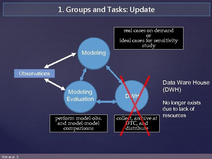 1. Groups and Tasks: Update real cases on demand or ideal cases for sensitivity study Modeling Observations Modeling Evaluation perform model-obs. and model-model comparisons Kim et al. 3 DWH collect, archive at DTC, and distribute Data Ware House (DWH) No longer exists due to lack of resources
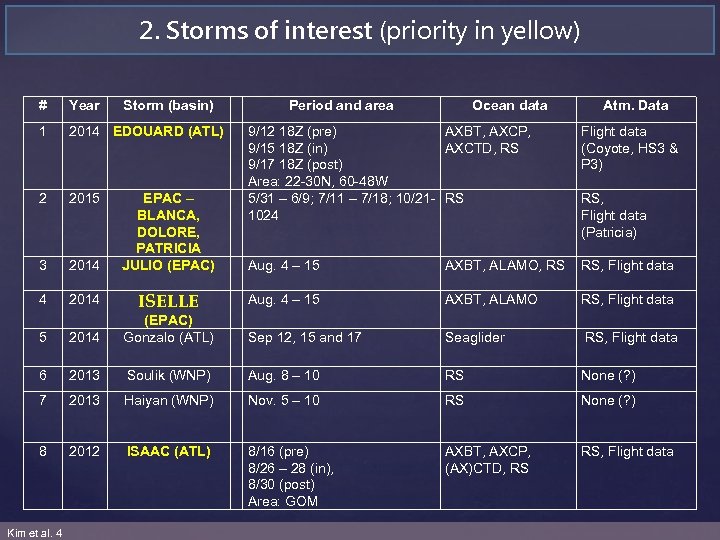 2. Storms of interest (priority in yellow) # Year Storm (basin) 1 2014 EDOUARD (ATL) 2 2015 3 2014 EPAC – BLANCA, DOLORE, PATRICIA JULIO (EPAC) 4 2014 ISELLE 5 Period and area Ocean data Atm. Data 9/12 18 Z (pre) AXBT, AXCP, 9/15 18 Z (in) AXCTD, RS 9/17 18 Z (post) Area: 22 -30 N, 60 -48 W 5/31 – 6/9; 7/11 – 7/18; 10/21 - RS 1024 Flight data (Coyote, HS 3 & P 3) Aug. 4 – 15 AXBT, ALAMO, RS RS, Flight data Aug. 4 – 15 AXBT, ALAMO RS, Flight data 2014 (EPAC) Gonzalo (ATL) Sep 12, 15 and 17 Seaglider RS, Flight data 6 2013 Soulik (WNP) Aug. 8 – 10 RS None (? ) 7 2013 Haiyan (WNP) Nov. 5 – 10 RS None (? ) 8 2012 ISAAC (ATL) 8/16 (pre) 8/26 – 28 (in), 8/30 (post) Area: GOM AXBT, AXCP, (AX)CTD, RS RS, Flight data Kim et al. 4 RS, Flight data (Patricia)
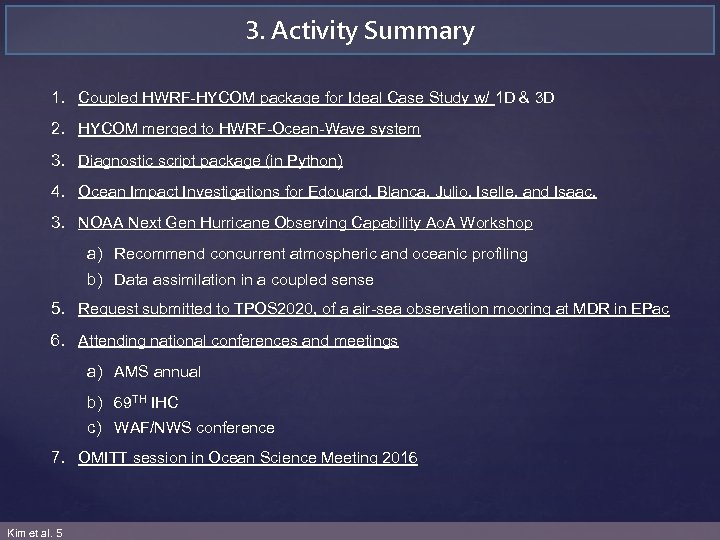 3. Activity Summary 1. Coupled HWRF-HYCOM package for Ideal Case Study w/ 1 D & 3 D 2. HYCOM merged to HWRF-Ocean-Wave system 3. Diagnostic script package (in Python) 4. Ocean Impact Investigations for Edouard, Blanca, Julio, Iselle, and Isaac. 3. NOAA Next Gen Hurricane Observing Capability Ao. A Workshop a) Recommend concurrent atmospheric and oceanic profiling b) Data assimilation in a coupled sense 5. Request submitted to TPOS 2020, of a air-sea observation mooring at MDR in EPac 6. Attending national conferences and meetings a) AMS annual b) 69 TH IHC c) WAF/NWS conference 7. OMITT session in Ocean Science Meeting 2016 Kim et al. 5
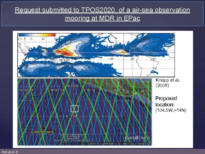 Request submitted to TPOS 2020, of a air-sea observation mooring at MDR in EPac Fwd: Questionnaire about Tropical Pacific Observing System Planetary Boundary Layer Observations from: to: cc: date: subject: Meghan Cronin - NOAA Federal
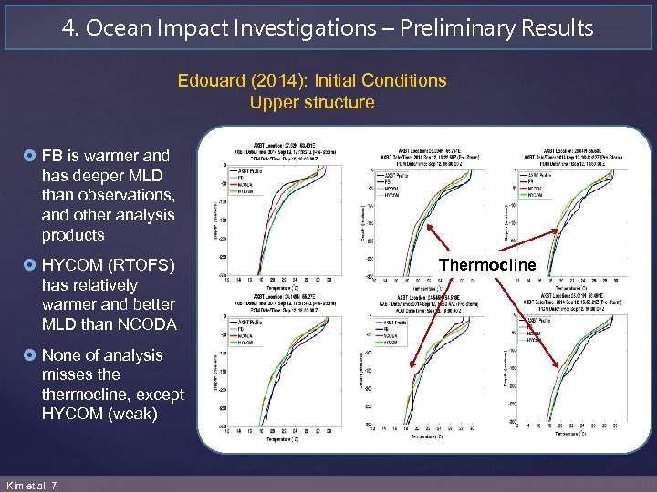 4. Ocean Impact Investigations – Preliminary Results Edouard (2014): Initial Conditions Upper structure £ FB is warmer and has deeper MLD than observations, and other analysis products £ HYCOM (RTOFS) has relatively warmer and better MLD than NCODA £ None of analysis misses thermocline, except HYCOM (weak) Kim et al. 7 Thermocline
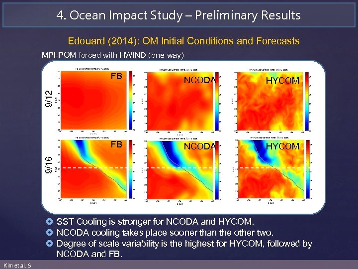 4. Ocean Impact Study – Preliminary Results Edouard (2014): OM Initial Conditions and Forecasts MPI-POM forced with HWIND (one-way) NCODA HYCOM FB NCODA HYCOM 9/16 9/12 FB £ SST Cooling is stronger for NCODA and HYCOM. £ NCODA cooling takes place sooner than the other two. £ Degree of scale variability is the highest for HYCOM, followed by NCODA and FB. Kim et al. 8
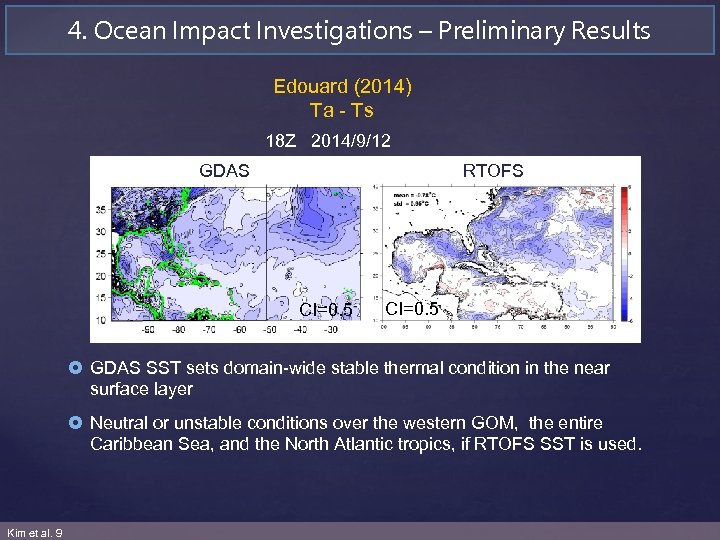 4. Ocean Impact Investigations – Preliminary Results Edouard (2014) Ta - Ts 18 Z 2014/9/12 GDAS RTOFS CI=0. 5 £ GDAS SST sets domain-wide stable thermal condition in the near surface layer £ Neutral or unstable conditions over the western GOM, the entire Caribbean Sea, and the North Atlantic tropics, if RTOFS SST is used. Kim et al. 9
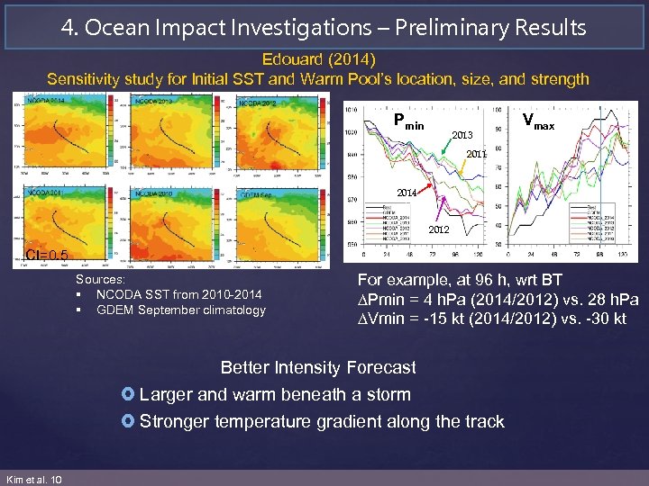 4. Ocean Impact Investigations – Preliminary Results Edouard (2014) Sensitivity study for Initial SST and Warm Pool’s location, size, and strength Pmin 2 0 1 3 2013 Vmax 2011 20 2014 14 20 2012 12 CI=0. 5 Sources: § NCODA SST from 2010 -2014 § GDEM September climatology For example, at 96 h, wrt BT Pmin = 4 h. Pa (2014/2012) vs. 28 h. Pa Vmin = -15 kt (2014/2012) vs. -30 kt Better Intensity Forecast £ Larger and warm beneath a storm £ Stronger temperature gradient along the track Kim et al. 10
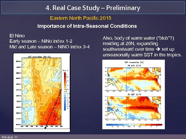 4. Real Case Study – Preliminary Eastern North Pacific 2015 Importance of Intra-Seasonal Conditions El Nino Early season – Ni. No index 1 -2 Mid and Late season – Ni. NO index 3 -4 Kim et al. 11 Also, body of warm water (“blob”? ) residing at 20 N, expanding southwestward over time set up unseasonally warm SST in the tropics.
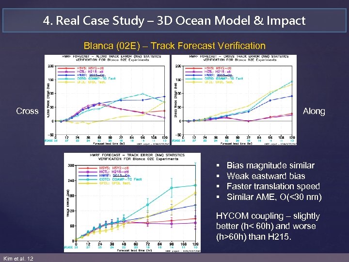 4. Real Case Study – 3 D Ocean Model & Impact Blanca (02 E) – Track Forecast Verification Cross Along § § Bias magnitude similar Weak eastward bias Faster translation speed Similar AME, O(<30 nm) HYCOM coupling – slightly better (h< 60 h) and worse (h>60 h) than H 215. Kim et al. 12
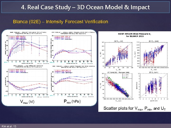 4. Real Case Study – 3 D Ocean Model & Impact Blanca (02 E) – Intensity Forecast Verification £ All shows negative Vmax bias, but HYCOM coupling shows better forecast skill by O(<15 kt). £ Vmax forecast AME for HYCOM coupling is better by O(<6 kt). £ Smaller Pmin error for HYCOM at hours < 48, but relatively large at 72 h. Vmax (kt) Kim et al. 13 Pmin (h. Pa) £ Smaller Pmin bias for HYCOM coupling over all, whereas positive bias for POM coupling.
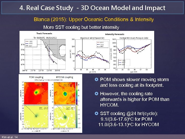 4. Real Case Study - 3 D Ocean Model and Impact Blanca (2015): Upper Oceanic Conditions & Intensity More SST cooling but better intensity £ POM shows slower moving storm and less cooling at its footprint. £ However, the cooling rate afterwards is higher for POM than HYCOM. £ SST cooling @24 hr/(cycle): 9. 1/(3. 6 -17. 6)o. C for POM 11. 0/(3. 6 -13. 1)o. C for HYCOM Kim et al. 14
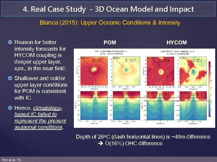 4. Real Case Study - 3 D Ocean Model and Impact Blanca (2015): Upper Oceanic Conditions & Intensity £ Reason for better intensity forecasts for HYCOM coupling is deeper upper layer, eps. , in the near field. POM HYCOM £ Shallower and colder upper layer conditions for POM is consistent with IC. £ Hence, climatologybased IC failed to represent the present seasonal conditions. Depth of 26 o. C (dash horizontal lines) is ~40 m difference O(16%) OHC difference Kim et al. 15
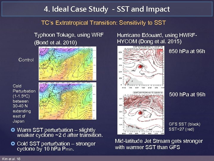 4. Ideal Case Study - SST and Impact TC’s Extratropical Transition: Sensitivity to SST Typhoon Tokage, using WRF (Bond et al. 2010) Hurricane Edouard, using HWRFHYCOM (Dong et al. 2015) 850 h. Pa at 96 h Control Cold Perturbation (1 -1. 5 o. C) between 30 -40 N extending east of Japan £ Warm SST perturbation – slightly weaker cyclone ~2 d after transition. £ Cold SST perturbation – stronger cyclone by 10 h. Pa Pmin. Kim et al. 16 500 h. Pa at 96 h GFS SST (black) SST=27 (red) Mid-latitude Jet Stream gets stronger with warmer SST than GFS
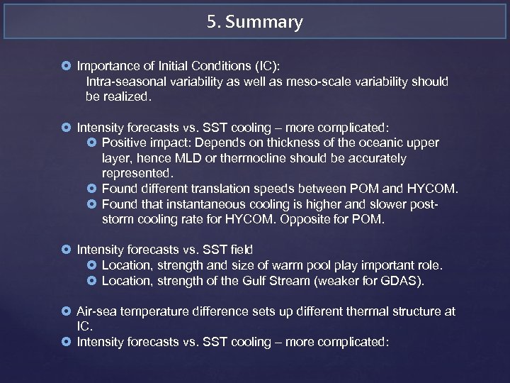 5. Summary £ Importance of Initial Conditions (IC): Intra-seasonal variability as well as meso-scale variability should be realized. £ Intensity forecasts vs. SST cooling – more complicated: £ Positive impact: Depends on thickness of the oceanic upper layer, hence MLD or thermocline should be accurately represented. £ Found different translation speeds between POM and HYCOM. £ Found that instantaneous cooling is higher and slower poststorm cooling rate for HYCOM. Opposite for POM. £ Intensity forecasts vs. SST field £ Location, strength and size of warm pool play important role. £ Location, strength of the Gulf Stream (weaker for GDAS). £ Air-sea temperature difference sets up different thermal structure at IC. £ Intensity forecasts vs. SST cooling – more complicated:
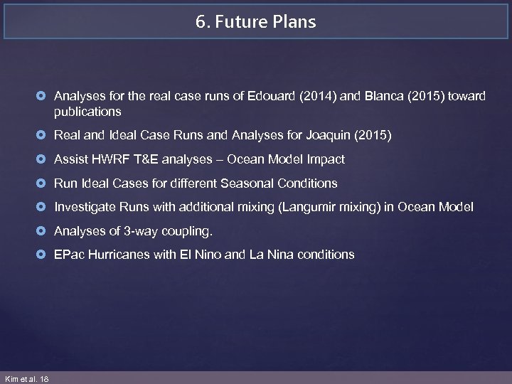 6. Future Plans £ Analyses for the real case runs of Edouard (2014) and Blanca (2015) toward publications £ Real and Ideal Case Runs and Analyses for Joaquin (2015) £ Assist HWRF T&E analyses – Ocean Model Impact £ Run Ideal Cases for different Seasonal Conditions £ Investigate Runs with additional mixing (Langumir mixing) in Ocean Model £ Analyses of 3 -way coupling. £ EPac Hurricanes with El Nino and La Nina conditions Kim et al. 18


