81e22f72ad80015c0d60827473eb370f.ppt
- Количество слайдов: 25
 Nowcasting Convective Storms for Aviation in NCAR/RAL Convective Weather Group Cai Huaqing National Center for Atmospheric Research Boulder, CO, USA
 Outline • Very-short term storm forecast (0 -2 hr) ---NCAR Auto-Nowcaster • Short-term storm forecast (0 -8 hr) ---- FAA Co. SPA (Consolidated Storm Prediction for Aviation) • Very-short term storm forecast over the ocean (Oceanic Convective Diagnosis and Nowcsting
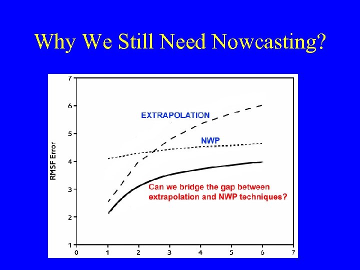 Why We Still Need Nowcasting?
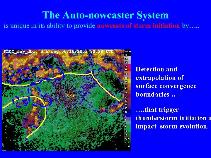 The Auto-nowcaster System is unique in its ability to provide nowcasts of storm initiation by…. . Detection and extrapolation of surface convergence boundaries …. that trigger thunderstorm initiation a impact storm evolution.
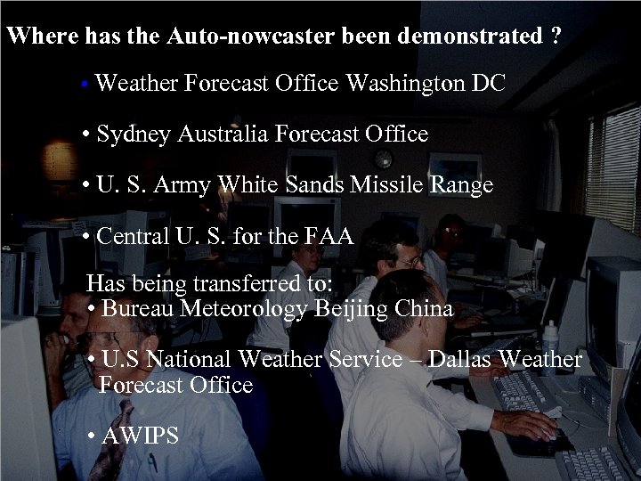 Where has the Auto-nowcaster been demonstrated ? • Weather Forecast Office Washington DC • Sydney Australia Forecast Office • U. S. Army White Sands Missile Range • Central U. S. for the FAA Has being transferred to: • Bureau Meteorology Beijing China • U. S National Weather Service – Dallas Weather Forecast Office • AWIPS
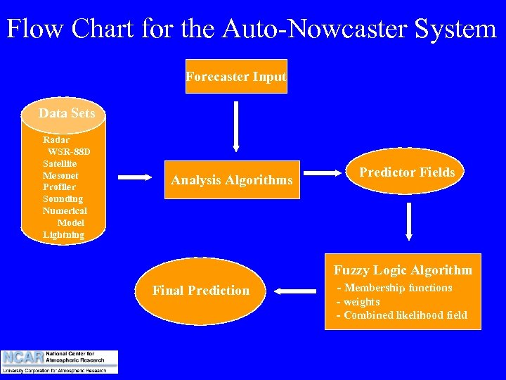 Flow Chart for the Auto-Nowcaster System Forecaster Input Data Sets Radar WSR-88 D Satellite Mesonet Profiler Sounding Numerical Model Lightning Analysis Algorithms Predictor Fields Fuzzy Logic Algorithm Final Prediction - Membership functions - weights - Combined likelihood field
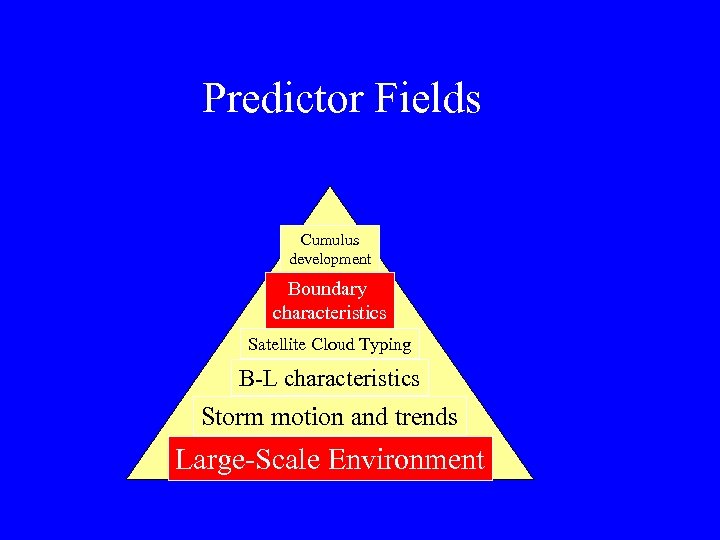 Predictor Fields Cumulus development Boundary characteristics Satellite Cloud Typing B-L characteristics Storm motion and trends Large-Scale Environment
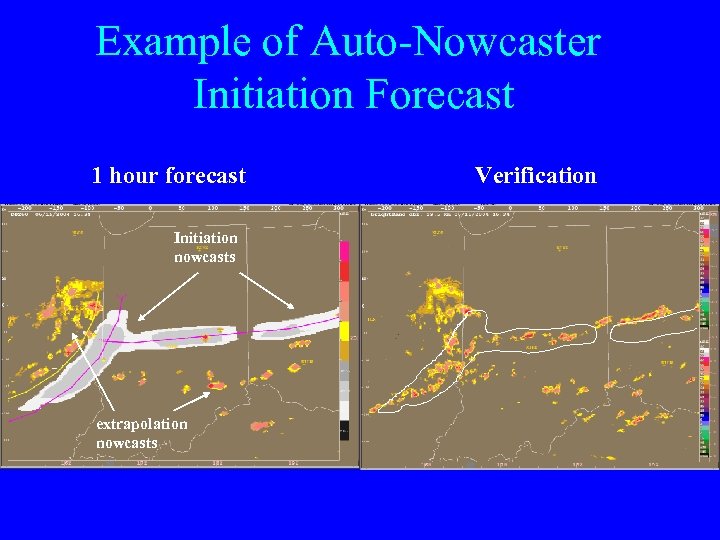 Example of Auto-Nowcaster Initiation Forecast 1 hour forecast Initiation nowcasts extrapolation nowcasts Verification
 Co. SPA • 0 -8 hr blended forecasting system developed by MIT/LL, NOAA GSD and NCAR. • It provides VIL and echo top forecasts for Federal Aviation Administration. • It uses Hrrr (High resolution rapid refresh) model developed by NOAA GSD. • NCAR is responsible for blending the extrapolated forecast provided by MIT/LL and Hrrr forecasts produced by NOAA GSD.
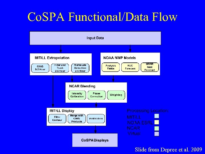 Co. SPA Functional/Data Flow Slide from Depree et al. 2009
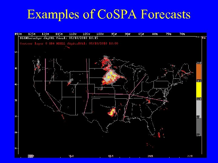 Examples of Co. SPA Forecasts
 Forecasting Convection Over the Ocean • Why we care storms over the ocean? • Diagnosis of oceanic convection • Nowcasting of oceanic convection • Uplink weather information into the cockpit
 Motivation : Air France 447 Longwave IR (0145 UTC) Convection Diagnosis Oceanic (CDO) (approx. ) Last 1 June 0145 (0145 UTCACARS 2009) UTC Air France 447 message, 0214 UTC + (approx. ) Last verbal contact, 0133 UTC Cloud Top Height (0145 UTC) (approx. ) Last ACARS message, 0214 UTC + (approx. ) Last verbal contact, 0133 UTC • The wide-area view provided by real-time experimental Global Convection/Turbulence uplinks may have improved pilot situational awareness
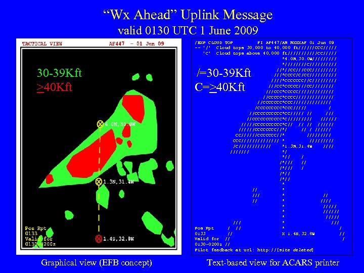 “Wx Ahead” Uplink Message valid 0130 UTC 1 June 2009 30 -39 Kft >40 Kft Graphical view (EFB concept) /EXP CLOUD TOP FI AF 447/AN NXXXAF 01 Jun 09 -- '/' Cloud tops 30, 000 to 40, 000 ft//////CCC///// 'C' Cloud tops above 40, 000 ft//////CC///// *4. 0 N, 30. 0 W///// *////C///// //*//CC///CCC///// ///*CCCC/C/CC/////*CCCCCCC//C///// ///CC*CCCCC//////// ///CCC*CCCCC/////// //CCCCC*CCCC/////// //CCCCCCC*CCC/////// /CCCCC*CCC///// / //CCCCC*CC///// // //CCCCCC*C/////CCCCC*C// //////CCCC//*/ ////// CC//////CCCCCCC//* ///// CCC/////// * ///// /C////// *1. 3 N, 31. 4 W /////// */ *// / /*/// / /*// * /// * ///// * ///// /// * /// Pos Rpt / // * / 0133 // X 1. 4 S, 32. 8 W // Valid for // / 0130 -0200 z // Pilot feedback at url: http: //[site deleted] /=30 -39 Kft C=>40 Kft Text-based view for ACARS printer
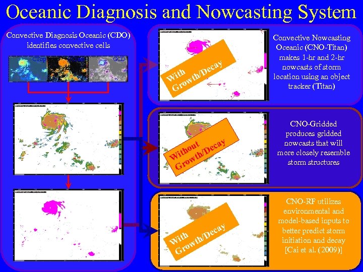 Oceanic Diagnosis and Nowcasting System Convective Diagnosis Oceanic (CDO) identifies convective cells CTop CClass GCD cay e h/D CNOTitan Nowcast Convective Nowcasting Oceanic (CNO-Titan) makes 1 -hr and 2 -hr nowcasts of storm location using an object tracker (Titan) CNOGridded Nowcast CNO-Gridded produces gridded nowcasts that will more closely resemble storm structures CNO-RF Random Forest Nowcast CNO-RF utilizes environmental and model-based inputs to better predict storm initiation and decay [Cai et al. (2009)] ith t W ow Gr CDO Interest ut ecay o ith th/D W ow Gr CDO Binary Product ith th W ow Gr cay /De
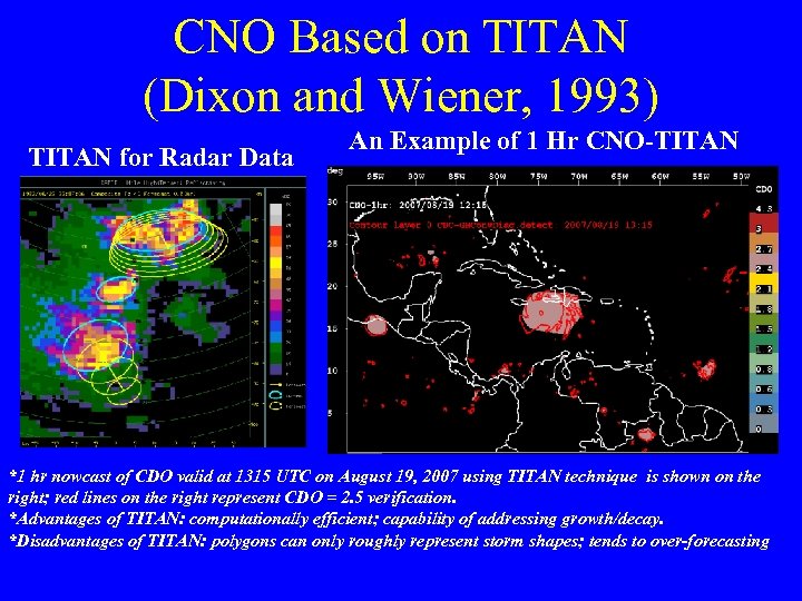 CNO Based on TITAN (Dixon and Wiener, 1993) TITAN for Radar Data An Example of 1 Hr CNO-TITAN *1 hr nowcast of CDO valid at 1315 UTC on August 19, 2007 using TITAN technique is shown on the right; red lines on the right represent CDO = 2. 5 verification. *Advantages of TITAN: computationally efficient; capability of addressing growth/decay. *Disadvantages of TITAN: polygons can only roughly represent storm shapes; tends to over-forecasting
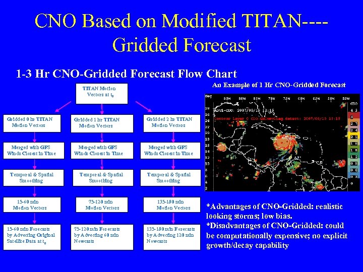 CNO Based on Modified TITAN---Gridded Forecast 1 -3 Hr CNO-Gridded Forecast Flow Chart An Example of 1 Hr CNO-Gridded Forecast TITAN Motion Vectors at t 0 Gridded 0 hr TITAN Motion Vectors Gridded 1 hr TITAN Motion Vectors Merged with GFS Winds Closest in Time Temporal & Spatial Smoothing 15 -60 min Motion Vectors 15 -60 min Forecasts by Advecting Original Satellite Data at t 0 Temporal & Spatial Smoothing 75 -120 min Motion Vectors 75 -120 min Forecasts by Advecting 60 min Nowcasts Gridded 2 hr TITAN Motion Vectors Merged with GFS Winds Closest in Time Temporal & Spatial Smoothing 135 -180 min Motion Vectors 135 -180 min Forecasts by Advecting 120 min Nowcasts *Advantages of CNO-Gridded: realistic looking storms; low bias. *Disadvantages of CNO-Gridded: could be computationally expensive; no explicit growth/decay capability
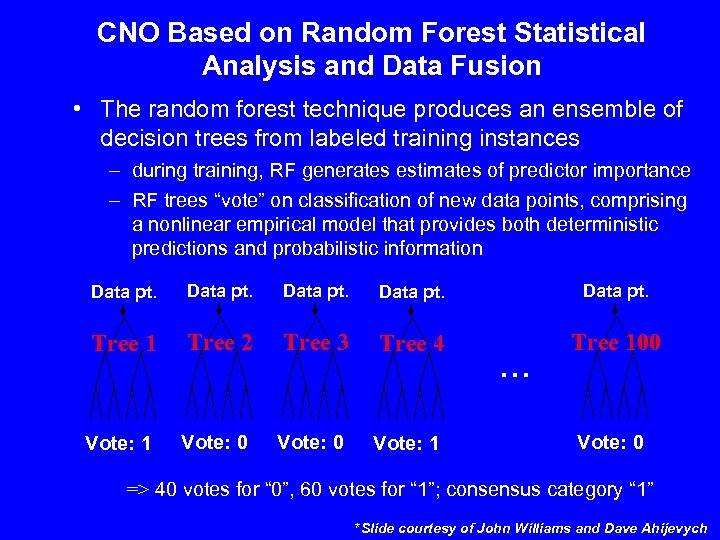 CNO Based on Random Forest Statistical Analysis and Data Fusion • The random forest technique produces an ensemble of decision trees from labeled training instances – during training, RF generates estimates of predictor importance – RF trees “vote” on classification of new data points, comprising a nonlinear empirical model that provides both deterministic predictions and probabilistic information Data pt. Tree 1 Tree 2 Tree 3 Tree 4 Tree 100 Vote: 1 Vote: 0 Vote: 1 … Vote: 0 => 40 votes for “ 0”, 60 votes for “ 1”; consensus category “ 1” *Slide courtesy of John Williams and Dave Ahijevych
 CNO-RF B Hurricane Dean A C D CNO-TITAN B A CNO Hurricane Dean C D An Example of CNORF Forecast Compared with CNO-TITAN ( 1 hr) *1 hr forecasts valid at 1315 UTC on August 19, 2007 for both techniques; Red lines represent CDO = 2. 5 verification *Advantages of random forest technique: more realistic looking storms; taking into account of storm environment to address storm growth/decay.
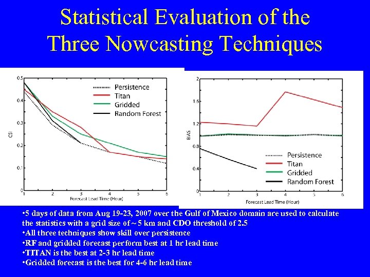 Statistical Evaluation of the Three Nowcasting Techniques CSI BIAS • 5 days of data from Aug 19 -23, 2007 over the Gulf of Mexico domain are used to calculate the statistics with a grid size of ~ 5 km and CDO threshold of 2. 5 • All three techniques show skill over persistence • RF and gridded forecast perform best at 1 hr lead time • TITAN is the best at 2 -3 hr lead time • Gridded forecast is the best for 4 -6 hr lead time
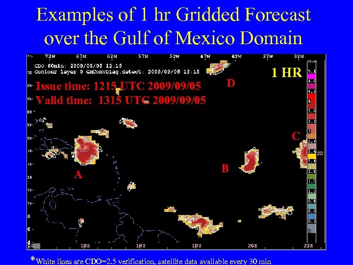 Examples of 1 hr Gridded Forecast over the Gulf of Mexico Domain Issue time: 1215 UTC 2009/09/05 Valid time: 1315 UTC 2009/09/05 D 1 HR C A B *White lines are CDO=2. 5 verification, satellite data available every 30 min
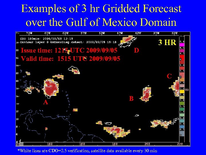 Examples of 3 hr Gridded Forecast over the Gulf of Mexico Domain Issue time: 1215 UTC 2009/09/05 Valid time: 1515 UTC 2009/09/05 D 3 HR C A B *White lines are CDO=2. 5 verification, satellite data available every 30 min
 Examples of 6 hr Gridded Forecast over the Gulf of Mexico Domain Issue time: 1215 UTC 2009/09/05 Valid time: 1815 UTC 2009/09/05 D 6 HR C A B *White lines are CDO=2. 5 verification, satellite data available every 30 min
 Summary Statistics of CNO-Gridded Forecasts The black squares are statistics from Aug 19 -22, 2007 What are the GFS model scores for oceanic convection? ? ? • 30 days of data from Sep 1 -30, 2009 over the Gulf of Mexico domain are used to calculate the statistics with a grid size of ~ 5 km and CDO threshold of 2. 5 • The results showed here could serve as benchmark performance of extrapolation-based nowcasting techniques for oceanic convection • Similar verification for model forecasts need to be done so that a comparison of convective forecasting skills between model and extrapolation can be obtained
 Summary • Multiple short-term convective forecasting products, both over land over ocean, are being researched, developed and tested at NCAR/RAL for various agencies such as FAA, NOAA and NASA. • Potential collaborations in the nowcasting areas would be beneficial to all participants.


