3e6f2d526e68213a113209c4fe15538b.ppt
- Количество слайдов: 51


NOAA Small Boat Program Workshop Personal EPIRBs Oct 10, 2003 – Seattle, WA S A R S A T
 Ø Mission Control Centers")
Overview - SARSAT 101 Ø Beacons Ø Ground Stations (LUTs) Ø Mission Control Centers (MCCs) Ø Rescue Coordinations Centers (RCCs) Ø 121. 5 MHz Phaseout, Carriage Reqs, The Future Ø The Bottom Line - The Fast. Find Plus PEPIRB - Ok, Now What Do We Do With It? Ø Registration Ø Let’s Avoid Calling the Coasties… Ø Use of Direction Finders Ø Q&A

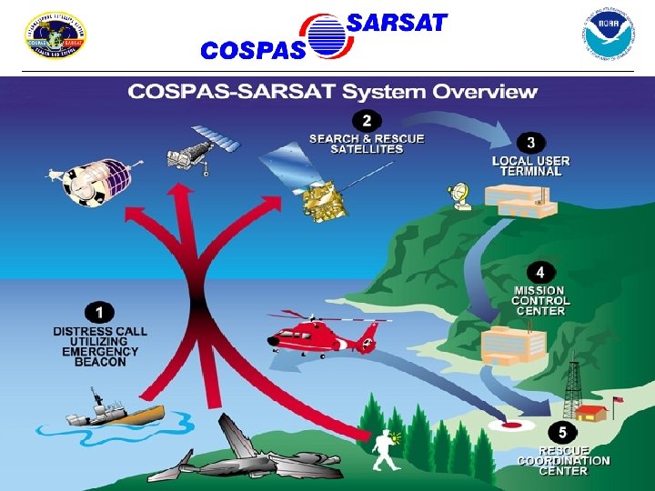
What is Cospas-Sarsat? ? ? COSPAS = Cosmicheskaya Systyema Poiska Aariynyich Sudov Which loosely translates into: “The Space System for the Search of Vessels in Distress” SARSAT = Search And Rescue Satellite Aided Tracking In short, Cospas-Sarsat takes the “search” out of Search & Rescue


Emergency Beacons • Two types: 121. 5/243 MHz and 406 MHz • Three applications: - Emergency Position Indication Radio Beacons (EPIRB) for Maritime Uses - Emergency Locator Transmitters (ELT) for Aviation Uses - Personal Locator Beacons (PLB) for Remote Area Recreational Uses - NOW AVAILABLE!!!

121. 5 MHz Beacons • Older technology • Not designed for satellite processing (no store & forward capability) • Analog signal only = no identification code • Does not have global coverage! • Low power ( < 1 watt) • Less rigid standards • Poor location accuracy = Usually no better than 12 miles • USMCC handles 250 -400 ‘hits’ per day. 99. 9% are false!! Only 1 in 8 alerts come from beacons. The rest are ATM machines, pizza ovens, and the University of Arkansas Scoreboard! High false alert rate makes first-alert launch unfeasible…

121. 5/243 MHz Coverage “Holes”

243 MHz Beacons • Similar to 121. 5 MHz beacons • Primarily used by the military • Many existing 121. 5 MHz also transmit on 243 MHz
")
406 MHz Beacons • Newer technology • Designed for satellite processing (store & forward) • Global coverage • Digital signal • Increased power (5 watt) • Unique Identification • Rigid specifications • More Accurate = 2 - 3 mile location accuracy. Even better with integral GPS units = 100 meter accuracy!
 Input • Improved location accuracy • Instantaneous detection AND location!")
Beacons with Navigation (GPS) Input • Improved location accuracy • Instantaneous detection AND location! 406 MHz with GPS 121. 5 MHz Search Time = Minimal Search Time = 2 - 3 hours Search Time = 12+ hours

 (8) Satellites")
2 Types of Satellites: • Low Earth Orbiting Search And Rescue (LEOSAR) (8) Satellites in Orbit: - COSPAS 4, 9, 10 - • Cospas-Sarsat Space Segment SARSAT 4, 6, 7, 8, 9 Geostationary Orbiting Search And Rescue (GEOSAR) (4) Satellites in Orbit: - GOES 8 (West) - GOES 10 (East) - INSAT 3 A - MSG

LEO Satellite 406 MHz beacon detections can be stored on board the satellite and re-broadcast later LUT 121. 5/243 MHz Beacon Detection of a 121. 5/243 MHz beacon requires mutual visibility between beacon, satellite and ground station (LUT) LEO Satellite LUT 406 MHz Beacon
 Operations")
Local Mode (‘Bent Pipe’) Operations
 Operations")
Global Mode (‘Store & Forward’) Operations
 • Track COSPAS and SARSAT satellites")
Cospas-Sarsat Ground Stations LEOSAR Local User Terminals (LEOLUT) • Track COSPAS and SARSAT satellites • Recover beacon signals • Perform error checking • Perform Doppler processing • Send alert to Mission Control Center

42 LEOLUT Locations Worldwide
 Texas Hawaii Alaska Florida")
United States LEOLUTs Guam California Maryland (Deployable LUT) Texas Hawaii Alaska Florida
 • Track GOES and INSAT satellites • Recover beacon")
GEOSAR Local User Terminals (GEOLUT) • Track GOES and INSAT satellites • Recover beacon signals • Perform error checking • Send alert to Mission Control Center

9 GEOLUT Locations Worldwide Combe Martin UK Trenton- Canada Toulouse- France Maspalomas- Spain Bangalore- India Brasilia- Brazil Santiago- Chile GOES-W (135°W) GOES-E (75°W) Eizeiza – Argentina MSG (0°) Wellington– New Zealand INSAT-3 A (95. 5°E)

 • Receive alerts from national LUTs and foreign MCCs. •")
Mission Control Centers (MCC) • Receive alerts from national LUTs and foreign MCCs. • Validate, match and merge alerts to improve location accuracy and determine the correct destination. • Query 406 MHz Registration Database and transmit registration info with distress alert. • Transmit alerts to Rescue Coordination Centers (RCCs) and SAR Points of Contact (SPOC) and filter redundant data. • All USMCC functions are handled automatically…no manual intervention. • 24 x 7 x 365 operational center
 – 24 Locations")
Mission Control Centers (MCC) – 24 Locations

The United States Mission Control Center Suitland, MD Activity ü Handle 250 -400 121. 5/243 alerts/day ü Register 50 new beacons/day ü Handle 15 -20 406 MHz alerts/day ü Update 60 beacon registrations/day ü Transmit 1200 messages/day ü Confirm 300 beacon registrations/week ü Schedule and ingest data from ü Enter 35 incident feedback reports/day 500 satellite passes/day


- Receive SARSAT Distress Alerts from the USMCC - Coordinate the Rescue Response U. S. Coast Guard U. S. Air Force * Responsible for all Maritime Alerts * * Responsible for all Inland Alerts *
 AKRCC ELMENDORF RCC")
North America Rescue Coordination Centers & their Areas of Responsibility (AOR’s) AKRCC ELMENDORF RCC CLEVELAND RCC TRENTON RCC JUNEAU RCC HONOLULU (CG / PACOM) RCC HALIFAX RCC VICTORIA RCC SEATTLE RCC BOSTON AFRCC LANGLEY RCC NORFOLK RCC ALAMEDA RCC MIAMI RCC NEW ORLEANS COLOR KEY: USCG RCC’s U. S. DOD RCC’s CANADIAN RCC’s RSC SAN JUAN

United States Cospas-Sarsat Program Administration Inland SAR Maritime SAR Research & Development System Operation Representative to Cospas-Sarsat Program
 National Environmental Satellite, Data, and Information")
Organizational Structure National Oceanic and Atmospheric Administration (NOAA) National Environmental Satellite, Data, and Information Service (NESDIS) Office of Satellite Data Processing and Distribution (OSDPD) Direct Services Division (DSD) SARSAT Program Office & the U. S. Mission Control Center (USMCC) Suitland Federal Center, Suitland MD

National Search And Rescue Committee DOC S Sa ARSA tel lite T Le Se ad, rvi (NO ce s AA ) SA ( Inland SAR Lead Se P SA NASA RL ead /Re US gs CG s n io lat gu A FA Re io ad cy R or uen f ns req io lat s & F es u eg litie ssu R ci I a F t’l Na ark DOI Research and Development (USAF & DPMO) DOD s ice rv ) Se ice rv R DHS

International Organization • Initially developed under interagency Memorandum of Agreement signed in 1979 • International Cospas-Sarsat Programme Agreement signed on July 1, 1988 among the governments of Canada, France, the former U. S. S. R and the United States • Association with Programme allows States to contribute towards the ground segment or participate in international Cospas-Sarsat meetings • Goals of Cospas-Sarsat are to support SAR objectives of ICAO and IMO. Therefore, C-S maintains a close partnership with these U. N. agencies and the ITU

International Maritime Organization UN specialized agency responsible for improving maritime safety (Mandates use of emergency beacons) International Civil Aviation Organization UN specialized agency responsible for aviation matters and improving civil aviation safety (Mandates use of 406 MHz beacons) International Telecommunications Union UN specialized agency responsible for coordinating global telecommunications (406 MHz beacon specifications)

35 Member Nations & 2 SAR Organizations Officially Participate in Cospas-Sarsat
 Germany Indonesia Korea (Rep. of) New")
Member Nations Algeria Brazil China (P. R. of) Germany Indonesia Korea (Rep. of) New Zealand Pakistan Saudi Arabia Spain Thailand Vietnam Argentina Canada Denmark Greece Italy Madagascar Nigeria Peru Singapore Sweden Tunisia USA Australia Chile France India Japan Netherlands (The) Norway Russia South Africa Switzerland United Kingdom Participating Organizations The International Telecommunication Development Corporation (ITDC) The Marine Department of Hong Kong, China
")
*** 121. 5/243 MHz PHASE-OUT DECISION *** International Cospas-Sarsat Council (in conjuction with IMO/ICAO) announces the Termination of 121. 5 MHz Satellite Alerting on 01 February 2009 at its 25 th General Session (October 2000)

*** 121. 5/243 MHz PHASE-OUT DECISION *** Again, here are the reasons why this decision was made: • Coverage – Global vs Local • False Alerts • Identification • Accuracy • Alerting So, what does this mean to you and that old 121. 5 MHz EPIRB of yours? ? ? . . .

…it becomes “illegal for use” on Jan 1 st, 2007!!! This is a new regulation under the recently issued FCC Title 47, Part 80 rules (August, 2003) Can no longer purchase a 121. 5 MHz EPIRB as of Feb 1 st, 2003 FCC/USCG 406 MHz Vessel Carriage Requirements • • All vessels 300 gross tons or greater (SOLAS) Vessels engaged in transporting 6 or more persons *** In the U. S. all Commerical Fishing Vessels *** • All vessels in Hawaiian waters operating beyond 1 nmi of shore shall carry a 406 MHz EPIRB or DSC-VHF Radio (State legislature passed law in May, 2003. Effective Jan 1 st, 2004)

The Future of Cospas-Sarsat… The Distress Alerting Satellite System n 406 MHz “bent-pipe” repeaters on future GPS satellites n Full compatibility with existing + future 406 MHz beacons n Continued global detection and location: – Greater than current Cospas-Sarsat accuracy n Alert data downlink will continue to be freely available internationally n Possible two-way return link GPS Satellite

The Bottom Line… 2002 COSPAS-SARSAT Rescues ü 1, 545 persons rescued in 365 SAR events worldwide - 1341 maritime rescues in 239 SAR events - 83 aviation rescues in 47 SAR events - 121 land rescues in 79 SAR events 2002 U. S. SARSAT Rescues ü 171 persons rescued in 69 SAR events nationwide Since 1982 over 15, 000 lives rescued via Cospas-Sarsat! Nearly 5, 000 in U. S. AOR’s alone! - 133 maritime rescues in 64 SAR events - 11 aviation rescues in 5 SAR events - 27 land rescues in 18 SAR events

The Bottom Line… Worldwide Distribution of C-S Aided Rescues in 2002
 General Specs • Only personal")
The Mc. Murdo/Pains-Wessex Fast. Find Plus Personal EPIRB (PEPIRB) General Specs • Only personal beacon currently on the market with integral GPS • 406 MHz transmitter (and all the advantages therein) • 121. 5 MHz homing frequency (important!) • Coded as an EPIRB and not a PLB (only USCG & NOAA) • Alert time to USMCC within 3 minutes • Positional accuracy to 100 feet (best case) • Positional updates every 20 minutes • User replaceable lanyard attachment
 General Specs • User replaceable")
The Mc. Murdo/Pains-Wessex Fast. Find Plus Personal EPIRB (PEPIRB) General Specs • User replaceable battery packs (Class 1 & Class 2) • 24 -hour battery at Class 1 or Class 2 temps • Temperatures: Storage: -67 F to + 158 F (Class 1) Operating: -40 F to + 131 F (Class 1) Storage: -22 F to + 158 F (Class 2) Operating: -4 F to + 131 F (Class 2) • Flotation: Category 1: Must float in water Category 2: Not required to float Note: Fast. Find Plus with Class 1 battery does not float!

Ok, Now what do we do with it? ? ? Register The PEPIRB… Some reasons why registration is important: • Required by law • Saves SAR resources • Allows us to know who is in possible distress • Allows SAR to contact you, your lab/ship/office/etc. Where To Register It? ? ? Online: www. beaconregistration. noaa. gov, or www. sarsat. noaa. gov By Phone: 1 -888 -212 -SAVE or 1 -301 -457 -5678 By Fax: 1 -301 -568 -8649

NOAA’s New Online Beacon Registration Database www. beaconregistration. noaa. gov
 Read the Manual")
Avoid Calling the Coasties… …know how to use your PEPIRB 1) Read the Manual & Get Familiar With Your PEPIRB 2) Conduct One Self-Test Before An Outing Or Once x Month 3) Replace the Battery ~5 Years 4) Avoid Placing Where It Can Be Damaged Which May Activate It

Avoid Calling the Coasties… …know WHEN to use your PEPIRB In Situations Of Grave & Imminent Danger Where No Other Means of Communication Exist How To Operate: • Pull the red tab • Antenna will automatically deploy • Push start button • Ensure PEPIRB has clear view of sky • Keep antenna & antenna well as dry as possible
 Shut It Off, Einstein!")
What to do if your PEPIRB is accidentally activated 1) Shut It Off, Einstein! (50 -second “oops” factor built-in) 2) Call the nearest Coast Guard Station and inform them of accidental activation. Give them your name, vessel name, time of activation (or best guess), etc. 3) Contact Mc. Murdo/Pains-Wessex to reset the PEPIRB and to replace the battery
 Used For Terrestrial Location Works with all Beacons due to 121.")
Direction Finders (DF’ers) Used For Terrestrial Location Works with all Beacons due to 121. 5 MHz homers Provides MOB capability Can be used with 121. 65 MHz training beacons Hand – Held Models ACR’s Vecta-2 Fix-Mount Models Becker, Mc. Murdo, etc
 & Diver Locating Devices for use with DF’ers Mc.")
Additional Man Over Board (MOB) & Diver Locating Devices for use with DF’ers Mc. Murdo Guardian Wristwatch 121. 5 MHz Only Depth to ~150 feet 8 hour battery Not detectable by sats Mc. Murdo PEPIRB Dive Canister Depth to ~500 feet ACR Dive. Res. Q 121. 5 MHz Only Depth to ~200 feet 24 hour battery Retractable antenna extends above water line

Any Questions? ? ? FOR MORE INFO… LT Dann Karlson U. S. NOAA Corps 1 -301 -457 -5678 x 114 Or 1 -888 -212 -7283 x 114 NOAA/SARSAT E/SP 3, FB 4, Room 3320 5200 Auth Road Suitland, MD 20746 Fax: 1 -301 -568 -8649 Daniel. Karlson@noaa. gov Visit Our Website: www. sarsat. noaa. gov
3e6f2d526e68213a113209c4fe15538b.ppt