6d2868f040fb1307b2c0c85db2f94482.ppt
- Количество слайдов: 37
 NESDIS Report on NOAA GOES and POES Status NAEDEX Meeting #22 December 9 -11, 2009 ECMWF Reading, U. K. John Paquette NOAA/NESDIS/OSDPD
 Agenda • GOES Status and Schedule for 2009/2010 • GOES-10 Decommissioning • GOES-12 to -13 Transition and Validation • GOES-14 PLT and User Testing • POES Status and Priorities Schedule • NPP Status • GOES-R Update • Non-NOAA Significant Updates • New Products • Upcoming Products
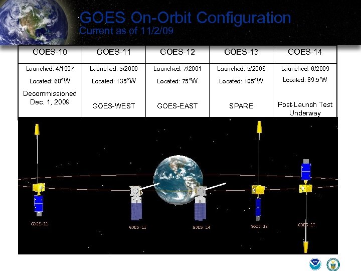 GOES On-Orbit Configuration Current as of 11/2/09 GOES-10 GOES-11 GOES-12 GOES-13 GOES-14 Launched: 4/1997 Launched: 5/2000 Launched: 7/2001 Launched: 5/2006 Launched: 6/2009 Located: 60°W Located: 135°W Located: 75°W Located: 105°W Located: 89. 5°W GOES-WEST GOES-EAST SPARE Post-Launch Test Underway Decommissioned Dec. 1, 2009
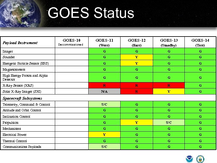 GOES Status Payload Instrument GOES-10 Imager GOES -11 GOES -12 GOES-13 GOES-14 (West) (East) (Standby) (Test) G Decommissioned G G G Sounder R G Y G G G Energetic Particle Sensor (EPS) Y G G Magnetometers G G G High Energy Proton and Alpha Detector G G G X-Ray Sensor (XRS) G R R R G N/A R Y G Telemetry, Command & Control G S/C G G G Attitude and Orbit Control G G G Inclination Control R G G Propulsion G G Y S/C G G G G Electrical Power G Y G G G Thermal Control G G G S/C G G G Solar X -Ray Imager (SXI) Spacecraft Subsystems Mechanisms Communications Payloads
 South America Coverage NOAA/NESDIS operating GOES-10 at 60 degrees West since December 2006. ü ü Provides continuous GOES coverage of South America during GOES EAST rapid scan operations. Positive impact to South American severe storm and flash flood forecast and warnings. GOES-10 at end of fuel life ü Decommissioned and de-orbited on December 1, 2009 NOAA has received requests to continue South American support through multiple international organizations NESDIS recommendation to utilize GOES-12 for South America coverage by June 2010 ü ü Can provide dedicated South America coverage in time for the North Atlantic hurricane season GOES-12 east-west fuel available for 3 years of operation þ No fuel remaining for inclination control
 GOES Status and Schedule for 2009/2010 Ø GOES-10 (60 W) was decommissioned on 12/1/09 at 1230 UTC due to lack of fuel Ø GOES-13 to replace GOES-12 in April 2010 ü Transition plan similar to GOES-8 to -12 transition ü GOES-13 imaging while drifting to 75° W ü GOES-East switch to GOES-13 when 13 is within 6° of GOES-12 (4/14) þ GOES-13 GVAR through GOES-12 until 4/26 ü GOES-12 drift to 60° W for South America þ GOES-12 South America coverage by June 2010
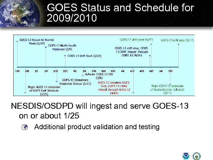 GOES Status and Schedule for 2009/2010 NESDIS/OSDPD will ingest and serve GOES-13 on or about 1/25 ü Additional product validation and testing
 GOES-East Detailed Transition 1/19 GOES-13 Return to Normal Mode Imager, Sounder, SEM activated SXI remains off 1/21 Image Navigation Start-up (4 days) 1/25 Begin GOES-13 execution of GOES East Schedule 2/9 Perform GOES-13 Annual inclination maneuver 2/17 Conduct GOES-13 Operations Readiness Review 2/23 Start GOES-13 Eastward Drift from 105°W to 75°W 3/8 Near 99°W; Activate GOES-13 SXI 4/14 Near 81°W; GOES-13 becomes GOES-East Stop GOES-12 GVAR GOES-13 GVAR relayed through GOES-12 Users do not re-point antenna 4/26 Stop GOES-13 Drift at 75°W GOES-13 GVAR relayed through GOES-13 Switch ancillary COMM services from GOES-12 to GOES-13
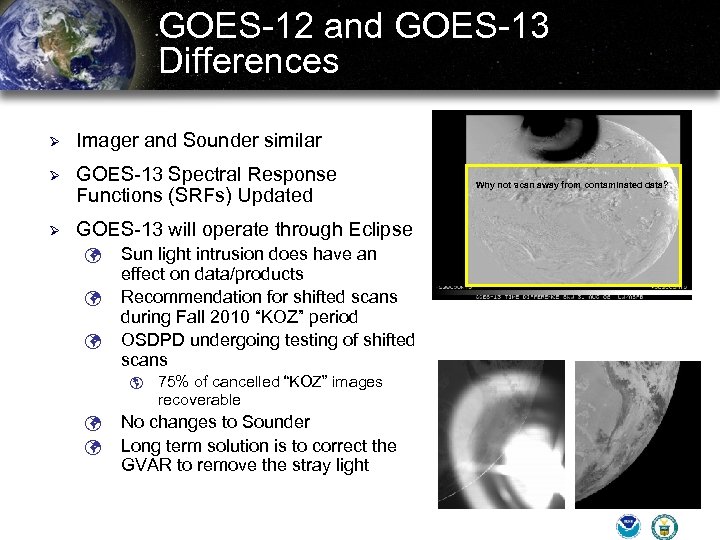 GOES-12 and GOES-13 Differences Ø Imager and Sounder similar Ø GOES-13 Spectral Response Functions (SRFs) Updated Ø GOES-13 will operate through Eclipse ü ü ü Sun light intrusion does have an effect on data/products Recommendation for shifted scans during Fall 2010 “KOZ” period OSDPD undergoing testing of shifted scans þ ü ü 75% of cancelled “KOZ” images recoverable No changes to Sounder Long term solution is to correct the GVAR to remove the stray light Why not scan away from contaminated data?
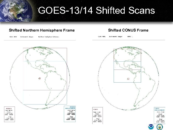 GOES-13/14 Shifted Scans Shifted Northern Hemisphere Frame Shifted CONUS Frame
 GOES-14 Post Launch Testing Ø GOES-O launched June 27, 2009 Ø GOES-O reached orbit at 90° W and has been renamed GOES-14 Ø Imager/Sounder data being served on Mc. IDAS ADDE Server on FTP: // West. nesdis. noaa. gov Ø NOAA Post Launch Science Test 11/30/09 – 1/4/2010 ü ü Ø Schedules at: http: //rammb. cira. colostate. edu/projects/goes-o/ Data and products to be made available to users GOES-14 to remain Earth pointing but imager/sounder off following PLT ü XRS to continue to operate Ø Change to imager band 6 (13 micron – from 8 km to 4 km) Ø Changes to GVAR: http: //www. osd. noaa. gov/gvardownload. htm
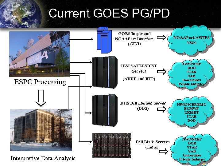 Current GOES PG/PD GOES Ingest and NOAAPort Interface (GINI) IBM SATEPSDIST Servers ESPC Processing (ADDE and FTP) Data Distribution Server (DDS) Dell Blade Servers (Linux) Interpretive Data Analysis NOAAPort/AWIPS NWS/NCEP DOD STAR SAB Universities Private Industry NWS/NCEP/EMC ECMWF UKMET STAR DOD NWS/NCEP DOD STAR SAB Universities Private Industry
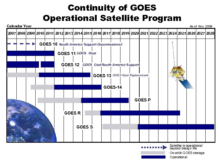 Continuity of GOES Operational Satellite Program Calendar Year As of Nov. 2009 2007 2008 2009 2010 2011 2012 2013 2014 2015 2016 2017 2018 2019 2020 2021 2022 2023 2024 2025 2026 2027 2028 GOES 10 South America Support-Decomissioned GOES 11 GOES 12 West GOES East/South America Support GOES 13 GOES-East Replacement GOES-14 GOES P GOES R GOES S Satellite is operational beyond design life On-orbit GOES storage Operational
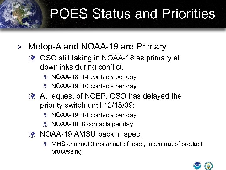 POES Status and Priorities Ø Metop-A and NOAA-19 are Primary ü OSO still taking in NOAA-18 as primary at downlinks during conflict: þ þ NOAA-18: 14 contacts per day NOAA-19: 10 contacts per day ü At request of NCEP, OSO has delayed the priority switch until 12/15/09: þ þ NOAA-19: 14 contacts per day NOAA-18: 8 contacts per day ü NOAA-19 AMSU back in spec. þ MHS channel 3 noise out of spec, taken out of product processing
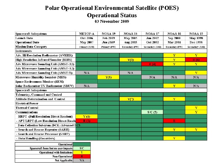 Polar Operational Environmental Satellite (POES) Operational Status 03 November 2009
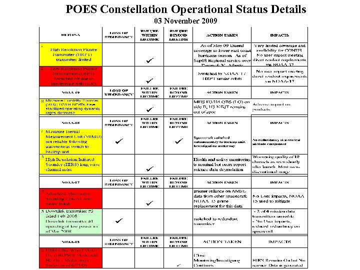 POES Constellation Operational Status Details 03 November 2009
 NPP Status Ø Launch delayed beyond January 2011 ü Operational products to be made available as early as three months following launch Ø At this time, a specific PLT schedule is not established and is currently under review by the Integrated Program Office Ø SDRs and EDRs will be made operationally available to the user community from the IDPS/NDE in net. CDF 4, HDF-5, and BUFR formats (radiances) Ø For current software documentation on data formats refer to URL: http: //jointmission. gsfc. nasa. gov/project/sciencedocuments. html
 NPP Status Ø The SDR/TDR Algorithm Theoretical Basis Documents (ATBD) for Cr. IS, ATMS, VIIRS, and OMPS are under review and being updated for general public release ü The ATBD for Cr. IS SDRs should be available in the short term þ þ Ø NESDIS will disseminate to the NAEDEX forum as soon as it is approved We’ll do the same when the other documents are released The NESDIS OSD has the action item to provide “user manuals” consisting of spectral response functions, etc. to the NAEDEX users
 NPP Product Development Annual Review for Satellite Product Development ü FY 10 NPP NOAA Unique Product Development Projects þ Microwave Integrated Retrieval System (MIRS) þ Cr. IS/ATMS Product System þ NDE Sea Surface Temperatures/Aerosol Product System þ Green Vegetation Fraction from NPP þ Polar Winds from VIIRS ü FY 11 NUP New Start Projects þ Blended Hyrdro-meteorological Product
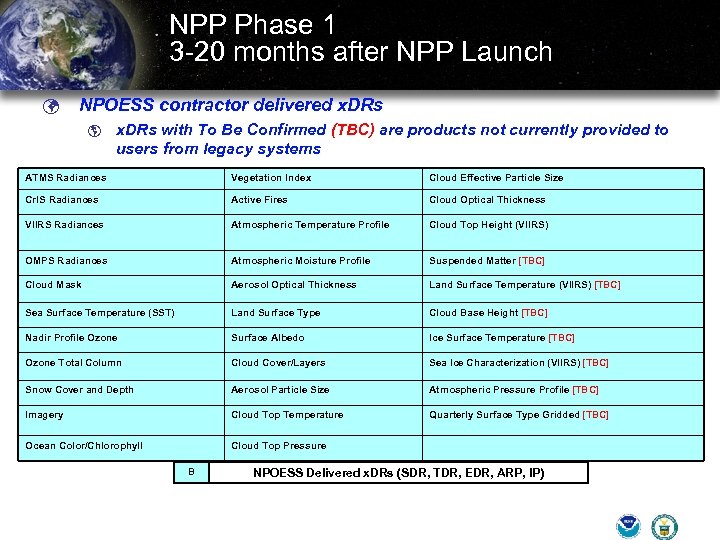 NPP Phase 1 3 -20 months after NPP Launch ü NPOESS contractor delivered x. DRs þ x. DRs with To Be Confirmed (TBC) are products not currently provided to users from legacy systems ATMS Radiances Vegetation Index Cloud Effective Particle Size Cr. IS Radiances Active Fires Cloud Optical Thickness VIIRS Radiances Atmospheric Temperature Profile Cloud Top Height (VIIRS) OMPS Radiances Atmospheric Moisture Profile Suspended Matter [TBC] Cloud Mask Aerosol Optical Thickness Land Surface Temperature (VIIRS) [TBC] Sea Surface Temperature (SST) Land Surface Type Cloud Base Height [TBC] Nadir Profile Ozone Surface Albedo Ice Surface Temperature [TBC] Ozone Total Column Cloud Cover/Layers Sea Ice Characterization (VIIRS) [TBC] Snow Cover and Depth Aerosol Particle Size Atmospheric Pressure Profile [TBC] Imagery Cloud Top Temperature Quarterly Surface Type Gridded [TBC] Ocean Color/Chlorophyll Cloud Top Pressure B NPOESS Delivered x. DRs (SDR, TDR, EDR, ARP, IP)
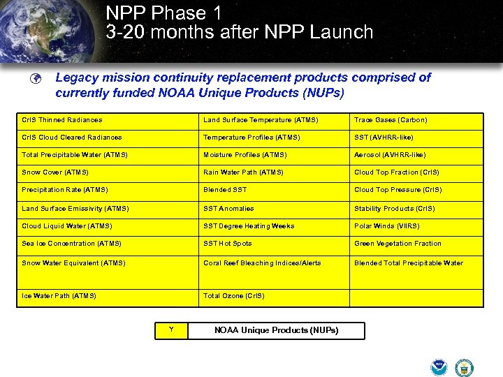 NPP Phase 1 3 -20 months after NPP Launch ü Legacy mission continuity replacement products comprised of currently funded NOAA Unique Products (NUPs) Cr. IS Thinned Radiances Land Surface Temperature (ATMS) Trace Gases (Carbon) Cr. IS Cloud Cleared Radiances Temperature Profiles (ATMS) SST (AVHRR-like) Total Precipitable Water (ATMS) Moisture Profiles (ATMS) Aerosol (AVHRR-like) Snow Cover (ATMS) Rain Water Path (ATMS) Cloud Top Fraction (Cr. IS) Precipitation Rate (ATMS) Blended SST Cloud Top Pressure (Cr. IS) Land Surface Emissivity (ATMS) SST Anomalies Stability Products (Cr. IS) Cloud Liquid Water (ATMS) SST Degree Heating Weeks Polar Winds (VIIRS) Sea Ice Concentration (ATMS) SST Hot Spots Green Vegetation Fraction Snow Water Equivalent (ATMS) Coral Reef Bleaching Indices/Alerts Blended Total Precipitable Water Ice Water Path (ATMS) Total Ozone (Cr. IS) Y NOAA Unique Products (NUPs)
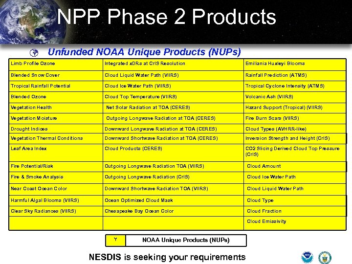 NPP Phase 2 Products ü Unfunded NOAA Unique Products (NUPs) Limb Profile Ozone Integrated x. DRs at Cr. IS Resolution Emiliania Huxleyi Blooms Blended Snow Cover Cloud Liquid Water Path (VIIRS) Rainfall Prediction (ATMS) Tropical Rainfall Potential Cloud Ice Water Path (VIIRS) Tropical Cyclone Intensity (ATMS) Blended Ozone Cloud Top Temperature (VIIRS) Volcanic Ash (VIIRS) Vegetation Health Net Solar Radiation at TOA (CERES) Hazard Support (Tropical) (VIIRS) Vegetation Moisture Outgoing Longwave Radiation at TOA (CERES) Fire Burn Scars (VIIRS) Drought Indices Downward Longwave Radiation at TOA (CERES) Cloud Types (AVHRR-like) Vegetation Thermal Conditions Downward Shortwave Radiation at TOA (CERES) Inversion Strength and Height (Cr. IS) Leaf Area Index Cloud Products (CERES) CO 2 Slicing Derived Cloud Top Pressure (Cr. IS) Fire Potential/Risk Outgoing Longwave Radiation TOA (VIIRS) Cloud Amount Fire & Smoke Analysis Outgoing Longwave Radiation (Cr. IS) Cloud Ice Water Path Near Coast Ocean Color Downward Shortwave Radiation TOA (VIIRS) Cloud Liquid Water Path Harmful Algal Blooms (VIIRS) Ocean Optimized Cloud Mask Cloud Type Clear Sky Radiances (VIIRS) Chesapeake Bay Ocean Color Cloud Fraction Cloud Emissivity Y NOAA Unique Products (NUPs) NESDIS is seeking your requirements
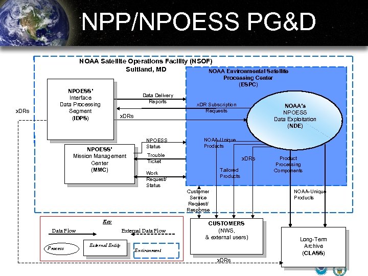 NPP/NPOESS PG&D NOAA Satellite Operations Facility (NSOF) Suitland, MD NOAA Environmental Satellite Processing Center (ESPC) x. DRs NPOESS’ Interface Data Processing Segment (IDPS) Data Delivery Reports x. DRs NPOESS’ Mission Management Center (MMC) NPOESS Status x. DR Subscription Requests NOAA’s NPOESS Data Exploitation (NDE) NOAA-Unique Products Trouble Ticket NOAA x. DRs Tailored Products Work Request/ Status Customer Service Request/ Response Key Data Flow Process External Data Flow External Entity Product Processing Components NOAA-Unique Products CUSTOMERS (NWS, & external users) Environment x. DRs Long-Term Archive (CLASS)
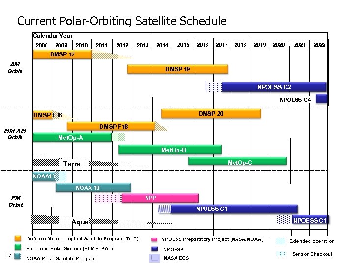 Current Polar-Orbiting Satellite Schedule Calendar Year 2008 2009 2010 2011 2012 2013 2014 2015 2016 2017 2018 2019 2020 2021 2022 DMSP 17 AM Orbit DMSP 19 NPOESS C 2 NPOESS C 4 DMSP 20 DMSP F 16 DMSP F 18 Mid AM Orbit Met. Op-A Met. Op-B Met. Op-C Terra NOAA 18 NOAA 19 PM Orbit NPP NPOESS C 1 NPOESS C 3 Aqua Defense Meteorological Satellite Program (Do. D) NPOESS Preparatory Project (NASA/NOAA) European Polar System (EUMETSAT) 24 NPOESS NOAA Polar Satellite Program NASA EOS Extended operation Sensor Checkout
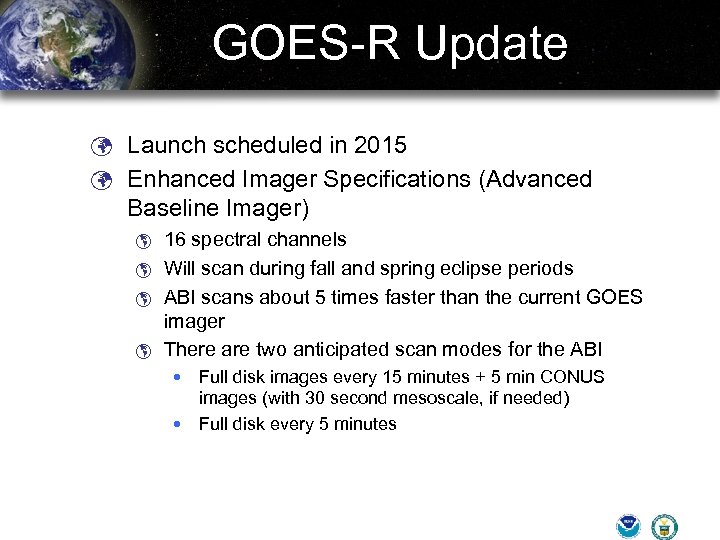 GOES-R Update ü Launch scheduled in 2015 ü Enhanced Imager Specifications (Advanced Baseline Imager) þ þ 16 spectral channels Will scan during fall and spring eclipse periods ABI scans about 5 times faster than the current GOES imager There are two anticipated scan modes for the ABI Full disk images every 15 minutes + 5 min CONUS images (with 30 second mesoscale, if needed) Full disk every 5 minutes
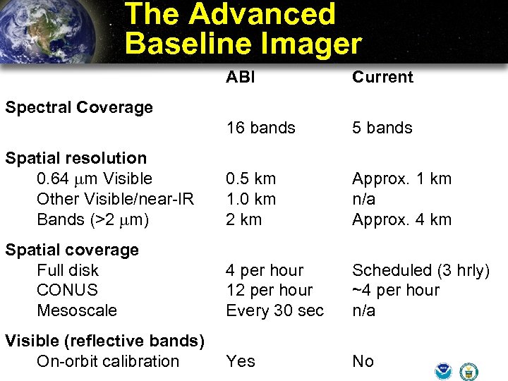 The Advanced Baseline Imager ABI Current 16 bands 5 bands Spatial resolution 0. 64 mm Visible Other Visible/near-IR Bands (>2 mm) 0. 5 km 1. 0 km 2 km Approx. 1 km n/a Approx. 4 km Spatial coverage Full disk CONUS Mesoscale 4 per hour 12 per hour Every 30 sec Scheduled (3 hrly) ~4 per hour n/a Visible (reflective bands) On-orbit calibration Yes No Spectral Coverage
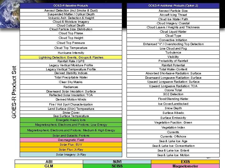
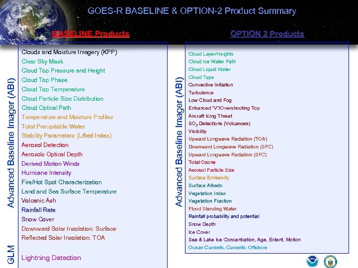 GOES-R BASELINE & OPTION-2 Product Summary BASELINE Products OPTION 2 Products Cloud Ice Water Path Cloud Top Pressure and Height Cloud Liquid Water Cloud Top Phase Cloud Type Cloud Top Temperature Cloud Particle Size Distribution Cloud Optical Path Temperature and Moisture Profiles Total Precipitable Water Stability Parameters (Lifted Index) Aerosol Detection Aerosols Optical Depth Derived Motion Winds Hurricane Intensity Fire/Hot Spot Characterization Land Sea Surface Temperature Volcanic Ash Rainfall Rate Snow Cover Downward Solar Insolation: Surface GLM Reflected Solar Insolation: TOA Advanced Baseline Imager (ABI) Cloud Layer/Heights Clear Sky Mask Advanced Baseline Imager (ABI) Clouds and Moisture Imagery (KPP) Convective Initiation Turbulence Low Cloud and Fog Enhanced “V”/Overshooting Top Aircraft Icing Threat SO 2 Detections (Volcanoes) Visibility Upward Longwave Radiation (TOA) Downward Longwave Radiation (SFC) Upward Longwave Radiation (SFC) Total Ozone Aerosol Particle Size Surface Emissivity Surface Albedo Vegetation Index Vegetation Fraction Flood Standing Water Rainfall probability and potential Snow Depth Ice Cover Sea & Lake Ice Concentration, Age, Extent, Motion Ocean Currents, Currents: Offshore Lightning Detection
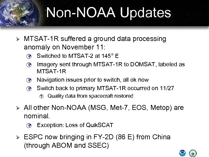 Non-NOAA Updates Ø MTSAT-1 R suffered a ground data processing anomaly on November 11: Switched to MTSAT-2 at 145° E ü Imagery sent through MTSAT-1 R to DOMSAT, labeled as MTSAT-1 R ü Navigation issues prior to switch, all ok now ü Switch back to primary MTSAT-1 R occurred on 11/27 ü þ Ø All other Non-NOAA (MSG, Met-7, EOS, Metop) are nominal. ü Ø Quality data from spacecraft restored Exception: Loss of Quik. SCAT ESPC now bringing in FY-2 D (86 E) from China (through ABOM and SSEC)
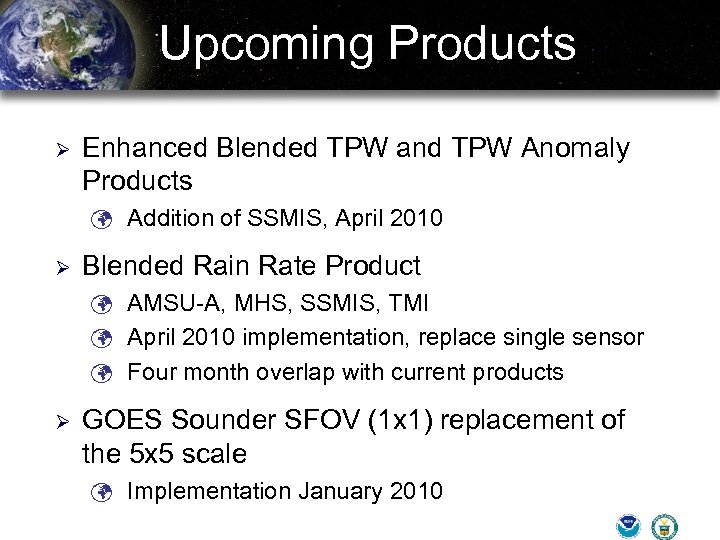 Upcoming Products Ø Enhanced Blended TPW and TPW Anomaly Products ü Addition of SSMIS, April 2010 Ø Blended Rain Rate Product ü AMSU-A, MHS, SSMIS, TMI ü April 2010 implementation, replace single sensor ü Four month overlap with current products Ø GOES Sounder SFOV (1 x 1) replacement of the 5 x 5 scale ü Implementation January 2010
 Back-Up Slides
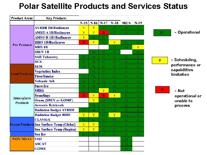 Polar Satellite Products and Services Status G - Operational - Scheduling, Y performance or capabilities limitation R - Not operational or unable to process
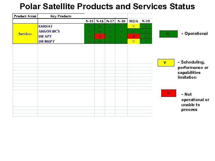 Polar Satellite Products and Services Status G - Operational - Scheduling, Y performance or capabilities limitation R - Not operational or unable to process
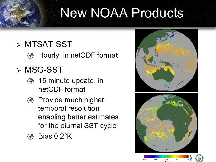 New NOAA Products Ø MTSAT-SST ü Hourly, in net. CDF format Ø MSG-SST ü 15 minute update, in net. CDF format ü Provide much higher temporal resolution enabling better estimates for the diurnal SST cycle ü Bias 0. 2°K
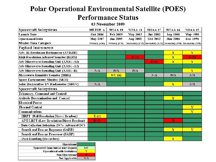 Polar Operational Environmental Satellite (POES) Performance Status 03 November 2009
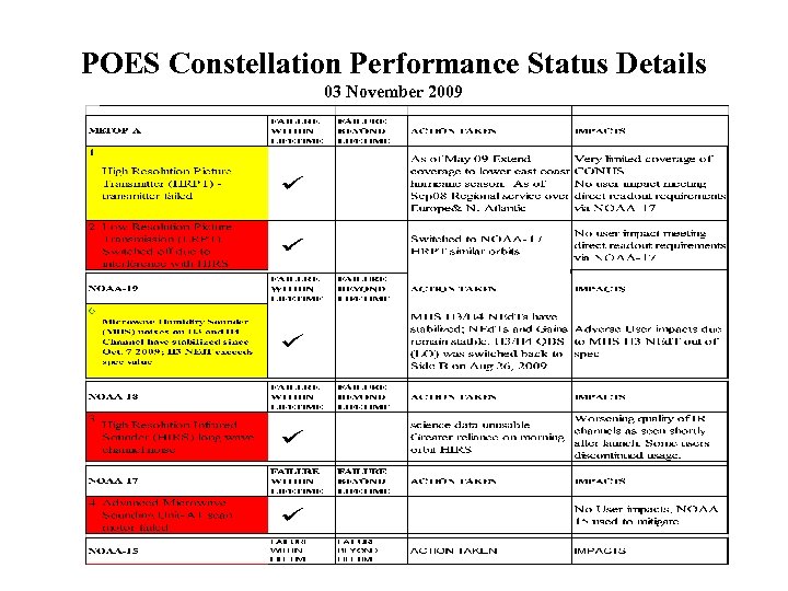 POES Constellation Performance Status Details 03 November 2009
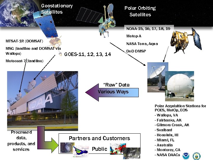 Geostationary Satellites Polar Orbiting Satellites NOAA-15, 16, 17, 18, 19 Metop-A MTSAT-1 R (DOMSAT) MSG (landline and DOMSAT via Wallops) NASA Terra, Aqua GOES-11, 12, 13, 14 Do. D DMSP Meteosat-7 (landline) “Raw” Data Various Ways Processed data, products, and services Partners and Customers Public Polar Acquisition Stations for POES, Met. Op, EOS - Wallops, VA - Fairbanks, AK - Gilmore Creek, AK - Svalbard - Honolulu, HI - Miami, FL - Australia - Monterey, CA - NASA DAACs
 GOES-R Baseline Products GOES-R Additional Products (Option 2) Aerosol Detection (incl Smoke & Dust) Suspended Matter / Optical Depth Volcanic Ash: Detection & Height Cloud & Moisture Imagery Cloud Optical Depth Cloud Particle Size Distribution Cloud Top Phase Aerosol Particle Size Aircraft Icing Threat Cloud Ice Water Path Cloud Imagery: Coastal Cloud Layers / Heights and Thickness Cloud Liquid Water Cloud Type Convective Initiation Enhanced “V” / Overshooting Top Detection Low Cloud and Fog Turbulence Visibility Probability of Rainfall Potential Total Water Content Absorbed Shortwave Radiation: Surface Downward Longwave Radiation: Surface Upward Longwave Radiation: TOA Ozone Total SO 2 Detection Flood/Standing Water Cloud Top Height Cloud Top Pressure GOES-R Product Set Cloud Top Temperature Hurricane Intensity Lightning Detection: Events, Groups & Flashes Rainfall Rate / QPE Legacy Vertical Moisture Profile Legacy Vertical Temperature Profile Derived Stability Indices Total Precipitable Water Clear Sky Masks Radiances Downward Solar Insolation: Surface Reflected Solar Insolation: TOA Derived Motion Winds Ice Cover/Landlocked Snow Depth Surface Albedo Fire / Hot Spot Characterization Land Surface (Skin) Temperature Snow Cover Sea Surface Temperature Energetic Heavy Ions Magnetospheric Electrons and Protons: Low Energy Surface Emissivity Vegetation Fraction: Green Magnetospheric Electrons and Protons: Medium & High Energy Solar and Galactic Protons Geomagnetic Field Solar Flux: EUV Solar Flux: X-Ray Sea & Lake Ice: Extent Sea & Lake Ice: Motion Solar Imagery: X-Ray ABI GLM Vegetation Index Currents: Offshore Sea & Lake Ice: Age Sea & Lake Ice: Concentration SUVI SEISS EXIS Magnetometer 37


