cba4e9763ccc9956b52042d94a4bf518.ppt
- Количество слайдов: 82
 NCEP Update: Review of Progress in Operational Weather, Climate and Ocean Forecasts Louis W. Uccellini Director, NCEP University of Maryland November 2, 2006 “Where America’s Climate, Weather and Ocean Prediction Services Begin”
 Overview • Define NCEP • “Seamless Suite” of forecast products: climate/weather linkage • Recent Advances – – – Seasonal to Interannual/Climate Forecast System Ocean Prediction/HYCOM “Medium range” Days 4 -7/North American Ensemble Forecast System Days 1 -3: Winter Weather Desk/Short-Range Ensemble Forecast System Joint Center for Satellite Data Assimilation • Performance Metrics • Future – Community Models – Multi-model Ensembles • New building – NOAA Center for Weather and Climate Prediction (Maryland) 2
 Define NCEP 3
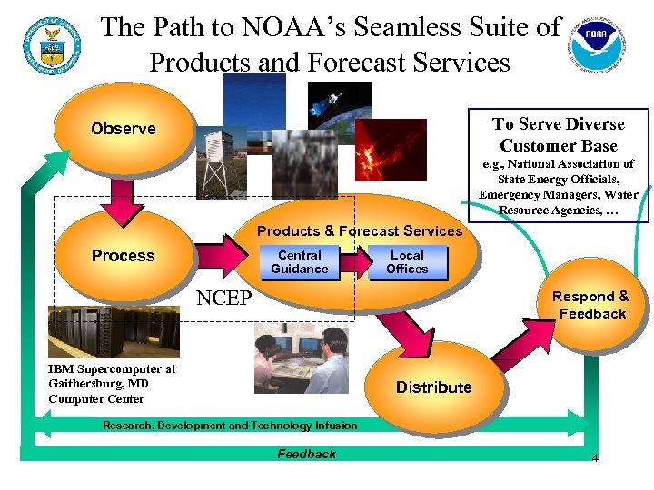 The Path to NOAA’s Seamless Suite of Products and Forecast Services To Serve Diverse Customer Base Observe e. g. , National Association of State Energy Officials, Emergency Managers, Water Resource Agencies, … Products & Forecast Services Process Central Guidance Local Offices NCEP Respond & Feedback IBM Supercomputer at Gaithersburg, MD Computer Center Distribute Research, Development and Technology Infusion Feedback 4
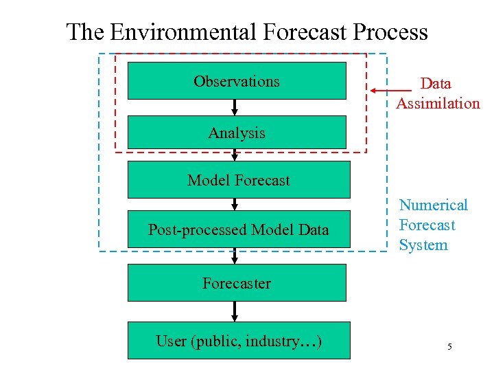 The Environmental Forecast Process Observations Data Assimilation Analysis Model Forecast Post-processed Model Data Numerical Forecast System Forecaster User (public, industry…) 5
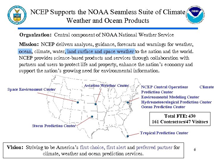 NCEP Supports the NOAA Seamless Suite of Climate Weather and Ocean Products Organization: Central component of NOAA National Weather Service Mission: NCEP delivers analyses, guidance, forecasts and warnings for weather, ocean, climate, water, land surface and space weather to the nation and the world. NCEP provides science-based products and services through collaboration with partners and users to protect life and property, enhance the nation’s economy and support the nation’s growing need for environmental information. Space Environment Center Storm Prediction Center Aviation Weather Center NCEP Central Operations Climate Prediction Center Environmental Modeling Center Hydrometeorological Prediction Center Ocean Prediction Center Total FTE: 430 161 Contractors/47 Visitors Tropical Prediction Center Vision: Striving to be America’s first choice, first alert and preferred partner for climate, weather and ocean prediction services. 6
 NCEP Employment Summary • Civil Service Positions – 430 civil servant positions – Average 32 hires/year at all levels – 2 -4 entry-level hires/year • Contract Positions – Average 140 contractors/year (over last 4 years) – Currently have 161 contractors – Approximately 28 contractor vacancies/year • Student Programs – Average number of student interns - 6 (SCEP/STEP) http: //www. weather. gov/eeo/Student. Research. Opportunities. htm) – 16 Summer hires in 2006 through various programs (http: //epp. noaa. gov/ , http: //www. oesd. noaa. gov/Hollings_info. html ) 7
 What Does NCEP Do? “From the Sun to the Sea” • • Solar Monitoring, Warnings and Forecasts Climate Forecasts: Weekly to Seasonal to Interannual El Nino – La Nina Forecast Weather Forecasts to Day 7 Hurricanes, Severe Weather, Snowstorms, Fire Weather Aviation (Turbulence, Icing) High Seas Forecasts and Warnings ? Model Development, Implementation and Applications for Global and Regional Weather, Climate, Oceans and now Space Weather ? International and National Partnerships in Ensemble Forecasts ? Data Assimilation including the Joint Center for Satellite Data Assimilation ? Super Computer, Workstation and Network Operations 8 ? Transition Test Beds Being Developed throughout NCEP
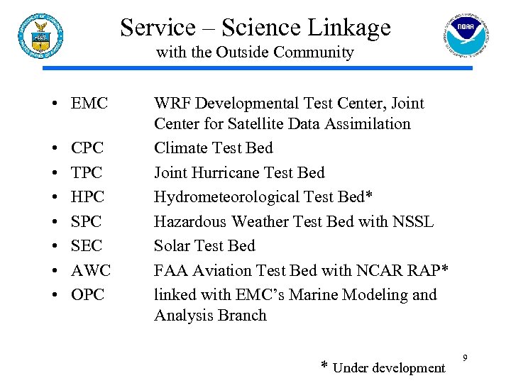 Service – Science Linkage with the Outside Community • EMC • • CPC TPC HPC SEC AWC OPC WRF Developmental Test Center, Joint Center for Satellite Data Assimilation Climate Test Bed Joint Hurricane Test Bed Hydrometeorological Test Bed* Hazardous Weather Test Bed with NSSL Solar Test Bed FAA Aviation Test Bed with NCAR RAP* linked with EMC’s Marine Modeling and Analysis Branch * Under development 9
 Seamless Suite of Forecast Products Climate-Weather Linkage 10
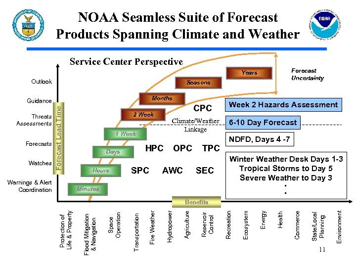 NOAA Seamless Suite of Forecast Products Spanning Climate and Weather Service Center Perspective Forecast Uncertainty Years Outlook Seasons Months Warnings & Alert Coordination HPC Days Hours SPC OPC AWC TPC SEC Week 2 Hazards Assessment 6 -10 Day Forecast NDFD, Days 4 -7 Winter Weather Desk Days 1 -3 Tropical Storms to Day 5 Severe Weather to Day 3 • • Minutes 11 Environment State/Local Planning Commerce Health Energy Ecosystem Recreation Reservoir Control Agriculture Hydropower Fire Weather Protection of Life & Property Benefits Transportation Watches Climate/Weather Linkage 1 Week Space Operation Forecasts CPC 2 Week Flood Mitigation & Navigation Threats Assessments Forecast Lead Time Guidance
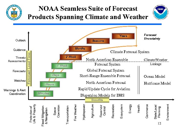 NOAA Seamless Suite of Forecast Products Spanning Climate and Weather Forecast Uncertainty Years Outlook Seasons Months Climate/Weather Linkage Global Forecast System Short-Range Ensemble Forecast Days Ocean Model North American Forecast Hours Hurricane Model Rapid Update Cycle for Aviation Warnings & Alert Coordination Minutes Dispersion Models for DHS 12 Environment State/Local Planning Commerce Health Energy Ecosystem Recreation Reservoir Control Agriculture Hydropower Fire Weather Protection of Life & Property Benefits Transportation Watches Climate Forecast System North American Ensemble Forecast System 1 Week Space Operation Forecasts 2 Week Flood Mitigation & Navigation Threats Assessments Forecast Lead Time Guidance
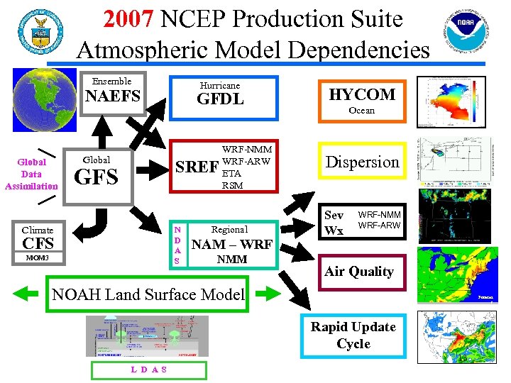 2007 NCEP Production Suite Atmospheric Model Dependencies Ensemble Hurricane NAEFS Global Data Assimilation Global GFDL SREF GFS Climate N D A S CFS MOM 3 WRF-NMM WRF-ARW ETA RSM Regional NAM – WRF NMM HYCOM Ocean Dispersion Sev Wx WRF-NMM WRF-ARW Air Quality NOAH Land Surface Model Forecas t Rapid Update Cycle 13 L D A S
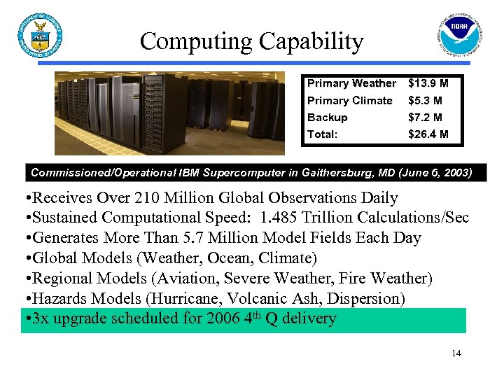 Computing Capability Primary Weather $13. 9 M Primary Climate Backup $5. 3 M $7. 2 M Total: $26. 4 M Commissioned/Operational IBM Supercomputer in Gaithersburg, MD (June 6, 2003) • Receives Over 210 Million Global Observations Daily • Sustained Computational Speed: 1. 485 Trillion Calculations/Sec • Generates More Than 5. 7 Million Model Fields Each Day • Global Models (Weather, Ocean, Climate) • Regional Models (Aviation, Severe Weather, Fire Weather) • Hazards Models (Hurricane, Volcanic Ash, Dispersion) • 3 x upgrade scheduled for 2006 4 th Q delivery 14
 Recent Advances 15
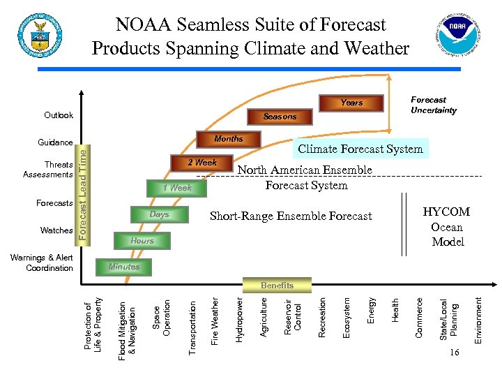 NOAA Seamless Suite of Forecast Products Spanning Climate and Weather Forecast Uncertainty Years Outlook Seasons Months Warnings & Alert Coordination Climate Forecast System North American Ensemble Forecast System HYCOM Ocean Model Short-Range Ensemble Forecast Days Hours Minutes 16 Environment State/Local Planning Commerce Health Energy Ecosystem Recreation Reservoir Control Agriculture Hydropower Fire Weather Protection of Life & Property Benefits Transportation Watches 1 Week Space Operation Forecasts 2 Week Flood Mitigation & Navigation Threats Assessments Forecast Lead Time Guidance
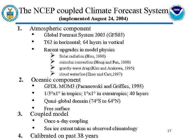 The NCEP coupled Climate Forecast System (implemented August 24, 2004) 1. 2. 3. 4. Atmospheric component • • • Global Forecast System 2003 (GFS 03) T 62 in horizontal; 64 layers in vertical Recent upgrades in model physics • • GFDL MOM 3 (Pacanowski and Griffies, 1998) 1/3°x 1° in tropics; 1°x 1° in extratropics; 40 layers Quasi-global domain (74°S to 64°N) Free surface • • Once-a-day coupling Sea ice extent taken as observed climatology Ø Solar radiation (Hou, 1996) Ø cumulus convection (Hong and Pan, 1998) Ø gravity wave drag (Kim and Arakawa, 1995) Ø cloud water/ice (Zhao and Carr, 1997) Oceanic component Coupled model Calibrated on past 38 years 17
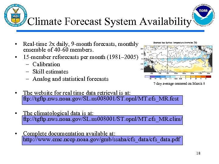 Climate Forecast System Availability • Real-time 2 x daily, 9 -month forecasts, monthly ensemble of 40 -60 members. • 15 -member reforecasts per month (1981– 2005) – Calibration – Skill estimates – Analog and statistical forecasts 7 day average centered on March 8 • The website for real time data retrieval is at: ftp: //tgftp. nws. noaa. gov/SL. us 008001/ST. opnl/MT. cfs_MR. fcst • The climatological data is at: ftp: //tgftp. nws. noaa. gov/SL. us 008001/ST. opnl/MT. cfs_MR. clim/ • Complete documentation available at: http: //www. emc. ncep. noaa. gov/gmb/ssaha/cfs_data. pdf 18
 19
19
 20
20
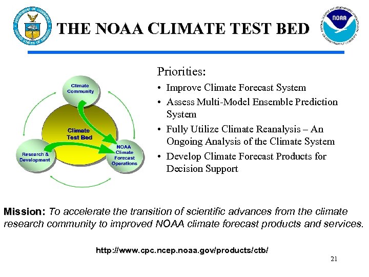 THE NOAA CLIMATE TEST BED Priorities: • Improve Climate Forecast System • Assess Multi-Model Ensemble Prediction System • Fully Utilize Climate Reanalysis – An Ongoing Analysis of the Climate System • Develop Climate Forecast Products for Decision Support Mission: To accelerate the transition of scientific advances from the climate research community to improved NOAA climate forecast products and services. http: //www. cpc. ncep. noaa. gov/products/ctb/ 21
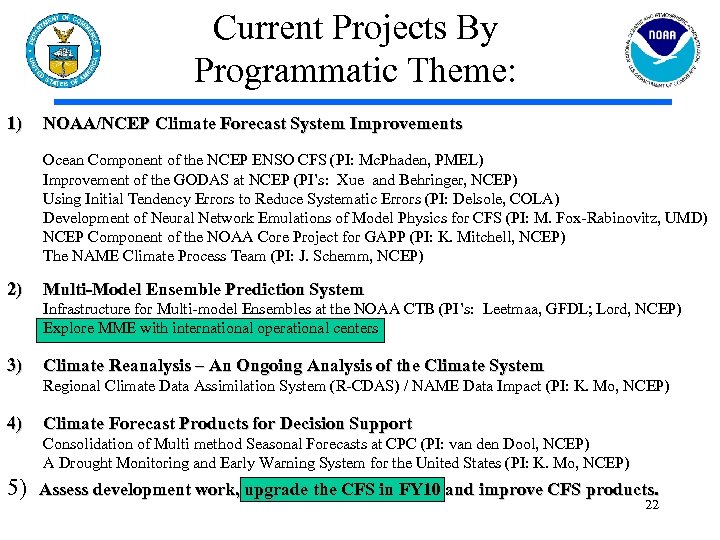 Current Projects By Programmatic Theme: 1) NOAA/NCEP Climate Forecast System Improvements Ocean Component of the NCEP ENSO CFS (PI: Mc. Phaden, PMEL) Improvement of the GODAS at NCEP (PI’s: Xue and Behringer, NCEP) Using Initial Tendency Errors to Reduce Systematic Errors (PI: Delsole, COLA) Development of Neural Network Emulations of Model Physics for CFS (PI: M. Fox-Rabinovitz, UMD) NCEP Component of the NOAA Core Project for GAPP (PI: K. Mitchell, NCEP) The NAME Climate Process Team (PI: J. Schemm, NCEP) 2) Multi-Model Ensemble Prediction System Infrastructure for Multi-model Ensembles at the NOAA CTB (PI’s: Leetmaa, GFDL; Lord, NCEP) Explore MME with international operational centers 3) Climate Reanalysis – An Ongoing Analysis of the Climate System Regional Climate Data Assimilation System (R-CDAS) / NAME Data Impact (PI: K. Mo, NCEP) 4) Climate Forecast Products for Decision Support Consolidation of Multi method Seasonal Forecasts at CPC (PI: van den Dool, NCEP) A Drought Monitoring and Early Warning System for the United States (PI: K. Mo, NCEP) 5) Assess development work, upgrade the CFS in FY 10 and improve CFS products. 22
 Ocean Prediction • NCEP to provide “backbone” support for operational delivery of ocean model forecasts – In response to NOAA Science Advisory Board Report 23
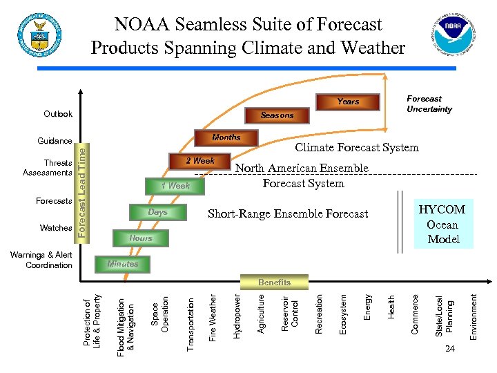 NOAA Seamless Suite of Forecast Products Spanning Climate and Weather Forecast Uncertainty Years Outlook Seasons Months Warnings & Alert Coordination Climate Forecast System North American Ensemble Forecast System HYCOM Ocean Model Short-Range Ensemble Forecast Days Hours Minutes 24 Environment State/Local Planning Commerce Health Energy Ecosystem Recreation Reservoir Control Agriculture Hydropower Fire Weather Protection of Life & Property Benefits Transportation Watches 1 Week Space Operation Forecasts 2 Week Flood Mitigation & Navigation Threats Assessments Forecast Lead Time Guidance
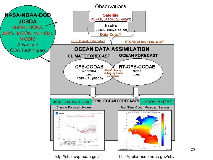 Observations NASA-NOAA-DOD JCSDA Satellite (AVHRR, JASON, Quik. SCAT) AMSR, GOES, AIRS, JASON, Wind. Sat, MODIS Advanced ODA Techniques In situ (ARGO, Buoys, Ships) Data Cutoff CFS: 2 week data cutoff RTOFS: 24 hour data cutoff OCEAN DATA ASSIMILATION CLIMATE FORECAST CFS-GODAS NCO/ODA EMC NOPP-JPL (ECCO) MOM-3 MOM-4 HOME OCEAN FORECAST RT-OFS-GODAE Shared history, coding, and data processing NOPP EMC OPNL OCEAN FORECASTS HYCOM HOME Climate Forecast System Real-Time Ocean Forecast System 25 http: //cfs. ncep. noaa. gov/ http: //polar. ncep. noaa. gov/ofs/
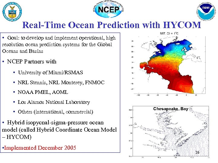 Real-Time Ocean Prediction with HYCOM • Goal: to develop and implement operational, high resolution ocean prediction systems for the Global Oceans and Basins • NCEP Partners with • University of Miami/RSMAS • NRL Stennis, NRL Monterey, FNMOC • NOAA PMEL, AOML • Los Alamos National Laboratory • Others (international, commercial) Chesapeake Bay • Hybrid isopycnal-sigma-pressure ocean model (called Hybrid Coordinate Ocean Model – HYCOM) • Implemented December 2005 26
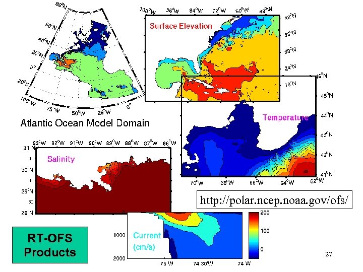 http: //polar. ncep. noaa. gov/ofs/ RT-OFS Products 27
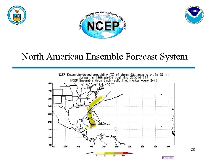 North American Ensemble Forecast System 28
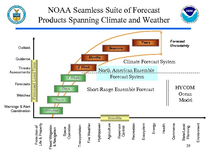 NOAA Seamless Suite of Forecast Products Spanning Climate and Weather Forecast Uncertainty Years Outlook Seasons Months Warnings & Alert Coordination Climate Forecast System North American Ensemble Forecast System HYCOM Ocean Model Short-Range Ensemble Forecast Days Hours Minutes 29 Environment State/Local Planning Commerce Health Energy Ecosystem Recreation Reservoir Control Agriculture Hydropower Fire Weather Protection of Life & Property Benefits Transportation Watches 1 Week Space Operation Forecasts 2 Week Flood Mitigation & Navigation Threats Assessments Forecast Lead Time Guidance
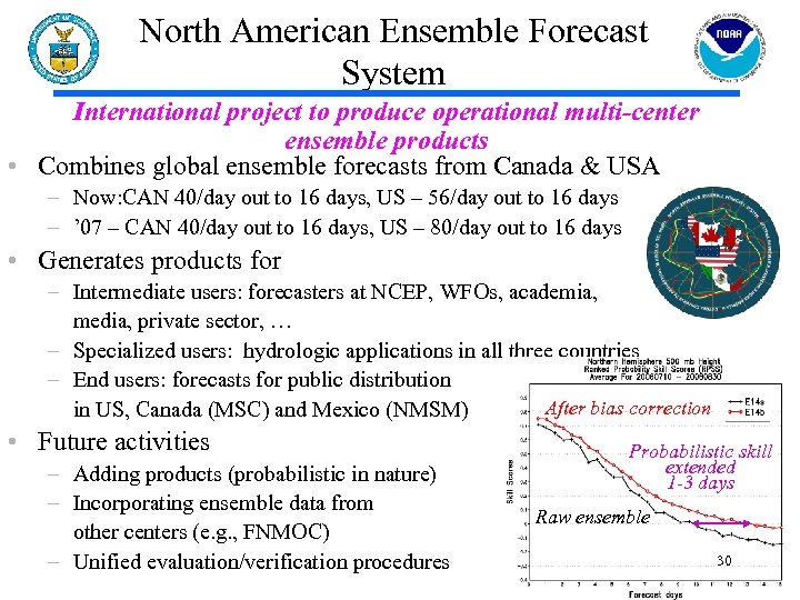 North American Ensemble Forecast System International project to produce operational multi-center ensemble products • Combines global ensemble forecasts from Canada & USA – Now: CAN 40/day out to 16 days, US – 56/day out to 16 days – ’ 07 – CAN 40/day out to 16 days, US – 80/day out to 16 days • Generates products for – Intermediate users: forecasters at NCEP, WFOs, academia, media, private sector, … – Specialized users: hydrologic applications in all three countries – End users: forecasts for public distribution After bias correction in US, Canada (MSC) and Mexico (NMSM) • Future activities – Adding products (probabilistic in nature) – Incorporating ensemble data from other centers (e. g. , FNMOC) – Unified evaluation/verification procedures Probabilistic skill extended 1 -3 days Raw ensemble 30
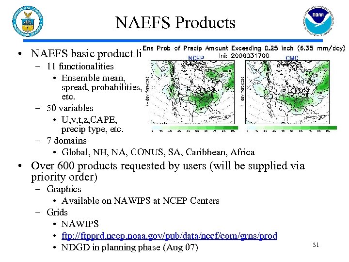 NAEFS Products • NAEFS basic product list – 11 functionalities • Ensemble mean, spread, probabilities, etc. – 50 variables • U, v, t, z, CAPE, precip type, etc. – 7 domains • Global, NH, NA, CONUS, SA, Caribbean, Africa • Over 600 products requested by users (will be supplied via priority order) – Graphics • Available on NAWIPS at NCEP Centers – Grids • NAWIPS • ftp: //ftpprd. ncep. noaa. gov/pub/data/nccf/com/grns/prod • NDGD in planning phase (Aug 07) 31
 Short-Range Ensemble Forecast System 32
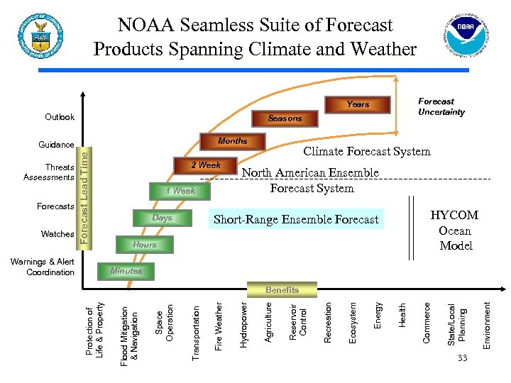 NOAA Seamless Suite of Forecast Products Spanning Climate and Weather Forecast Uncertainty Years Outlook Seasons Months Warnings & Alert Coordination Climate Forecast System North American Ensemble Forecast System HYCOM Ocean Model Short-Range Ensemble Forecast Days Hours Minutes 33 Environment State/Local Planning Commerce Health Energy Ecosystem Recreation Reservoir Control Agriculture Hydropower Fire Weather Protection of Life & Property Benefits Transportation Watches 1 Week Space Operation Forecasts 2 Week Flood Mitigation & Navigation Threats Assessments Forecast Lead Time Guidance
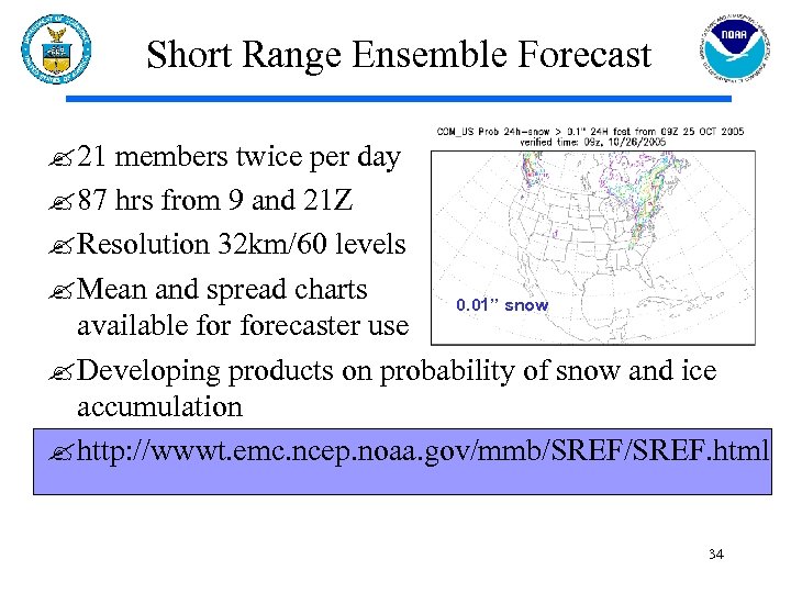 Short Range Ensemble Forecast ? 21 members twice per day ? 87 hrs from 9 and 21 Z ? Resolution 32 km/60 levels ? Mean and spread charts 0. 01” snow available forecaster use ? Developing products on probability of snow and ice accumulation ? http: //wwwt. emc. ncep. noaa. gov/mmb/SREF. html 34
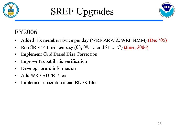 SREF Upgrades FY 2006 • • Added six members twice per day (WRF ARW & WRF NMM) (Dec ‘ 05) Run SREF 4 times per day (03, 09, 15 and 21 UTC) (June, 2006) Implement Grid Based Bias Correction Improve Probabilistic verification Develop spread information Add WRF BUFR Files Implement ensemble mean BUFR files 35
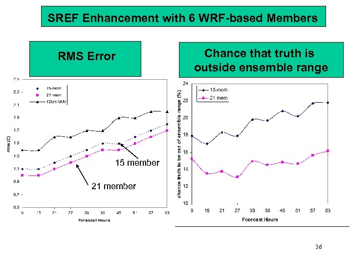 SREF Enhancement with 6 WRF-based Members RMS Error Chance that truth is outside ensemble range 15 member 21 member 36
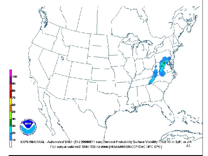
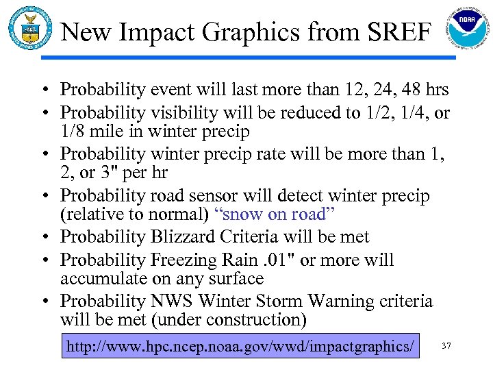 New Impact Graphics from SREF • Probability event will last more than 12, 24, 48 hrs • Probability visibility will be reduced to 1/2, 1/4, or 1/8 mile in winter precip • Probability winter precip rate will be more than 1, 2, or 3" per hr • Probability road sensor will detect winter precip (relative to normal) “snow on road” • Probability Blizzard Criteria will be met • Probability Freezing Rain. 01" or more will accumulate on any surface • Probability NWS Winter Storm Warning criteria will be met (under construction) http: //www. hpc. ncep. noaa. gov/wwd/impactgraphics/ 37
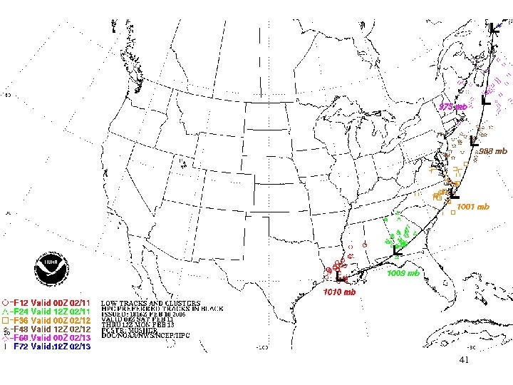
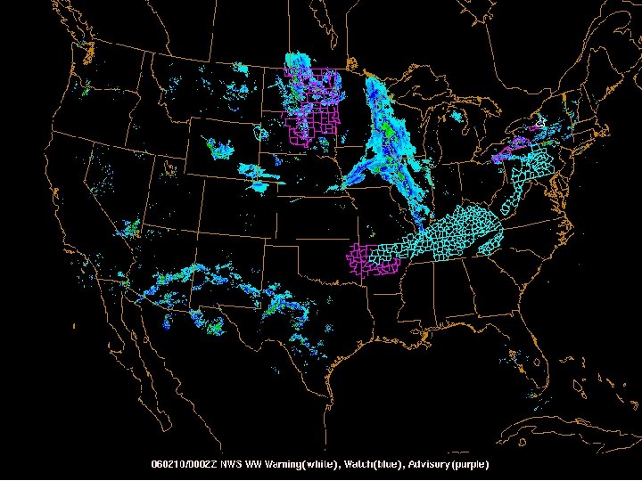
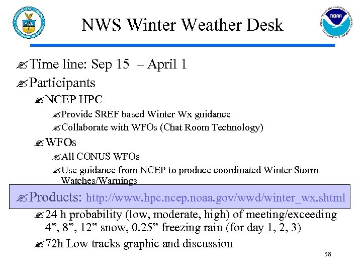 NWS Winter Weather Desk ? Time line: Sep 15 – April 1 ? Participants ? NCEP HPC ? Provide SREF based Winter Wx guidance ? Collaborate with WFOs (Chat Room Technology) ? WFOs ? All CONUS WFOs ? Use guidance from NCEP to produce coordinated Winter Storm Watches/Warnings ? Products: http: //www. hpc. ncep. noaa. gov/wwd/winter_wx. shtml ? 24 h probability (low, moderate, high) of meeting/exceeding 4”, 8”, 12” snow, 0. 25” freezing rain (for day 1, 2, 3) ? 72 h Low tracks graphic and discussion 38
 39
39
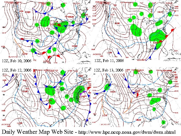 12 Z, Feb 10, 2006 12 Z, Feb 11, 2006 12 Z, Feb 12, 2006 12 Z, Feb 13, 2006 40 Daily Weather Map Web Site - http: //www. hpc. ncep. noaa. gov/dwm. shtml
 41
41
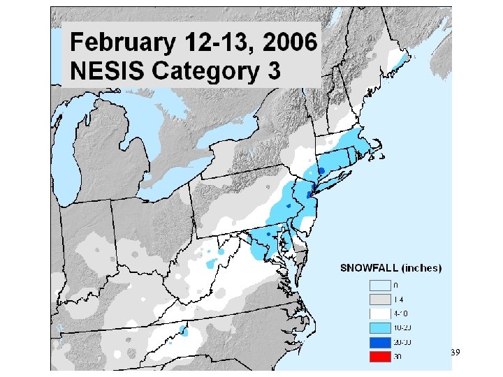
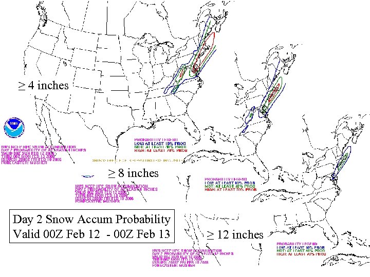 ≥ 4 inches ≥ 8 inches Day 2 Snow Accum Probability Valid 00 Z Feb 12 - 00 Z Feb 13 ≥ 12 inches 42
 43
43
 44
44
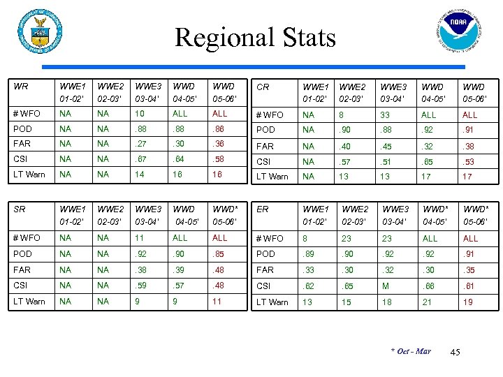 Regional Stats WR WWE 1 01 -02’ WWE 2 02 -03’ WWE 3 03 -04’ WWD 04 -05’ WWD 05 -06’ CR WWE 1 01 -02’ WWE 2 02 -03’ WWE 3 03 -04’ WWD 04 -05’ WWD 05 -06’ # WFO NA NA 10 ALL # WFO NA 8 33 ALL POD NA NA . 88 . 86 POD NA . 90 . 88 . 92 . 91 FAR NA NA . 27 . 30 . 36 FAR NA . 40 . 45 . 32 . 38 CSI NA NA . 67 . 64 . 58 CSI NA . 57 . 51 . 65 . 53 LT Warn NA NA 14 16 16 LT Warn NA 13 13 17 17 SR WWE 1 01 -02’ WWE 2 02 -03’ WWE 3 03 -04’ WWD 04 -05’ WWD* 05 -06’ ER WWE 1 01 -02’ WWE 2 02 -03’ WWE 3 03 -04’ WWD* 04 -05’ WWD* 05 -06’ # WFO NA NA 11 ALL # WFO 8 23 23 ALL POD NA NA . 92 . 90 . 85 POD . 89 . 90 . 92 . 91 FAR NA NA . 38 . 39 . 48 FAR . 33 . 30 . 32 . 30 . 35 CSI NA NA . 59 . 57 . 48 CSI . 62 . 65 M . 66 . 61 LT Warn NA NA 9 9 11 LT Warn 13 15 18 21 19 * Oct - Mar 45
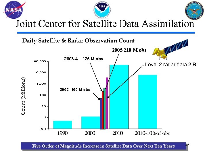 Joint Center for Satellite Data Assimilation Daily Satellite & Radar Observation Count 2005 210 M obs 2003 -4 125 M obs Count (Millions) Level 2 radar data 2 B 2002 100 M obs 1990 2000 2010 -10%of obs Five Order of Magnitude Increase in Satellite Data Over Next Ten Years 46
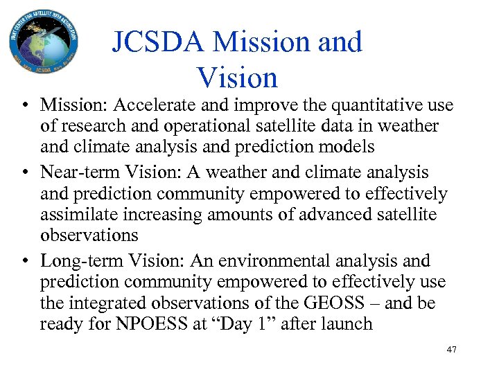 JCSDA Mission and Vision • Mission: Accelerate and improve the quantitative use of research and operational satellite data in weather and climate analysis and prediction models • Near-term Vision: A weather and climate analysis and prediction community empowered to effectively assimilate increasing amounts of advanced satellite observations • Long-term Vision: An environmental analysis and prediction community empowered to effectively use the integrated observations of the GEOSS – and be ready for NPOESS at “Day 1” after launch 47
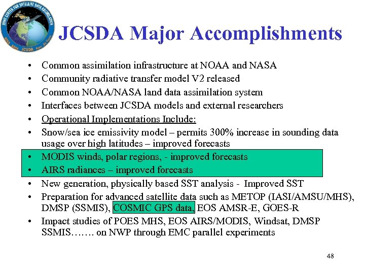 JCSDA Major Accomplishments • • • Common assimilation infrastructure at NOAA and NASA Community radiative transfer model V 2 released Common NOAA/NASA land data assimilation system Interfaces between JCSDA models and external researchers Operational Implementations Include: Snow/sea ice emissivity model – permits 300% increase in sounding data usage over high latitudes – improved forecasts MODIS winds, polar regions, - improved forecasts AIRS radiances – improved forecasts New generation, physically based SST analysis - Improved SST Preparation for advanced satellite data such as METOP (IASI/AMSU/MHS), DMSP (SSMIS), COSMIC GPS data, EOS AMSR-E, GOES-R Impact studies of POES MHS, EOS AIRS/MODIS, Windsat, DMSP SSMIS……. on NWP through EMC parallel experiments 48
 Figure 3(b). 500 h. Pa Z Anomaly Correlations for the GFS with (Ops. +AIRS) and without 49 (Ops. ) AIRS data, Northern hemisphere, January 2004
 Impact of AIRS increased spatial data density/improved QC (Snow, SSI/eo/April 2005/nw) 50
 Performance Metrics -- Models -- 51
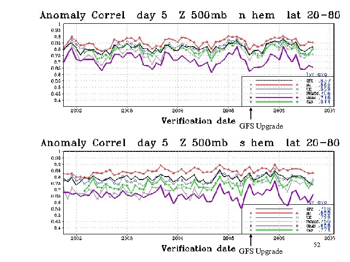 GFS Upgrade 52
 53
53
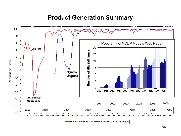 Comms Upgrade Number of Hits (Millions) Popularity of NCEP Models Web Page 2001 2002 2003 2004 2005 2006 54
 Performance Metrics -- Forecasters -- 55
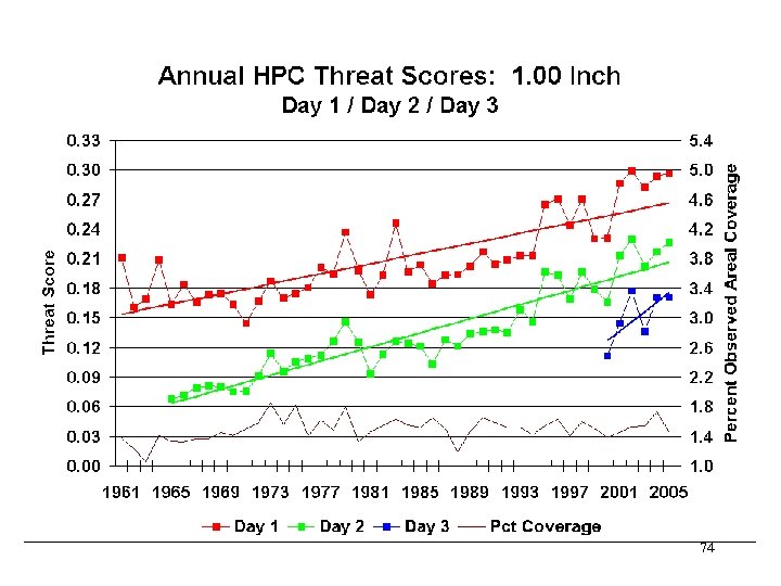
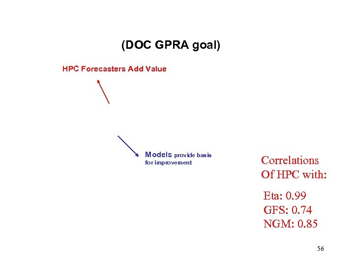 (DOC GPRA goal) HPC Forecasters Add Value Models provide basis for improvement Correlations Of HPC with: Eta: 0. 99 GFS: 0. 74 NGM: 0. 85 56
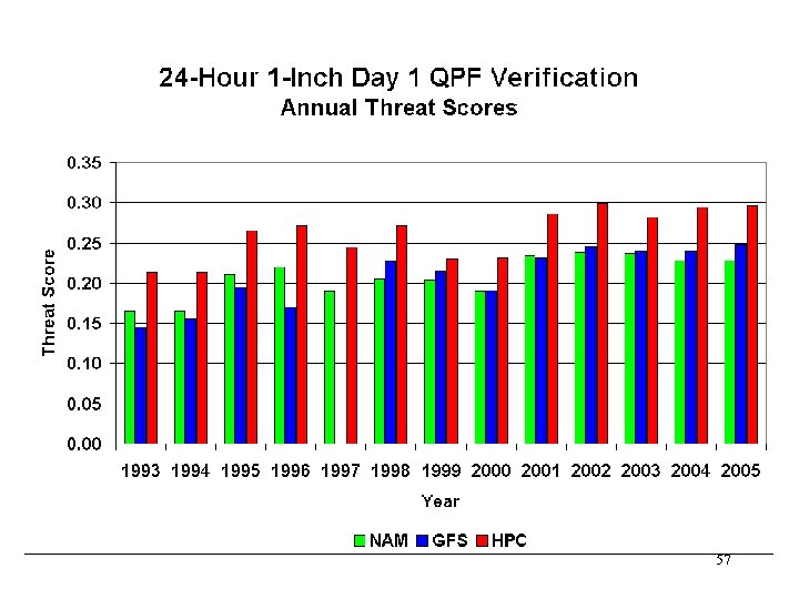 57
57
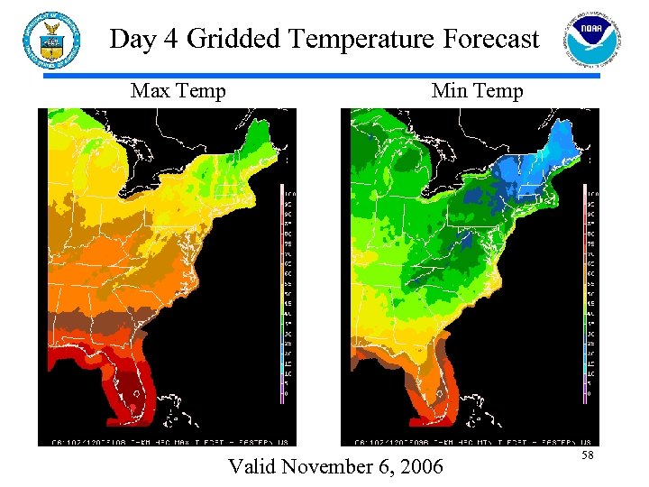 Day 4 Gridded Temperature Forecast Max Temp Min Temp Valid November 6, 2006 58
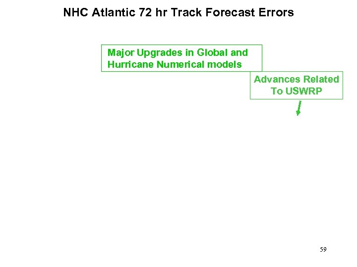 NHC Atlantic 72 hr Track Forecast Errors Major Upgrades in Global and Hurricane Numerical models Advances Related To USWRP 59
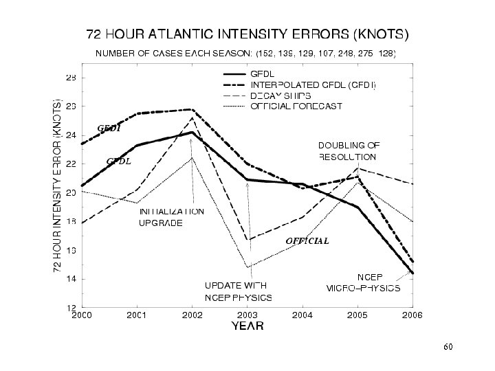 60
60
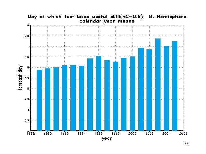
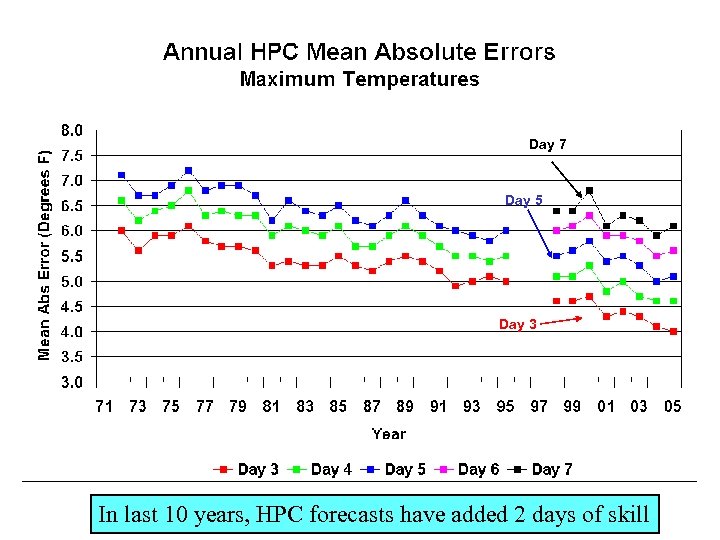 Day 7 Day 5 Day 3 In last 10 years, HPC forecasts have added 2 days of skill
 Future • Community Models • Multi-Model Ensembles 62
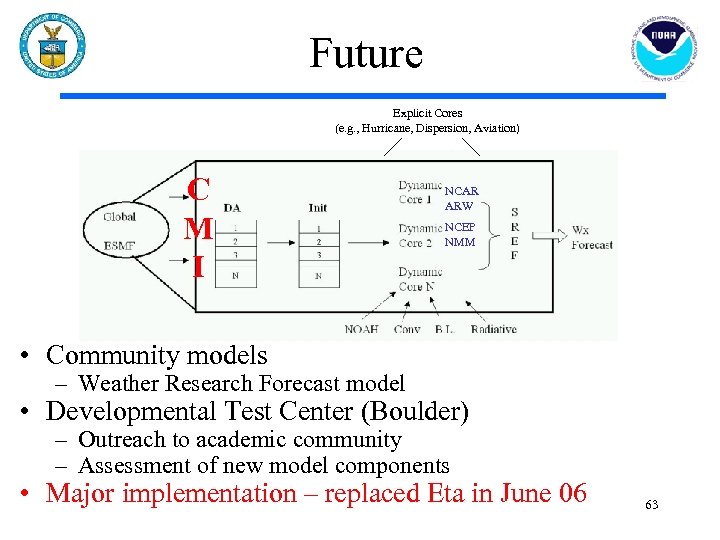 Future Explicit Cores (e. g. , Hurricane, Dispersion, Aviation) C M I NCAR ARW NCEP NMM • Community models – Weather Research Forecast model • Developmental Test Center (Boulder) – Outreach to academic community – Assessment of new model components • Major implementation – replaced Eta in June 06 63
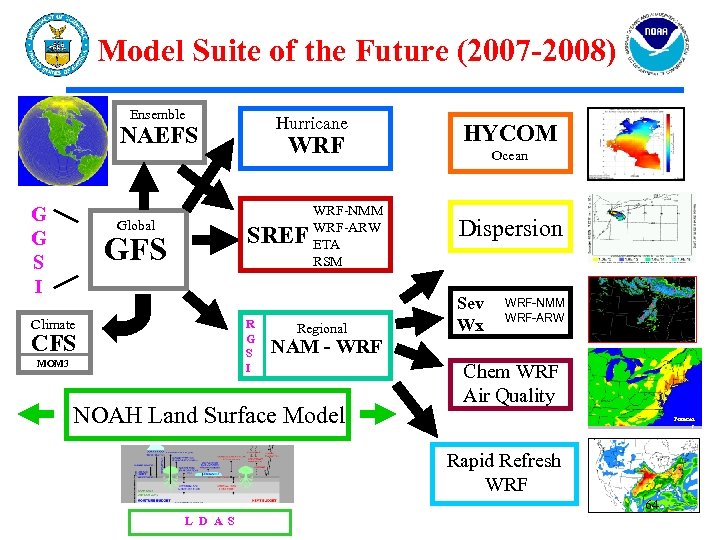 Model Suite of the Future (2007 -2008) Ensemble Hurricane NAEFS G G S I Global WRF SREF GFS Climate R G S I CFS MOM 3 WRF-NMM WRF-ARW ETA RSM Regional HYCOM Ocean Dispersion Sev Wx WRF-NMM WRF-ARW NAM - WRF NOAH Land Surface Model Chem WRF Air Quality Forecas t Rapid Refresh WRF 64 L D A S
 Multi-Model Ensembles Issue • In 5 -10 years will all forecasts be based on multi-model ensemble approach? • Climate Forecast System • North American Ensemble Forecast System • Short-Range Ensemble Forecast System • Oceans • Space Weather • Answer(s) will have enormous implications for NCEP operational computer allocations 65
 Multi-Model Ensembles • Enormous implications for NCEP links to the research community • How do we link all the players? • Operational centers • NCAR/NASA/DOE/Universities • How do we link data assimilation infrastructure (all data types)? • Ensemble-based Kalman Filter • 3 D or 4 D Var • How do we factor into transition process? • Research to Operations AND Operations to Research • Many issues will influence NCEP’s participation in THORPEX (Zoltan Toth, focal point) 66
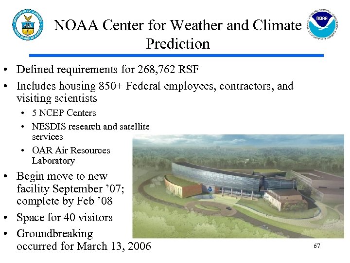 NOAA Center for Weather and Climate Prediction • Defined requirements for 268, 762 RSF • Includes housing 850+ Federal employees, contractors, and visiting scientists • 5 NCEP Centers • NESDIS research and satellite services • OAR Air Resources Laboratory • Begin move to new facility September ’ 07; complete by Feb ’ 08 • Space for 40 visitors • Groundbreaking occurred for March 13, 2006 67
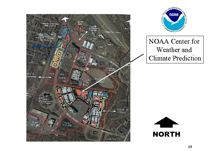 NOAA Center for Weather and Climate Prediction NORTH 68
 Summary • NCEP spanning “Sun to the Sea”; many new programmatic areas (oceans, air quality, space weather…) • Many science-service opportunities/challenges exist • NCEP is uniquely positioned to handle transition issues from research to operations • Actively engaged with the research community – Test beds – Experiments (NAME, THORPEX) – Other programs (USWRP, CLIVAR, …) • Still consider NCEP to be an underutilized entity by the research community 69
 Appendix 70
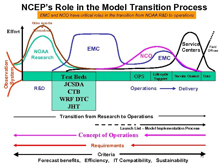 NCEP’s Role in the Model Transition Process EMC and NCO have critical roles in the transition from NOAA R&D to operations Observation System Effort Other Agencies & International NOAA Research R&D Service Centers EMC NCO OPS Test Beds JCSDA CTB WRF DTC JHT Field Offices EMC Life cycle Support Operations Service Centers User Delivery Transition from Research to Operations Launch List – Model Implementation Process Concept of Operations Requirements Criteria Forecast benefits, Efficiency, IT Compatibility, Sustainability 71
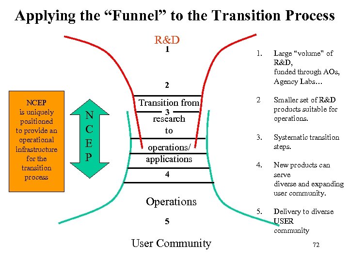 Applying the “Funnel” to the Transition Process R&D 1 1. Large “volume” of R&D, funded through AOs, Agency Labs… 2 Smaller set of R&D products suitable for operations. 3. Systematic transition steps. 4. New products can serve diverse and expanding user community. 5. Delivery to diverse USER community 2 NCEP is uniquely positioned to provide an operational infrastructure for the transition process Transition from N C E P 3 research to operations/ applications 4 Operations 5 User Community 72
 73
73
 74
74
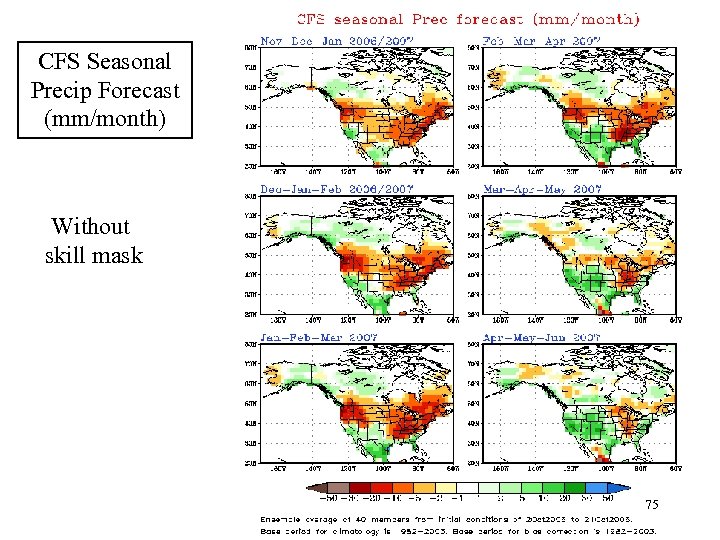 CFS Seasonal Precip Forecast (mm/month) Without skill mask 75
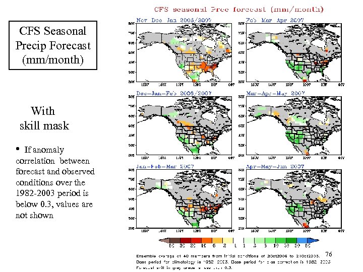 CFS Seasonal Precip Forecast (mm/month) With skill mask • If anomaly correlation between forecast and observed conditions over the 1982 -2003 period is below 0. 3, values are not shown 76
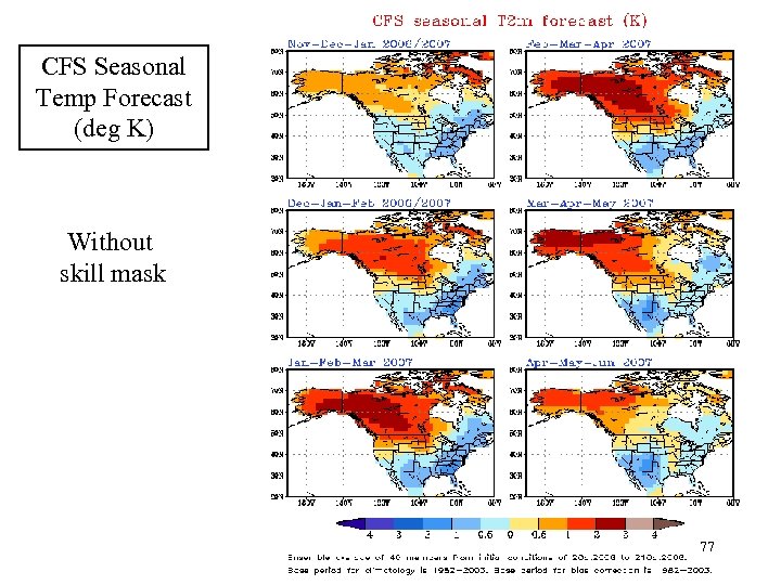 CFS Seasonal Temp Forecast (deg K) Without skill mask 77
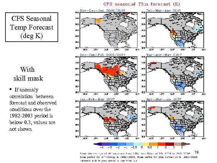 CFS Seasonal Temp Forecast (deg K) With skill mask • If anomaly correlation between forecast and observed conditions over the 1982 -2003 period is below 0. 3, values are not shown 78
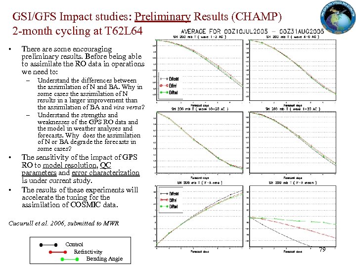 GSI/GFS Impact studies: Preliminary Results (CHAMP) 2 -month cycling at T 62 L 64 • There are some encouraging preliminary results. Before being able to assimilate the RO data in operations we need to: – – • • Understand the differences between the assimilation of N and BA. Why in some cases the assimilation of N results in a larger improvement than the assimilation of BA and visa versa? Understand the strengths and weaknesses of the GPS RO data and the model in weather analyses and forecasts. Why does the assimilation of N or BA degrade the forecasts in some cases? The sensitivity of the impact of GPS RO to model resolution, QC parameters and error characterization is under current study. The results of these experiments will accelerate the tuning for the assimilation of COSMIC data. Cucurull et al. 2006, submitted to MWR Control Refractivity Bending Angle 79
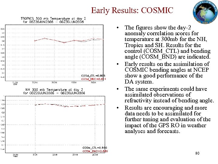 Early Results: COSMIC • The figures show the day-2 anomaly correlation scores for temperature at 300 mb for the NH, Tropics and SH. Results for the control (COSM_CTL) and bending angle (COSM_BND) are indicated. • Early results on the assimilation of COSMIC bending angles at NCEP show a good performance of the DA system. • The same experiments could have assimilated observations of refractivity instead of bending angle. • Results are encouraging and more data needs to be assimilated for further tuning and evaluation of the impact of the GPS RO in weather analyses and forecasts. 80
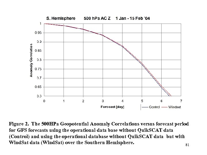 Figure 2. The 500 HPa Geopotential Anomaly Correlations versus forecast period for GFS forecasts using the operational data base without Quik. SCAT data (Control) and using the operational database without Quik. SCAT data but with Wind. Sat data (Wind. Sat) over the Southern Hemisphere. 81
 82
82


