

c4d6e4e035204b76b4b976cadd6672ba.ppt
- Количество слайдов: 23
 National Presidency Undersecretariat for Water Resources National Institute on Waters Hydrological Warning System
 De La Plata River Basin - Continental Location Southamerica
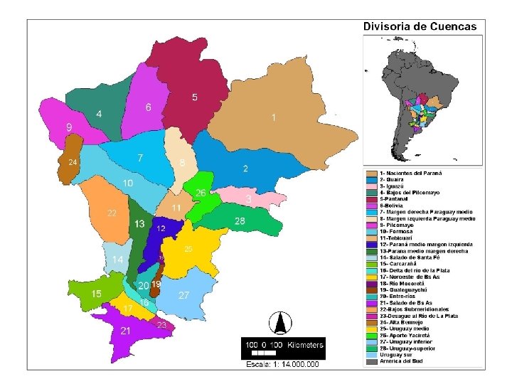
 DEL PLATA BASIN HYDROGRAPHY MAPA 00 -HIDROGRAFÍA
 De La Plata River Basin – Description – Economic Relevance Description: Approximate Extension: ~ 3, 200, 000 km 2 5 countries comprised: Argentina (downstream) Bolivia Brazil (upstream) Paraguay Uruguay Main Rivers: Paraná, Paraguay, Uruguay, Iguazú, Pilcomayo, and Bermejo. Economic Relevance: Population: ~ 100, 000 inhabitants. 80% of the GNP’s of the five countries is produced in the Basin. More than 60 hydropower dams are built in its rivers, supplying 80% of the regional demand. Its rivers are partially navigable by river barge convoys. The Paraguay- Paraná waterway is being implemented.
 Hydrological Warning System - Goals Permanent basin condition control. Anticipation of flood events or very sharp low water situations as early as possible. Regularly hydrologic forecasts in each main gauge station.
 Hydrological Warning System - Activities Meteorological, hydrometric and field data reception. Database development and update. Hydrological and Hydrodynamic Modeling. Data processing and GIS applications. Satellital images processing. Forecasting and Hydrological Warning Service
 Hydrological Warning System – Nomal Conditions Products Daily reports containing hydrometeorological information. Normal Conditions Two weekly reports on the basin’s hydrometeorological conditions and forecasts. Basin data processing for users requirements.
 Hydrological Warning System – Emergency Products Early warning reports on risk conditions in the Basin. Daily reports describing the situation and presenting short, medium and long-term prospects. Emergency Forecasts of maximum river stages indicating the probable number of days at risk. Specials reports of prevent risk according with user needs.
/INPE/MCT. SISTEMA METEOROLÓGICO") Information Sources BRASIL CENTRO de PREDICAO de TEMPO E ESTUDOS CLIMÁTICOS (CPTEC)/INPE/MCT. SISTEMA METEOROLÓGICO DEL ESTADO DE PARANÁ (SIMEPAR) PARAGUAY ADMINISTRACIÓN NACIONAL DE NAVEGACIÓN Y PUERTOS (A. N. N. P. ). URUGUAY DIRECCIÓN NACIONAL DE HIDROGRAFÍA (D. N. H). ARGENTINA BINATIONAL ENTITIES: ENTE BINACIONAL YACYRETÁ. COMISIÓN TÉCNIA MIXTA DE SALTO GRANDE. COMISIÓN MIXTA ARGENTINO-PARAGUAYA DEL RÍO PARANÁ. NATIONAL INTSTITUTIONS: SERVICIO METEOROLÓGICO NACIONAL. PREFECTURA NAVAL ARGENTINA. COMISION NACIONAL DE APLICACIONES ESPACIALES. SERVICIO DE HIDROGRAFÍA NAVAL. INTA - INSTITUTO DE CLIMA Y AGUA. DIRECCIÓN NACIONAL DE CONSTRUCCIONES PORTUARIAS Y VIAS NAVEGABLES.
Information Sources BRASIL CENTRO de PREDICAO de TEMPO E ESTUDOS CLIMÁTICOS (CPTEC)/INPE/MCT. SISTEMA METEOROLÓGICO DEL ESTADO DE PARANÁ (SIMEPAR) PARAGUAY ADMINISTRACIÓN NACIONAL DE NAVEGACIÓN Y PUERTOS (A. N. N. P. ). URUGUAY DIRECCIÓN NACIONAL DE HIDROGRAFÍA (D. N. H). ARGENTINA BINATIONAL ENTITIES: ENTE BINACIONAL YACYRETÁ. COMISIÓN TÉCNIA MIXTA DE SALTO GRANDE. COMISIÓN MIXTA ARGENTINO-PARAGUAYA DEL RÍO PARANÁ. NATIONAL INTSTITUTIONS: SERVICIO METEOROLÓGICO NACIONAL. PREFECTURA NAVAL ARGENTINA. COMISION NACIONAL DE APLICACIONES ESPACIALES. SERVICIO DE HIDROGRAFÍA NAVAL. INTA - INSTITUTO DE CLIMA Y AGUA. DIRECCIÓN NACIONAL DE CONSTRUCCIONES PORTUARIAS Y VIAS NAVEGABLES.
 Hydrological Warning System – Hydrometric Network in the Country
 Hydrological Warning System – International Hydrometric Net
 Hydrological Warning System – Information Flow IMPUT DATA: PROCESSING and DATA BASES FORECASTS: PRODUCTS: Evaluation Meteorologic Hydrologic Central and Province nodes Satellital Methodology USERS
 Hydrological Warning System – METEOROLOGICAL ACTIVITIES FOR HYDROLOGICAL PURPOSES • WEATHER DIAGNOSTIC Reception of SYNOP and other source data. Satellite Rainfall Estimation and Storm tracking. Spatial and temporal evolution of precipitation. • WEATHER AND CLIMATE FORECAST Weather monitoring through different atmospheric models ENSO Monitoring and large scale coupled ocean atmospheric process Daily reports and special issues.
 Hydrological Warning System – METEOROLOGICAL ACTIVITIES FOR HYDROLOGICAL PURPOSES REAL TIME PRECIPITATION DATA Source: WMO and other agencies
 Hydrological Warning System – METEOROLOGICAL ACTIVITIES FOR HYDROLOGICAL PURPOSES WEATHER FORECAST Source: NOAA, CPTEC and other agencies
 Hydrological Warning System – METEOROLOGICAL ACTIVITIES FOR HYDROLOGICAL PURPOSES CLIMATIC MONITORING AND ENSO Source: NOAA and other agencies
 Hydrological Warning System – METEOROLOGICAL ACTIVITIES FOR HYDROLOGICAL PURPOSES SATELLITE RAINFALL ESTIMATION: HYDROESTIMATOR TECHNIQUE 21/jan/2003
 Simulation and forecast models in real time. Fitted and available for the operation in real time. TIME SERIES ANALYSIS AUTOREGRESSIVE STRUCTURE WITH EXOGENOUS VARIABLES. PARAMETER ESTIMATION USING "KALMAN FILTERING” TECHNIQUE. NEURAL NETWORKS. NWSAFS NUMERICAL MODELS SACRAMENTO (SAC) MODEL (US. NATIONAL WEATHER SERVICE ). CONTINUOUS, DETERMINSTIC AND CONCEPTUAL HYDROLOGICAL MODEL. UNIFIED CONCENTRATED PARAMETERS. APPLIED TO LOWER IGUAZÚ CATCHMENT. HEC-1 CORPS OF ENGINEERS - U. S. ARMY. HYDROLOGICAL MODEL FOR SIMULATION AND FORECAST BY EVENT. RAIN/DISCHARGE MODEL AND WAVE PROPAGATION. APPLIED TO LOWER IGUAZÚ CATCHMENT AND MIDDLE URUGUAY CATCHMENT. HYDRODYNAMIC MODEL DEVELOPED BY THE APPLIED HYDRAULICS LABORATORY-INA. DYNAMIC WAVE PROPAGATION ONE-DIMENSIONAL CHANNEL NETWORK MODEL. CALIBRATED FOR PARANA RIVER FROM YACYRETÁ TO VILLA CONSTITUCIÓN.
 Paraná River at SANTA FE – Greatest Discharges Monthly Means ALERT EVACUATION
 HIS Cuenca del Plata An oportunity to improve the flow of observation data between and within countries to achieve more reliable and faster hydrological predictions So far, almost all countries have developed their own databases and web interfaces for data access. But the access offered is not in the form of a web service as defined by W 3 C: “a software system designed to support interoperable machineto-machine interaction over a network”. Instead, the interfaces were designed for human access only. Some efforts have been made to capture the data by 'scraping' the websites, but the solutions proved to be unstable and many fundamental data sources couldn't be sorted out in this way. Then, we still rely mostly on manual data entry, and many potentially valuable observations are not used. J. Borus and J. Bianchi, 13 Jun 2016
 Del Plata Basin RT Meteo-Hydrological Data Availability Brazil - ANA Paraguay - DINAC Most complete but hardest to 'scrap' Argentina - PN 'Scrapable' CDP Rain gauge FTP download Scrapable but unstable (no station. ids) J. Borus and J. Bianchi, 13 Jun 2016 Still our best option
 Some Challenges for Data Exchange in the Del Plata Basin To propagate knowledge about the web service paradigm in all countries and involved institutions, by showing what it is and its potential, and why it is important (HIS Plata demo), To enhance the interaction between data producers and users in order to arrive to specific solutions to data exchange problems (bi/multilateral cooperation projects), To divulgate the existence of international standards for observation data publishing, and interoperable data formats, To integrate the many different data sources within each country. J. Borus and J. Bianchi, 13 Jun 2016 Greetings from INA !!!!