5fe7dee82a1df6567349549f51d967b6.ppt
- Количество слайдов: 90


 Sentence, Phrase, Word: “The Importance of Transportation” 2) Power Point")
Monday, October 30 1) Sentence, Phrase, Word: “The Importance of Transportation” 2) Power Point study guide: “The Relationship Between the Physical Environment and Population/ Economic Growth” Turn in any “makeup”/ “late work” you may owe. Clear your desk of everything except a pen or pencil.
 Read the article provided to you (shown below). Highlight or underline")
Reading Directions: 1) Read the article provided to you (shown below). Highlight or underline important information as you read.
 Select the sentence from this selection that you believe to be")
Reading Directions: 2) Select the sentence from this selection that you believe to be most important; then, choose the phrase you believe to be key; and finally, identify one word that you think significant. The three selections may be from different parts (i. e. , paragraphs and sentences) of the reading. Be ready to share your selections, along with the reasons why you chose each.
 Now find a partner and discuss the following: (All participants share")
Reading Directions: 3) Now find a partner and discuss the following: (All participants share before moving on to next item) Each shares sentence with why that sentence was chosen. Each shares phrase with why that phrase was chosen. Each shares word with why that phrase was chosen.
 Debrief Questions (Discuss as Group) What were common themes?")
Reading Directions: 4) Debrief Questions (Discuss as Group) What were common themes?

GDP: Per capita income: $1. 51 trillion $43, 400 $15. 9 trillion $50, 700 Both Canada and the United States have prosperous highly developed, industrialized economies. However, what might best explain the difference in the size of the economies shown above?

GDP: $1. 51 trillion Per capita income: $43, 400 $15. 9 trillion $50, 700 Population : 316. 7 million 34. 5 million

MAIN IDEA FOR TODAY: What is the relationship between physical geography and transportation and how did it impact economic development and population growth in the United States?

DIRECTIONS: Read your heading and write/ circle a #5 at the top of your study guide. Answer/ complete the study guide as we review the following Power Point.

At the end of the 18 th century, many Europeans immigrated to North America (the United States and Canada). What was it about the physical geography of North America that attracted so many immigrants?

“Pull-Factors” that Attracted Immigrants to North America: * Free/ cheap land * Abundant natural resources * Fertile soil The land provided everything they needed to be selfsufficient! (They lived at a “subsistence level”)

However, most European immigrants choose to settle in the United States as opposed to Canada. What might best this? “Pull-Factors” that Attracted Immigrants to North America: * Free/ cheap land * Abundant natural resources * Fertile soil * ? ? NOTE: This was prior to the Industrial revolution that began in the mid-19 th century.

Canada’s climate will always limit its Which of the below did economic potential and thus its population Canada lack that growth/ settlement. convinced most European immigrants to immigrate to the United States instead of Canada prior to the Industrial Revolution? • Free/ cheap land • abundant natural resources • fertile soil • mild climate (Canada’s colder climate limited agricultural production)

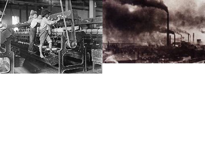
The Emergence of Factories and Mass Production of Goods The Industrial Revolution was beginning in the second half of 19 th century in North America. As a result, Americans began to rapidly migrate westward. Why would this lead to population migration?

The U. S. had abundant natural resources that emerging factories in the east needed. NOTE: Coal was the primary energy source for America’s early factories.

However, what major obstacle do you think that Americans in the east faced in migrating westward? * * *

Distance! * * *

However, once again, the U. S. had an advantage over Canada - the U. S. had an excellent natural transportation infrastructure (navigable rivers) in the eastern half of the U. S. to get the natural resources from the interior of the eastern half of the U. S. to the factories on the east coast.

America’s first major cities in the Eastern half of the U. S. developed on water ways (coastal areas and rivers) to aid in the transportation of natural resources and goods. * * * * ** *

* cto ries atio no f fa * * * Loc a nat ura tion o l re f sou rc es However, as settlers tried to push ever further westward, into the Western half of the U. S. , distance wa more problematic. Why?

RESOURCES Consumers FACTORIES Manufactured Products NO NAVIGBLE RIVERS IN THE WEST!

What does transporting goods and resources using this route do to prices of those goods ? resources factories

However, what technological development eventually allowed the U. S. to overcome this problem in the West related to distance? resources factories

RAILROADS- again, right place, right time

Railroads are important to a nation’s development because they move people and goods across the country and thus promote settlement and economic development in those areas.

Unlike in the eastern half of the United States, where most major cities developed along rivers, in the western half of the U. S. major cities developed along railroad routes.

Lets look at other modern transportation infrastructure developments that greatly aided in the United States’ ability to over come the problem of distance and thus sustain a larger, growing population. * * *

Settling the Great Lakes Region Today, the Great lakes region is densely populated and highly industrialized.

However, part of the St. Lawrence River was “unnavigable” and went through British Canada. “unnavigable”- too shallow 200 years ago, this physical feature limited economic growth and population settlement in the Great Lakes region. So how was this problem overcome?

The Erie Canal A man-made waterway in New York state that connected the Great Lakes with the Hudson River; allowed easier access to the abundant natural resources in the Great Lakes region; this stimulated economic growth and thus population growth in the region.

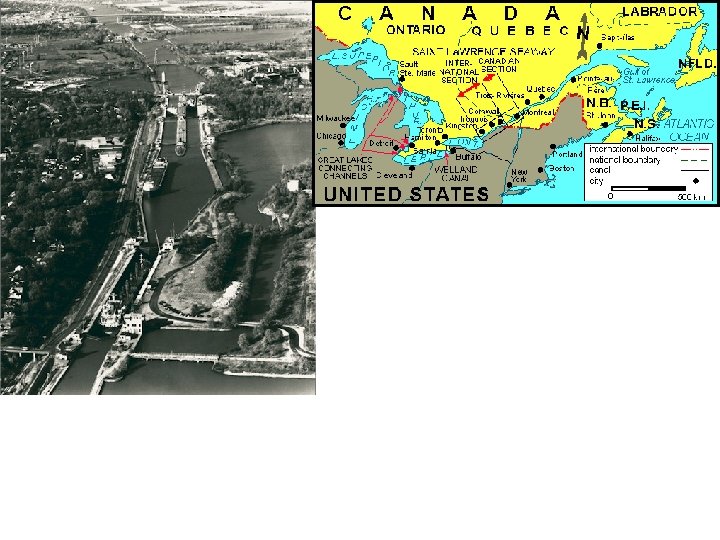
THE ST. LAWRENCE SEAWAY A joint Canadian- American transportation project that connected the Great Lakes with the Atlantic Ocean- made the St. Lawrence River navigable. Note: it made the Erie Canal lose importance.

Today, what is the main mode of commercial transportation in the U. S. ?

However, this type of transportation was used in a very limited capacity until the late 1930 and early 1940 s. Why?

Typical early 20 th century American roads

The “National Highway System” greatly increased transportation thus promoted economic development and population settlement throughout the U. S. Why is this not an option for Canada?

CONCLUSION: Population settlement and economic growth are dependent on ease of access to natural resources and transportation. Transportation, however, is impacted by physical geography. The United States’ natural and advanced transportation infrastructure networks has created more economic opportunities than in Canada. This allowed the U. S. to create a larger population and thus a larger, more powerful economy.

The End


There were two important factors, both related to physical geography, that prompted many Europeans immigrants to come to America instead of Canada prior to the Industrial Revolution in the mid 19 th century:
 Land ownership opportunities The United States had large tracts of unsettled, arable land")
1) Land ownership opportunities The United States had large tracts of unsettled, arable land that the government was either giving away or could be bought cheaply.
 Land ownership opportunities The United States had large tracts of unsettled, arable land")
1) Land ownership opportunities The United States had large tracts of unsettled, arable land that the government was either giving away or could be bought cheaply. Now, what does this imply about land ownership opportunities back in Europe at the time that would prompt many Europeans to immigrate to the U. S. ?

Prior to the Industrial Revolution, Europe had a social-economic system based on land ownership in the hands of a few (the aristocracy- “Lords, Nobles, Monarchs”. ) Only a few European elites owned land. This severely limited economic opportunities for the majority of Europeans who were landless.


What might explain why Canada does not have as highly developed of a railroad network as the U. S. ? Railroad Lines In Canada- 2010

The northern half of Canada is dominated by marsh lands and cold climate Last Ice Age Glaciers Modern Landform Shaped by Glacier Erosion

In the second half of the 19 th century, as more and more people settled the rural areas of the western frontier in the United States, . . .
 to feed a rapidly")
The United States had abundant agriculturally productive land (arable land) to feed a rapidly growing population.

Chicago in 1830 . . . cities began to grow. Chicago in 1870 Chicago in 1840 Why? Chicago today

The Emergence of Factories and Mass Production of Goods The Industrial Revolution was beginning in the second half of 19 th century in North America. (migration transformation: rural urban)

Cities became trade centers/ they connected producers and consumersnatural resources were sent to cities to make manufactured goods in factories.

However, as cities grew, what could the people who migrated to cities no longer do? In other words, what did city inhabitants need?

As cities grew, they needed to be fed!!!

What affect did this have on agricultural production in the U. S and this way of life pictured below (subsistence living)?

Impact of Rapid Urbanization Associated with the Industrial Revolution Americans farmers moved from subsistence farming to commercial farming. subsistence farming commercial farming What was it about our nation, in terms of its physical geography, that allowed us to be agriculturally productive in the years to come?
 to feed its rapidly")
The United States had abundant agriculturally productive land (arable land) to feed its rapidly growing population.

Why wasn’t this the case for Canada?

Why wasn’t this the case for Canada? Cold climate!

Why would Canada help us build the St. Lawrence Seaway?


HUMAN-ENVIRONMENT INTERACTION IN NORTH AMERICA

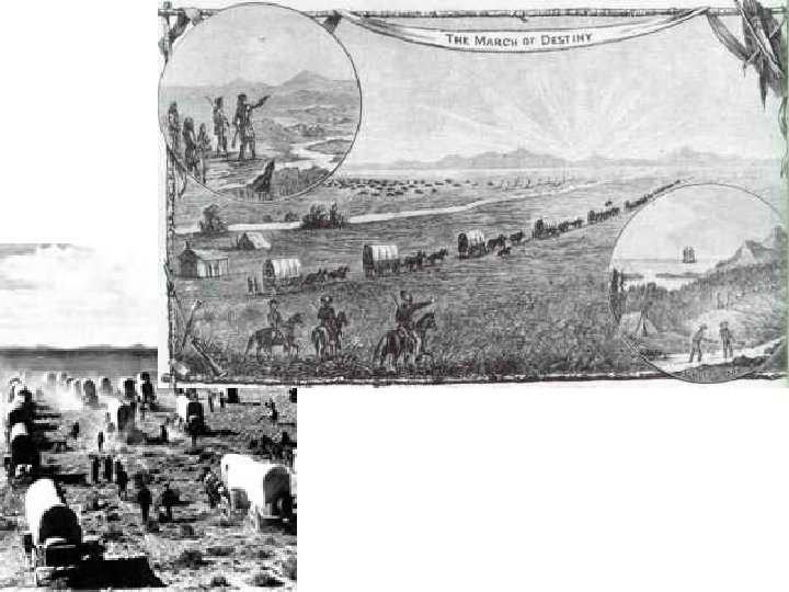
The Oklahoma Land Rush Europeans were attracted by cheap/ free land.

What “push factor” forced the first European immigrants to come to North America, the U. S. in particular?

Religious Persecution!!!!

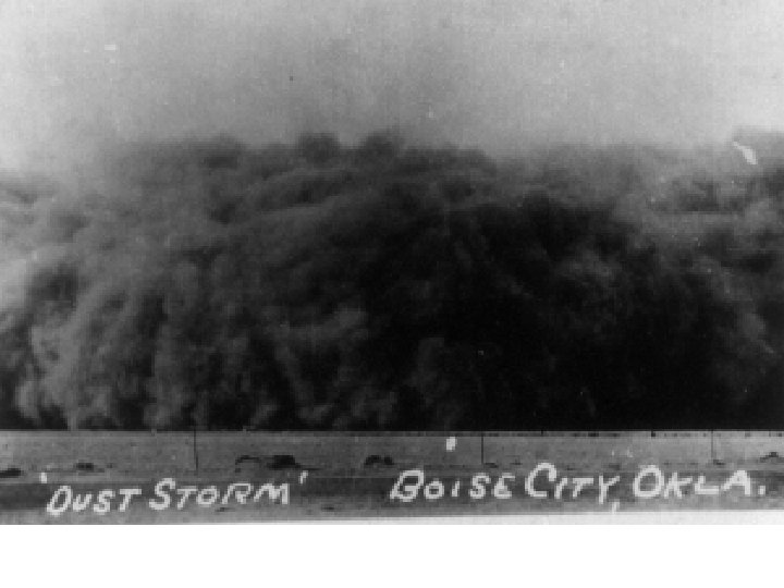
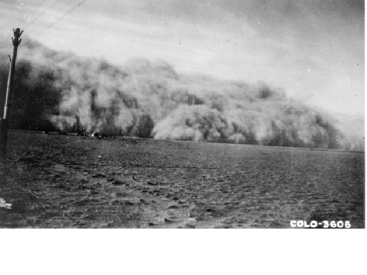
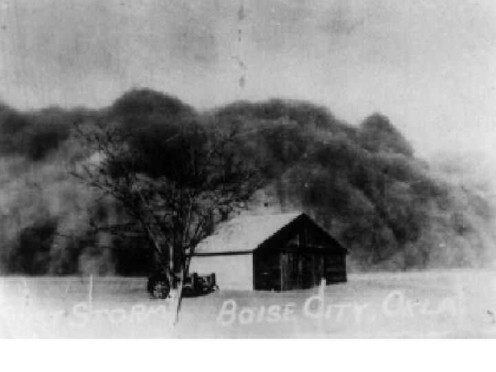
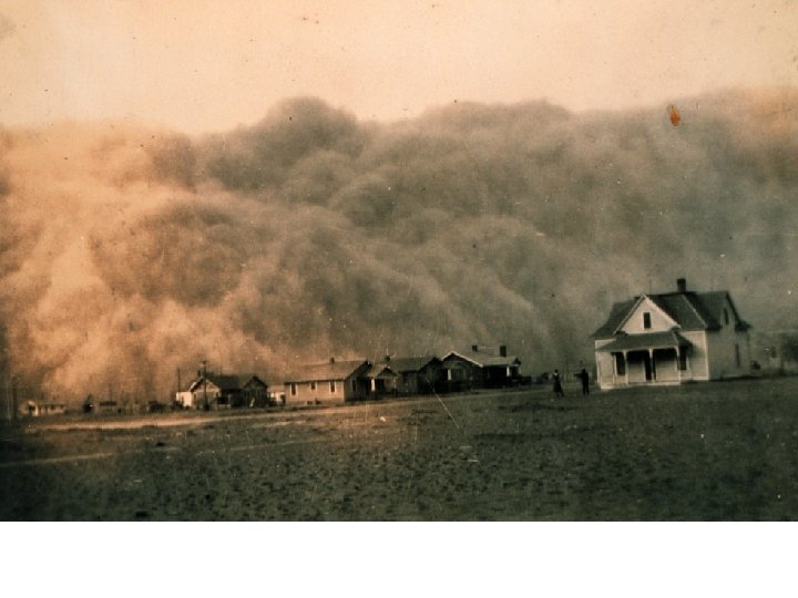
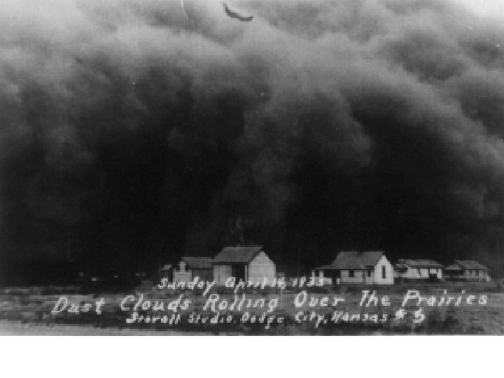
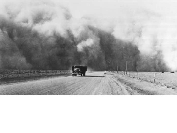
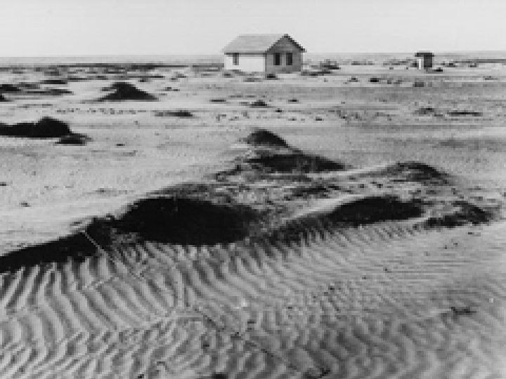
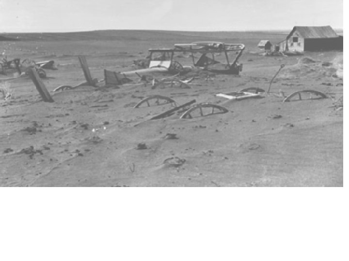
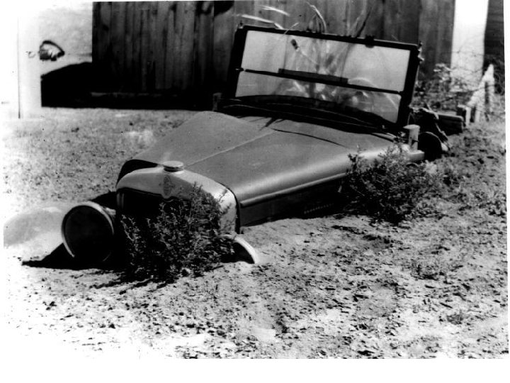
Have you ever heard “a picture speaks a thousand words”?

Describe the mood or feeling in this photo.
")
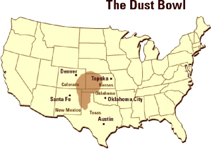
The Dust Bowl (1931 -1939)

Typical weather patterns in the summer.

Weather pattern during the 1930 s that resulted in a prolonged drought.

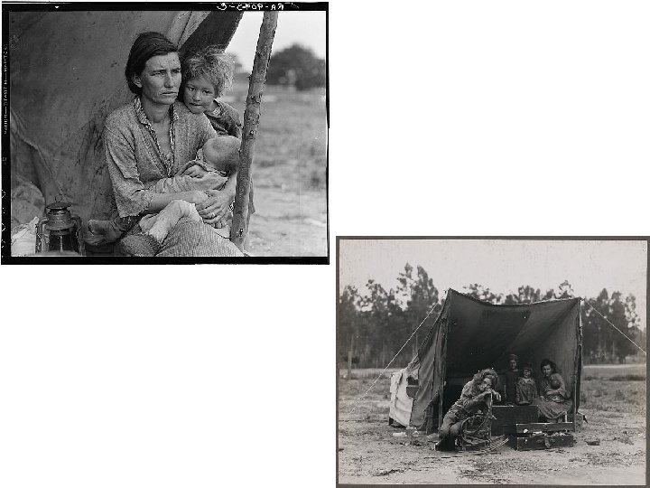
"Migrant Mother", black and white photograph by Dorthea Lange, Nipomo, California, February, 1936. Lange was concluding a month's trip photographing migratory farm labor around the state for what was then the Resettlement Administration. In 1960, Lange gave this account of the experience: I saw and approached the hungry and desperate mother, as if drawn by a magnet. I do not remember how I explained my presence or my camera to her, but I do remember she asked me no questions. I made five exposures, working closer and closer from the same direction. I did not ask her name or her history. She told me her age, that she was thirty-two. She said that they had been living on frozen vegetables from the surrounding fields, and birds that the children killed. She had just sold the tires from her car to buy food. There she sat in that lean- to tent with her children huddled around her, and seemed to know that my pictures might help her, and so she helped me. There was a sort of equality about it.


THE ERIE CANAL

3000 years agoagricultural production began in North America. * late start compared with Eastern Hemisphere.

The Salem Witch Trials

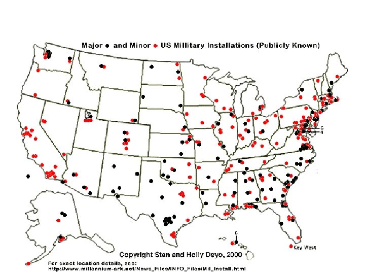
One of the major obstacles that early settlers faced in moving across North America

Siegfried Schubert of NASA's Goddard Space Flight Center, Greenbelt, Md. , and colleagues used a computer model developed with modern-era satellite data to look at the climate over the past 100 years. The study found cooler than normal tropical Pacific Ocean surface temperatures combined with warmer tropical Atlantic Ocean temperatures to create conditions in the atmosphere that turned America's breadbasket into a dust bowl from 1931 to 1939. The team's data is in this week's Science magazine. These changes in sea surface temperatures created shifts in the large-scale weather patterns and low level winds that reduced the normal supply of moisture from the Gulf of Mexico and inhibited rainfall throughout the Great Plains.
5fe7dee82a1df6567349549f51d967b6.ppt