

61a9071ed682f300453ad8f6aa852ed7.ppt
- Количество слайдов: 19
 Land Water Development Division Water Resources, Development and Management Service AQUASTAT Key water resources statistics by Karen FRENKEN International Work Session on Water Statistics, Vienna, Austria, 20 -22 June 2005
 Water resources Review of world water resources by country: ü Internal, external surface water and groundwater ü Country dependency on water from other countries ü Flows reserved by treaties ü Calculation spreadsheets with rules and guidelines for accounting water resources ü Regional overviews of the water resource situation
 Key words • Presents country-level information • Deals with renewable water resources • Concentrates on the physical assessment of internal and external renewable water resources • Presents of picture of the natural state and current situation, taking into account existing uses of water • Combines field-based approaches with modeling approaches
 • External Renewable Water resources") Renewable water resources • Internal Renewable Water Resources (IRWR) • External Renewable Water resources (ERWR) • Natural Renewable Water Resources (NRWR) • Actual Renewable Water Resources (ARWR) • Exploitable Water Resources
Renewable water resources • Internal Renewable Water Resources (IRWR) • External Renewable Water resources (ERWR) • Natural Renewable Water Resources (NRWR) • Actual Renewable Water Resources (ARWR) • Exploitable Water Resources
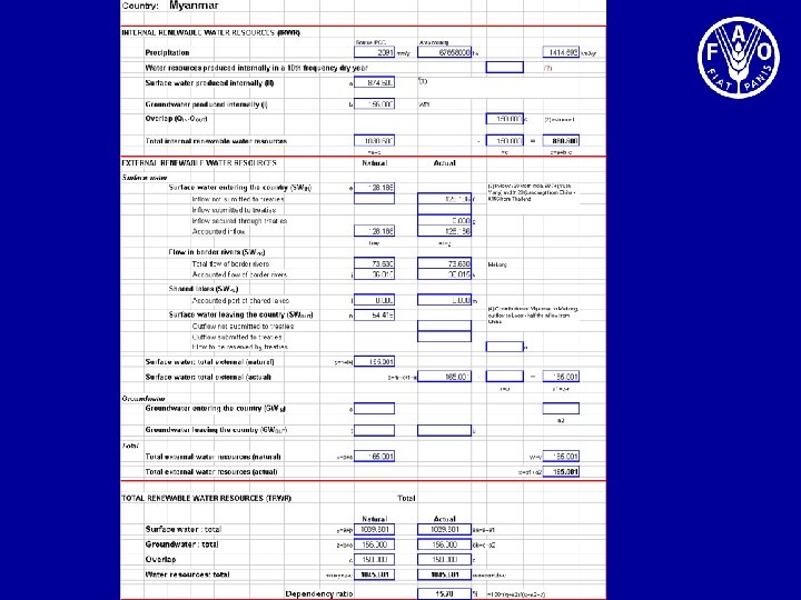
 R") Internal Renewable Water Resources IRWR = R + I – (QOUT – QIN) R = Surface runoff, generated from endogenous precipitation I = Groundwater recharge, generated from endogenous precipitation QOUT = Groundwater drainage into rivers (typically, baseflow of rivers) QIN = Seepage from rivers into aquifers A simple addition of surface water and groundwater would lead to an overestimation of the renewable water resources. (Qout – Qin), called Overlap, is the exchange between surface water and groundwater or the common part of surface water and groundwater. Humid countries: O = Very arid and coastal areas: O =
Internal Renewable Water Resources IRWR = R + I – (QOUT – QIN) R = Surface runoff, generated from endogenous precipitation I = Groundwater recharge, generated from endogenous precipitation QOUT = Groundwater drainage into rivers (typically, baseflow of rivers) QIN = Seepage from rivers into aquifers A simple addition of surface water and groundwater would lead to an overestimation of the renewable water resources. (Qout – Qin), called Overlap, is the exchange between surface water and groundwater or the common part of surface water and groundwater. Humid countries: O = Very arid and coastal areas: O =
 Internal renewable water resources in the Nile Basin
 External Renewable Water Resources ERWRNATURAL = SWIN + SWPR + SWPL + GWIN ERWRACTUAL = SW 1 IN + SW 2 IN + SWPR + SWPL – SWOUT + GWIN SW 1 IN = Surface water entering the country which is not submitted to treaties SW 2 IN = Surface water entering the country, which is secured through treaties SWPR = Accounted flow of border rivers SWPL = Accounted part of shared lakes SWOUT = Surface water leaving country, reserved by treaties for downstream countries GWIN = Groundwater entering the countries Actual ERWR may vary with time. Established rules to compute the different components of the external water resources
 Total Renewable Water Resources TRWRNATURAL = IRWR + ERWRNATURAL TRWRACTUAL = IRWR + ERWRACTUAL While IRWR can be added up, TRWR can not
x 100% IWR = SW 1 IN + SW 2 IN") Dependency ratio = IRWR/(IRWR+IWR)x 100% IWR = SW 1 IN + SW 2 IN + SWPR + SWPL + GWIN SW 1 IN = Surface water entering the country which is not submitted to treaties SW 2 IN = Surface water entering the country, which is secured through treaties SWPR = Accounted flow of border rivers SWPL = Accounted part of shared lakes GWIN = Groundwater entering the countries The dependency ratio does not consider possible allocation of water to downstream countries Indicator varies theoretically between 0 and 100 percent
Dependency ratio = IRWR/(IRWR+IWR)x 100% IWR = SW 1 IN + SW 2 IN + SWPR + SWPL + GWIN SW 1 IN = Surface water entering the country which is not submitted to treaties SW 2 IN = Surface water entering the country, which is secured through treaties SWPR = Accounted flow of border rivers SWPL = Accounted part of shared lakes GWIN = Groundwater entering the countries The dependency ratio does not consider possible allocation of water to downstream countries Indicator varies theoretically between 0 and 100 percent
 Matrix of transboundary flows
 The potential of models • Relying on country information alone does not ensure consistency between countries • A model, using available information, presents a homogenous methodology for computing the water balance across a continent • The model developed is simple and performed entirely within the GIS environment • It has been tested on Africa and will next be used on Asia • Combined use of country-based data and global water-balance modeling can enhance the overall reliability of the results
 Assessment of the results & reflections
 Country information • Critical analysis is necessary to ensure consistency between different data collected • Gathering data from different sources highlights similarities, but also contradictions • Little information available on humid Africa • Many studies done on arid climates, but access to information is sometimes restricted for strategic reasons • No consistency can be ensured at regional level on period of reference, duration, etc.
 is not perfect. Natural versus") Natural water resources • Hydrological approach (measurements, extrapolation, modeling) is not perfect. Natural versus actual; upstream versus downstream • Metadata needed on methods used, validity of results, etc. • Time reference problem (reference period, frequency of occurrence) • Spatial reference problem (maps, region, country, basin) • Water quality problem (definition, classes, changes during flow)
Natural water resources • Hydrological approach (measurements, extrapolation, modeling) is not perfect. Natural versus actual; upstream versus downstream • Metadata needed on methods used, validity of results, etc. • Time reference problem (reference period, frequency of occurrence) • Spatial reference problem (maps, region, country, basin) • Water quality problem (definition, classes, changes during flow)
 Exploitable water resources Natural resources are quantified exclusively on a hydrological basis, which is necessary. However, not all natural water is accessible. Need to quantify ‘exploitable’ or ‘manageable’ water resources as a function of: • technical-economic criteria : affordable cost of development and exploitation • Environmental criteria : exclusion of water that needs to be conserved for nature • geopolitical criteria : sharing of water between countries Minimum of consensus between the countries of each large region in the world needed in order to have water statistics that are comparable and respond better to the demands
 Secondary and non-conventional sources of water • Secondary resources refers to return of primary water into the system, thus becoming available for use again. It is the interaction between resource and use in a same area without increasing the natural resource. Example: agricultural drainage water • Wastewater reuse refers to the reuse of urban or industrial wastewater (with or without treatment), increasing the overall efficiency of use of water (extracted from primary sources) • Desalinized water refers to the production of freshwater by desalinization of brackish water or saltwater • Inter-basin water transfer, transporting water between different river basins. Examples: Highlands water project in Southern Africa, importation of water in Israel from Turkey
 Concluding remarks Adaptation of ‘water statistics’ to information needs should be well targeted. Always ask question for whom and for what use they are intended It is advisable to regionalize the efforts to improve water statistics as a function of the needs, which are far from uniform in the world
 Thank you Web site: http: //www. fao. org/ag/aquastat