

lecture_1_geodesy.ppt
- Количество слайдов: 25
 KAZAKH LEADING ACADEMY OF ARCHITECTURE AND CIVIL ENGINEERING FCTIM Lecture 1: General information about geodesy Assistant of professor Inerbayeva Daniya A.
 GEODESY OUTLINE: Ø definition and history Ø three major models Ø how are reference shapes used Ø geodetic systems
 GEODESY Ø mapping involves Ø Ø transforming positions onto flat map, Ø Ø determining locations on earth, graphically symbolizing those positions to establish a system of geographic coordinates, we first have to know the Earth’s size and shape
 GEODESY Geodesy: discipline that deals with measurement and representation of earth in a three-dimensional time varying space Ø uses spaceborne and airborne remotely sensed, and ground-based measurements
 GEODESY study of: Ø size and shape of earth Ø measurements of the position and motion of points on the earth’s surface Ø configuration and area of large portions of earth’s surface
 HISTORY OF GEODESY Ø has been around since approximately 500 BC, not taken seriously until 100 AD (Ptolemy) Ø Toscanelli (1397 -1482) famous incorrect vision of the world
 HISTORY OF GEODESY Ø notion of the earth’s gravity started to form in the late 1500 s and early 1600 s Ø mid 18 th C to present - position determined by terrestrial and astronomical means was needed for making maps
 IMPORTANCE OF GEODESY Ø geodesy has a symbiotic relationship with some other sciences
 MAJOR MODEL OF GEODESY 1. Sphere: Ø based on observations of ships going over horizon and astronomical phenomena Ø Authalic sphere – sphere with the same surface area of earth as a more regular surface called ellipsoid Ø used today for short range navigation and global distance approximations
 MAJOR MODEL OF GEODESY 2. Ellipse: Ø earth is ellipse with a slightly larger equatorial axis than polar axis (~20 km) due to spinning of earth Ø most commonly used model to calculate position on earth
 MAJOR MODEL OF GEODESY sphere ellipse
 MAJOR MODEL OF GEODESY
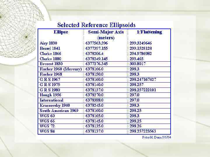
 Ø Ø at least 20 different determination of parameters for ellipsoid since 1800 geodesists use semi-major axis and flattening to identify ellipsoids
 MAJOR MODEL OF GEODESY 3. Geoid Ø surface where strength of gravity equals that at mean sea level Ø variations in rock density and topography causes deviations up to 100 m Ø irregular (geoid) vs regular (ellipsoid)
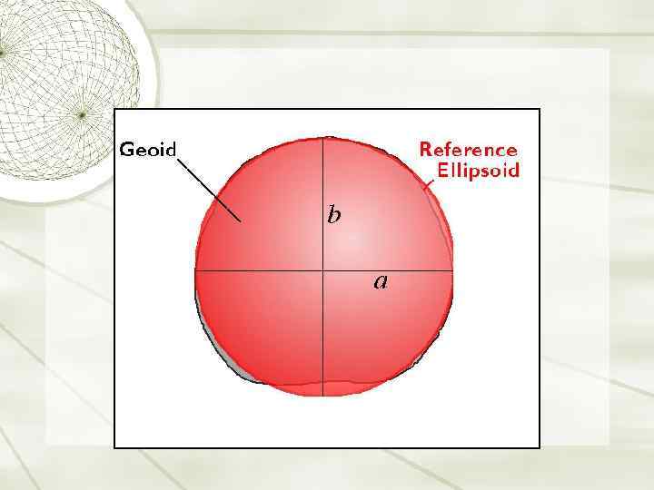
 Ø rises over continents, depressed in oceanic areas
 Ø highest point over New Guinea; lowest point, south of India
 MAJOR MODEL OF GEODESY Ø Current geoid model available in Kazakhstan Ø Kazakh gravimetric geoid model (Kaz. GGM 2010) Geoid representation from GRACE satellite gravity mission data
 MAJOR MODEL OF GEODESY Ø small scale maps: locations defined by authalic sphere Ø detailed large scale: Ø horizontal positions – ellipsoid Ø elevations – geoid surface
 GEODETIC SYSTEMS Ø Datum – any numerical or geometrical quantity which serve as a reference or base of other quantities (coordinates of points) Ø in GIS – geodetic datums define the reference system that describes the size and shape of the earth
 GEODETIC SYSTEMS Ø two types: horizontal and vertical datum Ä horizontal datum - forms the basis for the computations of horizontal control surveys in which the curvature of the earth is considered Ä vertical datum – elevations are referred
 to") HORIZONTAL DATUMS Ø may consist of: Ø Ø azimuth of a line (direction) to some other triangulation station, Ø parameters (semi-major axis and flattening) of the ellipsoid selected for the computations Ø Ø latitude and longitude of an initial point (origin), geoid separation at the origin change in any of these quantities affects every point on the datum
HORIZONTAL DATUMS Ø may consist of: Ø Ø azimuth of a line (direction) to some other triangulation station, Ø parameters (semi-major axis and flattening) of the ellipsoid selected for the computations Ø Ø latitude and longitude of an initial point (origin), geoid separation at the origin change in any of these quantities affects every point on the datum
 DATUM TRANSFORMATION Ø must perform a datum transformation to take a latitude, longitude and/or height from one system to a second system
 by Wolfgang Torge – New York 2001 2.") References: 1. Geodesy (3 rd edition) by Wolfgang Torge – New York 2001 2. Introduction to Geodesy: The History and Concepts of Modern Geodesy by James R. Smith - Wiley-Interscience (May 6, 1997)
References: 1. Geodesy (3 rd edition) by Wolfgang Torge – New York 2001 2. Introduction to Geodesy: The History and Concepts of Modern Geodesy by James R. Smith - Wiley-Interscience (May 6, 1997)