689d0d3052fb9723593a531c7f3cedb0.ppt
- Количество слайдов: 83
 Instruments and planets ESS 202
 Stress and strain z. Stress is force felt y. Tensional stress - pull y. Compression stress - push z. Strain is deformation seen y. Tensional strain - stretch y. Compressional strain - shrink
 Stress An example Strain
 Stress: Too hard to measure z. It is what we want to know z. Reveals the forces stirring up the Earth z. Useful answers we would like to know: y. How much stress does it take to break rock? y. It there enough stress in the ground for another big earthquake? z. So we measure strain (deformation) instead y. Strain can be measured by measuring motion
 Motion z. Consider an object y. A corner of a building y. A person y. A fountain pen point z. Several ways to record motion y. Displacement y. Velocity y. Acceleration
 Defining an object’s motion z. Displacement - how far has object moved? z. Velocity - how fast is object moving? z. Acceleration - how is velocity changing? z. Usually, we choose geographical directions y. North, east, up z. If we keep track of one quantity, we can calculate the other two
 Displacement, velocity, and acceleration MIT’s solar powered vehicle
 Co-ordinates z Many possible units y. Metric (mm, cm, m, km) y. English system (inches, feet, miles) y. Other (paces, degrees, furlongs, cubits) z 3 numbers required to give complete location, for example y. X, Y, and Z relative to a reference, or y. Latitude, longitude, and depth y. Forward-backward, left-right, up-down z Plus time z Usually, we choose geographical directions y. North, East, Up
 Best seismometers measure ground velocity
 Seismometers z. Some say it’s really a seismograph z. An instrument for recording the motions of the Earth’s surface through time yused to record seismic waves z. Seismogram - record of ground motion z. A suspended mass stays in place while the Earth moves back and forth under it ydue to inertia
 Simplest horizontal design Press, 18 -1 Ground moves to right
 Simplest vertical design seismometer Press, 18 -2
 Seismometer design z. Essentials y. A heavy weight y. A way to record the motion of the weight y. A spring to keep the weight away from the sides y. A pivot so weight only moves in one direction z. Luxuries y. An airtight box y. Electronics to extend frequency response y. A firm anchor for the seismometer
 Zhang Heng z In 132 Zhang invented the first seismograph (really just a seismoscope) for measuring earthquakes. z Earthquakes were significant in China at this time, not only for the destructive power which they unleashed but also because they were seen as punishment from the gods for poor governance of the country. z In his role as chief astrologer he was responsible for detecting signs of bad government that were indicated by earthquakes.
 Seismoscope z 132 AD z Balls held in dragon’s mouths were linked to a vertical pendulum z Shaking dislodged balls z Direction back to epicenter indicated by first ball released
 www. kepu. com. cn Museum of earthquakes z. Worked on March 1, 138 A. D. y. Invented by Zhang Heng y. Ball dropped from westernmost dragon’s mouth y. Days later, report arrived of earthquake 500 km to the west!
 Seismic waves have a variety of frequencies (periods) High frequency Low frequency
 Need three components to completely record motion Bolt, 3 -2
 Milne-Shaw seismometer z One of first seismometers y. Globally distributed in 1890’s z "He always spoke with a quiet Lancastrian accent, which fascinated us lads, as did his nicotine-stained, bushy moustache with a gap burned in it by numerous cigarettes. " John Milne
 Brief Milne biography z By 1895, Milne had been in Japan for 20 years, had married a Japanese woman, and appeared settled for life. z Then, a fire destroyed his home, his observatory, his library, and many of his instruments. z Disheartened, he returned with his wife to England settled on the Isle of Wight. z He persuaded the Royal Society to fund 20 earthquake seismographs around the world. The total cost was about $5000. z For 20 years, this obscure bucolic location was the world headquarters for earthquake seismology.
 1931 earthquake in England z. Milne-Shaw recording z. M 6
 US scientists in 1925 (J. B. Macelwane Archives, Saint Louis University) Jesuit priests, paper records, magnifying glass.
 State of the art tool SLU Billikins Rev. James B. Maclewane with the thirty-inch Dietricheimer globe, then state-of-the art tool for true longitudes and geocentric latitudes.
 1920’s laboratory Calculators Curve fitter
 Recording systems z. Smoked paper rotating drums z. Ink and paper rotating drums z. Photographic film rotating drums z. Analog tape z. Digital tape z. Hard drive
 Data recovery z. Driving to recording site y. Still often used z. Telephone lines y. Bad during large quakes z. Microwave transmission z. Satellite transmission z. Internet - Frame relay
 Kinds of sensors z. Permanent sites y. Anchored, wired y. Some are borehole y. Some are strong motion z. Temporary y. Wireless, or y. Local recording y. Remote sites z. Ocean bottom z. Military
 1960’s seismic station Rotating drums Three seismometers for 3 components Concrete pier Garland, 5 -2 Underground room
 Modern portable seismic station We bury seismometer and run a wire to a computer with a big hard disk, plus batteries and a big solar panel. IRIS newsletter
 Less noise in a borehole
 Strongmotion sensor
 Seismic Networks z. Regional short-period (1 -30 Hz) networks y 50 -400 instruments, vertical component only yemphasis on earthquake detection & location. z. Regional broadband (100 s - 30 Hz) networks yfewer instruments (10 -100), 3 components yemphasis on understanding bigger quakes z. Global networks yrun by many countries x. USA, France, Japan plus stations in regional nets z. Ocean bottom seismometers
 PNSN seismometers UW-USGSUO-Wash Co-op

 Uses of seismic networks z. Watching earthquakes y. Mostly long-term research y. Partly monitoring earthquake hazards z. Watching for nuclear weapons tests y. Are treaties being violated? x. Detection of explosions x. Discrimination of explosions from earthquakes • And mining blasts x. Estimating yield of explosions z. Sharing data is now a diplomatic issue
 Science & Military conflicts z. An example y. For decades (1960’s? until about 1990) Air Force operated many small seismic arrays around the world y. Finally didn’t need them, and declassified the seismograms that had been recorded y. The Generals weren’t particularly helpful x. Threw away some invaluable data rather than give it to scientists who were pestering them x. Scientists like open exchange of all data, military like to classify it as secret
 OBS’s z. Better coverage of Earth’s surface z. Curiosity y. Oceanic volcanoes y. Hot spots y. Subduction zones y. Detection of nuclear explosions z. Very expensive y. Hard to emplace y. Can’t transmit signals back
 Example - LCheapo z. Made at UC San Diego z. Can buy 100 instruments for $1, 000 z. But still need a ship to set up z. Hydrophones y. Just record water pressure, not ground motion
 Can hook up OBS’s to a cable z. Some trans-oceanic cables are in place y. Old pre-satellite phone lines y. Abandoned submarine detectors z. Example from Hawaii y. On Loihi seamount xnewest seamount in Hawaii-Emperor chain y. Has many geophysical instruments
 Various designs Not so cheap Expensive El Cheapo
 1. Drill seafloor 2. Drop into hole 3. Recover data OBS on seafloor
 NEPTUNE - initiative under way z. Extensive cabling offshore z. Seismometers z. Costs $400, 000 z. Should have been operational in 2007 y. Canadian part is being built y. US might start in 2009, run from UW
 Neptune Encircling the Juan de Fuca plate with fiber optic cable Image provided courtesy of the NEPTUNE Project (www. neptune. washington. edu) and CEV

 Planetary seismology z Best way to see layering inside of planets z Already been some seismometers on y. Moon and Mars z Many people have proposed to put more seismometers on Mars z UCLA Prof. Paige sent instruments to Mars y. To look for water and life, $170 M, 1999 y. But no parachute deployed, landed too fast, oops. y. One design team used English units (e. g. , inches, feet and pounds) while the other used metric units for a key spacecraft operation. This information was critical to the maneuvers required to place the spacecraft in the proper Mars orbit.
 Mars Polar Lander Schematic diagram (above), and incorrect guess as to location of wreckage (right).
 Mars z. Viking I and II in July and September, 1976. z. So far as I know, the seismometers only recorded wind noise. z. Scientists involved mostly want to forget experiment. z. Another failure: Net. Lander 2007 y. Victim of US-France tension
 1969 - 1972 Moon passive studies z. Apollo 11, 12, 14, 15, and 16 had seismometers, so there were up to 5 seismometer locations y. Found moonquakes x. Mostly tidally triggered x. About 1000 km deep x. Mostly less than magnitude 2 y. Saw about 2000 impacts x 0. 5 to 5000 kg meteorites x. Found a lunar core about half the radius of Earth’s core http: //cass. jsc. nasa. gov/pub/expmoon/Apollo 16/A 16_Experiments_PSE. html
 Moon Passive experiment Lander Seismometer Walter Kieffer’s page

 More lunar results z. And did active experiment y. Placed seismometers in a 90 -m long line y. Thumped the ground along the line y. Set off nine explosions up to 3. 5 km from landing site x 0. 05 to 2. 5 kg of explosives z. They found y. Very low P wave velocities (100 -300 m/s) y. About 1. 5 km layer of basalt under surface
 Explosions for seismic experiments Radio-controlled explosive Walter Kieffer’s page Mortar for active sources
 Thumper
 Lunar laser ranging z. Reflector installed on the Moon z. Finds distance to moon within 3 cm z. Confirms presence of small (< 350 km) core z. Measures that the moon is receding from the Earth 3. 8 cm/yr
 Laser beam and reflector Walter Kieffer’s page
 Geodesy - key tool z. Measuring how the ground moves over intervals from hours to years z. GPS (Global positioning satellite) z. Simultaneously measures distance from several satellites z. Originally guided cruise missiles y. Guidings cars, watching kids as well z. We can now watch the plates move with GPS
 Dashboard satellite guidance
 10 m accuracy. Easy. Now included in many phones
 GPS constellation >24 satellites, 20, 000 km up, 12 hours orbits, they broadcast a signal back to Earth.
 GPS satellite From any point on Earth, > 4 satellites will be visible Side benefit: Solves the timing problem
 GPS launch
 Using GPS Onstar car theft-prevention Ankle bracelet for felons A 40 year-old Wisconsin man has put in a strong bid for the dumbest criminal of the year after he allegedly stole a GPS tracking device used to monitor criminals on probation.
 CVHS - typical receiver Antenna Electronics Southern California
 South Pole
 Mt. Everest
 Monserrat Volcano
 Can see global plate motions with GPS
 Western drift of Turkey and Greece
 Cal. Nevada motion
 In. SAR: Latest and greatest z. Actually, US satellite not yet up z. Dedicated satellite y. Sends out a signal y. Then listens for the echo y. Scans the ground with 100 m square pixels z. Can repeat surveys every month y. Hopefully, more often soon z. So far mainly 1 component of position y. Sometimes now getting all three components
 Landers motion map Crippen
 Hector mine movement
 Ice flow in South Patagonian Icefield, Chile
 Glacier speedometer Petermann glacier in Greenland
 Subsidence of Las Vegas
 Oil withdrawal Example of Deformation Mapping in the Belridge Oil Fields (Belridge, California)
 LA rise and fall http: //www. npagroup. co. uk/insar/
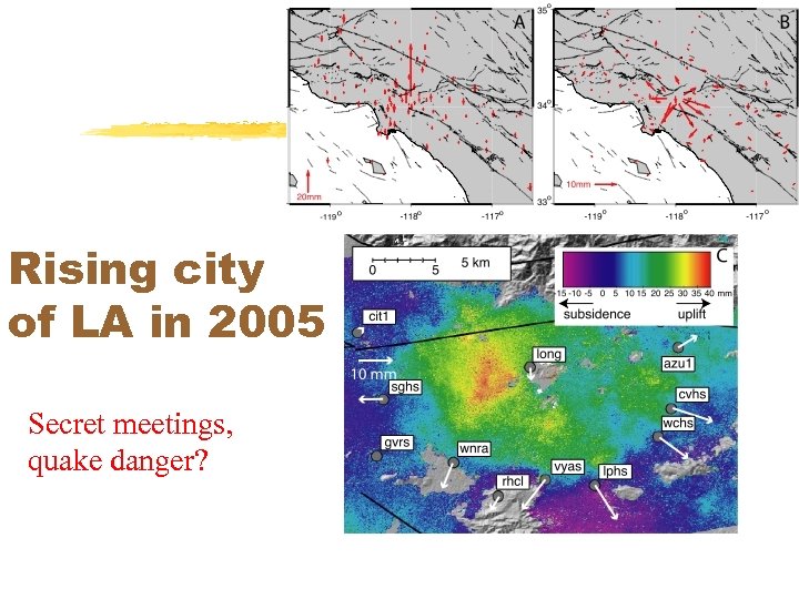 Rising city of LA in 2005 Secret meetings, quake danger?
 London subway subsidence
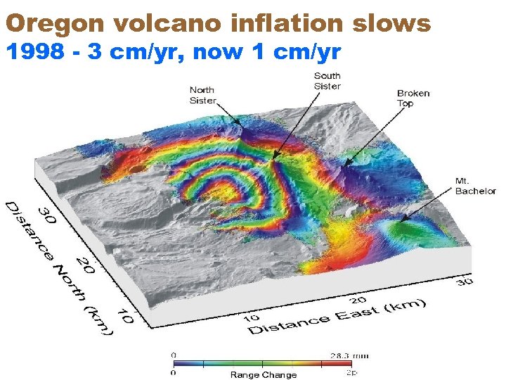 Oregon volcano inflation slows 1998 - 3 cm/yr, now 1 cm/yr
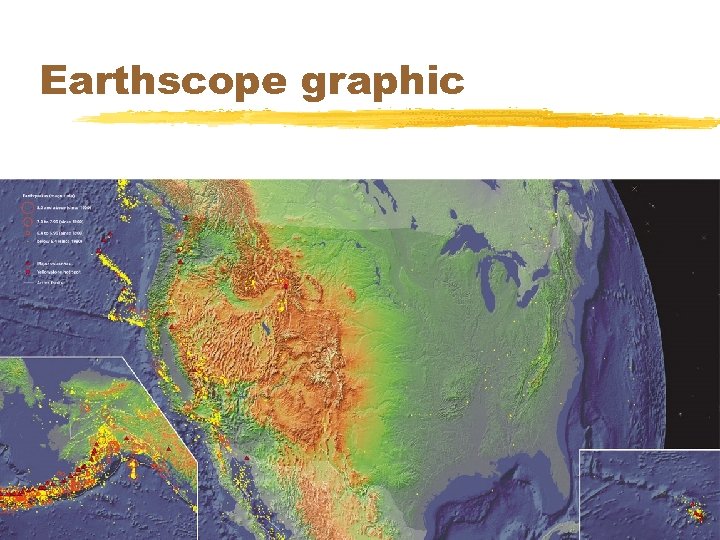
 New initiative: Earth. Scope z$400, 000 project z 10 km hole to look at San Andreas Fault y. Turned out to be 3 km z 1000 new seismometers in the US y. The wave passed us last year z 100’s of GPS and strain instruments y. In and working
 Drill to the quakes (small accident) Hole started June 1, 2003 Ran out of money, 2007
 Earthscope graphic


