

d6a8b0034b138046a49b0ab2cd6fae78.ppt
- Количество слайдов: 21
 IR Sounders Cirrus Cloud Boundaries from the Moisture Profile") Hyperspectral (i. e. , Ultraspectral) IR Sounders Cirrus Cloud Boundaries from the Moisture Profile W. L. Smith 1, 2, Jun-Li 2, and E, Weisz 2 1 Hampton University and 2 University of Wisconsin JCSDA-HFIP Workshop on Satellite Data Assimilation for Hurricane Forecasting Atlantic Oceanographic and Meteorological Laboratory (AOML) December 2 -3, 2010 My House Seaford VA Isabel Pays Unwelcome Visit To Seaford VA The 24 -36 hour track forecast was good but the surge was missed by >1 meter Can Ultraspectral Soundings Improve This!
Hyperspectral (i. e. , Ultraspectral) IR Sounders Cirrus Cloud Boundaries from the Moisture Profile W. L. Smith 1, 2, Jun-Li 2, and E, Weisz 2 1 Hampton University and 2 University of Wisconsin JCSDA-HFIP Workshop on Satellite Data Assimilation for Hurricane Forecasting Atlantic Oceanographic and Meteorological Laboratory (AOML) December 2 -3, 2010 My House Seaford VA Isabel Pays Unwelcome Visit To Seaford VA The 24 -36 hour track forecast was good but the surge was missed by >1 meter Can Ultraspectral Soundings Improve This!
 Objective of Presentation • Review ultraspectral sounding capability - today and tomorrow • Demonstrate accuracy and coverage achieved with current satellite ultraspectral sounders (AIRS and IASI) for a Hurricane situation (Isabel) • Demonstrate that use of current polar sounding data will improve Hurricane track forecasts • Discuss the need for geostationary satellite ultraspectral sounder • Describe commercial data buy venture to implement the geostationary satellite ultraspectral sounding capability
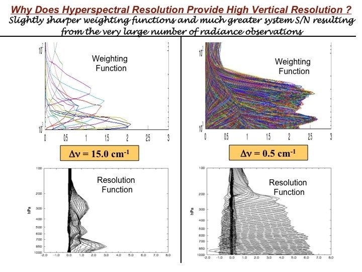
 AIRS (2002) Cr. IS (2011) MWIR LWIR GMW-GIFTS (≥") Ultraspectral Atmospheric Sounders IASI (2006) AIRS (2002) Cr. IS (2011) MWIR LWIR GMW-GIFTS (≥ 2014) / IRS (2017) • Broad Spectral Coverage • Thousands of Spectral Channels • High Spectral Resolution • High Information Content
Ultraspectral Atmospheric Sounders IASI (2006) AIRS (2002) Cr. IS (2011) MWIR LWIR GMW-GIFTS (≥ 2014) / IRS (2017) • Broad Spectral Coverage • Thousands of Spectral Channels • High Spectral Resolution • High Information Content
 Profile Information Content Number of Pieces of Information ITPR Radiosondes AIRS/IASI/Cr. IS HIRS/TOVS
 Dual Regression Technique Clear Training Data Set Isothermal Clear Training Data Set Radiances (calculated with clear FM) For 8 cloud height classes (100 -900 h. Pa) Clear trained EOF regression results Cloudy Training Data Set Radiances (calculated with cloudy FM) For 8 cloud height classes (100 -900 h. Pa) Cloud trained EOF regression results Cloud Top Altitude Final Profile (clear-trained above, cloud-trained below cloud level)
 Hurricane Isabel case study (Sept-13, 2003) Eye High") MODIS 1 km images (1705, 1710) Hurricane Isabel case study (Sept-13, 2003) Eye High Dense Cirrus Outflow
MODIS 1 km images (1705, 1710) Hurricane Isabel case study (Sept-13, 2003) Eye High Dense Cirrus Outflow
 Dual Regression AIRS Retrieval Results") Isabel (September 13, 2003, 18 UTC) Dual Regression AIRS Retrieval Results
Isabel (September 13, 2003, 18 UTC) Dual Regression AIRS Retrieval Results
 850 h. Pa Temperature and Humidity . .
 700 h. Pa Temperature and Humidity . .
 500 h. Pa Temperature and Humidity . .
 200 h. Pa Temperature and Humidity . .
 Isabel Eye Sounding
 http: /// AIRS SFOV soundings are used in WRF assimilations to improve hurricane/typhoon forecasts BT (11 m) and retrieved Temperature [K] at 500 h. Pa, 7 Sept 2008
 If AIRS SFOV soundings are included in assimilations improved track forecast can be obtained http: //cimss. ssec. wisc. edu/goes/realtime/ Tracks of ensemble mean analysis on Hurricane IKE (Analysis from 6 -8 Sept 2008) AIRS Li, J. , H. Liu, 2009: Improved hurricane track and intensity forecast usingle field-of-view advanced IR sounding measurements, Geophysical Research Letters, 36, L 11813.
 Analysis from 06") Track errors of on Hurricane IKE Li and Liu 2009 (GRL) Analysis from 06 UTC 6 to 00 UTC 8 September 2008 17
Track errors of on Hurricane IKE Li and Liu 2009 (GRL) Analysis from 06 UTC 6 to 00 UTC 8 September 2008 17
 Analysis from 06 UTC") SLP Intensity on Hurricane IKE Li and Liu 2009 (GRL) Analysis from 06 UTC 6 to 00 UTC 8 September 2008 18
SLP Intensity on Hurricane IKE Li and Liu 2009 (GRL) Analysis from 06 UTC 6 to 00 UTC 8 September 2008 18
 Need for Geostationary Ultraspectral Sounder LEO data have limitation on monitoring weather due to orbital gap and low temporal resolution. GEO can provide data anytime for weather event, unlike LEO ! High temporal resolution is unique aspect of GEO measurements 4 -d assimilation of high frequency thermodynamic soundings should improve intensity and track forecasts. 19
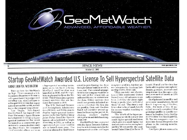
 Summary • Ultraspectral resolution radiance data improve forecasts. It has been shown that they are the single most important data input for NWP, even though < 1% of the current data is being used. • In order to assimilate “all” the information content of the radiance data, reliable sounding retrievals, which benefit from the use of all the radiance information, regardless of cloud condition or underlying surface condition. • Although IR soundings cannot be obtained below a dense overcast, they can be obtained reliably down to cloud level and below a semi-transparent or broken cloud cover. The use of soundings obtained above and in the environment of tropical storms should help improve tropical storm intensity and track forecasts. • The greatest benefit of ultraspectral resolution satellite radiance data will come with their availability from geostationary satellites. The geostationary ultraspectral sounder implementation is proceeding in China (2015 launch) and Europe (2017 launch). In the US, there is now a commercial (Geo. Met. Watch) initiative to produce as many as six imaging/sounding ultraspectral resolution sensors for geostationary Comsats positioned around the globe. The first system (GMW-1), which is based on GIFTS technology, is planned to be launched by 2015. Data would be obtained by NOAA under a data buy contract.