

e3294886654d173c81ce84fa62a3e2d0.ppt
- Количество слайдов: 68
 GEOGRAPHY PROJECT ---San Joaquin River & Related Projects
 Content • Introduction • Why people need to modify the San Joaquin River (Problems of the River) • How do they modify the river • The pros and cons of Modifying the river
 Let’s find out the location of San Joaquin River !!! The southern two-thirds of the Central Valley regional aquifer system, which covers over 13, 500 square miles and extends from just south of the Delta to just south of Bakersfield, is referred to as the San Joaquin Valley Basin
 It generally flows towards the northwest through central California and confluences the Sacramento River shortly before entering the Suisun Bay, near Oakland. The river 560 km in length, is part of an extensive irrigation and power project that has created a rich agricultural region in the semiarid San Joaquin Valley
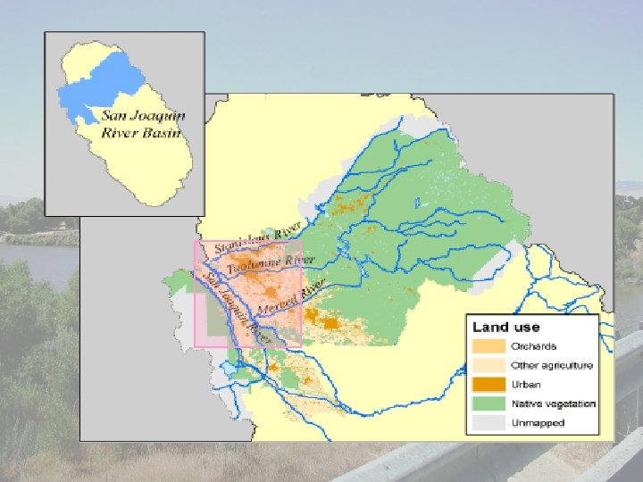
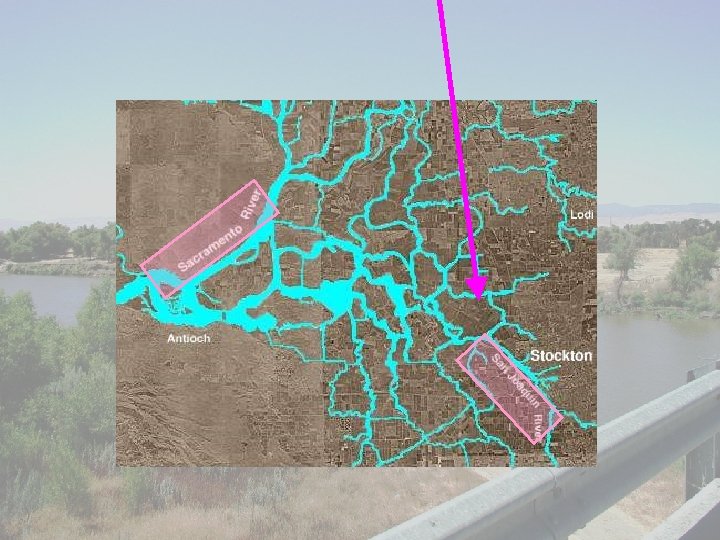
 Photo of the San Joaquin River
 Lower course Upper course
 San Joaquin Gorge at Squaw's Leap Lost Lake Park
 More about the San Joaquin River The San Joaquin River is one of the largest rivers in the state of California. It originates high on the western slopes of the Sierra Nevada, in the Ansel Adams Wilderness near Mammoth Mountain. The San Joaquin River drains most of the area from the southern border of Yosemite, south to Kings Canyon National Park, making it the second largest river drainage in the state. Only the Sacramento River is larger.
 The San Joaquin River's tributaries include the Stanislaus River, Tuolumne River, Merced River, Calveras River and Mokelumne River. They are perhaps the most heavily dammed and diverted rivers in the world. The river flows west to the trough of the Central Valley, where it is joined by the Sierra's other great rivers and then flows north to the Sacramento-San Joaquin Delta and then San Francisco Bay. Water from the river is used to irrigate 1, 500 square miles of productive farmland on the east side of the Central Valley where 200 kinds of produce are raised from oranges to cotton.
 However due to water consumption which lets only 5% of historic levels into the riverbed, in most recent years the river doesn't reach its mouth but runs dry about 37 miles below Friant Dam. The Stockton Deep Water Channel makes the lower reach of the river navigable for ocean freighters as far inland as Stockton. However, sedimentation, particularly that caused by hydraulic mining has greatly reduced the San Joaquin River system's navigability
 Why people need to modify the San Joaquin River? ? ?
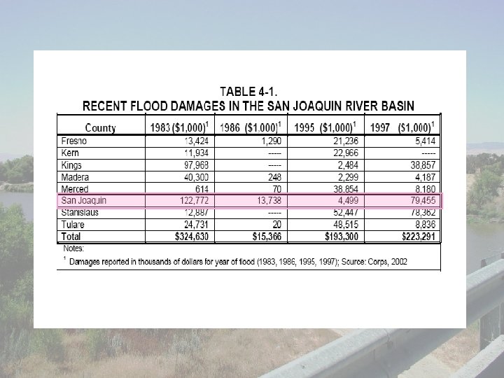
 Flooding The Sacramento River watershed receives two -thirds to three-quarters of northern California's precipitation though it only has one-third to one-quarter of the land. The San Joaquin River watershed occupies two-thirds to three-quarter of northern California's land, but only collects one-third to one-quarter of the precipitation. The Sacramento Valley suffers from floods, and floods and droughts alternately afflict San Joaquin.
") Agriculture The rainfall decreases from north to the south, high rainfall (over 1250 mm) in the north (near Sacramento River), but little rainfall (below 250 mm) in the south (San Joaquin River). More than three-fourths of the rainfall coming in a 5 -month period from December through April. Thus, the south of California is dry and not suitable for farming and growing fruits. So, irrigation water is needed to be transferred from the north to the south.
Agriculture The rainfall decreases from north to the south, high rainfall (over 1250 mm) in the north (near Sacramento River), but little rainfall (below 250 mm) in the south (San Joaquin River). More than three-fourths of the rainfall coming in a 5 -month period from December through April. Thus, the south of California is dry and not suitable for farming and growing fruits. So, irrigation water is needed to be transferred from the north to the south.
 Agriculture in the Central Valley Basin has developed through three overlapping stages: cattle ranching in the early days, followed by dry farming of small grains, and finally specialized and intensified irrigation farming of today. Although there were earlier settlements in the Central Valley, the real development of the area began in 1849, after the discovery of gold, as people came to the mining regions of the Sierra Nevada. The demand for food and fiber occasioned by this influx gave impetus to the great agricultural development of the valley.
 Cattle ranching as a major activity was brought to a sudden end by the disastrous drought of 1863 -1864, which resulted in the loss of practically all the cattle in California. This factor, plus growth of population, increased cost of land, and development of the railroads after 1869, made grain production first in agricultural importance. Dry farming of wheat and barley continued to expand until the latter part of the century, then declined as other grain regions were developed. Meanwhile, irrigation farming developed to the dominant position it now occupies.
 Salinization As more than three-fourths of the rainfall coming in a 5 -month period from December through April, the condition produces seasonal floods and droughts with heavy winter and spring runoffs, leaving a shortage of water in the summer and autumn when it is most needed for irrigation. Because maturing crops need water at a time of year when natural streamflow is lowest, many farmers resorted to irrigating by pumping from wells. Also, the primary source of flow in the San Joaquin River is groundwater.
 As irrigated agriculture expanded, the water pumped from the ground greatly exceeded the natural recharge by rainfall and streamflows. Thus, hundreds of thousands of acres developed for irrigation in the southern part of the valley burdened a rapidly diminishing supply with an increasing demand for water. In addition, diverting streamflows to irrigation and lowering ground-water levels by pumping further reduced the low summer flows of the rivers.
 As a result, salt water from San Francisco Bay began encroaching upon crop lands in the Sacramento-San Joaquin Delta, endangering another large producing area as well as inhibiting industrial development. Agricultural development also has affected the semi-confined zone. Increased rates of recharge resulting from percolation of irrigation water, combined with the rapid post-1967 decrease in pumping, caused a rise in the height of the water table over much of the western valley.
 Accumulating salts have been persistent problems along the west side and in parts of the east side of the San Joaquin River region for more than a century The soils on the west side of the region are derived from marine sediments and are high in salts and trace elements. Irrigation of these soils has mobilized these compounds and facilitated their movement into the shallow groundwater. Much of this irrigation has been with imported water containing salts, resulting in rising groundwater and increasing soil salinity.
 Therefore, salinity control, especially in the Sacramento-San Joaquin River Delta, became a major concern for northern California water users, and a major component of the California State Water Project. The Delta frequently experienced salinity intrusion, which caused problems for Antioch and Pittsburg. Unless water flowed past Antioch at a minimum of 3, 300 cfs, salt water from San Francisco Bay moved into Suisun Bay and the Delta during high tide, making the water unusable for crops and industry
 Between 1919 and 1924, the salt water in Suisun Bay allowed sufficient growth of teredo, a wood-boring, salt-water worm, to destroy $25 million of the bay's wharves and pilings. In 1924, the water reached its lowest recorded stream flow. The maximum salt water content at Pittsburg reached 65 percent. In 1926, Pittsburg and Antioch stopped using water from Suisun Bay for crops and industry. Both communities had used the bay water since the middle of the nineteenth century. In 1930, the state water plan called for construction of a 420 foot dam at Kennett to maintain a regular flow to Antioch, keeping salt water out of Suisun Bay.
 Groundwater overdraft Groundwater in the San Joaquin Valley has been heavily developed by pumping, largely for crop irrigation. Pumping has caused depressions to form as a result of subsidence and has altered regional groundwater flow patterns, recharge, and discharge. Annual groundwater pumping in the San Joaquin River region may often exceed estimates of perennial yield. All the sub basins within the San Joaquin River region have experienced some overdraft
 Land subsidence in the San Joaquin Valley has occurred mostly in areas that are confined by the Corcoran Clay, where pressure changes caused by groundwater pumping promote greater compressive stress than in the unconfined zone. The maximum land subsidence levels recorded in the Central Valley occurred within Fresno County. Land subsidence levels of as great as 30 feet have been measured in parts of northwestern Fresno County
 How do the people modify the San Joaquin River? ? ?
 Projects related to the San Joaquin River - Central Valley Project, 1937 - San Joaquin Valley Drainage Program, 1984 - San Joaquin Valley Drainage Implementation Program , 1991 ……etc The followings will only concentrate on the CVP
 Central Valley Basin The Central Valley Basin is comprised of two river basins, the Sacramento and San Joaquin River Basins. The combined basin, over 500 miles long and averaging 120 miles wide, covers more than one-third of the State of California. Except for a small opening on the western edge, the basin is entirely surrounded by mountains. The Cascade range to the north, and the Sierra Nevada to the east, rise more than 14, 000 feet from the valley floor, while the coastal range to the west rises some 6, 000 feet, separating the valley from the Pacific Ocean.
 The valley floor, covering one-third of the Central Valley Basin, is about 400 miles long and averages 45 miles in width, and covers 15, 000 acres, an area about the size of England. The Central Valley Basin has two major river systems, the Sacramento, and the San Joaquin. The San Joaquin Valley is divided into two subbasins. The northern portion of the valley is drained by the San Joaquin River that flows north until it meets with the Sacramento River at the Sacramento-San Joaquin Delta.
 A number of major tributaries drain the Sierra Nevada to the east and flow into the San Joaquin River. These tributaries include the Fresno, Chowchilla, Stanislaus, Merced, and Tuolumne Rivers. The Calaveras, Mokelumne, and Cosumnes Rivers drain directly into the Delta. The waters of the Sacramento and San Joaquin Rivers and their tributaries combine at the Sacramento-San Joaquin Delta, southwest of Sacramento, before flowing out to the Pacific Ocean through San Francisco Bay.
 The Central Valley Project -The American River Division -The Delta Division -The East Side Division -The Pit River Division -The Sacramento River Division -The San Felipe Division -The Friant Division -The Shasta Division -The Trinity River Division -The West San Joaquin Division
 Information about the Central Valley Project The Central Valley Project facilites include reservoirs on the Trinity, Sacramento, American, Stanislaus, and San Joaquin Rivers. Water from Trinity River is stored and re-regulated in Clair Engle Lake, Lewiston Lake, and Whiskeytown Reservoir, and diverted through a system of tunnels and power plants into the Sacramento River for the Central Valley. The Sacramento River carries water to the Sacramento-San Joaquin Delta
 The Central Valley Project is a complex operation of interrelated divisions. Shasta Dam, at one time considered the key to the Central Valley Project, acts as a flood control dam for the Sacramento River. Shasta Lake stores water for controlled releases downstream. The Trinity River Division diverts surplus water from the Trinity River, in the Klamath River Basin, into the Sacramento River. Water from the Trinity River Division enters the Sacramento at Keswick Reservoir in the Shasta Division.
 Downstream from Shasta Division, the Sacramento River Division supplies Sacramento River water to Tehama, Glenn, Colusa, and Yolo Counties for irrigation. Releases from Shasta Division help control salinity in the Delta Division.
 The Delta Division is the hub around which the Central Valley Project rotates. This Division contains the facilities for transporting water from the Sacramento River to the San Joaquin Valley and to farm land in the Delta Division The Delta Cross Channel diverts water from the Sacramento River to the Tracy Pumping Plant, the Contra Costa Pumping Plants, and the intakes of the Contra Costa and Delta-Mendota Canals, sending the much needed water south into the San Joaquin Valley
 Flood Control Flood operations at Friant Dam are based on anticipated precipitation and snowmelt runoff and the operations of upstream reservoirs. Flood releases from Friant Dam are maintained, when possible, at levels that could be safely conveyed through the San Joaquin River and Eastside Bypass. Generally, flood operations target releases at or below 8, 000 cfs downstream from Friant Dam.
 Major storms during the past two decades have demonstrated that Friant Dam, among many other Central Valley dams, may not provide the level of flood protection that was intended at the time the flood management system was designed. January 1997 flood flows of nearly 60, 000 cfs from Friant Dam resulted in levee failures and extensive downstream flooding.
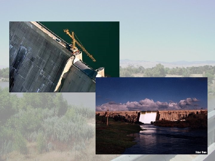
 Building dams along the river Friant Dam, just northeast of Fresno, was built between 1939 and 1947 to help sustain crops on the east side of the Valley. Weather was unpredictable, and water supplies from underground basins were dwindling. Friant Dam ensures a steady flow, capturing and diverting most of the river's water to irrigate 1 million acres of farmland. The cranes helped replace the floodgates in February 1998
 Friant Dam
 Water diversion scheme As there is flooding in the Sacramento River and drought in the San Joaquin River, water is diverted from the North to the South by building irrigation canals and aqueducts. Three-fourths of annual rainfall and snow mainly falls in the north. As a result, spring melt water is diverted to dams for summer (dry season) consumption
 Desalinization The Department of Water Resources provide technical assistance concerning desalination and advanced treatment of brackish agricultural wastewaters – including process selection, economic factors, operations and maintenance, environmental requirements, and pilot treatment studies. The recharge basin technique can also be used.
 Recharge basin technique is used to transfer surface water to spare capacity in the ground water. Pipes and the aqueducts in the San Joaquin River transfer water to the recharge basin lake. Later, water from the recharge basin percolates to the aquifer. This helps the underground water table rise or stop falling. Farmers can dig wells to get the underground water for irrigation.
 Protection of natural habitats Water deliveries from the Delta have been curtailed in recent years to help protect threatened and endangered fish populations and their habitat. However, while pumping curtailments and other actions in the Delta have been beneficial to fish, they often have adverse impacts on cities, farms, and businesses that depend on water supplies pumped from or through the Delta.
 pros and cons The
 PROS 1 Water Supply California Aqueduct provide water storage and delivery ~ Its supply comes mainly from rainfall, snowmelt runoff, and excess flows in the Delta during wet years. Water is delivered to Northern California, the San Francisco Bay area, the Central Coast, San Joaquin Valley, and Southern California. The water supplements surface and groundwater resources.
 2 Hydroelectricity reduce cost ~ immune to price increases for fossil fuels such as oil, natural gas or coal, and do not require imported fuel. Hydroelectric plants tend to have longer lives than fuel-fired generation, with some plants now in service having been built 50 to 100 years ago. Labour cost also tends to be low since plants are generally heavily automated and have few personnel on site during normal operation.
 clean ~ small emissions of carbon dioxide and methane due to reservoir emissions, and emit no sulfur dioxide, nitrogen oxides, dust, or other pollutants associated with combustion. building of dams ~ excellent leisure facilities for water sports, and become tourist attractions. Multi-use dams installed for irrigation, flood control, or recreation, may have a hydroelectric plant added with relatively low construction cost, providing a useful revenue stream to offset the cost of dam operation.
 3 Fish and Wildlife ~ recognizing the interactions of species within larger biotic communities, thus increasing the chances of survival for all member species; lessening the need to list additional species living in the same biological communities; saving money and effort expended in separate consultations over issues affecting each species; lessening the probability that some factor critical to recovery will be missed by too narrow a view;
 and, decreasing disruption to economic activities that might result from the more protracted single-species recovery efforts in an area with numerous threatened and endangered species. ~ restricting pumping schedules, fish hatcheries, fish screens and passages, mitigation agreements, fish surveys and monitoring, a fish salvage facility, and habitat restoration, are some of the mechanisms for fish and wildlife protection. The projects are also operated to meet instream flow requirements in the Feather River, the Sacramento River, and Delta channels.
 4 Water Quality ~ Central Valley Project, in cooperation with the State Water Project, is operated to limit salinity intrusion into the Sacramento-San Joaquin Delta and Suisun Marsh. This is accomplished by supplementing freshwater outflows to the ocean and limiting water exports from the Delta during specific times of the year.
 5 Uses of Project Water In 1990, on 837, 079 acres irrigated by the Friant Division, growers gathered $1. 9 billion in revenue from more than 90 varieties of crops. Fruits alone provided a $1. 3 billion contribution to that total.
 6 Flood Control Friant Dam on the San Joaquin River played a key role during central California's unprecedented 1997 floods. Friant Dam has Flood Control Storage space in the reservoir during the fall and winter months. The amount of flood control storage space is dictated from a U. S. Army Corps of Engineers Reservoir Regulation Manual.
 7 Recreation Shasta Dam and reservoir are features of the Central Valley Project - Shasta/Trinity Divisions. Recreation at the reservoir is managed by the U. S. Forest Service under agreement with the Bureau of Reclamation, Northern California Area Office. Created by a dam across the Sacramento River, Shasta Reservoir is the largest reservoir in California with 370 miles of shoreline. Located 12 miles north of Redding, the reservoir provides excellent year-round bank or boat fishing.
 8 Alleviate flooding in the North Delta, reduce reverse flows in the lower San Joaquin River, improve water quality, reduce fishery impacts, and improve State Water Project flexibility and water supply reliability.
 CONS 1 Stream flow ~ Damming a river and altering its flow pattern generates a number of physical and biological impacts. The disruption of a river’s flow obstructs its’ natural current and affects the water’s habitat. Sediment flow, which is normally carried down the river by the current.
 When trapped by a dam, the sediment is held in the reservoir and settles to the bottom while clear water containing very little sediment is released down the river. Over time, the easily erodable material from the riverbed is carried away with no sediment being deposited to replace it. This leaves a rocky streambed, resulting in a poorer habitat for aquatic fauna
 Problems of irrigation A. Salinisation refers to the build-up of salts at or near the surface of the soil. This is a common problem in the San Joaquin Valley. There is a intense competition for water from agricultural, urban and industrial users, so the problem of overuse of water is common. The problem is serious in the San Joaquin Valley. Too much water is put in the farmland. When it evaporates, small amounts of salt will be left behind. If the builds up, the soil becomes saline and is no good for farming. As a result, the productivity of farms falls.
 B. Disturbance to aquatic lives Large amount of water is pumped out from the rivers for irrigation. As a result, the water level recedes. Also, the construction f dams across rivers affect the flow of the water. All these affect the fish and other aquatic lives living in the rivers. The population of some fish species like salmon is declining.
 Because of dredging and dam building, the project has taken a toll on the environment. Much of the wildlife and riparian habitat in the Sacramento-San Joaquin Delta and Central Valley has been destroyed. Salmon (especially Chinook salmon) have been adversely impacted because they cannot reach upstream spawning grounds due to dams and water diversions.
 Pumping large amount of river water for irrigation The level of river water recedes. Construction of dams The flow of river water is affected. The population of fish and other aquatic lives declines
 C. Insufficient supply of water in other places In the northern part if the San Joaquin Valley, the amount of water is very low because too much water is taken out of the San Joaquin Valley. Farmers in this area often complain that they do not have enough water for their fields. But it is really no news that there are enormous environmental problems confronting the San Joaquin Valley ---
 too much or too little water, water of the wrong kind and in the wrong place, too much use of pesticides, herbicides, and excessively heavy machinery, land becoming compacted, too salty for cropping, fertile soils going irretrievably under asphalt. Nor is it news that there is an economic crisis building on the highly specialized business that is modern California farming. Shrinking export demand, slumping commodity prices, the nose-dive in land values, and overextended farm indebtedness dating from the euphoria of the seventies are taking their toll.
 Pinched Kern County farmers, including some of the biggest operators, are even considering selling a part of their allocations of state water to the thirsty Metropolitan Water District of southern California, a move that could make them as much water brokers as farmers. These and other matters undeniably cry out for attention. Aquatic, terrestrial, and riparian communities have been greatly diminished by the extensive water, agricultural, and urban development in the San Joaquin basin.
 D. Resettlement of local people The construction of the project will displace a considerable number of people. They may find difficult to adapt to a new living environment. In terms of farming, the new environment may be worse than before that the output will decrease in a large extent.
 E. High cost paid by the Government The Government needs to spend a large sum of money on the construction of the Central Valley Project, maintenance of the dams, compensation to the local people that affected by the project.
 By: Helen Nicole Mandy Karen