5d09bb90a21b4e09b9ca12d986250baf.ppt
- Количество слайдов: 25
 Geography 911: Neo. Geography GIS 2. 0 and Software Toolkits Joshua S. Campbell – 23 February 2010
 Biography Ph. D Candidate Built the Cyberinfrastructure system at KARS/KBS GIS 2. 0: Definition, Implications for Humanitarian Information Management, Disruptive Strategy for Implementation 4 th year of the project Web mapping core, metadata portal, dynamic HTML redesign Humanitarian Intelligence Analyst Humanitarian Information Unit (HIU), U. S. Department of State
 Neo. Geography Does it really exist? Began as an expression of Web 2. 0 applied to maps AJAX, Java. Script APIs, RSS Craigslist mashup / Chicago Crime Maps * Democratization of geographic tools Web Developers discovered Geography… What about Geographers discovering the Web?
 What is Web 2. 0? “a transformative force that’s compelling companies across all industries towards a new way of doing business characterized by harnessing collective intelligence, openness, and network effects” --Tim O’Reilly
 What is a GIS? A digital representation of the earth, structured to support analysis (Dobson, 2007) Automated systems for the collection, storage, retrieval, analysis, and display of spatial data (Clarke, 1995) Should also include dissemination Composed on software, hardware, and people
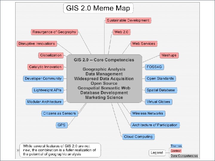
 GIS 2. 0: A Reformulation Free and Open Source Software Web 2. 0 philosophy collective intelligence, network effects, openness Internet as a platform Open Standards Interoperability
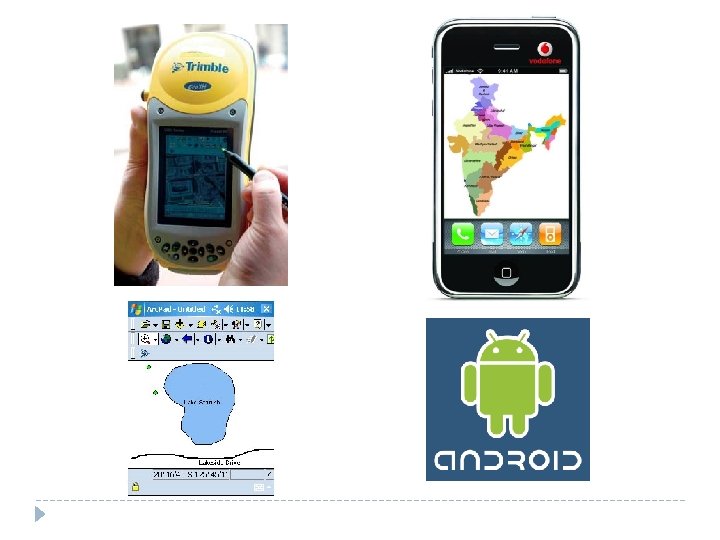
 GIS 2. 0: A Reformulation Ubiquitous communication Device convergence Widespread wired and wireless networks (voice and data) Mobile devices increasing in power and functionality Phone, camera, GPS, form-based database input, cellular, wifi Cloud computing Saa. S, Paa. S, Iaa. S Network-driven commoditization of IT

 Swift River – Crowdsource the filter
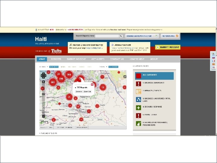
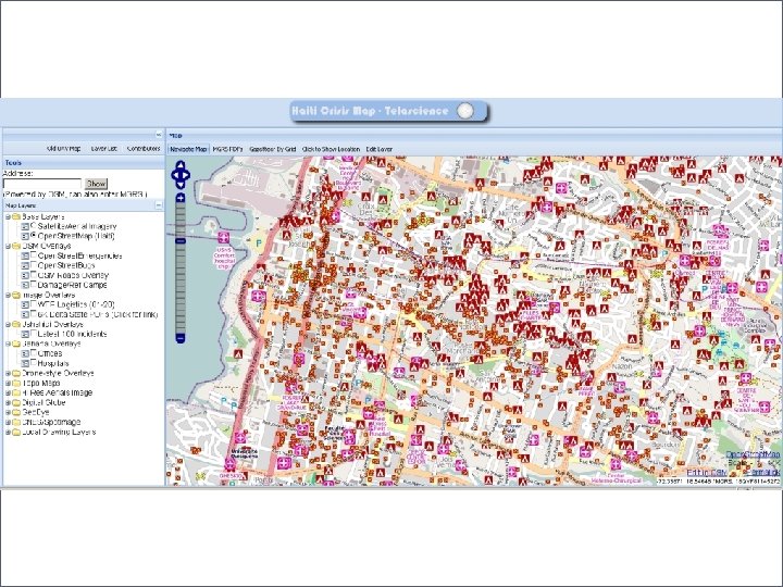
 Open Street Map – Haiti Edits Video http: //vimeo. com/9182869
 Geo. Stacks Process Driven Essentially the same process GIS + Web Publishing Neogeography Capture Produce Communicate Aggregate Consume GIS Collect Store / Retrieve Analyze Visualize Disseminate


 GIS 2. 0: Dissemination Multiple tiers of users Web mapping applications . Geo. Commons Finder!
 Geography 911 Project Goal: Design and implement a neogeography application that allows users to access, input, and modify spatially relevant data on a map of the University of Kansas Lawrence campus. Scope: . . . provides to the community the means to share geotagged content and geographic data from multiple locations in multiple formats on the internet. Content and data can be uploaded into or embedded on individual layers then be displayed on a map of the Lawrence campus. Examples of content may include photos, videos, text comments, vector-style locations (such as routes and “push-pins”), or user information
 How do people get data into the system? Data Collection On-screen") Project Architecture (Input) How do people get data into the system? Data Collection On-screen digitize, SMS, email, forms How to capture existing authoritative data? RSS, geocode Storage / Retrieval Leverage geographic nature of data requires spatial data types Post. GIS: : Arc. SDE
Project Architecture (Input) How do people get data into the system? Data Collection On-screen digitize, SMS, email, forms How to capture existing authoritative data? RSS, geocode Storage / Retrieval Leverage geographic nature of data requires spatial data types Post. GIS: : Arc. SDE
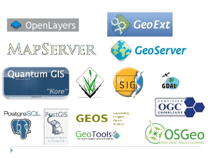
 Once data is in the system, how do people interact with") Project Architecture (Output) Once data is in the system, how do people interact with the information? Visualize Web Map Server (Geo. Server, Map. Server: : Arc. GIS Server) Map Window (Open. Layers: : ESRI Java. Script or Flex, Google) Widgets (Geo. Ext: : ESRI Java. Script (Dojo) or Flex) Styling (SLD, MAP files: : Arc. Map) (Layers, Queries, Analysis, Draw tools…) Base Layer Data (Open Street Map: : ESRI, Google, Microsoft) Storage / Retrieval SQL statements for user queries Spatial analysis functions intrinsic to spatial database
Project Architecture (Output) Once data is in the system, how do people interact with the information? Visualize Web Map Server (Geo. Server, Map. Server: : Arc. GIS Server) Map Window (Open. Layers: : ESRI Java. Script or Flex, Google) Widgets (Geo. Ext: : ESRI Java. Script (Dojo) or Flex) Styling (SLD, MAP files: : Arc. Map) (Layers, Queries, Analysis, Draw tools…) Base Layer Data (Open Street Map: : ESRI, Google, Microsoft) Storage / Retrieval SQL statements for user queries Spatial analysis functions intrinsic to spatial database
 Once data is in the system, how do people interact with") Project Architecture (Output) Once data is in the system, how do people interact with the information? Disseminate Publish data in a several different formats Web Services (OGC), KML, CSV, text…. RSS, SMS, email updates
Project Architecture (Output) Once data is in the system, how do people interact with the information? Disseminate Publish data in a several different formats Web Services (OGC), KML, CSV, text…. RSS, SMS, email updates