e3292cfcbbd5d420f401ef72aa529364.ppt
- Количество слайдов: 89
 Flood Assessment and Monitoring using RS and GIS Tamuka Magadzire USGS/FEWSNET, SADC RRSU WMO/FAO Training Workshop on GIS and Remote Sensing Applications in Agricultural Meteorology for SADC countries November 14 -18, 2005
 Outline • Introduction: understanding flood processes – Hydrological Cycle – Topography and stream networks – Surface conditions (landcover, soils, antecedence etc) • Analyzing historical and topographic flood risk • Analyzing current/unfolding flood risk – Rainfall analysis – Basin Excess Rainfall Mapping – Hydrological modeling • Flood mapping using RS • Incorporating GIS overlays
 Outline • Introduction: understanding flood processes – Hydrological Cycle – Topography and stream networks – Surface conditions (landcover, soils, antecedence etc) • Analyzing historical and topographic flood risk • Analyzing current/unfolding flood risk – Rainfall analysis – Basin Excess Rainfall Mapping – Hydrological modeling • Flood mapping using RS • Incorporating GIS overlays
 Hydrological Cycle Source: Columbia university: http: //www. ldeo. columbia. edu/~martins/climate_water/lectures/hcycle. htm
 Hydrological Cycle • The hydrological cycle is composed of a number of processes including – – – Evapotranspiration Condensation and Cloud formation Precipitation Infiltration and Percolation Runoff and stream flow Subsurface interflow • Different applications emphasize different components, based on the domain of interest
 Hydrological Cycle
 Hydrological Cycle • Flooding is as a result of complex interactions between rainfall and surface processes • Generally, the more the rainfall, the greater the likelihood of flooding • The amount of runoff generated plays a significant role in the flooding process
 Outline • Introduction: understanding flood processes – Hydrological Cycle – Topography and stream networks – Surface conditions (landcover, soils, antecedence etc) • Analyzing historical and topographic flood risk • Analyzing current/unfolding flood risk – Rainfall analysis – Basin Excess Rainfall Mapping – Hydrological modeling • Flood mapping using RS • Incorporating GIS overlays
 Topography & stream networks • Some common hydrological knowledge – Water flows downhill – Water accumulates downstream, and water falling further from river will take longer to get there – Steeper areas are less likely to be flooded than flat areas – Areas nearer the river network are more likely to be flooded – Areas downstream in flood plains are more floodprone than areas upstream nearer river source
 Topography & stream networks • In addition to this, water interactions in hydrological and flood analysis tend to be confined to river basins • GIS analysis can help us define – – the outline of the river basin the stream networks the topology of the streams and basins the topography or terrain related characteristics of a basin that have a bearing on flooding processes • A Digital Elevation Model (DEM) is required
 Topography & stream networks • A little more on DEMs – Can be defined as a digital representation of the elevation variations in the earth’s surface – Two models are common: • A raster grid • A Triangulated Irregular Network (TIN) – Many applications for hydrological analysis use raster grids – Sources of DEM include those made from: • SRTM Data • A combination of some or all of Contour, Spot height, River, Lake data *** [Recommended]
 Using Arcview’s Terrain Analysis Functions with USGS 1 km DEM Flow Direction Slope Source: USGS Flow Accumulation Subbasins Flow Length Downstream Subbasin Hill Length
 Theory behind flow analysis • Flow Direction • Flow Accumulation Source: Arc. View Help System
 Outline • Introduction: understanding flood processes – Hydrological Cycle – Topography and stream networks – Surface conditions (landcover, soils, antecedence etc) • Analyzing historical and topographic flood risk • Analyzing current/unfolding flood risk – Rainfall analysis – Basin Excess Rainfall Mapping – Hydrological modeling • Flood mapping using RS • Incorporating GIS overlays
 Surface Conditions • Surface conditions affect flooding by affecting the ratio of amount of rainfall to amount of water that infiltrates the soil • Rainfall that does not infiltrate either becomes runoff or standing/ponded water.
 Surface Conditions • Surface conditions affecting flooding include: – Soil type (water holding capacity, hydraulic conductivity) – Land cover (imperviousness) – Antecedent moisture conditions • SCS Curve Numbers are one way of quantifying the impact of rainfall on runoff
 Surface Conditions Land Cover Soil Type
 Outline • Introduction: understanding flood processes – Hydrological Cycle – Topography and stream networks – Surface conditions (landcover, soils, antecedence etc) • Analyzing historical and topographic flood risk • Analyzing current/unfolding flood risk – Rainfall analysis – Basin Excess Rainfall Mapping – Hydrological modeling • Flood mapping using RS • Incorporating GIS overlays
 Historical flood risk • An analysis of historical stream flows can help statistically determine probability of flooding at a point along the river network • This is done using a cumulative distribution analysis of stream flow, to give historical return periods for different stream flows and stage heights • This can be used to infer the severity associated with different flood return periods
 Historical flood risk – an example Return Period (years) Discharge in m 3/s Height above the Bed level (m) 2 4. 6 10 7135 8. 4 50 9194 9. 4 100 13857 11. 0 200 15847 12. 7 500 Source: ZINWA 1746 18473 12. 4
 Topographic flood risk • Areas closer to the river, and flatter areas, are more likely to be flooded by a specific rise in river level. • GIS analysis can be used to estimate the area that will be flooded by a given rise in the river level. • The main data input is a high-res DEM • The flood area for different river levels can be calculated to map the flood risk zones for different flood severities
 Topographic flood risk – an Arc. INFO application • Appropriate GIS software such as Arc. INFO can be used to calculate the topographic flood risk • Arc. INFO AML example (K. Asante): – Raise the level of the DEM along the stream network – Use the Fill Function to fill the sinks that are generated by raising the stream level. – Subtract the original DEM from the filled DEM to identify the areas affected by stream rise
 Topographic flood risk – an Arc. INFO application /* Copy the instructions below into an aml (eg makedem. aml) and run from the arc command prompt /* eg *ARC: &run makedem. aml grid setwindow indem setcell indem /* strgrid is river grid with 1's in the rivercells and 0's elsewhere fill indem # # flowdir flowacc = flowaccumulation ( flowdir ) STRGRID = con ( flowacc >= 100000, 1, 0 ) strlink = streamlink ( ( strgrid / strgrid ) , flowdir ) strline = streamline ( ( strgrid / strgrid ) , flowdir ) strgrid 1 = strgrid &do ndepth : = 1 &to 15 &by 1 newgrid%ndepth% = dem + (strgrid%ndepth%) fill newgrid%ndepth% dem%ndepth% # # flowdir%ndepth% &s ddd = %ndepth% + 1 tempgrid = dem%ndepth% - dem flowacc%ndepth% = flowaccumulation ( flowdir%ndepth% ) rivall%ndepth% = con(flowacc%ndepth% >= 100000, 1, 0) /* I am assuming a threshold here of 100, 000 cells each 30 x 30 m /* This is not automated if the main channel is the source of inundation area sgrid%ddd% = con(tempgrid > 0, (tempgrid + 1), 0) strgrid%ddd% = con((sgrid%ddd% == 0) and (rivall%ndepth% > 0) , (sgrid%ddd% + 1), sgrid%ddd%) /* This ensures that any additional cells along the critical flow path /* are included in strgrid%ddd% before the next computation of flooded area. copy kill kill &end strgrid%ddd% flood%ndepth% flowdir%ndepth% all flowacc%ndepth% all rivall%ndepth% all sgrid%ddd% all tempgrid all strgrid%ndepth% all newgrid%ndepth% all Source: Kwabena Asante, USGS
 Topographic flood risk – an Arc. INFO application &do ndepth : = 1 &to 15 &by 1 newgrid%ndepth% = dem + (strgrid%ndepth%) fill newgrid%ndepth% dem%ndepth% # # flowdir%ndepth% &s ddd = %ndepth% + 1 tempgrid = dem%ndepth% - dem flowacc%ndepth% = flowaccumulation ( flowdir%ndepth% ) rivall%ndepth% = con(flowacc%ndepth% >= 100000, 1, 0) sgrid%ddd% = con(tempgrid > 0, (tempgrid + 1), 0) strgrid%ddd% = con((sgrid%ddd% == 0) and (rivall%ndepth% > 0) , (sgrid%ddd% + 1), sgrid%ddd%) /* This ensures that any additional cells along the critical flow path /* are included in strgrid%ddd% before the next computation of flooded area. copy kill kill &end strgrid%ddd% flood%ndepth% flowdir%ndepth% all flowacc%ndepth% all rivall%ndepth% all sgrid%ddd% all tempgrid all strgrid%ndepth% all newgrid%ndepth% all Source: Kwabena Asante, USGS
 Topographic flood risk – some results • Such an analysis was done for Chokwe district to determine which settlements would be affected by different river rises. • Similar analysis was done using SRTM DEM for Beitbridge
 Example 1 CHOKWE
 Topographic flood risk – some results Determinação de Área Inundada Usando DEM e Alturas Previstas Source: USGS & ARA-Sul, Mozambique
 MAPA DE INUNDAÇÃO DO DISTRITO DE CHÒKWÉ, E 35 Alt. 4 -6 m Cidade: Macarretan e Aldeias: Conhane e Mapapa
 MAPA DE INUNDAÇÃO DO DSTRITO DE CHOKWE, E 35 Alt 6 -8 m Cidade: Macarretane Aldeias: Muzumuia, Muianga, Conhane, Mapapa, Chiaquelane, Marranbandjane, Chiguidela, Malhazene, Chalucuane, Zuza e Chiduchine
 MAPA DE INUNDAÇÃO DO DISTRITO DE CHÒKWÉ Altura: 8 -10 m Cidades: Macarretane, Chòkwè e Lionde Aldeias: Muzumuia, Massavasse, Nwachicoloane, Changulene, Muianga, Conhane, Mapapa, Chiaquelane, Marrambandjane , Chiguidela, Malhazene, Chalucuane, Zuza e Chiduachine
 Example 2 BEITBRIDGE
 SRTM DEM
 Potential flood areas: 1 m Source: SADC RRSU
 Potential flood areas: 10 m Notice the “line” down the centre of the flood map. Answer later Source: SADC RRSU
 Potential flood areas: 15 m Source: SADC RRSU
 DEM Errors “DEM Errors” shown in brown. These are the areas that are filled during the Fill operation Reason for lines in flood areas analysis Source: SADC RRSU
 Combining Statistical and Topographic Flood Risk The Beitbridge Study
 Flood Risk
 Flood Risk
 Flood Risk
 Flood Risk
 Outline • Introduction: understanding flood processes – Hydrological Cycle – Topography and stream networks – Surface conditions (landcover, soils, antecedence etc) • Analyzing historical and topographic flood risk • Analyzing current/unfolding flood risk – Rainfall analysis – Basin Excess Rainfall Mapping – Hydrological modeling • Flood mapping using RS • Incorporating GIS overlays
 Rainfall Analysis • When there is lots and lots of rain, result is often (not always) flooding. • So a first step in analyzing unfolding flood risk is simple rainfall analysis • A subjective analysis that benefits greatly from an enhanced knowledge of the area under analysis, of the recent rainfall history, as of the events upstream • Daily rainfall observations over the last few days, and QPF are useful for heavy storms, while dekadal (10 -day) sums are useful for persistent weather • Encourage use of improved rainfall grids incorporating rain-gauge and satellite data
 Rainfall Analysis • Every day, NOAA CPC produces Rainfall Estimates for the FEWSNET activity. • These RFE, as well as QPF are put on the USGS FEWSNET website as graphics: – http: //earlywarning. usgs. gov/adds • The actual data can also be downloaded: – http: //edcwww. cr. usgs. gov/pub/edcuser/fewsips/africa/
 Rainfall Analysis
 Rainfall Analysis of potential flood situation March 2001
 Rainfall Analysis – an example • There was much flooding in 2001, which was analyzed, tracked and reported on in the Regional Flood Watch • The following analysis shows how rainfall estimates, rainfall proxies, and rainfall forecasts were used to track the flood likelihood
 Cold Cloud Duration Daily Rainfall Estimates Quantitative Precipitation Forecasts
 Rainfall Analysis of potential flood situation March 2003
 Rainfall Analysis – an example • Example of rainfall analysis that was done to support the Regional Flood Watch in anticipation of Cyclone Japhet in March 2003. • The following example illustrates the use of rainfall estimates and the incorporation of antecedent moisture conditions in the analysis
 Rainfall Analysis – an example • Rainfall associated with Cyclone Japhet
 Rainfall Analysis – an example • Antecedent moisture conditions have an influence on flooding
 Outline • Introduction: understanding flood processes – Hydrological Cycle – Topography and stream networks – Surface conditions (landcover, soils, antecedence etc) • Analyzing historical and topographic flood risk • Analyzing current/unfolding flood risk – Rainfall analysis – Basin Excess Rainfall Mapping – Hydrological modeling • Flood mapping using RS • Incorporating GIS overlays
 Basin Excess Rainfall Maps • One large advantage of rainfall analysis is its simplicity • Rainfall analysis has it’s limitations – very subjective, and does not consider basin characteristics or climatology of basin • Rainfall that falls within a basin [is converted to runoff, and] accumulates within a basin, affecting flooding downstream within the basin • Analysis of basin-specific rainfall is therefore useful for flood analysis
 Basin Excess Rainfall Maps • Basin Excess Rainfall Maps (BERMs) are one solution. USGS produces and updates BERMs operationally (http: //earlywarning. usgs. gov/adds) • BERMs are maps which highlight: – basins experiencing above-average rainfall in the previous ten-day period – river reaches with potentially higher-than-average stream flow • BERM products reveal basins and streams experiencing sustained heavy regional rains with increased likelihood of flooding at locations within the basin
 Basin Excess Rainfall Maps • For basin analysis, process is as follows: – Sum RFE over each basin for: • 3 day period • Dekad • Cumulatively for the season – Divide the basin sums by the corresponding long-term average – Assign excess rainfall scores to basins and rivers – Make maps of basins with color codes indicating the excess rainfall score for each basin. This is the BERM
 Basin Excess Rainfall Maps Source: USGS/FEWSNET
 Basin Excess Rainfall Maps • Two types of maps are produced: – The basin (or catchment) map highlights subbasins locally (i. e. rain falling in sub-basin only) receiving above-average precipitation by color coding the relevant polygons. – The stream map highlights reaches of river [regionally] receiving above-average amounts of precipitation from all areas upstream of them • Thus, a subbasin may not be highlighted if only light rain is occurring locally, while the stream passing through may be highlighted, due to heavy rains in upstream catchments
 Basin Excess Rainfall Maps Source: USGS/FEWSNET
 Outline • Introduction: understanding flood processes – Hydrological Cycle – Topography and stream networks – Surface conditions (landcover, soils, antecedence etc) • Analyzing historical and topographic flood risk • Analyzing current/unfolding flood risk – Rainfall analysis – Basin Excess Rainfall Mapping – Hydrological modeling • Flood mapping using RS • Incorporating GIS overlays
 Hydrological Modelling • Advantages of BERMs is that – they are simple to produce and do not require much extra information or calculation – They account for basin, and upstream rainfall • Disadvantage is that – they do not account for basin characteristics such as soil type, landcover, and antecedent moisture conditions – they do not explicitly account for transport time of water from upstream basins • Full-fledged hydrological modelling should take all these factors into account
 Hydrological Modelling • The USGS has developed a geo-spatial Stream Flow Model that uses daily evapotranspiration and precipitation data to predict stream flow, and consequently, flood risk
 FEWS Flood Risk Monitoring System Flow Diagram Data RFE Preprocessing Stream Flow Model Output / Decision Support System MAP QPF PET Water Balance MAE Basin Linkage Soil LU/LC Lumped Routing Parameters Soil Parameters Dist. Routing Flood Inundation Mapping DEM Source: USGS Updating Landsat 7 SPOT
 Water Balance Conceptual Model
 Runoff Response Function Flow time from cell to s outlet Aggregate flow times for each day
 Flood Routing Network Sub-basin 1 Sub-basin 2 + Main channel + Sub-basin 3 Sub-basin 4 Main channel + Outlet
 Arc. View Interface
 Stream Flow Model Some Derived Model Inputs
 Flow direction Flow Accumulation Flow Length HYDRO 1 K DEM Derivatives Terrain slope Hill Length Sub-basin Linkage
 USGS Global Land Cover Characteristics
 FAO Digital Soil Map of the World
 Soil Depth Soil WHC Hydraulic Conductivity Soil and Land Cover Data SCS Curve No. Texture Maximum Impervious
 Outline • Introduction: understanding flood processes – Hydrological Cycle – Topography and stream networks – Surface conditions (landcover, soils, antecedence etc) • Analyzing historical and topographic flood risk • Analyzing current/unfolding flood risk – Rainfall analysis – Basin Excess Rainfall Mapping – Hydrological modeling • Flood mapping using RS • Incorporating GIS overlays
 Flood Mapping Using RS • Satellites are often used for flood mapping • Optical and radar sensors have varied advantages and disadvantages • Optical – Many optical sensors available at varying spatial resolution, providing high temporal resolution to monitor flood evolution – Are affected by cloud cover • Radar – Are not affected by cloud cover – Difficult to get, often expensive, and need to be ordered in advance
 Flood Mapping Using RS • Freely available data can be downloaded from internet, e. g. MODIS • Disadvantage: internet speeds in much of Africa are often prohibitive for downloading these large datasets. • Disadvantage 2 is that some of the images are not available in near-real time and so are not useful for flood monitoring • One alternative is to download smaller, pre-processed graphics from the internet, and these can be georeferenced for further analysis • Data can also be purchased, or requested from appropriate partners, or through Disaster Management EO Charter
 Flood Mapping Using RS • Processing of optical data to produce flood map: – Water generally has the lowest reflectance in many of the ranges of the optical spectrum – This property can be used to identify water using a simple classification procedure – Disadvantage: water is easily confused with shade (e. g. cloud shadow), so classification cannot be completely automated
 Flood mapping using Remote Sensing Some Examples
 Example 1 • ERS SAR image • Tropical Storm Russ • China, 1994 Source: DFO: www. dartmouth. edu/~floods
 Example 2 Source: DFO: www. dartmouth. edu/~floods
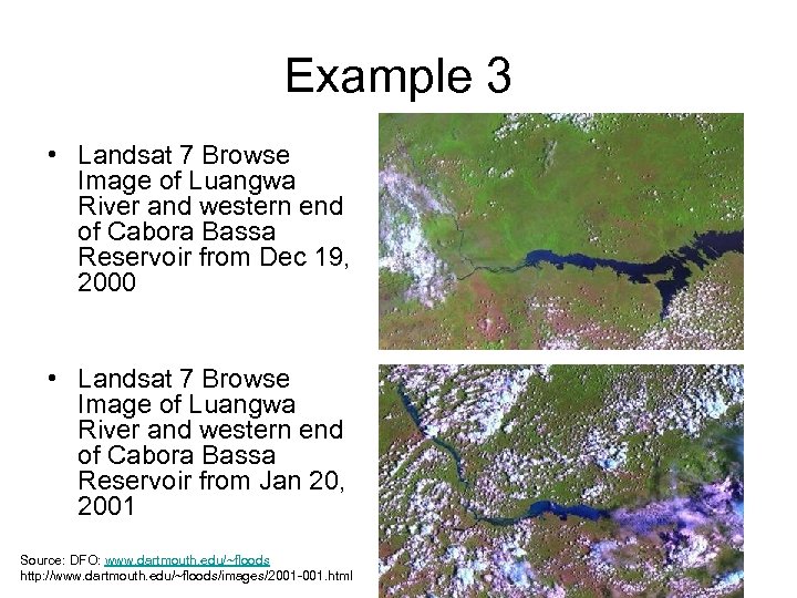 Example 3 • Landsat 7 Browse Image of Luangwa River and western end of Cabora Bassa Reservoir from Dec 19, 2000 • Landsat 7 Browse Image of Luangwa River and western end of Cabora Bassa Reservoir from Jan 20, 2001 Source: DFO: www. dartmouth. edu/~floods http: //www. dartmouth. edu/~floods/images/2001 -001. html
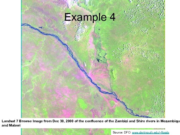 Example 4 Landsat 7 Browse Image from Dec 30, 2000 of the confluence of the Zambizi and Shire rivers in Mozambique and Malawi Source: DFO: www. dartmouth. edu/~floods
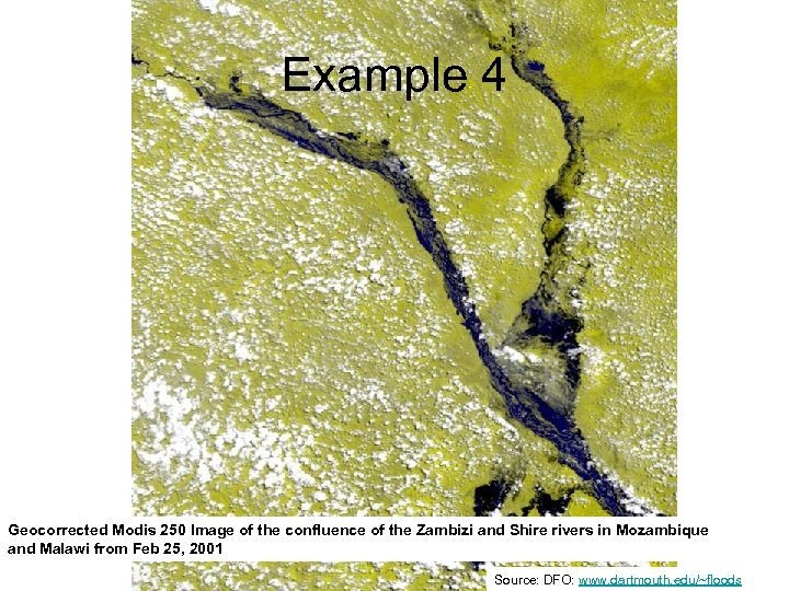 Example 4 Geocorrected Modis 250 Image of the confluence of the Zambizi and Shire rivers in Mozambique and Malawi from Feb 25, 2001 Source: DFO: www. dartmouth. edu/~floods
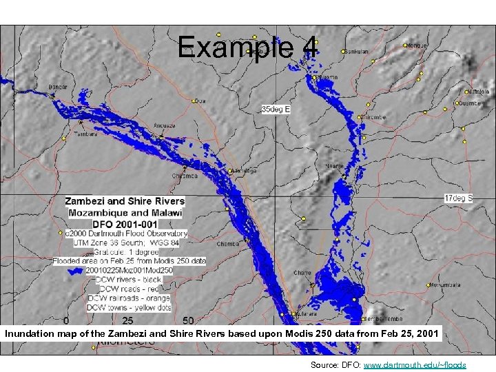 Example 4 Inundation map of the Zambezi and Shire Rivers based upon Modis 250 data from Feb 25, 2001 Source: DFO: www. dartmouth. edu/~floods
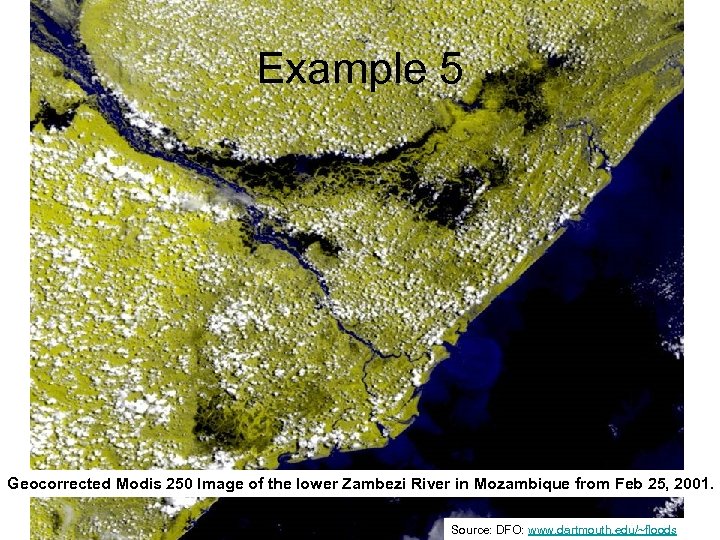 Example 5 Geocorrected Modis 250 Image of the lower Zambezi River in Mozambique from Feb 25, 2001. Source: DFO: www. dartmouth. edu/~floods
 Flood Mapping Using RS • So why Do-It-Yourself when you can get all these good maps on the web? • Some good reasons include: – Timeliness – Incorporation of locally available relevant datasets (cities, population, infrastructure etc)
 Outline • Introduction: understanding flood processes – Hydrological Cycle – Topography and stream networks – Surface conditions (landcover, soils, antecedence etc) • Analyzing historical and topographic flood risk • Analyzing current/unfolding flood risk – Rainfall analysis – Basin Excess Rainfall Mapping – Hydrological modeling • Flood mapping using RS • Incorporating GIS overlays
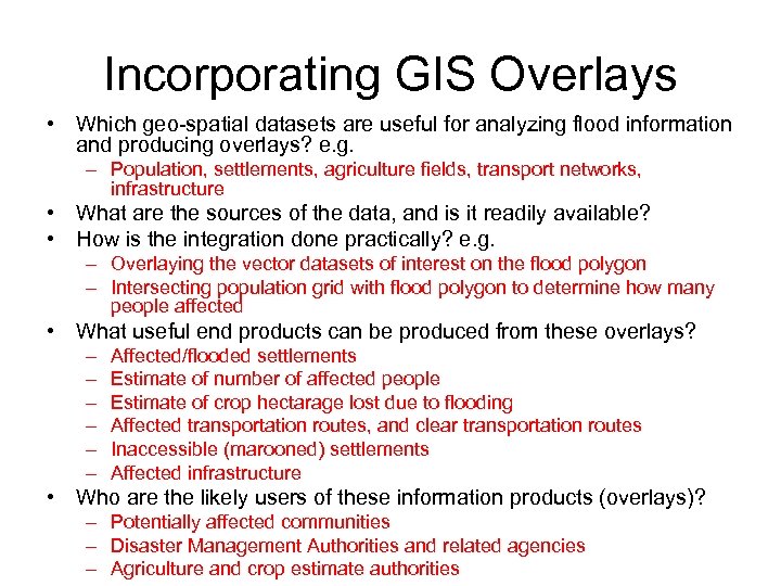
 Incorporating GIS Overlays • Which geo-spatial datasets are useful for analyzing flood information and producing overlays? • What are the sources of the data, and is it readily available? • How is the integration done practically? • What useful end products can be produced from these overlays? • Who are the likely users of these information products (overlays)?
 Incorporating GIS Overlays • Which geo-spatial datasets are useful for analyzing flood information and producing overlays? e. g. – Population, settlements, agriculture fields, transport networks, infrastructure • What are the sources of the data, and is it readily available? • How is the integration done practically? e. g. – Overlaying the vector datasets of interest on the flood polygon – Intersecting population grid with flood polygon to determine how many people affected • What useful end products can be produced from these overlays? – – – Affected/flooded settlements Estimate of number of affected people Estimate of crop hectarage lost due to flooding Affected transportation routes, and clear transportation routes Inaccessible (marooned) settlements Affected infrastructure • Who are the likely users of these information products (overlays)? – Potentially affected communities – Disaster Management Authorities and related agencies – Agriculture and crop estimate authorities
 End-of-File • Thank You


