e26abc288f52586b1b01c9ab67461048.ppt
- Количество слайдов: 16
 FAA Tactical Weather Forecasting In The United States National Airspace Bill Dupree Marilyn Wolfson Rick Johnson, Jr. Bob Boldi Evelyn Mann Kim Theriault Calden Carol Wilson Paul Bieringer Brian Martin Haig Iskenderian WSN 05 Toulouse 1 WJD 3/18/2018 MIT Lincoln Laboratory
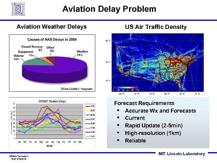 Aviation Delay Problem Aviation Weather Delays US Air Traffic Density Forecast Requirements • Accurate Wx and Forecasts • Current • Rapid Update (2 -5 min) • High-resolution (1 km) • Reliable WSN 05 Toulouse 2 WJD 3/18/2018 MIT Lincoln Laboratory
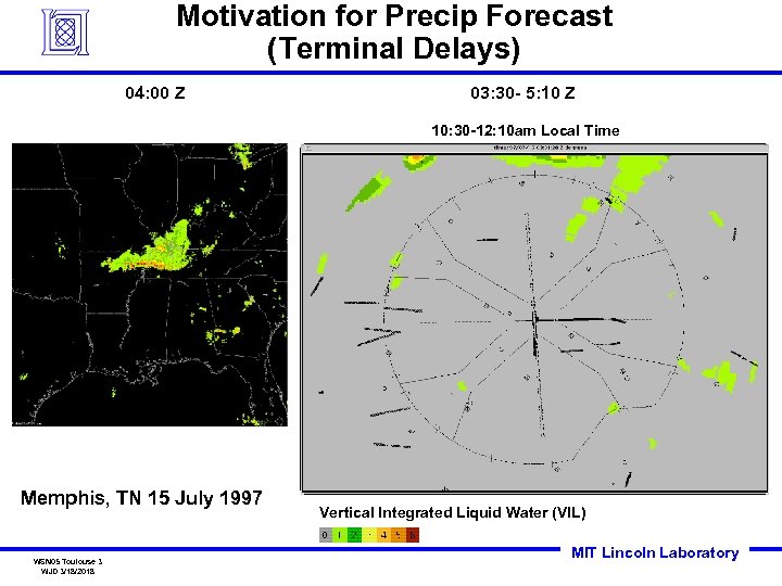 Motivation for Precip Forecast (Terminal Delays) 04: 00 Z 03: 30 - 5: 10 Z 10: 30 -12: 10 am Local Time Memphis, TN 15 July 1997 WSN 05 Toulouse 3 WJD 3/18/2018 Vertical Integrated Liquid Water (VIL) MIT Lincoln Laboratory
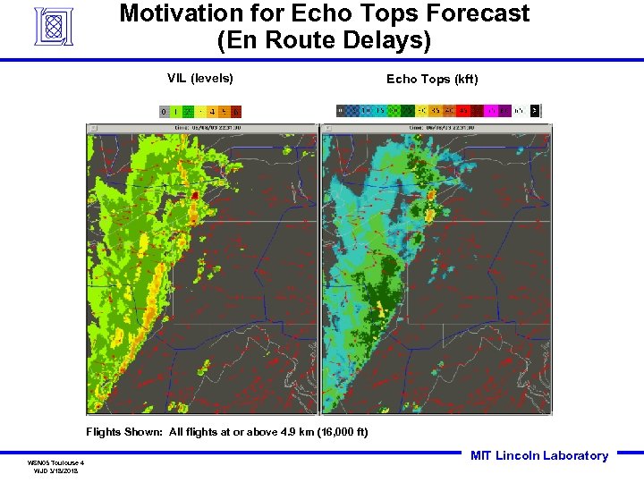 Motivation for Echo Tops Forecast (En Route Delays) VIL (levels) Echo Tops (kft) Flights Shown: All flights at or above 4. 9 km (16, 000 ft) WSN 05 Toulouse 4 WJD 3/18/2018 MIT Lincoln Laboratory
 Overview • Problem • 0 -2 Hour Weather Forecast System – – • WSN 05 Toulouse 5 WJD 3/18/2018 Evolution of Forecast System Forecast Components Forecast Products Performance Research Efforts MIT Lincoln Laboratory
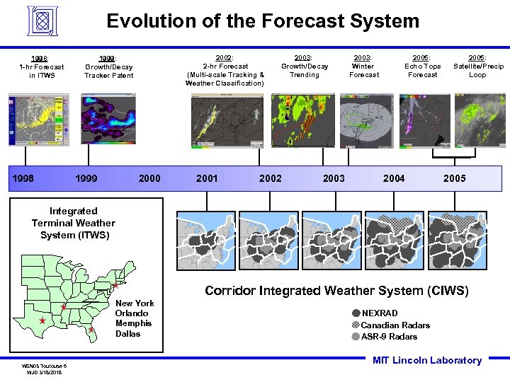 Evolution of the Forecast System 1998: 1 -hr Forecast in ITWS 1998 2002: 2 -hr Forecast (Multi-scale Tracking & Weather Classification) 1999: Growth/Decay Tracker Patent 1999 2000 2001 2003: Growth/Decay Trending 2002 2003: Winter Forecast 2005: Echo Tops Forecast 2004 2005: Satellite/Precip Loop 2005 Integrated Terminal Weather System (ITWS) Corridor Integrated Weather System (CIWS) New York Orlando Memphis Dallas WSN 05 Toulouse 6 WJD 3/18/2018 NEXRAD Canadian Radars ASR-9 Radars MIT Lincoln Laboratory
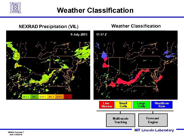 Weather Classification NEXRAD Precipitation (VIL) 9 July 2003 17: 17 Z Line Storms Small Cells Multi-scale Tracking WSN 05 Toulouse 7 WJD 3/18/2018 Large Cells Stratiform Rain Forecast Engine MIT Lincoln Laboratory
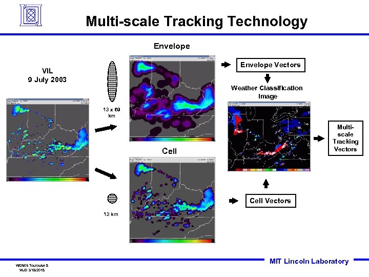 Multi-scale Tracking Technology Envelope Vectors VIL 9 July 2003 Weather Classification Image 13 x 69 km Multiscale Tracking Vectors Cell Vectors 13 km WSN 05 Toulouse 8 WJD 3/18/2018 MIT Lincoln Laboratory
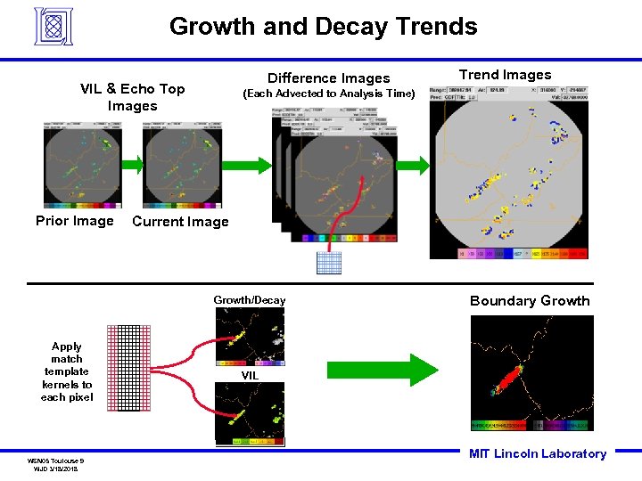 Growth and Decay Trends Difference Images VIL & Echo Top Images Prior Image (Each Advected to Analysis Time) Current Image Growth/Decay Apply match template kernels to each pixel WSN 05 Toulouse 9 WJD 3/18/2018 Trend Images Boundary Growth VIL MIT Lincoln Laboratory
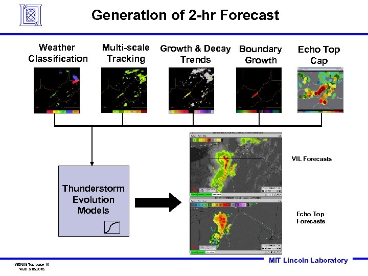 Generation of 2 -hr Forecast Weather Classification Multi-scale Tracking Growth & Decay Boundary Trends Growth Echo Top Cap VIL Forecasts Thunderstorm Evolution Models WSN 05 Toulouse 10 WJD 3/18/2018 Echo Top Forecasts MIT Lincoln Laboratory
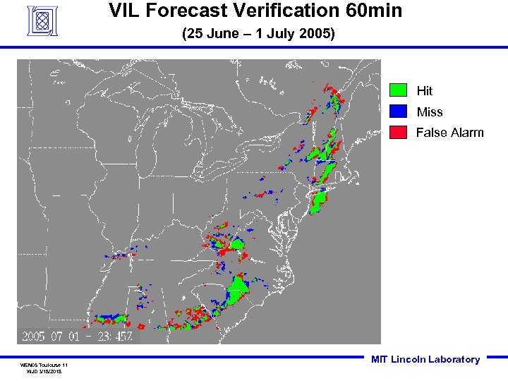 VIL Forecast Verification 60 min (25 June – 1 July 2005) Hit Miss False Alarm WSN 05 Toulouse 11 WJD 3/18/2018 MIT Lincoln Laboratory
 Overview • • 0 -2 Hour Weather Forecast System • WSN 05 Toulouse 12 WJD 3/18/2018 Problem Research Efforts MIT Lincoln Laboratory
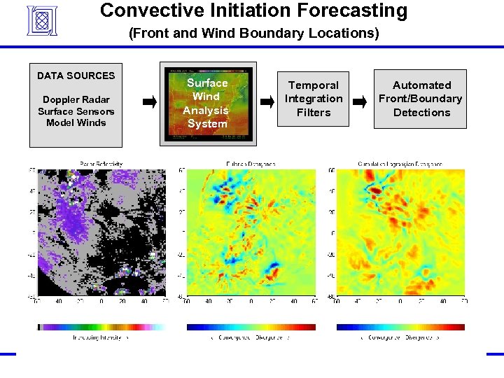 Convective Initiation Forecasting (Front and Wind Boundary Locations) DATA SOURCES Doppler Radar Surface Sensors Model Winds WSN 05 Toulouse 13 WJD 3/18/2018 Surface Wind Analysis System Temporal Integration Filters Automated Front/Boundary Detections MIT Lincoln Laboratory
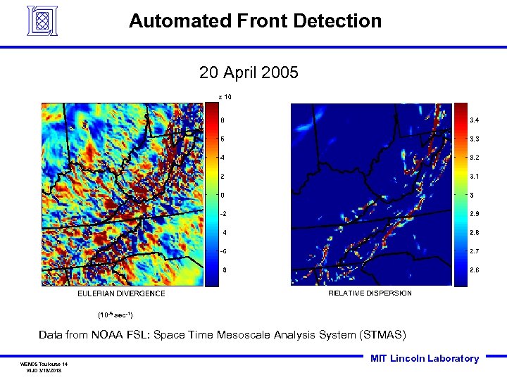 Automated Front Detection 20 April 2005 (10 -5 sec-1) Data from NOAA FSL: Space Time Mesoscale Analysis System (STMAS) WSN 05 Toulouse 14 WJD 3/18/2018 MIT Lincoln Laboratory
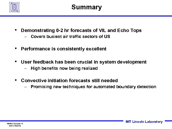 Summary • Demonstrating 0 -2 hr forecasts of VIL and Echo Tops – Covers busiest air traffic sectors of US • Performance is consistently excellent • User feedback has been crucial in system development – High benefits now being realized • Convective initiation forecasts still needed – Promising new techniques for automated boundary detection WSN 05 Toulouse 15 WJD 3/18/2018 MIT Lincoln Laboratory
 End of presentation WSN 05 Toulouse 16 WJD 3/18/2018 MIT Lincoln Laboratory


