

728540bd4b5e9b05db0c2c479ee42fb4.ppt
- Количество слайдов: 16
 EDCSS Support to JLVC Steve Lowe, John Holdzkom Modeling & Simulation Division Atmospheric & Environmental Research, Inc. 1
 EDCSS Support to JNTC ll die n Au ng ini Awareness Ce EDCSS Event Support ite Tra Situational Wh (C 4 ISR) ce Simulated Operational Products Google. Earth Simulation Domain NWARS-ng • Targeting • Mobility • CBRNE • Acoustic Detection • IR Targeting • MISREP Reports • Base Weather • ISR Collections
 EDCSS Process for Training Event Support EDCSS Production Site Consistent, Multi-Domain Environmental Scenario Data Effects Imagery Messages Project Conditions, Place/Time, Components DMZ Event Planners DMZ EDCSS Distributor HTTP Simulation Network C 4 I Domain RIM AWSIM RIM JCATS NWARS RIM JSAF HLA Simulation Network JBUS Simulation Control White Cell Trainees HLA–to-C 4 I Bridge RIM = Runtime Integration Module HLA = High-Level Architecture 3
 EDC Distributor Client and Runtime API EDC Distributor Product-Based Web Services SOAP / XML ZIP Files EDC Runtime Integration Module Java App EDC Dist. Client Product Cache Load product files (in requested format) Java App EDC Runtime EDC RIM API Data Cache get. Data(Parm, Level, Time, Lat, Lon) Simulation Application 4
 Advantages of RIM usage n Automation of product download from Distributor Ø Downloads by component (e. g. JCATS, AWSIM, etc. ) Ø Right products at the right time Ø Future … • n The Distributor will have “scenario control” features added that will allow centralized management of game-time changes to the weather scenario in play. These changes will be very difficult to respond to with the current manual process. Optional Programming Interface to Data/Effects Ø Applications can code to RIM API for efficient access to data (or pre-computed effects) by Time, Lat, and Lon. Ø JSAF JBUS capability already built to utilize RIM Data API Ø AWSIM Hypercube Read-API is prototype for RIM Effects API 5
 EDCSS Version 1. 3 n EDC Production Web Site All current JLVC products fully automated Ø Automatic Date Rolling (historical to scenario) Ø System Impacts Service / Rules Management Ø User Roles Ø n EDC Distributor Ø Locally managed Exercise Support Site • Site improvements (classification banner, tab layout) User Security Ø Product download via web service by hour (V 1. 2 supports date only) Ø n EDC Runtime Integration Module Improved polling logic in Distributor Client (still a pull, no push) Ø Automated population of RIM Data Cache Ø API implementation improvements driven by JSAF / JBUS integration Ø 6
 BACKUP SLIDES 7
 EDCSS Supported Events n TF-09 Support Ø Ø Ø n Produced full suite of EDCSS products to support PACOM defined scenario • Daily weather briefing to training audience by PACOM Senior METOC Officer Exercise Support Site available in TB 30 (JTEN) “Manual Adjudication” in JLVC simulation NWDC JSAF played correlated ocean representation EDCSS products made available on Navy Oceanography Portal AC-09 Support Ø Produced full suite of EDCSS products to support EUCOM defined scenario Ø Ops Weather Squadron ingested EDCSS products • • Ø Over 10, 000 weather products used to support exercise 290, 000 synthetic observations “consensus from all levels that products were realistic, consistent, and relevant to the warfighter” (USEUCOM Senior METOC Officer) 8
 AF Atmos Navy Ocean JMB Data Standards EDCSS Production Site Ad- Hoc Sources EDCSS Production Site COSINE Mineable Databases Data Effects Imagery Messages Satellite Imagery Hypercube Product Generatio n Graphics (KML) METAR/TAF System Impacts • SEIS • Terrain Data • WRF Output 9
 EDCSS Requirements Data Model Project JCATS AWSIM White Cell JET * Components When Where Who AWSIM * Products Data Generation Service IR Hypercube JLVC CSV Spatial Resolution/Projection Available Increments Effects JSAF GRIB Text Image METAR TAF Weather Graphics Synthetic Satellite 10
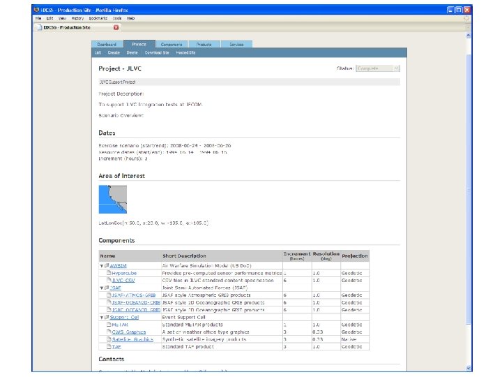
 EDCSS Product Samples EDCSS Exercise Support Site 12/12
 Probability of Detection Satellite Radar") EDCSS Product Portfolio Satellite/Radar (Google Earth) Probability of Detection Satellite Radar
EDCSS Product Portfolio Satellite/Radar (Google Earth) Probability of Detection Satellite Radar
 Soil moisture content Systems impact (stop light chart) Ocean wave") EDCSS Product Portfolio (Cont) Soil moisture content Systems impact (stop light chart) Ocean wave dir/height Weather synopsis
EDCSS Product Portfolio (Cont) Soil moisture content Systems impact (stop light chart) Ocean wave dir/height Weather synopsis
 Sensor Properties") Hypercube Concept Example: IR Sensor modeling using Target Acquisition Weapons Software (TAWS) Sensor Properties 4 Target Types 4 Sensors 4 Target Orientations 8 Sensor-Target Azimuths 5 Sensor-Target Ranges 3 Sensor Altitudes 3 Background Types 24 Times per day 400 Lat/Lon locations => 220 million TAWS computations Atmospheric Transmission Target Thermal Properties Background Thermal Properties The Payoff – Runtime Access in Milliseconds !! 15
Hypercube Concept Example: IR Sensor modeling using Target Acquisition Weapons Software (TAWS) Sensor Properties 4 Target Types 4 Sensors 4 Target Orientations 8 Sensor-Target Azimuths 5 Sensor-Target Ranges 3 Sensor Altitudes 3 Background Types 24 Times per day 400 Lat/Lon locations => 220 million TAWS computations Atmospheric Transmission Target Thermal Properties Background Thermal Properties The Payoff – Runtime Access in Milliseconds !! 15
 Hypercube Concept n Provide pre-computed performance data for simulations that can’t afford the computational burden at run-time Ø n Compute a desired metric for an n-dimensional parameterized space Ø n Use a physics solution to a slightly different problem Pd = f (Sensor, Target, Background, Weather, Tactics) Provide a simple API to allow applications to rapidly sample that space for the closest match to the run-time situation Ø Provides for multi-dimensional interpolation, as appropriate 16