

9c931b826b1acd3af34a589d05cc4bec.ppt
- Количество слайдов: 37
 DEPARTMENT OF PRIMARY INDUSTRIES Demonstrating delivery of Geological Data using Web Feature and Web Mapping Services based on international standards Bruce Simons & Alistair Ritchie Geo. Science Victoria, Minerals & Petroleum
 IUGS Commission for the Management and Application") Geo. Science Markup Language (Geo. Sci. ML) IUGS Commission for the Management and Application of Geoscience Information (CGI) § Design Task Group: § Geo. Sci. ML is a Geography Markup Language (GML) schema for sharing geological information § Testbed Task Group: § Demonstrate Geo. Sci. ML using Web Feature and Web Mapping Services § Also Service Architecture, Use-cases & Requirements, Technical Assistance, and Content Task Groups
Geo. Science Markup Language (Geo. Sci. ML) IUGS Commission for the Management and Application of Geoscience Information (CGI) § Design Task Group: § Geo. Sci. ML is a Geography Markup Language (GML) schema for sharing geological information § Testbed Task Group: § Demonstrate Geo. Sci. ML using Web Feature and Web Mapping Services § Also Service Architecture, Use-cases & Requirements, Technical Assistance, and Content Task Groups
 Testbed 2 Data Sources Canada USA France GSC schema USGS schema BRGM schema BGS UK Sweden Australia schema SGU schema GA schema WMS WFS WMS WFS Geo Sci. M L Geo. Sci. ML GML L Geo. Sci. M Client ci. ML L ci. M o. S S Geo Ge
") Remember: § Service not designed to work with any specific software package (eg ESRI) § Uses open community defined standards (ISO, Open. GIS) § Uses a rich scientific data model (eg Geo. DATA. Vic) § Complex Feature GML 3. 1 § Not “traditional” flat GIS data structures § About exchange of data (not use of data)
Remember: § Service not designed to work with any specific software package (eg ESRI) § Uses open community defined standards (ISO, Open. GIS) § Uses a rich scientific data model (eg Geo. DATA. Vic) § Complex Feature GML 3. 1 § Not “traditional” flat GIS data structures § About exchange of data (not use of data)
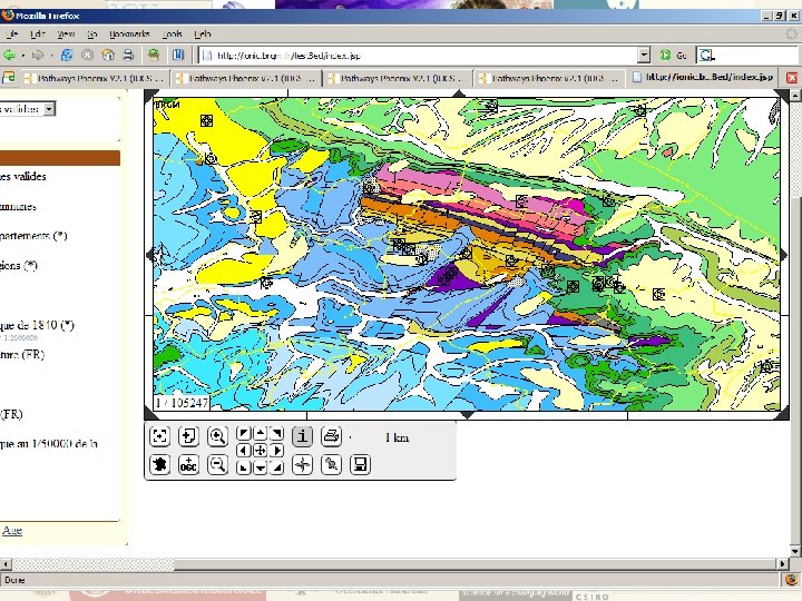
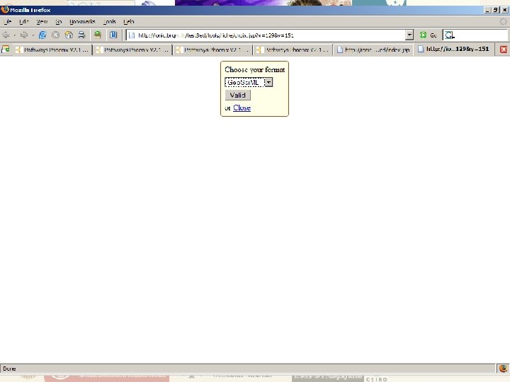
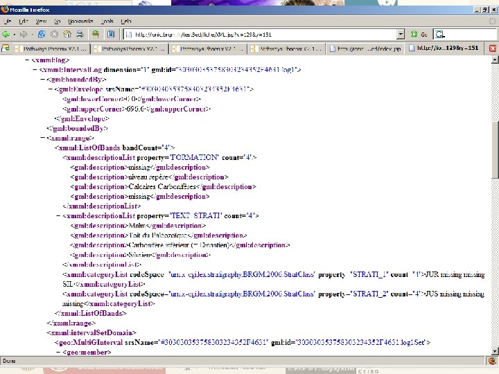
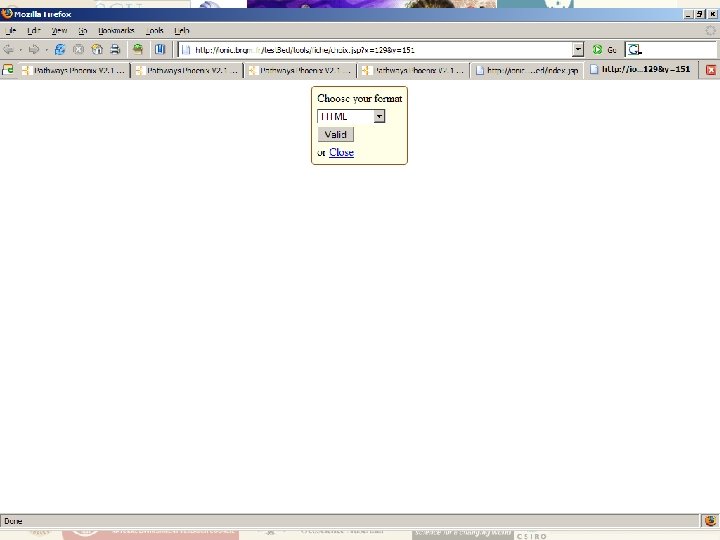
 USE CASE ONE Get Feature Information § § Display map Query one feature (a geometry) Return attributes in Geo. Sci. ML format Bonus - Return attributes as “pretty” HTML formatted Geo. Sci. ML
 DEPARTMENT OF PRIMARY INDUSTRIES
 DEPARTMENT OF PRIMARY INDUSTRIES
 DEPARTMENT OF PRIMARY INDUSTRIES
 DEPARTMENT OF PRIMARY INDUSTRIES
 DEPARTMENT OF PRIMARY INDUSTRIES
 DEPARTMENT OF PRIMARY INDUSTRIES
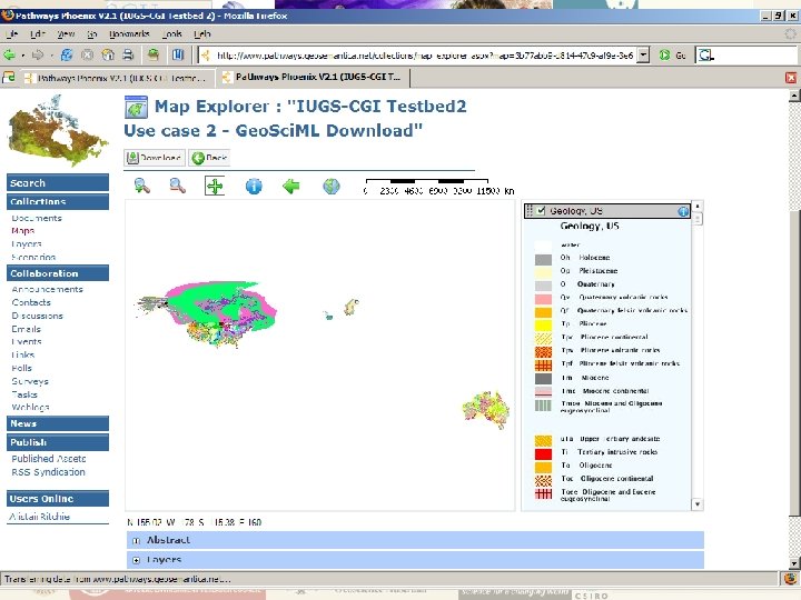
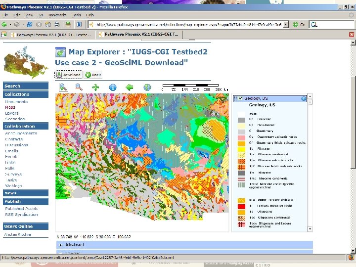
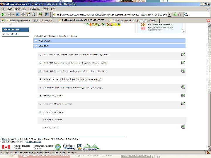
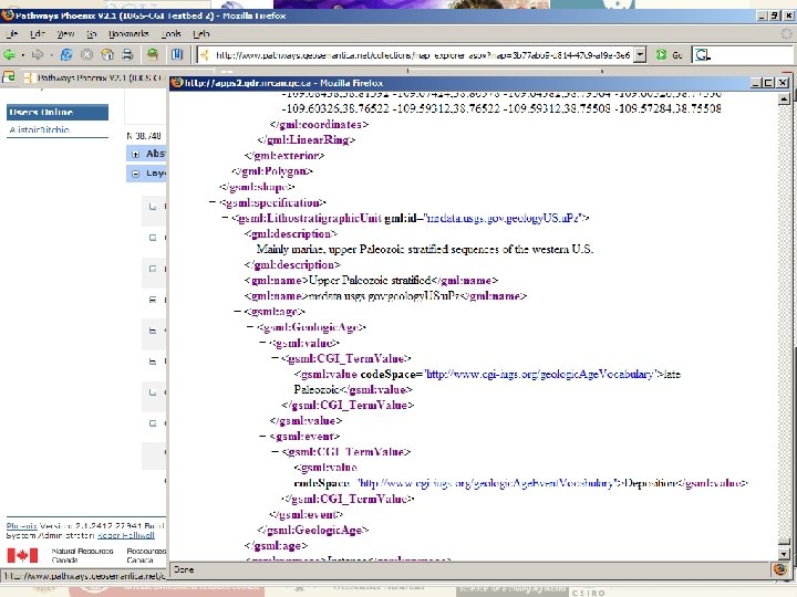
 USE CASE TWO Geo. Sci. ML Data Download § Display map § Select several features § Return attributes of the selected features as Geo. Sci. ML file for download

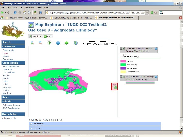
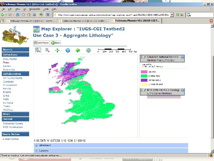
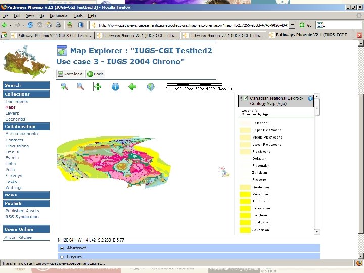
 USE CASE THREE Thematic Mapping § Reclassify map features based on § Lithology § Geological Age § Essentially produce two thematic maps

 § Developed by UK (BGS) and France (BRGM)") OTHER WORK Boreholes (from Testbed 1) § Developed by UK (BGS) and France (BRGM) § Delivery of Boreholes data
OTHER WORK Boreholes (from Testbed 1) § Developed by UK (BGS) and France (BRGM) § Delivery of Boreholes data
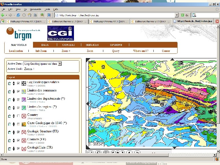
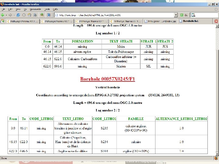
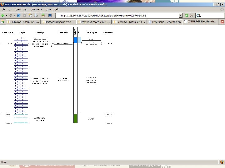
 OTHER WORK Boreholes – BRGM Client § Display Boreholes points from WFS § Select Borehole § Display borehole attributes as: § Geo. Sci. ML/XMML § “Pretty” HTML based on Geo. Sci. ML § Graphic Log based on Geo. Sci. ML

 One service – many uses GML-based data can be …. Rendered into a queryable map … … formatted into a report or …. Condition: community-standard data model/encoding … read and used by any WFS/GML enabled application
") DPI Involvement § Geo. Sci. ML Task Groups: § Design (Bruce Simons – Chair) § Testing (Alistair Ritchie) § Content (Linda Bibby) § Geo. DATA. Vic: § Developing a rich geological information system § Gold Undercover Initiative § Infrastructure § Web Service tools
DPI Involvement § Geo. Sci. ML Task Groups: § Design (Bruce Simons – Chair) § Testing (Alistair Ritchie) § Content (Linda Bibby) § Geo. DATA. Vic: § Developing a rich geological information system § Gold Undercover Initiative § Infrastructure § Web Service tools
 Why? Minerals Exploration Action Agenda Pre-competitive Geoscience Strategy “Governments in consultation with industry, to develop and implement nation-wide protocols, standards and systems that provide internet-based access to, and effective storage and archiving of geoscience datasets and industrygenerated exploration data”
 Geo. Sci. ML") What? Interoperability semantic schematic syntax systems Responsible Community Ontology (data content) Geo. Sci. ML (data structure) Geography Markup (data language) Language Web Feature Services, Web Mapping Services (data systems) Geoscience Community Open. GIS Community
What? Interoperability semantic schematic syntax systems Responsible Community Ontology (data content) Geo. Sci. ML (data structure) Geography Markup (data language) Language Web Feature Services, Web Mapping Services (data systems) Geoscience Community Open. GIS Community
 Next § Geo. Sci. ML 2 Design Task Group: • March 2007, Tucson – initial design work • September 2007, Melbourne – finalise design • July 2008, Uppsala – finalise documentation • August 2008, Oslo – Geo. Sci. ML 2 release § Testbed 3 Task Group: • September 2007, Melbourne – finalise design • July 2008, Uppsala – establish Testbed 3 • August 2008, Oslo – demonstrate Testbed 3 § Service Architecture Task Group: • September 2007, Melbourne – establish services • July 2008, Uppsala – establish services • August 2008, Oslo – demonstrate services