

21a94c3292592d9a92baf265bde4ff74.ppt
- Количество слайдов: 33
 © David Last
 Dover Strait – 28 days’ traffic records
 Satellite and Control System Failures Official announcement: "A significant GPS anomaly occurred on 1 Jan 04, beginning at approximately 1833 Z. . . (which) … affected precise timing and navigation users over large portions of Europe, Africa, Asia, Australia, and … North America … and resulted in the transmission of Hazardously Misleading Information. " SVN 23 clock failure Sources: Vogel, Macabiau & Suard, ‘Effect of a GPS Anomaly on Different GNSS Receivers’, ION GNSS 2005, Long Beach, CA, Sep 13 -16, 2005, Hoppe & Walterfang, ‘Investigation of a GPS Satellite Problem with respect to DGPS and GPS users’, European Journal of Navigation, May 2004, www. lr. tudelft. nl/live/pagina. jsp? id=400 f 4487 -ed 8 c-4274 -95 cb-ebc 2 afa 7385 e&lang=en © David Last
 Solar flares “The burst produced 20, 000 times more radio emission than the … rest of the sun … and swamped GPS receivers over the entire sunlit side of the Earth. ” © David Last
 Picture: www. flickr. com/photos/l 23 productions/1451697290/ © David Last
 A small jammer on this cliff-top disrupted GPS on vessels out to ranges as wide as the Dover Strait
 Low-powered GPS jammer on ship Jammer of less than 1 milli. Watt: • False positions, and velocities • Autopilot may turn vessel • But no alarms! With a little more jammer power: • Electronic Chart Displays • Autopilot • Automatic Identification System • Differential GPS • Satellite voice and data comms • Maritime distress safety system plus … Ship’s Radar & Gyrocompass © David Last
 Jammers like this already on our streets can block all frequencies of GPS and Galileo, Compass-Beidou & GLONASS, plus the EGNOS, WAAS, QZSS & GAGAN augmentation systems. xx Pictures: www. jammer-store. com/gj 5 -gps-l 1 -l 2 -l 5 -jammer-blocker. html © David Last
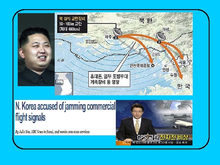
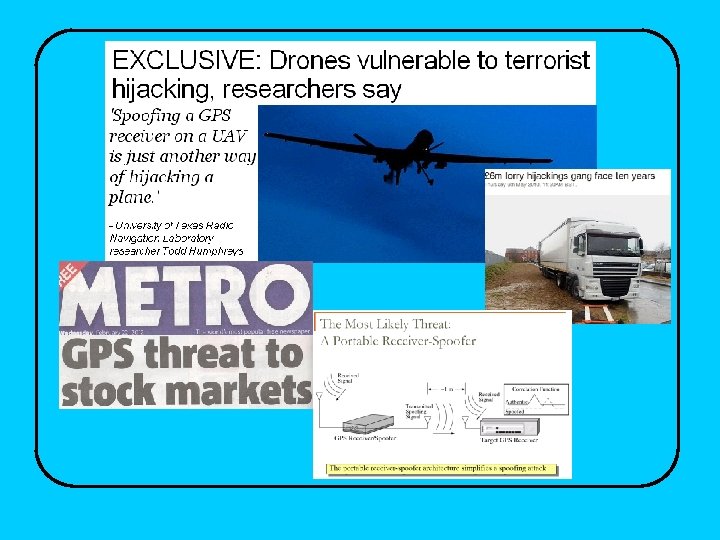
 Pictures: wikipedia. org, dailymail. co. uk, insidegnss. com, youtube. com
 e. Navigation is coming! Picture: General Lighthouse Authorities of the UK & Ireland © David Last
 Picture based on: http: //www. amcsearch. com. au
 Reduce impact of GPS vulnerability • Harden GPS systems • Complementary navigation system - independent of satellite navigation - compatible with it - meets modern standards • Enhanced Loran (e. Loran) • GNSS + e. Loran: So resilient you can reduce lighthouses and buoys – and pay for e. Loran © David Last
 The GLAs’ prototype e. Loran system is on the air Runs continuously; available since May 2010; 10 -20 m accuracy in ports with differential service (green area)
 The GLAs’ prototype e. Loran system is on the air - serving the Port of Dover and the UK section of the Dover Strait First stage e. Loran Initial Operational Capability (IOC) - soon at 6 more busy ports
 Pictures: www. poferries. com
 On 28 February 2013, the Trinity House Vessel Galatea reverted automatically to e. Loran when GPS was jammed. Galatea continued seamlessly on track, reporting e. Loran positions to nearby ships and the Vessel Traffic Service ashore. Picture: General Lighthouse Authorities of the UK & Ireland © David Last
 • e. Loran: Strong LF signals from earth • GPS:") Enhanced Loran (e. Loran) • e. Loran: Strong LF signals from earth • GPS: Weak microwaves from space • Both: timing, ranges, position, time • No common mode of failure • Plug-in replacement Pictures: Mitchell Narins, Federal Aviation Administration; Reelektronika bv © David Last
Enhanced Loran (e. Loran) • e. Loran: Strong LF signals from earth • GPS: Weak microwaves from space • Both: timing, ranges, position, time • No common mode of failure • Plug-in replacement Pictures: Mitchell Narins, Federal Aviation Administration; Reelektronika bv © David Last
 signal-in-space accuracy • Map") Differential e. Loran for Port Approaches with 10 metre (95%) signal-in-space accuracy • Map Additional Secondary Factors (ASFs) of signals • Measure real-time signal variations at Reference Station • Send corrections to receivers over e. Loran data channel
Differential e. Loran for Port Approaches with 10 metre (95%) signal-in-space accuracy • Map Additional Secondary Factors (ASFs) of signals • Measure real-time signal variations at Reference Station • Send corrections to receivers over e. Loran data channel
 Performance of the generations of Loran e. Loran has: • Data channel: differential corrections and rapid failure warnings • Advanced digital signal receivers tracking all stations in view • High precision in ports • Modern transmitting stations and procedures Table: www. gla-rrnav. org/file. html? file=652 be 60 e 268 e 09 c 0 d 91 c 5 b 6 a 976 fbc 30 © David Last
 The GLAs’ prototype e. Loran system now provides precise telecommunications timing across the UK and Ireland Picture: www. ursanav. com
 The GLAs’ prototype e. Loran system now provides precise telecommunications timing across the UK and Ireland … plus secure data, with road vehicle tracking planned. Picture: www. ursanav. com
 e. Loran can also support Land Vehicle Telematics Pictures: www. vehicletrackingltd. co. uk, www. olmc. eu, blogs. guardian. co. uk © David Last
 Timing & Data Transmissions from US Loran facilities • Renaissance of US low frequency solutions • US Coast Guard and Ursa. Nav co-operate • ‘Skyfree’ timing from Loran facility • Much faster Loran data channel • Received indoors Pictures: www. ursanav. com
 © David Last
 Japan: • No jamming has been observed in") Far East Radio Navigation Service (FERNS) Japan: • No jamming has been observed in Japan • No plans for terrestrial systems • All Loran-C stations removed by 2015 South Korea: • Plan to implement e. Loran • National coverage from 5 stations
Far East Radio Navigation Service (FERNS) Japan: • No jamming has been observed in Japan • No plans for terrestrial systems • All Loran-C stations removed by 2015 South Korea: • Plan to implement e. Loran • National coverage from 5 stations
 North-West Europe UK & Ireland: • Developing e. Loran • Implementing Operational Capability France: • Transmitting Loran-C • Has experimented with e. Loran Norway: • Closing Loran-C transmissions • Discussions with Russia re high north Netherlands: • Rotterdam pilots now using e. Loran
 The Route to e. Loran
 The Route to e. Loran Japan Germany USA? Russia ROK UK
 World-Wide Radionavigation Plan Members of IALA with Loran facilities… are encouraged to: St Germain en Laye, France • Retain them in operation • Make plans to upgrade to e. Loran • Support development of e. Loran Performance and technical standards are under development by RTCM SC 127.
 • Upgrade old Loran-C to new e. Loran • Re-use Loran-C stations • Serve shipping, telecoms, data, land transport – critical infrastructure • Maritime: positive payback, shared costs • New markets for industry • Maximise Loran-C payback