

92ef1c0848adadb6f4f44caf8e0ca169.ppt
- Количество слайдов: 61
 Data Enrichment for Adaptive Generalization from a Multiresolution Database Moritz Neun SNF-Project DEGEN 4/2004 - 4/2007 Kolloqium Geographische Informationswissenschaft - Universität Zürich, 08. 04. 2005 1
") Context DEGEN = Data Enrichment for the Control of the Generalization Process (Stefan Steiniger) & Data Enrichment for Adaptive Generalization from a Multiresolution Database (Moritz Neun) Kolloqium Geographische Informationswissenschaft - Universität Zürich, 08. 04. 2005 2
Context DEGEN = Data Enrichment for the Control of the Generalization Process (Stefan Steiniger) & Data Enrichment for Adaptive Generalization from a Multiresolution Database (Moritz Neun) Kolloqium Geographische Informationswissenschaft - Universität Zürich, 08. 04. 2005 2
 Summary 1. Introduction Slides english Präsentation deutsch 2. Data Enrichment • Defining Relations • Classifying and Modeling Relations • Extracting Relations • Representing Relations • Exploiting Relations 3. Time Table, Conferences & Publications 4. Conclusion Kolloqium Geographische Informationswissenschaft - Universität Zürich, 08. 04. 2005 3
 1. Introduction Kolloqium Geographische Informationswissenschaft - Universität Zürich, 08. 04. 2005 4
 Generalization Kolloqium Geographische Informationswissenschaft - Universität Zürich, 08. 04. 2005 5
 Generalization Kolloqium Geographische Informationswissenschaft - Universität Zürich, 08. 04. 2005 6
 Data Enrichment. . . data enrichment is necessary to equip the ”raw” spatial data with additional information which can be used for a variety of purposes within the overall generalization process: • characterization (priority, groups, relationships) • conflict detection • algorithm and parameter selection Kolloqium Geographische Informationswissenschaft - Universität Zürich, 08. 04. 2005 7
 Multiresolution ≠ Multirepresentation • Different Levels of Detail (LOD) are stored") Multiresolution Databases (MRDB) Multiresolution ≠ Multirepresentation • Different Levels of Detail (LOD) are stored in one Database. • Common for web mapping services (zooming) Important for Generalization • Objects on different LODs are linked Database Technologies • Object Oriented (e. g. Gothic) • (Object) Relational (e. g. Arc. SDE) Kolloqium Geographische Informationswissenschaft - Universität Zürich, 08. 04. 2005 8
Multiresolution Databases (MRDB) Multiresolution ≠ Multirepresentation • Different Levels of Detail (LOD) are stored in one Database. • Common for web mapping services (zooming) Important for Generalization • Objects on different LODs are linked Database Technologies • Object Oriented (e. g. Gothic) • (Object) Relational (e. g. Arc. SDE) Kolloqium Geographische Informationswissenschaft - Universität Zürich, 08. 04. 2005 8
 Thematic Maps Most research in generalization on topographic maps majority of maps are of thematic nature (categorical, GIS, facilities, networks, POI. . . ) focus on thematic maps with polygons in a generic approach Examples: geology, landuse, statistics, administration Kolloqium Geographische Informationswissenschaft - Universität Zürich, 08. 04. 2005 9
 Research Purpose The purpose of DEGEN is data enrichment, the modeling of the enriched data and the exploitation of this enriched data for generalizing thematic maps Kolloqium Geographische Informationswissenschaft - Universität Zürich, 08. 04. 2005 10
 Data Enrichment: 2. 1 Defining Relations Kolloqium Geographische Informationswissenschaft - Universität Zürich, 08. 04. 2005 11
 Definitions Relations are a kind of property defined between two modifiable object types. . . A relation can be one-to-one, one-to-many or many-to-many. . . Map Objects are the representation of a real world objects in the map data model. We distinguish simple and complex map objects (groupings). Each map object consists of its semantics (name, attributes, . . . ), its geometry and its topology. Kolloqium Geographische Informationswissenschaft - Universität Zürich, 08. 04. 2005 12
 Horizontal & Vertical Relations Horizontal relations of map objects exist within one specific scale or level of detail (LOD) and represent common structural properties. Vertical relations are links between single map objects or groups of map objects between different map scales and LODs. Kolloqium Geographische Informationswissenschaft - Universität Zürich, 08. 04. 2005 13
 Horizontal Relations Geometry Topology Structure Semantics Statistics & Density Presented last semester by Stefan Steiniger 5 groups of measures for expressing horizontal relations Kolloqium Geographische Informationswissenschaft - Universität Zürich, 08. 04. 2005 14
 • • LOD relations group") Vertical Relations map object relations identity relation (micro object) • • LOD relations group relation (meso object) changes between single map objects changes of properties for the whole LOD link map objects across different LODs enrich the links with additional information about their characteristics (properties) Kolloqium Geographische Informationswissenschaft - Universität Zürich, 08. 04. 2005 15
Vertical Relations map object relations identity relation (micro object) • • LOD relations group relation (meso object) changes between single map objects changes of properties for the whole LOD link map objects across different LODs enrich the links with additional information about their characteristics (properties) Kolloqium Geographische Informationswissenschaft - Universität Zürich, 08. 04. 2005 15
 e. g. in combination") Using Relations • Interpolation of intermediate scale levels (Cecconi 2003) e. g. in combination with morphing • Incremental updating of lower detailed LODs (Kilpeläinen and Sarjakoski 1995) • choice of appropirate algorithms • more information about parameters for algorithms • better evaluation of results • Training and use of learning algorithms (inductive, neuronal) by analyzing relations and properties (Weibel et al. 1995) • . . . Kolloqium Geographische Informationswissenschaft - Universität Zürich, 08. 04. 2005 16
Using Relations • Interpolation of intermediate scale levels (Cecconi 2003) e. g. in combination with morphing • Incremental updating of lower detailed LODs (Kilpeläinen and Sarjakoski 1995) • choice of appropirate algorithms • more information about parameters for algorithms • better evaluation of results • Training and use of learning algorithms (inductive, neuronal) by analyzing relations and properties (Weibel et al. 1995) • . . . Kolloqium Geographische Informationswissenschaft - Universität Zürich, 08. 04. 2005 16
 Working Hypothesis The integration of enriched information into a MRDB allows the use of more sophisticated generalization algorithms, accelerates adaptive generalization, and helps to determine and maintain important structures across different scale levels. This enriched information can be gained by analyzing, modeling and extracting relations between map objects. Vertical Relations, being links between map objects on two different LODs, are representing abstract knowledge about the generalization from the higher to the lower map scale. Storage of Relations Classification of Relations Modeling of Relations Extraction of Relations Exploitation of Relations Kolloqium Geographische Informationswissenschaft - Universität Zürich, 08. 04. 2005 17
 Research Questions • • • What types of “vertical” relations between map objects on different levels of detail can be established? How can these relations effectively be modelled and represented in a multiresolution database? How can the map objects in two levels of detail be matched and the enriching relations and their attributes be gained? How can the relations and the matching process be managed and the relations be deployed? Can these vertical relations be used for the creation of intermediate levels of details? Can the same relations also be used for incremental Generalization? Kolloqium Geographische Informationswissenschaft - Universität Zürich, 08. 04. 2005 18
 2. 2 Classifying and Modeling Relations Storage of Relations Classification of Relations Modeling of Relations Extraction of Relations Exploitation of Relations Kolloqium Geographische Informationswissenschaft - Universität Zürich, 08. 04. 2005 19
 LOD relations group relation (meso object)") Vertical Relations map-object relations identity relation (micro object) LOD relations group relation (meso object) procedural knowledege is bound to algorithm & scale vertical relations = abstract knowledge express the geometrical, topological and semantical outcome formalize the outcome by parameterizing abstract generalization operators Kolloqium Geographische Informationswissenschaft - Universität Zürich, 08. 04. 2005 20
Vertical Relations map-object relations identity relation (micro object) LOD relations group relation (meso object) procedural knowledege is bound to algorithm & scale vertical relations = abstract knowledge express the geometrical, topological and semantical outcome formalize the outcome by parameterizing abstract generalization operators Kolloqium Geographische Informationswissenschaft - Universität Zürich, 08. 04. 2005 20
 LOD") Vertical Relations vertical relations map object relations identity relation 1: 1 (micro object) LOD relations group relation n: m (meso object) structural semantic simplification * aggregation * (alignment, cluster) similarity neigbourhood matrix smoothing * amalgamation * (cluster) legend diversity enlargement * typification * (cluster, alignment) type priorities configuration exaggeration * partitioning * (through e. g. alignments) causal & logic collapse * symbolization * displacement * Kolloqium Geographische Informationswissenschaft - Universität Zürich, 08. 04. 2005 21
Vertical Relations vertical relations map object relations identity relation 1: 1 (micro object) LOD relations group relation n: m (meso object) structural semantic simplification * aggregation * (alignment, cluster) similarity neigbourhood matrix smoothing * amalgamation * (cluster) legend diversity enlargement * typification * (cluster, alignment) type priorities configuration exaggeration * partitioning * (through e. g. alignments) causal & logic collapse * symbolization * displacement * Kolloqium Geographische Informationswissenschaft - Universität Zürich, 08. 04. 2005 21
 Vertical Identity Relations 1: 1 simplification smoothing enlargement exaggeration Kolloqium Geographische Informationswissenschaft - Universität Zürich, 08. 04. 2005 22
 Vertical Identity Relations 1: 1 collapse symbolization displacement Kolloqium Geographische Informationswissenschaft - Universität Zürich, 08. 04. 2005 23
 Vertical Group Relations n: m aggregation Kolloqium Geographische Informationswissenschaft - Universität Zürich, 08. 04. 2005 24
 Vertical Group Relations n: m amalgamation typification Kolloqium Geographische Informationswissenschaft - Universität Zürich, 08. 04. 2005 25
 Relation Properties relation properties semantic properties geometric properties topological properties statistics size / position neigbourhood resistance / attraction shape intersection type configuration (island, landscape) orientation structure containment (in, ring model) type change originator threshold level color codes for properties: valid for identity relations valid for group relations valid for all relations Kolloqium Geographische Informationswissenschaft - Universität Zürich, 08. 04. 2005 26
 Orientation, meso structure Kolloqium") Relation Properties Topology, compactness Frequency, distance, size Inter-thematic (river soil) Orientation, meso structure Kolloqium Geographische Informationswissenschaft - Universität Zürich, 08. 04. 2005 27
Relation Properties Topology, compactness Frequency, distance, size Inter-thematic (river soil) Orientation, meso structure Kolloqium Geographische Informationswissenschaft - Universität Zürich, 08. 04. 2005 27
 2. 3 Extracting Relations Storage of Relations Classification of Relations Modeling of Relations Extraction of Relations Exploitation of Relations Kolloqium Geographische Informationswissenschaft - Universität Zürich, 08. 04. 2005 28
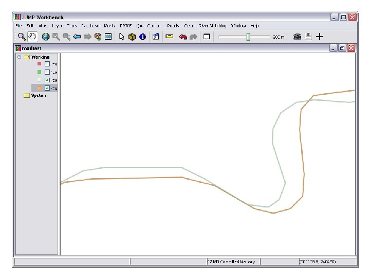
 Matching 1: 25‘ 000 Kolloqium Geographische Informationswissenschaft - Universität Zürich, 08. 04. 2005 1: 200‘ 000 29
 Matching The main possibilities of the matching process: • semantic matching (e. g. by object name or identifier) • geometric matching (e. g. by location, size, surface description) • topological matching (e. g. overlaps, neigbourhoods) Kolloqium Geographische Informationswissenschaft - Universität Zürich, 08. 04. 2005 30
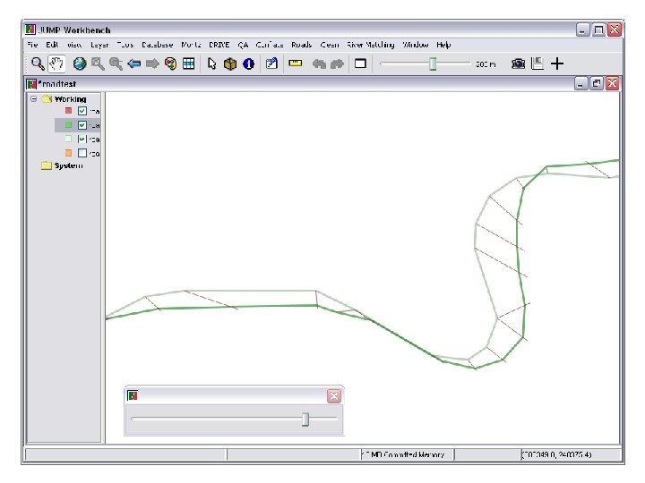
 Matching – Properties Kolloqium Geographische Informationswissenschaft - Universität Zürich, 08. 04. 2005 31
 2. 4 Storing & Representing Relations Storage of Relations Classification of Relations Modeling of Relations Extraction of Relations Exploitation of Relations Kolloqium Geographische Informationswissenschaft - Universität Zürich, 08. 04. 2005 32
 Storing & Representing Relations How to … • represent and store the vertical relations in a MRDB (relation objects, attributes …)? • represent identity, group relations and special cases? • establish links to the horizontal relations (Stefan Steiniger)? • represent interdependencies with horizontal relations? • make the relations (as support service) available to others? tree structure ? Kolloqium Geographische Informationswissenschaft - Universität Zürich, 08. 04. 2005 33
 Current MRDB approaches usually work with strictly hierarchical") Representing Relations directed acyclic graph (DAG) Current MRDB approaches usually work with strictly hierarchical data structures such as aggregation trees not flexible enough evaluation of non-taxonomic and partonomic relations Database technology: OODBMS vs. RDBMS elegance vs. performance ? RDBMS OODBMS from www. gitta. info Kolloqium Geographische Informationswissenschaft - Universität Zürich, 08. 04. 2005 34
Representing Relations directed acyclic graph (DAG) Current MRDB approaches usually work with strictly hierarchical data structures such as aggregation trees not flexible enough evaluation of non-taxonomic and partonomic relations Database technology: OODBMS vs. RDBMS elegance vs. performance ? RDBMS OODBMS from www. gitta. info Kolloqium Geographische Informationswissenschaft - Universität Zürich, 08. 04. 2005 34
 Managing and Deploying Relations Open Generalization Platform with Web-Services technology Auto-Carto 2005 Kolloqium Geographische Informationswissenschaft - Universität Zürich, 08. 04. 2005 35
 Application scenarios Web Feature Service Generalization Service http: // GEO Database Web GIS, map production Map Generalization platform Middleware solution Service • • • Generalization/ Browser GIS Client Service clustering allows real time services of symbolized foreground objects standalone generalization typification (e. g. pointssolution, generalization service as toolbox interactive of interest) applicationsfor - adaptive zooming for web mapping practicable complex generalization - dynamic mapping for mobile applications applicable in advance, e. g. semi automated update limits: only applicable for simple generalization operations Auto-Carto 2005 Kolloqium Geographische Informationswissenschaft - Universität Zürich, 08. 04. 2005 36
 Open Research Platform map production • possibility for small companies to offer generalization solutions, new business models • customers can keep their production lines open research platform for generalization • allows techniques and code to be shared • supports benchmarks and comparison of different implementation • complex generalization task like orchestration of generalization operators can be addressed • at the last meetings of “ICA Commission on Map Generalization and Multiple Representation” (Paris 2003 and Leicester 2004) University Zurich got responsibility to bring forward the idea of a common open research platform for generalization Auto-Carto 2005 Kolloqium Geographische Informationswissenschaft - Universität Zürich, 08. 04. 2005 37
 Open Research Platform Registry for Generalization Services Generic XML Interface Descriptions Auto-Carto 2005 Kolloqium Geographische Informationswissenschaft - Universität Zürich, 08. 04. 2005 38
 2. 5 Exploiting Relations Storage of Relations Classification of Relations Modeling of Relations Extraction of Relations Exploitation of Relations Kolloqium Geographische Informationswissenschaft - Universität Zürich, 08. 04. 2005 39
 • incremental generalization") Exploiting Relations • interpolation of intermediate scale levels (e. g. Morphing) • incremental generalization and updating • . . . Kolloqium Geographische Informationswissenschaft - Universität Zürich, 08. 04. 2005 40
Exploiting Relations • interpolation of intermediate scale levels (e. g. Morphing) • incremental generalization and updating • . . . Kolloqium Geographische Informationswissenschaft - Universität Zürich, 08. 04. 2005 40
 Morphing of single points along linear or weighted transformation paths: • Every point in LOD 1 has a transformation path to the final point in LOD 2 • The intermediate point is created by simple interpolation along the transformation path • Interpolation can be realized directly in the database (stored procedures) Kolloqium Geographische Informationswissenschaft - Universität Zürich, 08. 04. 2005 41


 Morphing Combining vector morphing with scaleless storage of the geometry. Kolloqium Geographische Informationswissenschaft - Universität Zürich, 08. 04. 2005 54
 Time Table, Conferences & Publications Kolloqium Geographische Informationswissenschaft - Universität Zürich, 08. 04. 2005 55
 Conferences & Publications • ICA Workshop 2004: Neun, M. , R. Weibel and D. Burghardt, Data Enrichment for Adaptive Generalisation • Auto-Carto 2005: Burghardt, D. , M. Neun and R. Weibel, Generalization Services on the Web – A Classification and an Initial Prototype Implementation • ICA Book 2005: Edwardes, A. , D. Burghardt and M. Neun, Experiments to build an open generalisation system also in a Ca. GIS Special Issue • ISGI Symposium 2005: Edwardes, A. , D. Burghardt and M. Neun, Interoperability in Map Generalisation Research • ICA Workshop 2005: Neun, M. and D. Burghardt, Web Services for an Open Generalisation Research Platform • ICA Conference 2005: Neun, M. and S. Steiniger, Modelling Relations for Categorical Maps Kolloqium Geographische Informationswissenschaft - Universität Zürich, 08. 04. 2005 56
 Time Table Kolloqium Geographische Informationswissenschaft - Universität Zürich, 08. 04. 2005 57
 Conclusion Kolloqium Geographische Informationswissenschaft - Universität Zürich, 08. 04. 2005 58
 Conclusion Purpose: • • • data enrichment modeling of enriched data exploitation of enriched data Focus: • thematic vector maps Goals/Questions: • types of “vertical” relations between map objects on different LODs? • modelling and representing in a MRDB? • matching of map objects in two LODs and acquisition relations and their attributes? • management and deployment of relations? • usefulness of vertical relations for the creation of intermediate LODs? • usefulness of the same relations for incremental generalization? Kolloqium Geographische Informationswissenschaft - Universität Zürich, 08. 04. 2005 59
 Integration") Thanks for your attention! Any questions, suggestions or comments? Bibliography: Cecconi, A. (2003) Integration of Cartographic Generalization and Multi-Scale Databases for Enhanced Web Mapping Galanda, M. (2003) Automated Polygon Generalization in a Multi Agent System Kilpelainen, T. and T. Sarjakoski (1995) Incremental Generalization for Multiple Representations of Geographical Objects Ruas, A. (1999) Modèle de généralisation de données géographiques à base de contraintes et d‘autonomie Weibel, R. , S. Keller and T. Reichenbacher (1995) Overcoming the Knowledge Acquisition Bottleneck in Map Generalization: The Role of Interactive Systems and Computational Intelligence. Kolloqium Geographische Informationswissenschaft - Universität Zürich, 08. 04. 2005 60
Thanks for your attention! Any questions, suggestions or comments? Bibliography: Cecconi, A. (2003) Integration of Cartographic Generalization and Multi-Scale Databases for Enhanced Web Mapping Galanda, M. (2003) Automated Polygon Generalization in a Multi Agent System Kilpelainen, T. and T. Sarjakoski (1995) Incremental Generalization for Multiple Representations of Geographical Objects Ruas, A. (1999) Modèle de généralisation de données géographiques à base de contraintes et d‘autonomie Weibel, R. , S. Keller and T. Reichenbacher (1995) Overcoming the Knowledge Acquisition Bottleneck in Map Generalization: The Role of Interactive Systems and Computational Intelligence. Kolloqium Geographische Informationswissenschaft - Universität Zürich, 08. 04. 2005 60
, Geometry Change in Model Generalization –") Full Bibliography Bobzien, M. and D. Morgenstern (2002), Geometry Change in Model Generalization – A Geometrical or a Topological Problem Kilpelainen, T. , Sarjakoski, T. Incremental Generalization for Multiple Representations of Geographical Objects. In Muller, J. C. , Lagrange, J. P. , Weibel, R. (editors) GIS and Generalization: Methodology and Practice, Taylor & Francis, 1995. Weibel, R. , S. Keller and T. Reichenbacher (1995). Overcoming the Knowledge Acquisition Bottleneck in Map Generalization: The Role of Interactive Systems and Computational Intelligence. In: Frank, A. U. ; Kuhn, W. (eds. ): Spatial Information Theory: A Theoretical Basis for GIS. Lecture Notes on Computer Science, Berlin: Springer-Verlag, Vol 988: pp. 139 -156 Kolloqium Geographische Informationswissenschaft - Universität Zürich, 08. 04. 2005 61
Full Bibliography Bobzien, M. and D. Morgenstern (2002), Geometry Change in Model Generalization – A Geometrical or a Topological Problem Kilpelainen, T. , Sarjakoski, T. Incremental Generalization for Multiple Representations of Geographical Objects. In Muller, J. C. , Lagrange, J. P. , Weibel, R. (editors) GIS and Generalization: Methodology and Practice, Taylor & Francis, 1995. Weibel, R. , S. Keller and T. Reichenbacher (1995). Overcoming the Knowledge Acquisition Bottleneck in Map Generalization: The Role of Interactive Systems and Computational Intelligence. In: Frank, A. U. ; Kuhn, W. (eds. ): Spatial Information Theory: A Theoretical Basis for GIS. Lecture Notes on Computer Science, Berlin: Springer-Verlag, Vol 988: pp. 139 -156 Kolloqium Geographische Informationswissenschaft - Universität Zürich, 08. 04. 2005 61