d4732ff76f9dd7db58fba08ec08175d6.ppt
- Количество слайдов: 22


Creating a bigger, better, brighter future LGMA NSW General Managers & Directors Convention and Workshop 25 November 2011 Peter Goddard– Executive Manger LPI
 is now part of the Department of")
Overview • Land & Property Information (LPI) is now part of the Department of Finance and Services • Relationship strengthened through Mo. Us • Spatial data exchange with local government • Daily transactional updates • Local government spatial data working groups • NSW Comprehensive Property Addressing System (CPAS)

Building Partnership with Local Government Rates DA Approvals LPI Valuations & Notice of Sale Address data E-planning (With Do. P) Surveys Plan Registration & Titles Local cadastre Survey Control Environmental/ Planning State cadastre Local Emergency Management Spatial group Topographic/ Image Data Emergency information CS 2 i (Spatial Council)

SIX - Spatial Clearinghouse

SIX Components • The Spatial Information e. Xchange is a cross government initiative to spatially enable NSW. • It is a web based web portal that can: – Take you to any location in NSW – Show Information about that location – Inform you with relevant details on that location • Spatial Data Infrastructure – SDI
 • Agreement to work together to:")
Relationship strengthened through Memorandum Of Understanding (Mo. U) • Agreement to work together to: • reduce duplication • improve the quality of spatial data and • facilitate reciprocal exchange of data • Supported by a Products and Services Agreement (PSA) and associated Specifications of data to be exchanged • 120 Councils have signed a Mo. U • All councils have received a copy of the Mo. U and are encouraged to sign

Sydney-Wollongong-Newcastle Autumn 2011 epoch
")
Spatial data exchange - Incremental updates • Available for; • Digital Cadastral Database (DCDB) • Digital Topographic Database (DTDB) • Geo-coded Urban and Rural Address System (GURAS) – under test • Applications available to suit all councils’ systems • Seventy Councils (79 organisations in total) take DCDB incremental updates • Provide more timely and accurate spatial data and minimises duplication of maintenance efforts

Spatial data exchange - DCDB upgrade • Collaborative arrangements with local councils to improve the quality of the local cadastral (mapping) fabric based on requests from local councils • Additional survey control required • 10 cm imagery added to program • Alternate strategy • Target population centres with existing survey control • 10 cm imagery available or on program • Other towns as control & imagery become available

Spatial data exchange - Imagery • Regional NSW • High resolution digital imagery • 50 cm Ground Sample Distance (GSD) standard • 10 cm GSD in some towns (facilitates DCDB Upgrade) • Sydney-Wollongong-Newcastle by RFQ • Autumn epoch recently acquired (Sydney - Wollongong) • Aiming for Spring & Autumn each year • Spring acquisition RFQ in planning • Collective, Whole of Government purchase • Require seven agencies (whole area) contribution • Cost to LG - ~$5/tile (ex GST)

Sydney-Wollongong-Newcastle Autumn 2011 epoch
 – Underpins the state’s")
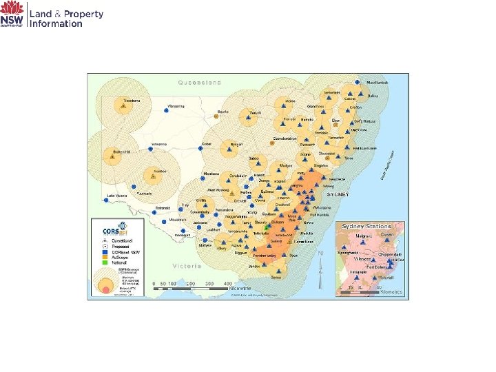
Other Spatial Initiatives • Survey Control Information Management System (SCIMS) – Underpins the state’s survey control network • Cadastral upgrade – Improving the NSW spatial data infrastructure • Aerial imagery and Li. DAR – Rolling programs • Continuously Operating Reference Stations (CORS) – Providing real-time spatial accuracy

NSW Location Leadership Group • Peak Spatial Body in NSW – Representatives from key agencies and Local Government • Presently working on Location Strategy – Strategic input into spatial issues for Government and Local Government

NSW Location Leadership Group – Working Groups • • • Emergency Services Water Addressing Local Government Imagery Spatial Information Management Framework (Metadata)
 Cadastral")
Local Government working groups • • Cadastral Delivery - Lisa Mc. Farlane (Wollondilly) Cadastral Upgrade – Thomas Baxter (Tamworth) Addressing - Steve Heapy (Sutherland) Information Interchange (SIX) - Paul Middleton (Eurobodalla) Crown Land - Carl Bennett (Port Macquarie) Imagery/Li. DAR - Natalie Bennett (Wellington) Licensing/IP/Copyright - Scott Newman (Tweed) Metadata - Michael Troth (Geospatial Alliance, Junee)

Why does NSW need a Comprehensive Property Addressing System? • The legislation and process for creating and distributing addresses does not support a clear, comprehensive, collaborative approach • There is no single source of truth or central repository of official or trusted address information for NSW • There is no governing body to assist and support Councils in rectifying inaccurate or ambiguous address information which poses a real risk to both Councils and the community • There are many different ways in which address information is created and distributed

The CPAS Program objectives • Legislative reform to provide for more efficient and accurate address creation and distribution in NSW • Implementation of National Address Management Framework (NAMF) compliant processes • The provision of more effective governance and support by modifying the role of the GNB to specifically include addressing matters • The creation of a central, comprehensive, official geo-coded address database for NSW • A stock take of Rural Addressing and the development and implementation of a collaborative strategy for its completion and ongoing maintenance

What’s in CPAS for councils and the community? • Maximised value of the trusted and authoritative address information created by Councils • Support for the community and industry through increased efficiency and effectiveness of emergency services, post and utility services • Rapid identification of address locations including alias and vanity addresses • Improved efficiency through a streamlined process for naming roads and automated two-way web distribution and notification services • Single ‘source of truth’ address database which accurately represents all addresses • Improved address search and validation services • Property Address Confirmation Certificate to encourage the use of correct addresses • Legislative reform along with a centralised distribution centre will mitigate the risks associated with inadequate addressing for Council and the community

Heritage Valuations • Land subject to heritage restrictions is given a discounted land value • Court decision in April 2011 threw doubt on this method • The VG has lodged an appeal • An Amendment to section 14 G of the Valuation of Land Act passed through both houses of Parliament this week reconfirming the current methodology

Land Value Verification Program • Ombudsman’s review in 2005 established a program • The 2006 -11 program is coming to an end • From 2012 the VG has authorised a revised program of land value verification for: • Verification based on risk rating • Verification with frequency based on risk • Specification of the due diligence activities

Thank You Peter Goddard Executive Manager Land Property Information 9228 6659 Peter. goddard@lpi. nsw. gov. au
d4732ff76f9dd7db58fba08ec08175d6.ppt