d6167fb533bcaa494921f85ac5cc14ea.ppt
- Количество слайдов: 152
 COORDINATE SYSTEMS IN GEODESY Doç. Dr. Ersoy ARSLAN
 1 - INTRODUCTION • • • These notes discuss the precise definitions of, and transformations between, the coordinate systems to which coordinates of stations on or above the surface of the earth are referred. To define a coordinate system we must specify: a) the location of the origin, b) the orientation of the three axes, c) the parameters (Cartesian, curvilinear) which define the position of a point referred to the coordinate system.
 • The earth has two different periodic motions in space. It rotates about its axis, and it revolves about the sun (see Figure 1 -1). There is also one natural satellite (the moon) and many artificial satellites, which have a third periodic motion in space: orbital motion about the earth. These periodic motions are fundamental to the definition of systems of coordinates and systems of time.
 • Terrestrial coordinate systems are earth fixed and rotate with • • the earth. They are used to define the coordinates of points on the surface of the earth. There are two kinds of terrestrial systems called geocentric systems and topocentric systems (see Figure 1 -2). Celestial coordinate systems do not revolve but may rotate with the earth. They are used to define the coordinates of celestial bodies such as stars. There are four different celestial systems, called the ecliptic, right ascension, hour angle, and horizon systems. The orbital system does not rotate with the earth, but revolves with it. It is used to define the coordinates of satellites orbiting around the earth.
 1. 1 POLES, PLANES AND AXES • The orientation of axes of coordinate systems can be • • described in terms of primary and secondary poles, primary and secondary planes, and primary, secondary and tertiary axes. The primary pole is the axis of symmetry of the coordinate system, for example the rotation axis of the earth. The primary plane is the plane perpendicular to the primary pole, for example the earth's equatorial plane. The secondary plane is perpendicular to the primary plane and contains the primary pole. It sometimes must be chosen arbitrarily, for example the Greenwich meridian plane, and sometimes arises naturally, for example the equinoctial plane. The secondary pole is the intersection of the primary and secondary planes. The primary axis is the secondary pole.
 • The tertiary axis is the primary pole. The secondary axis is perpendicular to the other two axes, chosen in the direction, which makes the coordinate system either right-handed or left-handed as specified. • We will use either the primary plane or the primary pole, and the primary axis to specify the orientation of each of the coordinate systems named above.
 The tertiary axis Z, X 3 or 3. axis The primary pole The rotation axis of the earth The secondary plane The secondary axis The Greenwich meridian plane (for-left-handed system) Y, X 2 or 2. axis The secondary axis Primary plane Earth’s equatorial Plane The primary axis (for right-handed system) Y, X 2 or 2. axis X, X 1 or 1. axis The secondary pole Figure 1. 3 - Poles, planes and axes
 1. 2 SUMMARY OF REFLECTION AND ROTATION MATRICES 1. 2. 1 Orthogonal Transformations The matrix equation • Y=AX where A is a matrix and X and Y are column vectors, can be regarded as a linear transformation, in which case the matrix A is called the transformation matrix. If the two vectors X and Y have the same length, then both the transformation and the matrix are said to be orthogonal. Orthogonal matrices have the property that the product of the matrix and its transpose (or vice versa) is the identity matrix, that is • AT A = A AT = I.
 • From this property it follows that the determinant of an • orthogonal matrix is either +1 or -l. There are two kinds of orthogonal transformations called reflections and rotations. The determinant of reflection matrices is -1, and the determinant of rotation matrices is +1. There are two interpretations of the linear transformation above. The first is that the transformation describes the relationship between two coordinate systems, in which case X and Y are the same vector, but their elements refer to the two different systems. The second is that the transformation describes the relationship between different vectors X and Y in the same coordinate system. In these notes, we are interested only in the first interpretation.
 1. 2. 2 Right and Left Handed Cartesian Coordinate Systems • A three dimensional Cartesian coordinate system can be orthogonally transformed in only six different ways. It can be rotated about each of its axes. Each of its axes can be reflected. In such a coordinate system, the vectors X and Y will have only three elements. Let us define the axis to which the first, second, and third elements of X and Y are referred as the 1 -axis, 2 -axis, and 3 -axis respectively (we could equally well label them the xl, x 2, x 3 axes or x, y, z axes).
 • These three axes may define either a right-handed or a left-handed coordinate system. Right handed systems follow the right hand rule: if the fingers of the right hand are curled around any axis so that the thumb points in the positive direction, then the fingers will point from a second axis to the third axis, numbered in cyclic fashion. Grasping the 1 -axis, the fingers point from the 2 -axis to the 3 -axis. Grasping the 2 -axis, the fingers point from the 3 -axis to the 1 -axis. Grasping the 3 -axis, the fingers point from the 1 -axis to the 2 -axis. Left-handed coordinate systems follow the left hand rule, which differs from the above only in that the left hand is used.

 Z Z O X Figure 1. 4 a- Rigth-handed system Y Y O X Figure 1. 4 b- Left-handed system
 • 1. 2. 3 Reflections • If we denote a reflection of the kth axis by Pk , then the following expressions define three reflection matrices: ; ; (2. 3) • Note that reflection matrices commute (e. g. P 2 P 3 = P 3 P 2), so that it makes no difference in what order a sequence of reflections are performed. Note also that an odd number of reflections changes the handedness of the coordinate system.
 • Rotations • In a Cartesian coordinate system with the axes x, y, z the position of a point P is determined by its position vector (2. 5) • x. P, y. P, z. P are real numbers (Fig. 1. 5).
 Figure 1. 5 - Cartesian coordinate system
 • If we denote a rotation of angle about the 1 st axis by R 1( ), a rotation of angle about the 2 nd axis by R 2( ), and a rotation of angle about the 3 rd axis by R 3( ), then the following expressions define three rotation matrices:
 • Note that rotation matrices do not commute. The product of several rotations is performed from right to left, for example in R 1( ) R 2( ) R 3( ), the rotations are performed about the 3 -axis of the original system, the 2 -axis of the transformed system, and the 1 -axis of the doubly transformed system, to yield the final triply transformed system.
 • The transformation to a second Cartesian coordinate • system with identical origin and the axes x’, y’, z’, which is generated from the first one by a rotation around the z -axis by the angle , can be realized through the matrix operation X P = R 3 ( ) X P (2. 7) The representation is valid for a right-handed coordinate system. When viewed towards the origin, a counterclockwise rotation is positive. Any coordinate transformation can be realized through a combination of rotations. The complete transformation is XP = R 1( ) R 2( ) R 3( ) XP (2. 8)
 • Finally, the matrix for a general rotation by the angles , , is R = R 1 ( ) R 2 ( ) R 3 ( ) (2. 9) • The relation between the position vectors in two • arbitrarily rotated coordinate systems is then XP = R XP ; XP = RT XP (2. 10)
 In geodesy the rotation angles are often very small, thus allowing the use of the linearized form for R. With cos 1 and sin (in radians), neglecting higher order terms, it follows that (2. 11) If the rotation angles are all so small that their cosines can be assumed to be unity, then the rotation matrices become commutative. This is the case for differential rotations, for example.
 • The above expressions define positive rotations, which are right-hand rotations for right-handed coordinate systems and left-hand rotations for left-handed coordinate systems. A right-hand rotation is related to the right hand rule given above: if the fingers of the right hand are curled around the rotation axis so that the thumb points in the positive direction, then the fingers curl in the direction of a right hand rotation. A similar statement for left hand rotations is obvious.
 1. 2. 5 Inverse Transformations • The inverse of a transformation A (denoted A-1) is the • • transformation which returns conditions to their original state, that is A-1 A = A A-1 = I. Reflections are self-inverse, that is Pk P k = I Common sense tells us that the inverse of a positive rotation is a negative rotation, that is and this conclusion is verified by taking the orthogonal property AT A = I from which it is evident that for orthogonal matrices A-1 = AT
 and for each of the above expressions for rotation matrices it can be shown that • Applying the rule for the inverse of products [A B]-1 = B-1 A-1 we have • A product transformation consisting of one rotation and one reflection commutes only if the rotation and reflection refer to the same axis, that is Pj Rk = Rk Pj if j = k otherwise Pj Rk = Rk-1 Pj if j k.
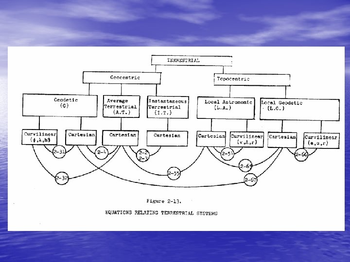
 . 2 TERRESTRIAL COORDINATE SYSTEMS • In this chapter we will discuss terrestrial geocentric and terrestrial topocentric coordinate systems. • We first discuss terrestrial geocentric systems using only Cartesian coordinates, and considering in detail what is meant by "the earth's axis of rotation" and "the Greenwich meridian". Then the relationship between Cartesian and curvilinear coordinates is described. Geodetic datums are discussed. Finally terrestrial topocentric systems are considered, with attention paid to what is meant by "the surface of the earth".
 2. 1 TERRESTRIAL GEOCENTRIC SYSTEMS • • In the introduction it was stated that for terrestrial geocentric systems: a) the origin is near the centre of the earth, b) the primary pole is aligned to the earth's axis of rotation, c) the primary axis is the intersection between the primary plane and the plane containing the Greenwich meridian, d) the systems are right-handed. • The last specification is unambiguous. As we shall see the other three are not. We will first discuss problems in defining the earth's axis of rotation and the Greenwich meridian. Then we will discuss translations of the origin from the centre of the earth.
 2. 1. 1 Polar Motion and Irregular Rotation of the Earth • We think of the earth as rotating about a fixed axis at a • • uniform rate. In fact, the axis is not fixed and the rate is not uniform. Over 80 years ago, it was discovered that the direction of the earth's rotation axis moves with respect to the earth's surface. This polar motion is principally due to the fact that the earth's axes of rotation and maximum inertia do not coincide. The resultant motion is irregular but more or less circular and counterclockwise (when viewed from North), with an amplitude of about 5 meters and a main period of 430 days (called the Chandler period). The earth rotation parameters cannot be described through theory but must be determined through actual observations by the international time and latitude services. For the last 80 years, or so, these services were based mainly on astronomical observations.
 • Two international organizations, the International Polar Motion Service (IPMS) and the Bureau International de 1'Heure (BIH) routinely measured this motion through astronomic observations; the IPMS from five stations at the same latitude, and the BIH from about 40 stations scattered worldwide. The results were published as the coordinates of the true rotation axis with respect to a reference point called the Conventional International Origin (CIO) which is the average position of the rotation axis during the years 1900 -1905, Figure 2 -1 shows the polar motion during 1969 as determined by IPMS and BIH. • On January 1, 1988 the International Earth Rotation Service (IERS) took over this task. The principle observation techniques now used are Laser ranging to satellites and to the moon and Very Long Baseline Interferometry (VLBI).
 İstasyon Carloforte, İtalya Gaitehersburg, Maryland. ABD Kitab, Özbekistan, (eski USSR) Mizusawa, Japonya Ukiah, California- ABD Boylam Enlem 8 18 44 39 08 08. 941 -77 11 57 39 08 13. 202 66 52 51 39 08 01. 850 141 07 51 39 08 03. 602 -123 12 35 39 08 12. 096

 Şekil 2. 6 - Kutup hareketi


 Tablo 2. 3 Kasım-Aralık 1990 için kutup hareketi parametreleri POLE COORDINATES, UT 1 -UTC, AND GPS-UTC FROM BIH, CIRCULAR B ------------------------------------MJD X-POLE Y-POLE UT 1 -UTC GPS-UTC DATE REMARKS (") (S) 48199. 0. 2260 0. 1371 -0. 25656 6. 90 11 4 DEF 48204. 0. 2073 0. 1253 -0. 26741 6. 90 11 9 DEF 48209. 0. 1928 0. 1138 -0. 27872 6. 90 11 14 DEF 48214. 0. 1777 0. 1044 -0. 28971 6. 90 11 19 DEF 48219. 0. 1623 0. 0963 -0. 30094 6. 90 11 24 DEF 48224. 0. 1436 0. 0900 -0. 31241 6. 90 11 29 DEF 48229. 0. 1251 0. 0845 -0. 32413 6. 90 12 4 DEF 48234. 0. 1073 0. 0799 -0. 33518 6. 90 12 9 DEF 48239. 0. 0904 0. 0747 -0. 34529 6. 90 12 14 DEF 48244. 0. 0737 0. 0698 -0. 35502 6. 90 12 19 DEF 48249. 0. 0550 0. 0678 -0. 36508 6. 90 12 24 DEF 48254. 0. 0346 0. 0681 -0. 37551 6. 90 12 29 DEF
 • Over 40 years ago irregularities in the rotation of the earth • were discovered (other than polar motion). There are three types of irregularities: seasonal variations probably due to meteorological changes or earth tides; secular decrease due to tidal friction; and irregular fluctuations. The seasonal variation is the only one of these presently being taken into account, and it is more or less reproducible from year to year, and produces a displacement along the equator of up to 15 meters with respect to a point rotating uniformly. throughout the year (see Figure 2 -2). Because of this seasonal variation, the Greenwich meridian (the plane containig the earth's rotation axis and the center of the transit instrument at Greenwich Observatory) does not rotate uniformly. A fictitious zero meridian which does rotate uniformly (so far as the effects of polar motion and seasonal variations are concerned) is called the Mean Observatory or Greenwich mean astronomic meridian. Its location was defined by the BIH.
 • The mean Greenwich meridian; also named the Greenwich • Mean Observatory (GMO) is defined through the nominal longitudes of all observatories which contributed to the former international time service (Bureau International de l`Heure (BIH)). Because of the inclusion of new satellite observation techniques and additional stations for the determination of time and pole coordinates during the last decade, this definition was no longer valid in a rigorous sense. It was put on a broader foundation with the introduction of the new International Earth Rotation Service (IERS). In future, the CTS will be defined by a global network of fundamental stations whose coordinates are determined by the most precise observation techniques. Coordinate changes, caused by recent crustal movement, are also considered. In 1984 the Bureau International de 1`Heure (BIH) introduced such a terrestrial reference system, named BTS (BIH Terrestrial System), and this system is now maintained as the IERS Terrestrial Reference Frame (ITRF).
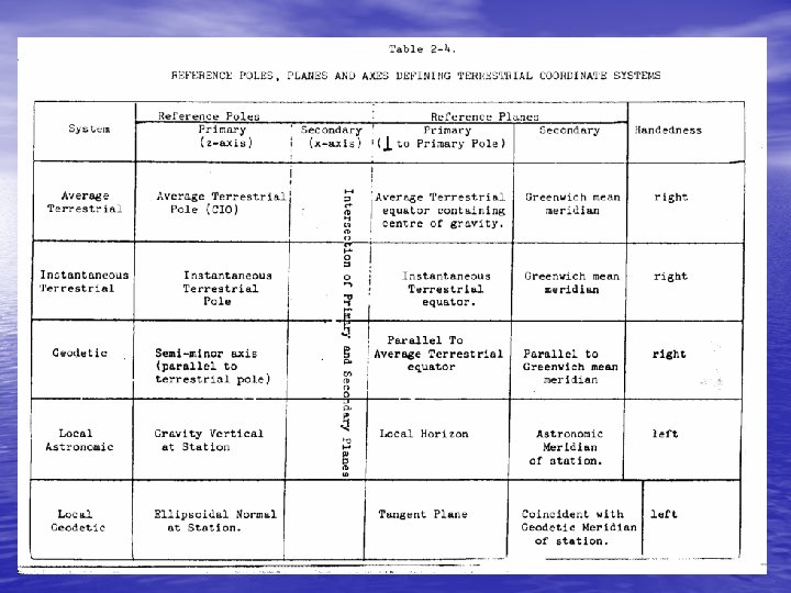
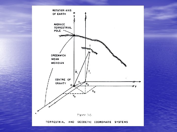
 2. 1. 2 Average and Instantaneous Terrestrial Systems • • The average terrestrial (A. T. ) system is the ideal world geodetic coordinate system (see Figure 2 -3): a) Its origin is at the centre of gravity of the earth. b) Its primary pole is directed towards the CIO (the average north pole of 1900 -1905), and its primary plane is the plane perpendicular to the primary pole and containing the earth's center of gravity (the average equatorial plane). c) Its secondary plane is the plane containing the primary pole and the Mean Observatory. The intersection of these two planes is the secondary pole, or primary axis. d) It is a right-handed system.

 • We can then define the position vector Ri of a terrain point i in terms of its Cartesian coordinates x, y, z as 2 -1 Figure 2. 3 a – Average Terrestrial Coordinate System
 The instantaneous terrestrial (I. T. ) system is specified as follows: • a) Its origin is at the centre of gravity of the earth. • b) Its primary pole is directed towards the true • (instantaneous) rotation axis of the earth. c) Its primary axis is the intersection of the primary plane and the plane containing the true rotation axis and the Mean Observatory. • d) It is a right-handed system.

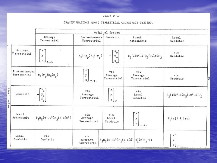
 • The main characteristic of these two systems is that they • are geocentric systems having their origins at the centre of gravity of the earth and the rotation axis of the earth as the primary pole. By means of rotation matrices the coordinates of a point referred to the instantaneous terrestrial system are transformed into the average system by the following equation (see Figure 2 -4): 2 -2

 • where (x. P , y. P ) are expressed in arcseconds, and the rotation matrices are a clockwise (negative) rotation about the x axis, and a clockwise (negative) rotation about the y-axis,

 The inverse is and because of the orthogonal characteristic of rotation matrices, that is R-1( ) = RT( ) = R(- ) 2 -3
 • Astronomik gözlemlerle bulunan kutupsal anlık koordinatlar astronomik enlem, astronomik boylam ve astronomik azimut yine kutup hareketi parametrelerine göre düzeltilerek ortalama kutuba indiregenmiş koordinatlar elde edilir. Bu indirgemeler eşitlikleri ile hesaplanır. Eşitliklerde T (T ölçme anındaki) anlık kutba göre yapılan astronomik gözlemelerle belirlenmiş anlık astronomik azimut, T anlık astronomik enlem, T anlık astronomik boylam, ortalama kutba (CIO) indirgenmiş astronomik azimut, indirgenmiş astronomik enlem ve indirgenmiş astronomik boylamdır.
 • Yukarıdaki eşitliklerle hesaplanmış indirgeme değerleri ile bu indirgenmiş büyüklükler • eşitlikleri ile hesaplanır. 1990 yılının kasım ve aralık ayları için beşer günlük aralıklarla BIH tarafından belirlenen kutup hareketi parametreleri aşağıda Tablo 2. 3 de verilmektedir.
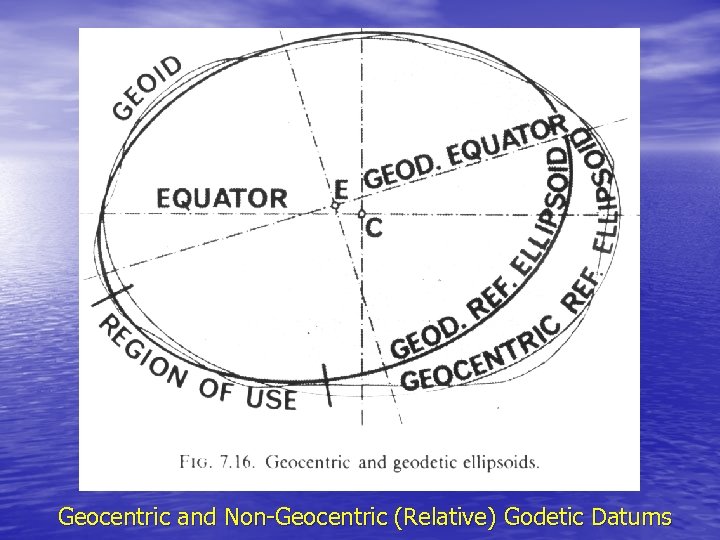
 2. 2 Geodetic Systems • In terms of Cartesian coordinates, the geodetic (G) coordinate system is that system which is introduced into the earth such that its three axes are coincident with or parallel to the corresponding three axes of the average terrestrial system (see Figure 2 -3). The first situation defines a geocentric geodetic system while the latter nongeocentric system is commonly referred to as a relative geodetic system, whose relationship to the average terrestrial system is given by the three datum translation components
 and in vector equation form, the relationship is where the position vector ri is referred to the geodetic system, that is and 2 -4

 • In this section we first describe the Cartesian (x, y, z) • • and curvilinear (latitude, longitude, height) coordinates for a point on the reference ellipsoid. We then develop expressions for its position vector in terms of various latitudes. Finally the transformation from geodetic coordinates ( , , h) to (x, y, z) and its inverse are discussed.
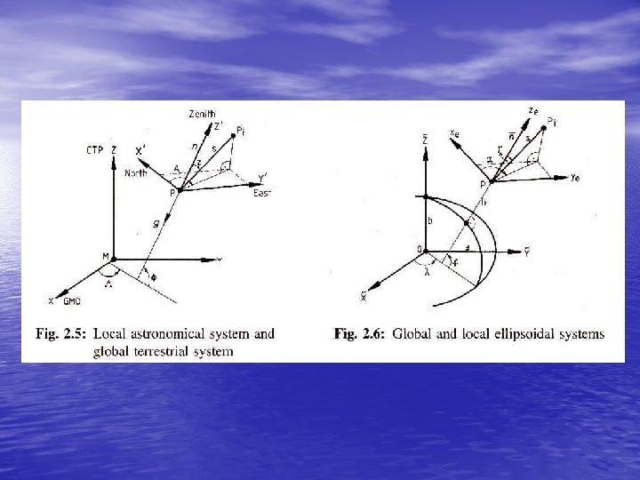
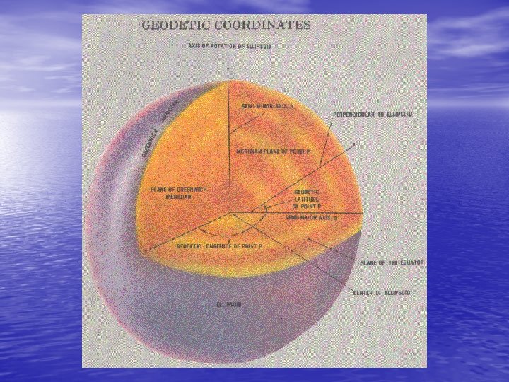
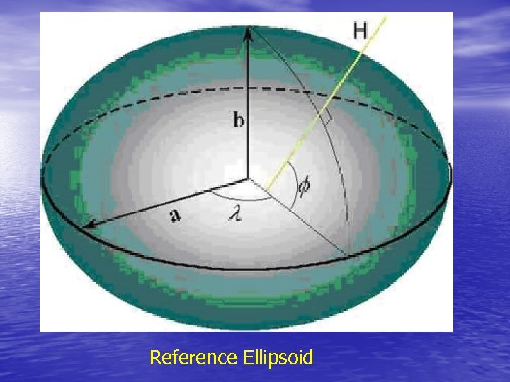
 • The specific ellipsoid used in geodesy as a reference surface is a rotational ellipsoid formed from the rotation of an ellipse about its semi-minor axis b (Figure 2 -5). The semi-major axis a and the flattening • 2 -5 are the defining parameters of the reference ellipsoid. Other useful parameters associated with this particular ellipsoid are the first eccentricity 2 -6 and the second eccentricity 2 -7

 • • A Cartesian coordinate system is superimposed on the reference ellipsoid (see Figure 2 -5) so that: a) The origin of the Cartesian system is the centre of the ellipsoid. b) The primary pole (z-axis) of the Cartesian system is the semi-minor axis of the ellipsoid. The primary plane is perpendicular to the primary axis and is called the equatorial plane. c) Any plane containing the semi-minor axis and cutting the surface of the ellipsoid is called a meridian plane. The particular meridian plane chosen as the secondary plane is called the Greenwich meridian plane. The secondary pole (x-axis) is the intersection of the equatorial plane and the Greenwich meridian plane. d) The y-axis is chosen to form a right-handed system, and lies in the equatorial plane, 90° counterclockwise from the x-axis.
 Figure 2. 5 b : The Ellipsoidal (Geodetic) Cartesian Coordinate System

 • The equation of this ellipsoid, in terms of Cartesian coordinates is • where 2 -8 2 -9 or 2 -10
 • The latitude of a point is the acute angular distance between the equatorial plane and the ellipsoid normal through the point measured in the meridian plane of the point. The line perpendicular to the ellipsoid at a point is called the ellipsoid normal at the point. Ellipsoid normals only pass through the geometric center of the ellipsoid in the equatorial plane or along the semi-minor axis. Therefore there are two different kinds of latitude. The angle between the ellipsoid normal at the point and the equatorial plane is called the geodetic latitude . The angle between the line joining the point to the centre of the ellipse, and the equatorial plane is called the geocentric latitude . There is also a third latitude, used mostly as a mathematical convenience, called the reduced latitude (see Figure 2 -6).
 • The longitude of a meridian plane is the counterclockwise angular distance between the Greenwich meridian plane and the meridian plane of the point, measured in the equatorial plane (see Figure 2 -5). • The ellipsoid height h of a point is its linear distance above the ellipsoid, measured along the ellipsoidal normal at the point (see Figure 2 -8).
 Figure 2. 6 : Geodetic, Geocentric and Reduced Latitude
 2. 2. 1 The Position Vector in Terms of the Geodetic Latitude • Consider a point P on the surface of the ellipsoid 2 -22 • N is the radius of curvature of the ellipsoid surface in the plane perpendicular to the meridian plane (called the prime vertical plane).
 We now refer the position vector P to a system with the primary axis in the Greenwich meridian plane, 2 -24
 2. 2. 2 The Position Vector in Terms of the Geocentric and Reduced Latitudes • From Figure 2 -6 the position vector of the point P in terms of the geocentric latitude is 2 -25 where is the magnitude of .
 • From Figure 2 -6 the reduced latitude of the point P is • the geocentric latitude of both the points Q and R, where Q is the projection of P parallel to the semi-minor axis to intersect a circle with radius equal to the semi-major axis, and R is the projection of the point P parallel to the semimajor axis to intersect a circle with radius equal to the semi-minor axis. The position vector of P in terms of the reduced latitude is 2 -26
 2. 2. 3 Relationships between Geodetic, Geocentric and Reduced Latitudes From equations 2 -24, 2 -25, and 2 -26 Canceling the cos term, 2 -27 2 -28 2 -29
 2. 2. 4 The Position Vector of a Point Above the Reference Ellipsoid Let us consider a terrain point i, as depicted in Figure 2 -8, whose coordinates are the geodetic latitude and longitude , and the ellipsoid height h. The projection of i onto the surface of the ellipsoid is along the ellipsoidal normal defined by the unit vector • The position vector of i is then the sum of two vectors, namely 2 -30 where is defined by equation 2 -24 and vector defined by equation 2 -68 c , that is is the unit

 • Thus or 2 -31 • Now the position vector in equation 2 -31 refers to a coordinate system whose origin is at the geometrical centre of the ellipsoid.

 • If this ellipsoid defines a relative geodetic system, then its centre will not in general coincide with the centre of gravity of the earth. The expression for the position vector in the average terrestrial system is, from equation 2 -4 • or 2 -32 This expression gives the general transformation from relative geodetic coordinates ( , , h) to average terrestrial coordinates (x, y, z), given the size of the ellipsoid (a, b) and the translation components (x , y , z ).
 2. 2. 5 Transformation from Average Terrestrial Cartesian to Geodetic Coordinates • A very useful transformation is the inverse of equation 2 -32. • Given the average terrestrial coordinates (x, y, z), the translation components (x 0, y 0, z 0), and the size of the ellipsoid (a, b), compute the relative geodetic coordinates ( , , h). First we translate the origin from the centre of gravity to the centre of the ellipsoid. From equation 2 -32 2 -33
 • The longitude is computed directly from 2 -34 The latitude and ellipsoid height h are more difficult to compute since N is a function of , from equation 2 -22
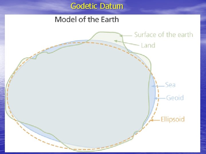
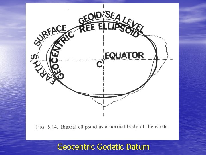
 2. 3 GEODETIC DATUMS • There are two natural figures of the earth (see Figure 2 -9); • the topographic or physical surface of the earth including the surface of the oceans (the terrain), and the equipotential surface of the earth's gravity field which coincides with an idealized surface of the oceans (the geoid). Control measurenents (e. g. distances, angles, spirit levelling) are made between points on the terrain which we call control points. These measurements are used to determine the geometrical relationship between the control points in a computation called network adjustment. Other points are then related to the network of control points through further measurements and computations called densification. The classical approach is to treat the vertical measurements, networks and computations separately from the horizontal measurements, networks and computations. However the unified three dimensional approach is currently gaining favour.
 • Even simpler surfaces than the ellipsoid (such as the • • sphere or the plane) can be sufficient approximations to the geoid if the area under consideration is sufficiently small, and/or the control application permits lower orders of accuracy. The introduction of a new surface (the ellipsoid) has a price. The horizontal control network (that is the coordinates of the points of the network) is to be referred to the ellipsoid. Therefore before network computations can begin, the control measurements must first be reduced so that they too "refer" to the ellipsoid. It is important to distinguish between the datum (the coordinate surface or ellipsoid surface) and the coordinates of the points of the network referred to the datum. It is a common but confusing practice (particularly in North America) to use the term "datum" for the set of coordinates
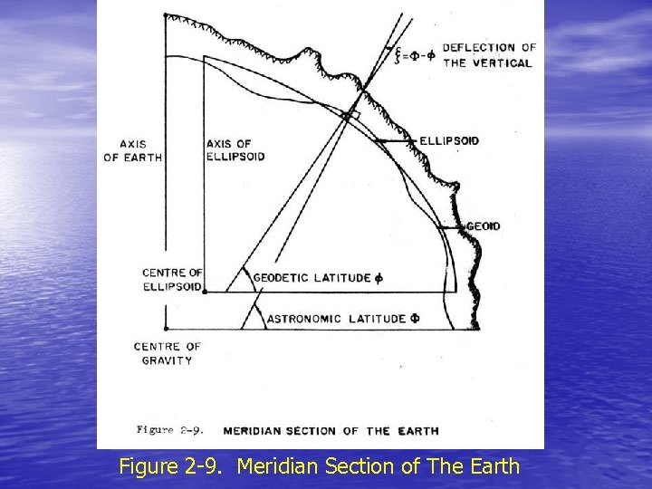 Figure 2 -9. Meridian Section of The Earth
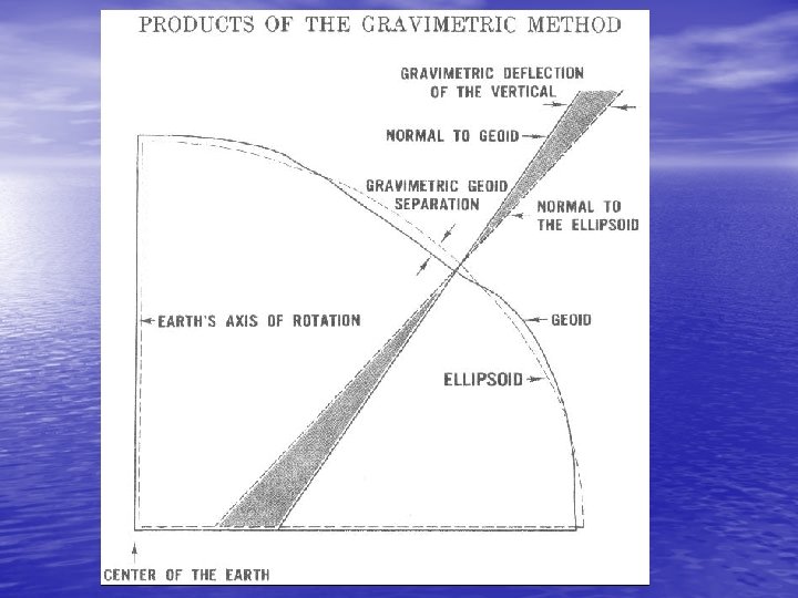
 • In the classical approach vertical measurements and networks • are referred to a coordinate surface or (vertical) datum which is the geoid. Rather than using the geoid as the coordinate surface or datum for the horizontal measurements and networks as well, a third, unnatural figure of the earth is introduced the ellipsoid of rotation discussed earlier. The reason a mathematical figure like the ellipsoid is used as the horizontal datum is to simplify the computations required both for network adjustment and densification. Correction terms are necessary in these computation to account for the fact that the datum is not the geoid. An ellipsoid can be chosen to approximate the geoid closely enough that these correction terms can be assumed linear and for some applications even ignored. For a well-chosen ellipsoid (see Figure 2 -9), the geoid-ellipsoid separation (geoid height) is always less than 100 metres, and the difference between the geoid and ellipsoid normals at any point (deflection of the vertical) is usually less than 5 arcseconds, very rarely exceeding 1 arcminute.
 • Even simpler surfaces than the ellipsoid (such as the sphere • • or the plane) can be sufficient approximations to the geoid if the area under consideration is sufficiently small, and/or the control application permits lower orders of accuracy. The introduction of a new surface (the ellipsoid) has a price. The horizontal control network (that is the coordinatas of the points of the network) is to be referred to the ellipsoid. Therefore before network computations can begin, the control measurements must first be reduced so that they too "refer" to the ellipsoid. It is important to distinguish between the datum (the coordinate surface or ellipsoid surface) and the coordinates of the points of the network referred to the datum. It is a common but confusing practice (particularly in North America) to use the term "datum" for the set of coordinates
 2. 3. 1 Datum Position Parameters • In order to establish an ellipsoid as the reference surface • for a system of control we must specify its size and shape (usually by assigning values to the semi-major axis and flattening) and we must specify its position with respect to the earth. A well-positioned ellipsoid will closely approximate the geoid over the area covered by the network for which it is in datum. The parameters to which we assign values in order to specify the ellipsoid position we call the datum position parameters. In three-dimensional space, any figure (and particularly our ellipsoid) has six degrees of freedom, that is six ways in which its position with respect to a fixed figure (in our case the earth) can be changed. Thus there are six datum position parameters.
 • Another way of looking at this is to consider two three- • dimensional Cartesian coordinate systems, one fixed to the ellipsoid and one fixed to the earth. In general the origins of the two systems will not coincide, and the axes will not be parallel. Therefore, to define the transformation from one system to the other we must specify the location of one origin with respect to the other system, and the orientation of one set of axes with respect to the other system, that is three coordinates, and three rotation angles. These six parameters provide a description of the six degrees of freedom and assigning values to them positions the ellipsoid with respect to the earth. They· are our six datum position parameters. A datum then is completely specified by assigning values to eight parameters - the ellipsoid size and shape, and the six datum position parameters. There are in fact two kinds of datum position parameters in use. One kind is obtained by considering the ellipsoid-fixed and earth- fixed coordinate systems to have their origins in the neighbourhood of the geocentre. The other kind is obtained by considering the ellipsoid-fixed and earth-fixed coordinate systems to have their origins near the surface of the earth at a point we call the initial point of the datum.
 • In the first (geocentric) case the earth-fixed system is the Average Terrestrial system of section 2. 1. 2, and the ellipsoid-fixed system is the geodetic system of Equation 2 -31 (except that here we assume the geodetic and average terrestrial axes are not in general parallel). In this case the datum position pararmeters are the Average Terrestrial coordinates of the ellipsoid origin (x 0, y 0, z 0 of Equation 2 -32) and three rotation angles (say 1, 2, 3) required to define the misalignment between the axes. It is of course highly desirable that the ellipsoid be positioned so that these angles are as small as possible, particularly that the two axes of symmetry (the ellipsoid minor axis and earth's average rotation axis or Average Terrestrial z-axis) be parallel. • In the second (topocentric) case the earth-fixed system is a local astronomic system at the initial point, and the ellipsoid-fixed system is a local geodetic system at the same point (local astronomic and geodetic systems are discussed in section 2. 4).
 • Before proceeding further let us consider the geometry in the neighbourhood of a point on the earth's surface. Figure 2 -10 is an exaggerated view of the geodetic meridian plane at such a point, showing the sectioned ellipsoid, geoid, several equipotential surfaces related to the geoid, and the terrain. A particular ellipsoid normal intersects the ellipsoid, geoid, and terrain at Q, P and T respectively. There are three "natural" normals corresponding to this ellipsoid normal; the surface gravity vertical (perpendicular to the equipotential surface at T, passing through T), the geoid gravity vertical (perpendicular to the geoid passing through P), and the plumbline (perpendicular to all equipotential surfaces between terrain and geoid, passing through T). In general, the plumbline is curved while the others are straight lines, and none of these three actually lie in the geodetic meridian plane - they are shown here as projections onto this plane. If the curvature of the plumbline is ignored the two gravity verticals are parallel.
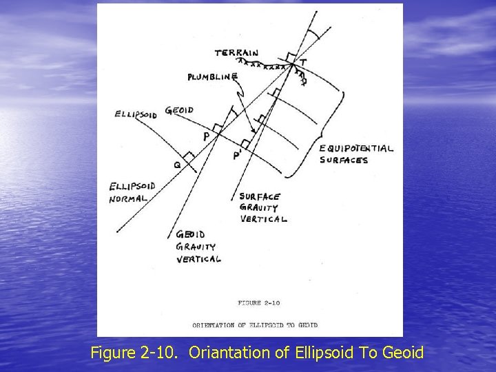 Figure 2 -10. Oriantation of Ellipsoid To Geoid
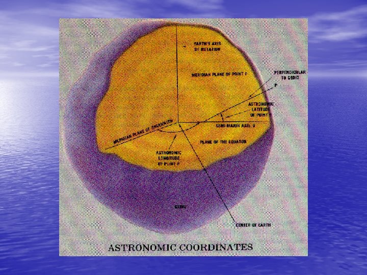
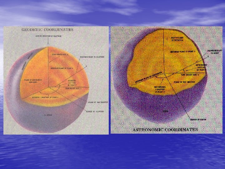
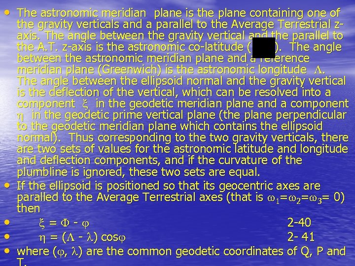 • The astronomic meridian plane is the plane containing one of • • the gravity verticals and a parallel to the Average Terrestrial zaxis. The angle between the gravity vertical and the parallel to the A. T. z-axis is the astronomic co-latitude ( ). The angle between the astronomic meridian plane and a reference meridian plane (Greenwich) is the astronomic longitude . The angle between the ellipsoid normal and the gravity vertical is the deflection of the vertical, which can be resolved into a component in the geodetic meridian plane and a component in the geodetic prime vertical plane (the plane perpendicular to the geodetic meridian plane which contains the ellipsoid normal). Thus corresponding to the two gravity verticals, there are two sets of values for the astronomic latitude and longitude and deflection components, and if the curvature of the plumbline is ignored, these two sets are equal. If the ellipsoid is positioned so that its geocentric axes are paralled to the Average Terrestrial axes (that is 1= 2= 3= 0) then = - 2 -40 = ( - ) cos 2 - 41 where ( , ) are the common geodetic coordinates of Q, P and
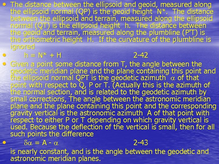 • The distance between the ellipsoid and geoid, measured along • • • the ellipsoid normal (QP) is the geoid height N*. The distance between the ellipsoid and terrain, measured along the ellipsoid normal (QT) is the ellipsoid height h. The distance between the geoid and terrain, measured along the plumbline (P'T) is the orthometric height H. If the curvature of the plumbline is ignored h = N* + H 2 -42 Given a point some distance from T, the angle between the geodetic meridian plane and the plane containing this point and the ellipsoid normal QPT is the geodetic azimuth of that point with respect to Q, P or T. (Actually this is the azimuth of the normal section, and is related to the geodetic azimuth by small corrections, The angle between the astronomic meridian plane and the plane containing this point and the corresponding gravity vertical is the astronomic azimuth A of that point with respect to either P or T depending on which gravity vertical is used. Because the deflection of the vertical is small, then for all such points the difference = A - 2 -43 is nearly constant, and is the angle between the geodetic and astronomic meridian planes.
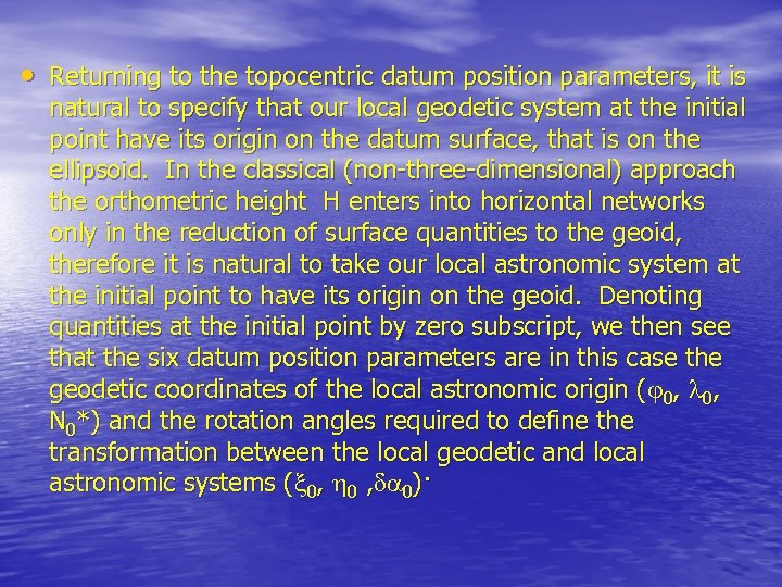 • Returning to the topocentric datum position parameters, it is natural to specify that our local geodetic system at the initial point have its origin on the datum surface, that is on the ellipsoid. In the classical (non-three-dimensional) approach the orthometric height H enters into horizontal networks only in the reduction of surface quantities to the geoid, therefore it is natural to take our local astronomic system at the initial point to have its origin on the geoid. Denoting quantities at the initial point by zero subscript, we then see that the six datum position parameters are in this case the geodetic coordinates of the local astronomic origin ( 0, N 0*) and the rotation angles required to define the transformation between the local geodetic and local astronomic systems ( 0, 0)·
 • 2. 3. 2 Establistment of a Datum • We have seen that a datum is defined by assigning values either to the eight parameters (a, b, x 0, y 0, z 0, w 1, w 2, w 3) or to the eight parameters (a, b, 0, N*0, 0, 0). However, an arbitrary set of values will not in general result in a satisfactory datum. We recall that it is important that a datum closely app roximate the geoid over the area of the network for which it is a datum, and that the geocentric axes of the geodetic coordinate system be closely parallel to the Average Terrestrial Axes, particularly that the axes of symmetry be parallel. The process of assigning values to the eight datum parameters in such a way that these characteristics are obtained is called establishment of a datum.
 • To begin with, in establishing a datum values are always • assigned to the topocentric set (a, b, 0, N*0, 0, 0) rather than the geocentric set (a, b, x 0, y 0, z 0, w 1, w 2, w 3) because it is the set which is related to the geodetic and astronomic measurements which we must use in establishing the datum. We see that we must somehow choose values for (a, b, 0, N*0, 0, 0) so that the values of (N*, , ) elsewhere in the network are not excessive (the datum approximates the geoid), and so that w 1 = w 2 = w 3 = 0 (the axes are parallel). Additionally for networks of global extent we require that x 0 = y 0 = z 0 = 0, in vhich case the datum is termed a geocentric datum. Otherwise the datum is a local datum. The problem of approximating the geoid can be ignored, in which case the values N*0 = 0 = 0 are assigned, which forces the ellipsoid to intersect and be tangent to the geoid at the initial point.
 • The geoid can be approximated in two vays, by choosing • values of (a, b, N*0, 0) such that either values of ( , ) or values of N* throughout the network are minimized (Vanicek, 1972). Note that values of (N*, , ) are available throughout the netvork only if some adjusted network already exists, which points up the iterative nature of datum establishment - a "best fitting" datum can be established only as an improvement on an already existing datum. The classical method of "ensuring" that the axes of symmetry are parallel is to enforce the Laplace azimuth condition at the initial point, that is to assign a value to 0 according to 0 = A 0 - 0 = 0 tan 0 2 -44 where A 0 is an observed astronomic azimuth.
 • This condition forces the geodetic and astronomic meridians to be parallel at the initial point, and thus forces both axes of symmetry to lie in this common plane. However, the axes of symmetry can still be misaligned within the meridian plane. The solution to this dilemma has been to apply the Laplace condition at several geodetic meridians parallel to their corresponding astronomic meridians. In essence this constrains the adjusted network to compensate for misalignment of the datum, rather than ensuring that the datum minor axis is parallel to the earth's rotation axis. Note that enforcing the Laplace condition throughout the network presumes the existance of an adjusted network, which again points up the iterative nature of datum establishment.
 Godetic Datum
 Geocentric Godetic Datum
 Reference Ellipsoid
 Geocentric and Non-Geocentric (Relative) Godetic Datums
 Non-Geocentric (Relative) Geodetic Datum • In terms of Cartesian coordinates, the geodetic (G) coordinate system is that system which is introduced into the earth such that its three axes are coincident with or parallel to the corresponding three axes of the average terrestrial system (see Figure 2 -3). The first situation defines a geocentric geodetic system while the latter non -geocentric system is commonly referred to as a relative geodetic system, whose relationship to the average terrestrial system is given by the three datum translation components
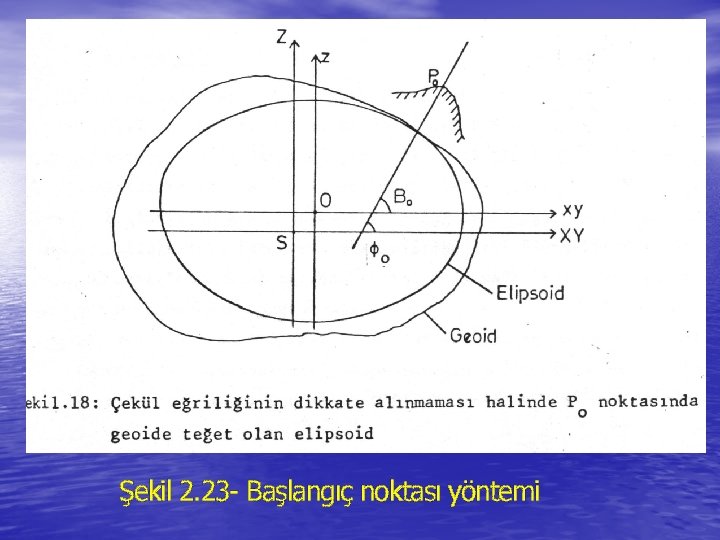 Şekil 2. 23 - Başlangıç noktası yöntemi
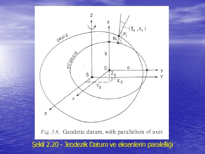 Şekil 2. 20 - Jeodezik Datum ve eksenlerin paralelliği
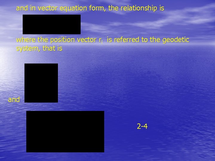 and in vector equation form, the relationship is where the position vector ri is referred to the geodetic system, that is and 2 -4
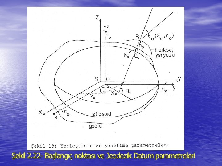 Şekil 2. 22 - Başlangıç noktası ve Jeodezik Datum parametreleri
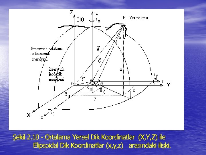 Şekil 2. 10 - Ortalama Yersel Dik Koordinatlar (X, Y, Z) ile Elipsoidal Dik Koordinatlar (x, y, z) arasındaki ilişki.
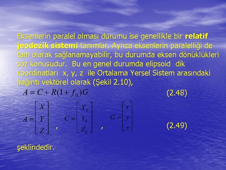 Eksenlerin paralel olması durumu ise genellikle bir relatif jeodezik sistemi tanımlar. Ayrıca eksenlerin paralelliği de tam olarak sağlanamayabilir, bu durumda eksen dönüklükleri söz konusudur. Bu en genel durumda elipsoid dik koordinatları x, y, z ile Ortalama Yersel Sistem arasındaki bağıntı vektörel olarak (Şekil 2. 10), (2. 48) , şeklindedir. , (2. 49)
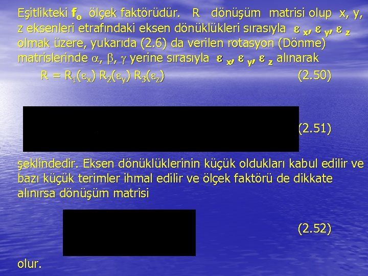 Eşitlikteki fo ölçek faktörüdür. R dönüşüm matrisi olup x, y, z eksenleri etrafındaki eksen dönüklükleri sırasıyla x, y, z olmak üzere, yukarıda (2. 6) da verilen rotasyon (Dönme) matrislerinde , , yerine sırasıyla x, y, z alınarak R = R 1 ( x ) R 2 ( y) R 3 ( z ) (2. 50) (2. 51) şeklindedir. Eksen dönüklüklerinin küçük oldukları kabul edilir ve bazı küçük terimler ihmal edilir ve ölçek faktörü de dikkate alınırsa dönüşüm matrisi (2. 52) olur.
 • Ortalama yersel sistemden jeodezik sisteme dönüşüm (2 -48) eşitliğinden eşitliği ile gerçekleştirilir.
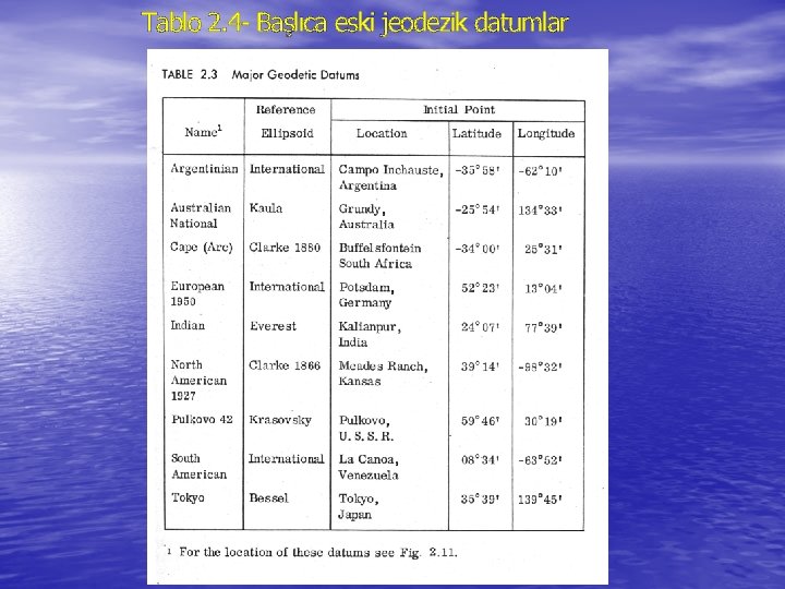 Tablo 2. 4 - Başlıca eski jeodezik datumlar
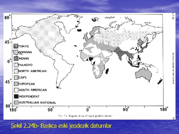 Şekil 2. 24 b- Başlıca eski jeodezik datumlar
 2. 3. 3 Deflection of The Vertical • The angle between the ellipsoid normal and the gravity vertical is the deflection of the vertical, which can be resolved into a component in the geodetic meridian plane and a component in the geodetic prime vertical plane (the plane perpendicular to the geodetic meridian plane which contains the ellipsoid normal).
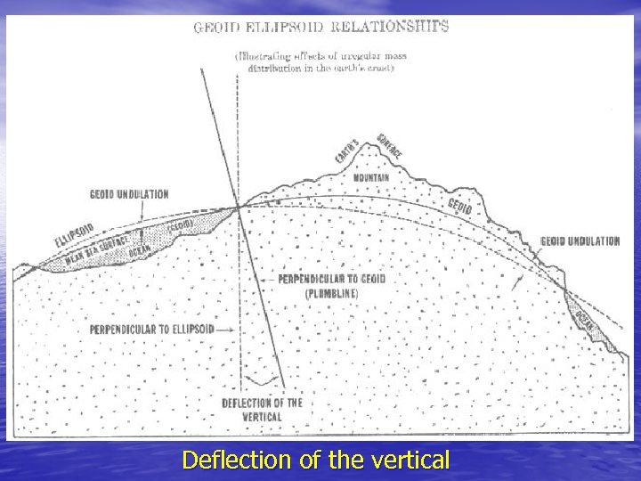 Deflection of the vertical
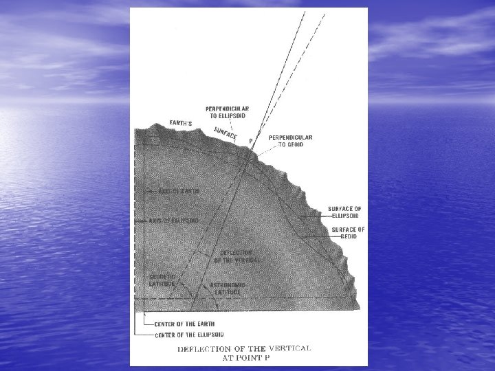
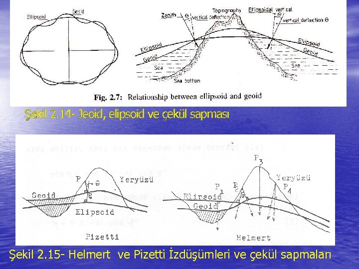 Şekil 2. 14 - Jeoid, elipsoid ve çekül sapması Şekil 2. 15 - Helmert ve Pizetti İzdüşümleri ve çekül sapmaları
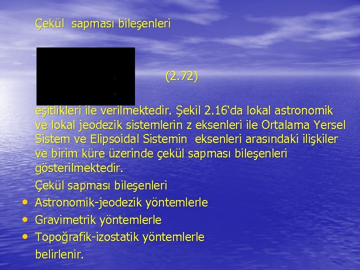 Çekül sapması bileşenleri (2. 72) • • • eşitlikleri ile verilmektedir. Şekil 2. 16‘da lokal astronomik ve lokal jeodezik sistemlerin z eksenleri ile Ortalama Yersel Sistem ve Elipsoidal Sistemin eksenleri arasındaki ilişkiler ve birim küre üzerinde çekül sapması bileşenleri gösterilmektedir. Çekül sapması bileşenleri Astronomik-jeodezik yöntemlerle Gravimetrik yöntemlerle Topoğrafik-izostatik yöntemlerle belirlenir.
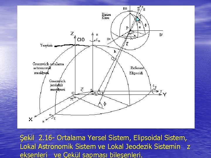 Şekil 2. 16 - Ortalama Yersel Sistem, Elipsoidal Sistem, Lokal Astronomik Sistem ve Lokal Jeodezik Sistemin z eksenleri ve Çekül sapması bileşenleri.
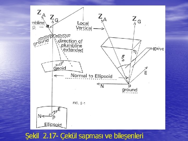 Şekil 2. 17 - Çekül sapması ve bileşenleri
 • Astronomik-jeodezik yöntemlerle belirlenen çekül sapmaları Astro-jeodezik çekül sapması olarak adlandırılır. Bir P noktasının astronomik enlem, boylam ve azimutu astronomik gözlemelerle belirlenir. Bu noktanın elipsoidal enlem ve boylamı yeryüzünde yapılan açı ve kenar ölçmeleri ile nirengi ağları kurularak hesaplanır. Astronomik yöntemlerle bulunan enlem, boylam ve azimut ile jeodezik ölçülerle elipsoid üzerinde yapılan hesaplarla bulunan elipsoidal enlem, boylam ve azimutun farkları ile elde edilen çekül sapması bileşenleri “Astro-jeodezik çekül sapması bileşenleri” olarak adlandırılır.
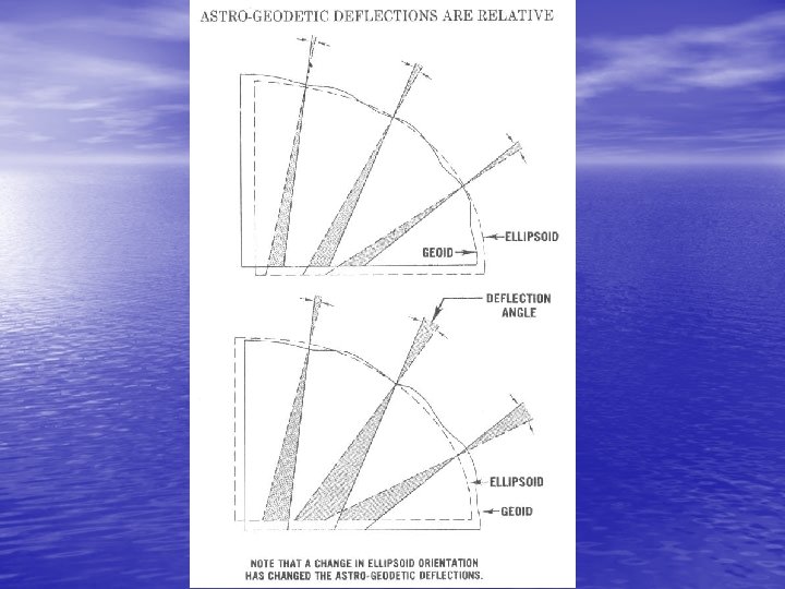
 • Hesapların yapıldığı referans elipsoidinin Ortalama Dünya Dik Koordinat Sistemine göre konumuna göre astrojeodezik çekül sapması bileşenleri rölatif çekül sapmaları veya mutlak çekül sapmaları olarak elde edilir. Eğer referans elipsoidinin merkezi yeryuvarının ağırlık merkezinde ve elipsoidal dik koordinat sisteminin x. y, z eksenleri Ortalama Dünya Dik Koordinat Sisteminin X, Y, Z eksenleri ile çakışık ise bu elipsoide göre hesaplanan çekül sapmaları “Mutlak Çekül Sapmaları” adını alır. Eğer referans elipsoidinin merkezi yeryuvarının ağırlık merkezinin dışında ise bu elipsoide göre hesaplanan çekül sapmaları “Rölatif Çekül Sapmaları” adını alır.
 2. 4 TERRESTRIAL TOPOCENTRIC SYSTEMS • • In the introduction it was stated that terrestrial topocentric systems are defined as follows: a) the origin is at a point near the surface of the earth, b) the primary plane is the plane tangential to the earth's surface at the point, c) the primary axis is the north point, d) the systems are left-handed.
 The last two specifications present no problems. However, "the surface of the earth" can be interpreted in three ways to mean the earth's physical surface, the earth's equipotential surface, or the surface of a reference ellipsoid. It is not practical to define a coordinate system in terms of a plane tangential to the earth's physical surface. 'Two kinds of terrestrial topocentric coordinate systems can be defined, however: The system in which the primary pole is the normal to the equipotential surface at the observation station is called a local astronomic system; The system in which the primary pole is the ellipsoid normal passing through the observation station is called a local geodetic system [Krakiwsky 1968].
 2. 4. 1 Local Astronomic System • • A local astronomic (L. A. ) system is specified: a) The origin is at the observation station. b) The primary pole (z-axis) is the normal to the equipotential surface (the gravity vertical) at the observation station. The primary plane is the plane containing the origin and perpendicular to the gravity vertical. c) The primary axis (x-axis) is the intersection of the primary plane and the plane containing the average terrestrial pole and the observation station, and is called the astronomic north. d) The y-axis is directed east to form a left-handed system.
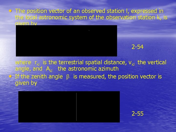 • The position vector of an observed station l, expressed in the local astronomic system of the observation station k, is given by 2 -54 • where rkl is the terrestrial spatial distance, vkl the vertical angle, and Akl the astronomic azimuth If the zenith angle is measured, the position vector is given by 2 -55
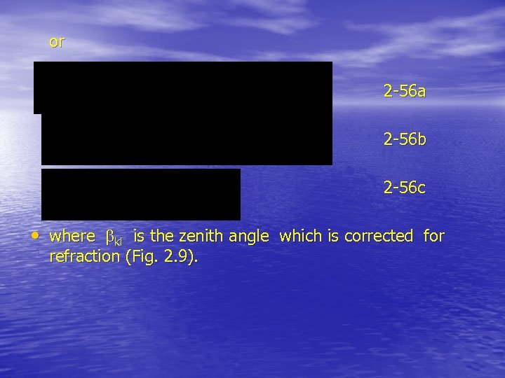 or 2 -56 a 2 -56 b 2 -56 c • where kl is the zenith angle which is corrected for refraction (Fig. 2. 9).
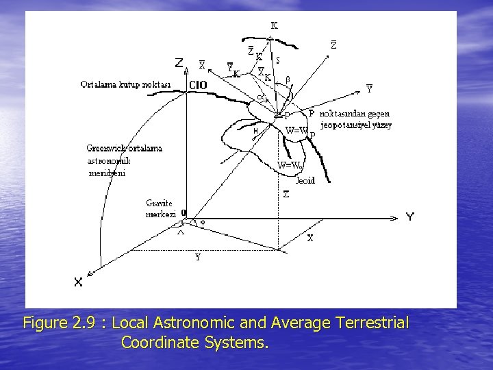 Figure 2. 9 : Local Astronomic and Average Terrestrial Coordinate Systems.
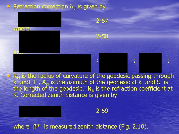 • Refraction correction kl is given by 2 -57 where 2 -58 and ; ; ; • Rkl is the radius of curvature of the geodesic passing through k and l , Akl is the azimuth of the geodesic at k and S is the length of the geodesic. kk is the refraction coefficient at K. Corrected zenith distance is given by 2 -59 where * is measured zenith distance (Fig. 2. 10).
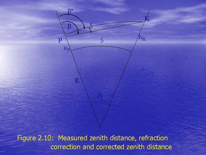 * P K S h. P h. K R 2 Figure 2. 10: Measured zenith distance, refraction correction and corrected zenith distance
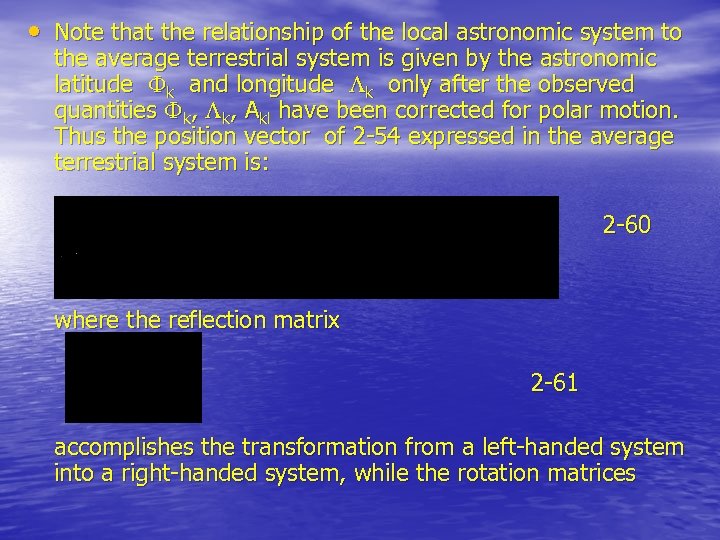 • Note that the relationship of the local astronomic system to the average terrestrial system is given by the astronomic latitude k and longitude k only after the observed quantities k, Akl have been corrected for polar motion. Thus the position vector of 2 -54 expressed in the average terrestrial system is: 2 -60 where the reflection matrix 2 -61 accomplishes the transformation from a left-handed system into a right-handed system, while the rotation matrices
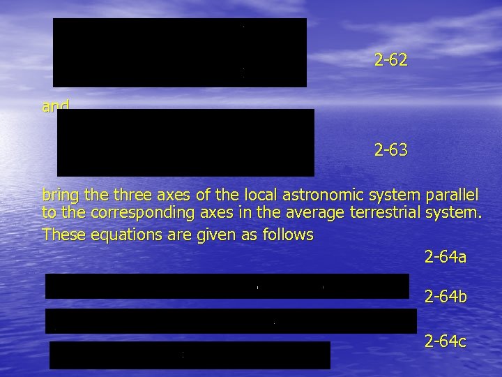 2 -62 and 2 -63 bring the three axes of the local astronomic system parallel to the corresponding axes in the average terrestrial system. These equations are given as follows 2 -64 a 2 -64 b 2 -64 c
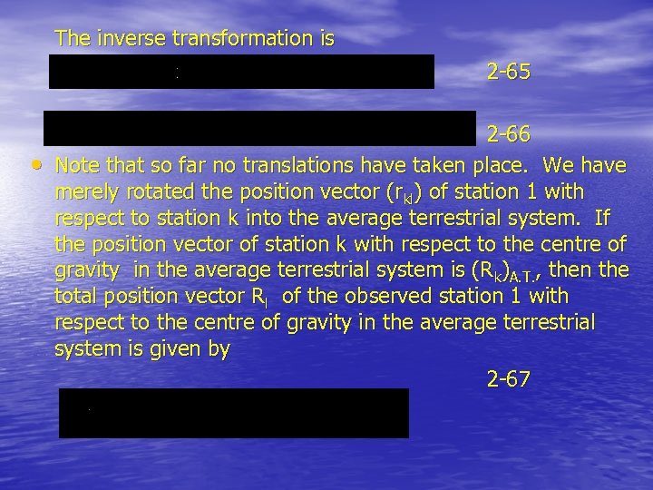 The inverse transformation is 2 -65 • 2 -66 Note that so far no translations have taken place. We have merely rotated the position vector (rkl) of station 1 with respect to station k into the average terrestrial system. If the position vector of station k with respect to the centre of gravity in the average terrestrial system is (Rk)A. T. , then the total position vector Rl of the observed station 1 with respect to the centre of gravity in the average terrestrial system is given by 2 -67
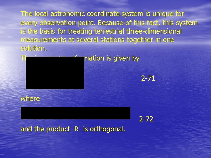 The local astronomic coordinate system is unique for every observation point. Because of this fact, this system is the basis for treating terrestrial three-dimensional measurements at several stations together in one solution. The inverse transformation is given by 2 -71 where 2 -72 and the product R is orthogonal.
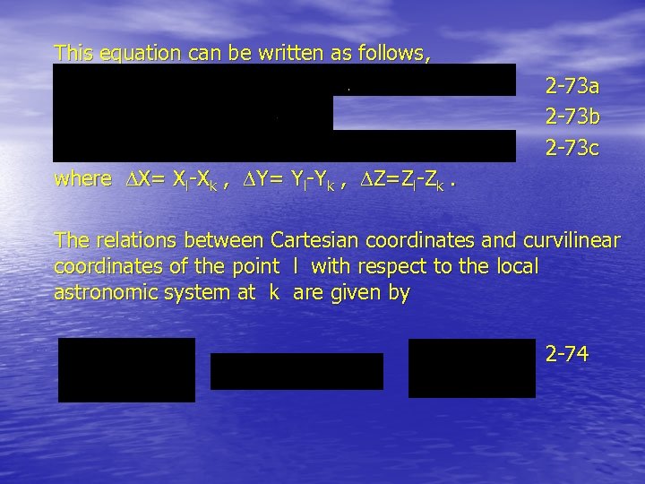 This equation can be written as follows, 2 -73 a 2 -73 b 2 -73 c where X= Xl-Xk , Y= Yl-Yk , Z=Zl-Zk. The relations between Cartesian coordinates and curvilinear coordinates of the point l with respect to the local astronomic system at k are given by 2 -74
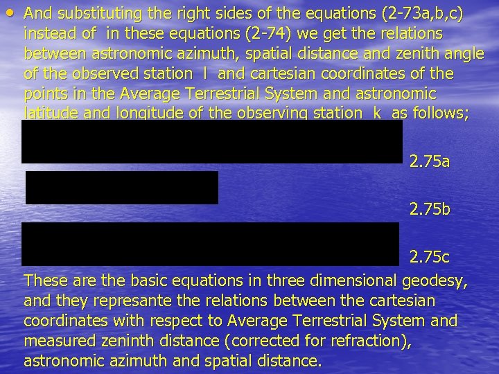 • And substituting the right sides of the equations (2 -73 a, b, c) instead of in these equations (2 -74) we get the relations between astronomic azimuth, spatial distance and zenith angle of the observed station l and cartesian coordinates of the points in the Average Terrestrial System and astronomic latitude and longitude of the observing station k as follows; 2. 75 a 2. 75 b 2. 75 c These are the basic equations in three dimensional geodesy, and they represante the relations between the cartesian coordinates with respect to Average Terrestrial System and measured zeninth distance (corrected for refraction), astronomic azimuth and spatial distance.
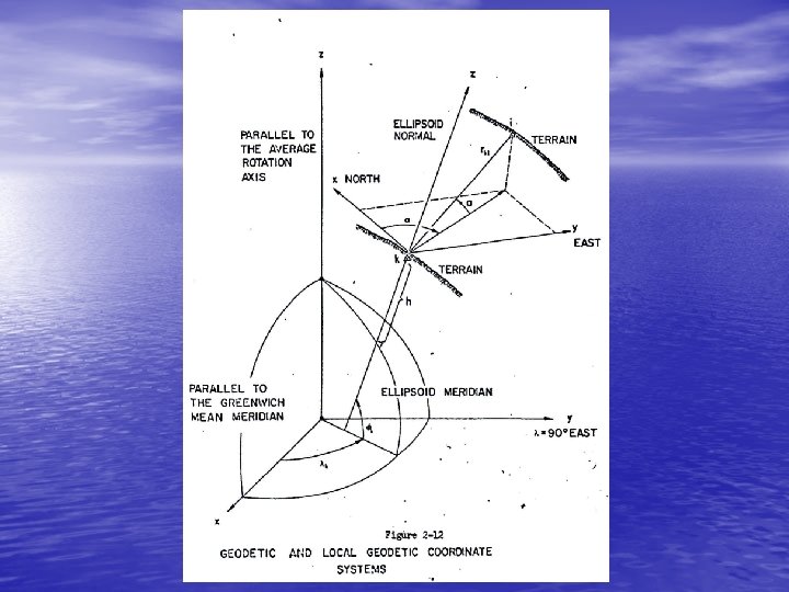
 2. 4. 2. Local Geodetic System • • A local geodetic (L. G. ) system is specified (see Figure 2 -11 and 2 -12): a) The origin lies along the ellipsoidal normal passing through the observation station. Note that in principle the origin may lie anywhere along the ellipsoidal normal. In practice it is chosen to be at the observation station, at the ellipsoid, or at the intersection of the ellipsoidal normal with the geoid. b) The primary pole (z-axis) is the ellipsoidal normal. The primary plane is the plane containing the origin and perpendicular to the primary pole. c) The primary axis (x-axis) is the intersection of the primary plane and the plane containing the semi-minor axis of the ellipsoid and the origin, and is called the geodetic north. d) The y-axis is directed east to form a left-handed system.
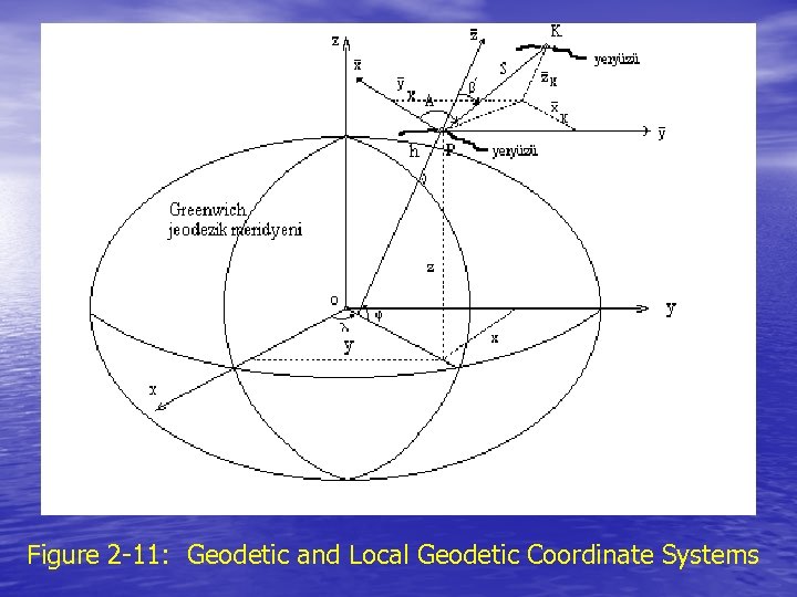 Figure 2 -11: Geodetic and Local Geodetic Coordinate Systems
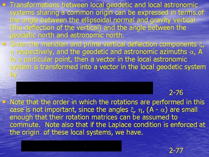 • Transformations between local geodetic and local astronomic • • systems sharing a common origin can be expressed in terms. of the angle between the ellipsoidal normal and gravity vertical (the deflection of the vertical) and the angle between the geodetic north and astronomic north. Given the meridian and prime vertical deflection components , respectively, and the geodetic and astronomic azimuths , A to a particular point, then a vector in the local astronomic system is transformed into a vector in the local geodetic system by 2 -76 Note that the order in which the rotations are performed in this case is not important, since the angles , , (A - ) are small enough that their rotation matrices can be assumed to commute. Note also that if the Laplace condition is enforced at the origin of these local systems, we have. 2 -77
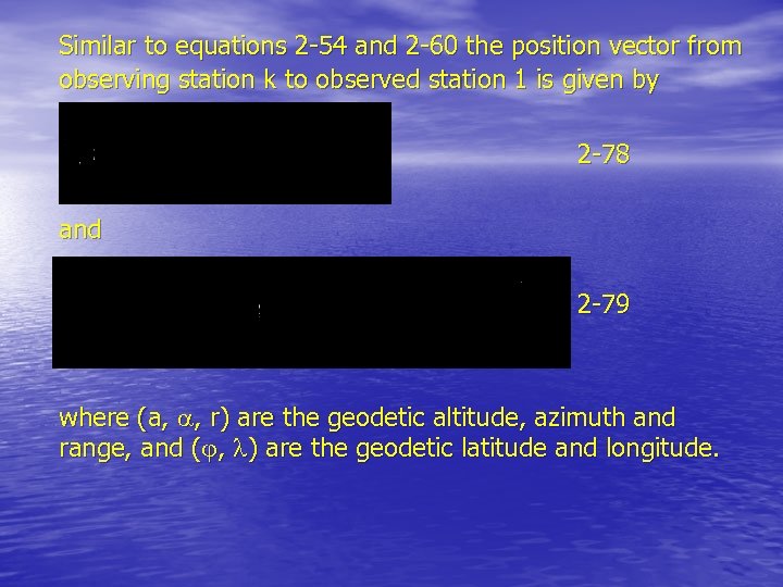 Similar to equations 2 -54 and 2 -60 the position vector from observing station k to observed station 1 is given by 2 -78 and 2 -79 where (a, , r) are the geodetic altitude, azimuth and range, and ( , ) are the geodetic latitude and longitude.
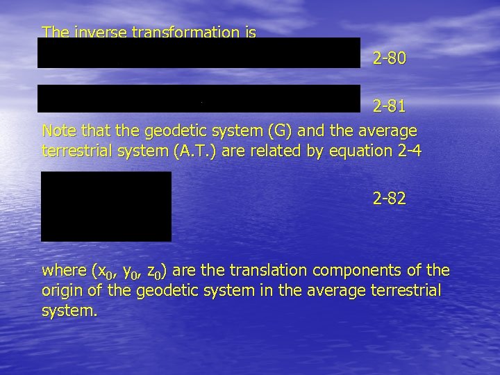 The inverse transformation is 2 -80 2 -81 Note that the geodetic system (G) and the average terrestrial system (A. T. ) are related by equation 2 -4 2 -82 where (x 0, y 0, z 0) are the translation components of the origin of the geodetic system in the average terrestrial system.
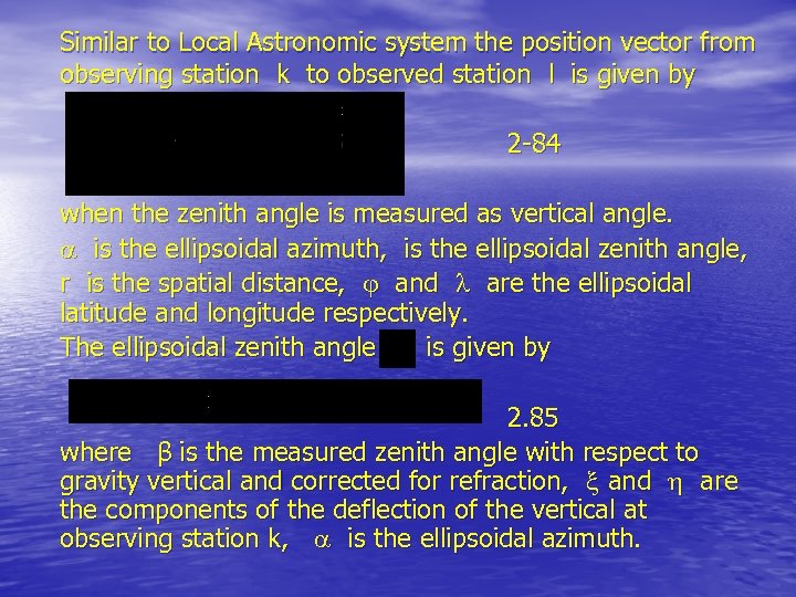 Similar to Local Astronomic system the position vector from observing station k to observed station l is given by 2 -84 when the zenith angle is measured as vertical angle. is the ellipsoidal azimuth, is the ellipsoidal zenith angle, r is the spatial distance, and are the ellipsoidal latitude and longitude respectively. The ellipsoidal zenith angle is given by 2. 85 where β is the measured zenith angle with respect to gravity vertical and corrected for refraction, and are the components of the deflection of the vertical at observing station k, is the ellipsoidal azimuth.
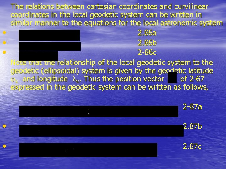 • • • The relations between cartesian coordinates and curvilinear coordinates in the local geodetic system can be written in similar manner to the equations for the local astronomic system 2. 86 a 2. 86 b 2 -86 c Note that the relationship of the local geodetic system to the geodetic (ellipsoidal) system is given by the geodetic latitude k and longitude k. Thus the position vector of 2 -67 expressed in the geodetic system can be written as follows, 2 -87 a • 2. 87 b • 2. 87 c
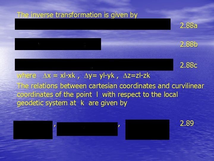 The inverse transformation is given by 2. 88 a 2. 88 b 2. 88 c where x = xl-xk , y= yl-yk , z=zl-zk The relations between cartesian coordinates and curvilinear coordinates of the point l with respect to the local geodetic system at k are given by , , 2. 89
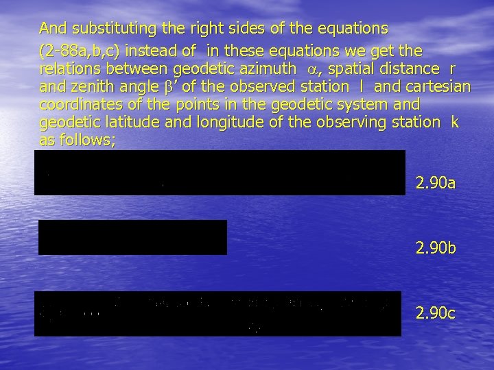 And substituting the right sides of the equations (2 -88 a, b, c) instead of in these equations we get the relations between geodetic azimuth , spatial distance r and zenith angle ’ of the observed station l and cartesian coordinates of the points in the geodetic system and geodetic latitude and longitude of the observing station k as follows; 2. 90 a 2. 90 b 2. 90 c
