1ae8936dd7455dbb0f66a20eaba7f8b0.ppt
- Количество слайдов: 15


COASTAL DATA INFORMATION PROGRAM • Based at SIO • 32 Wave Stations • 14 People • $2. 5 M+ / year budget • Funded by: CDBW USACE (SCCOOS BEACON ONR…) CDIP Mission • Develop US nearshore wave climatology for more rational design decisions

27 Operational CDIP Stations • • • 23 Directional Wave Buoys 2 Pressure sensor stations 2 Anemometers California, Georgia, Guam, Hawaii, Oregon, Washington ---------------------- 150 Historical Stations (1975 -present) • • 63 Wave Buoys 30 Directional Arrays 36 Surge – Inner Harbor 21 Single Point Pressure California, Georgia, Hawaii, Minnesota, North Carolina, Oregon, Virginia, Washington, Guam Approx 300 GB Data Storage

Data Transmission HF/FM Transmission 29 Km max distance from shore Datawell Directional Wave Buoy Net/Phone/ Wireless Modem Data transferred @ 30 minutes Data Acquisition System Located at Coast Guard, Harbor Master, Marine Exchange offices Scripps Central Computer Facility -

CDIP In-House Diagnostics 2002 - Data Collection Coverage Percentages Pt. Reyes – 91. 88% La Jolla – 99. 66% Torrey Pines I – 99. 09% Torrey Pines O – 99. 23% Oceanside – 99. 29% Harvest – 94. 70% San Pedro – 94. 95% Dana Point – 99. 47% San Pedro – 94. 95% Pt Dume – 95. 88% Harvest – 94. 70% Pt. Reyes – 91. 88% Grays Harbor – 87. 56%
")
MODELS NOWCASTS FORECASTS MEASUREMENTS (update @ 30 min)

Modeling Waves Across the Basin Headland shadowing Refractive effects Directional wave buoy to initiate model Island shadowing Diffraction effects Amplification over shoals

West Swell Northwest Swell

San Pedro Harbor West Swell South Swell

San Francisco Swell Model

FORECAST MODELS

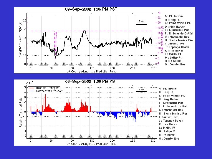
Nearshore Directional wave prediction along the 10 m depth contour Santa Monica Bay Directional Buoy •

END USERS - WAVES COMMERCIAL MARINERS MILITARY & GOV RECREATIONAL
 CDIP Wave Buoys LIDAR In-Situ ATV & Jet.")
SOUTHERN CALIFORNIA BEACH PROCESSES STUDY (SCBPS) CDIP Wave Buoys LIDAR In-Situ ATV & Jet. Ski Surveys: San Onofre and Torrey Pines

END USERS – SAND/EROSION Torrey Pines State Beach, 11/23/02 LOCAL GOVERNMENTS COASTAL ENGINEERS
1ae8936dd7455dbb0f66a20eaba7f8b0.ppt