

74d17fdcbac948e433357c895fe31d92.ppt
- Количество слайдов: 51
 Climate
 Methods of heat transfer-how heat is moved through the atmosphere • 1. Conduction- heat transferred through direct contact. (Ex: metal spoon in boiling pot) • 2. Radiation- heat transferred from sun to earth’s surface • 3. Convection- cycle of warm rising, cool sinking due to differences in density ( Ex: Magma inside the earth, warm & cold fronts)
 What type of heat transfer is this? How is the heat transferred?
 Angle of Insolation – angle at which the Sun heats the earth
 Definition • Climate is the average weather in a location over a long period of time. Ex: A place that doesn't get much rain over many years would have a dry climate. – A place where it stays cold for most of the year would have a cold climate.
 o 23.") World Climates- 3 main groups o 0 -23. 5 1 -Low-latitude (Tropical) o 23. 5 -66. 5 2 -Mid-latitude (Temperate) o 66. 5 -90 3 -High-latitude (Polar)
World Climates- 3 main groups o 0 -23. 5 1 -Low-latitude (Tropical) o 23. 5 -66. 5 2 -Mid-latitude (Temperate) o 66. 5 -90 3 -High-latitude (Polar)
 Classifying Climate • Temperature • Precipitation 6 major climate groups 1. Tropical rainy 2. Dry 3. Temperate marine 4. Temperate continental 5. Polar 6. Highlands
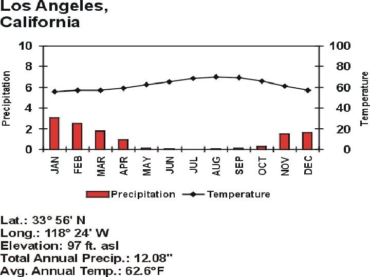
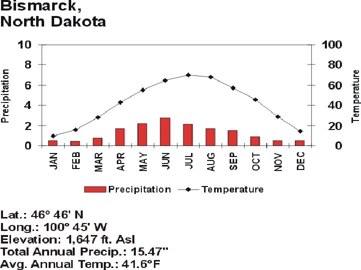
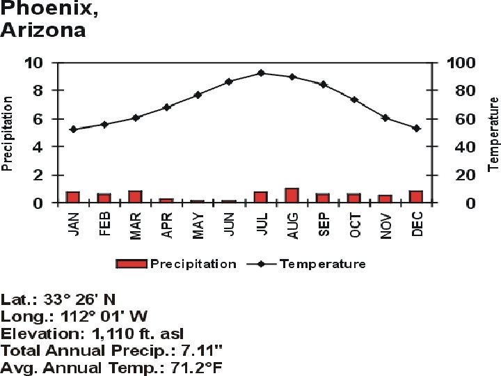
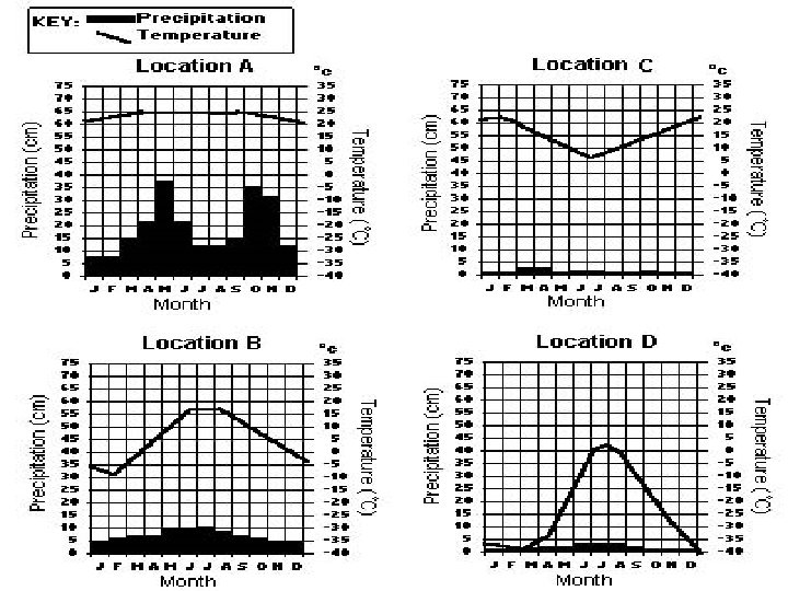
- shows precipitation and temperature of a location bars = precipitation lines") Climate graph (Climograph)- shows precipitation and temperature of a location bars = precipitation lines = temperature
Climate graph (Climograph)- shows precipitation and temperature of a location bars = precipitation lines = temperature
 Latitude-") Climate is classified by: Temperature and precipitation 5 factors that effect climate 1) Latitude- distance from equator 2) Altitude- (mountain) 3) Global Winds- trade winds, prevailing westerlies, polar easterlies 4) Ocean currents- warm/cool climates 5) Nearness to center of continent or large body of water 1) Sea breeze and land breeze 2) Windward v. Leeward side of mountain
Climate is classified by: Temperature and precipitation 5 factors that effect climate 1) Latitude- distance from equator 2) Altitude- (mountain) 3) Global Winds- trade winds, prevailing westerlies, polar easterlies 4) Ocean currents- warm/cool climates 5) Nearness to center of continent or large body of water 1) Sea breeze and land breeze 2) Windward v. Leeward side of mountain
 for a") Important facts on Climate: • The average weather conditions (temperature and moisture) for a large region over a long period of time. • Factors affecting climate include: • ‣Latitude- The higher your latitude, the colder your climate. • ‣Altitude- The higher your altitude, the colder your climate. • ‣Mountain ranges- On the windward side of a mountain, your climate will be wet, on the leeward side of a mountain, your climate will be dry. • ‣Oceans/Large Bodies of Water- The closer you are to water, the less extreme your climate (warmer winters and cooler summers). • ‣Ocean Currents- Locations near warm water currents will have warmer climates, locations near cold water currents will have colder climates. • ‣Planetary Wind Belts- On-shore winds will cause wet climates, offshore winds will cause dry climates (monsoon winds).
Important facts on Climate: • The average weather conditions (temperature and moisture) for a large region over a long period of time. • Factors affecting climate include: • ‣Latitude- The higher your latitude, the colder your climate. • ‣Altitude- The higher your altitude, the colder your climate. • ‣Mountain ranges- On the windward side of a mountain, your climate will be wet, on the leeward side of a mountain, your climate will be dry. • ‣Oceans/Large Bodies of Water- The closer you are to water, the less extreme your climate (warmer winters and cooler summers). • ‣Ocean Currents- Locations near warm water currents will have warmer climates, locations near cold water currents will have colder climates. • ‣Planetary Wind Belts- On-shore winds will cause wet climates, offshore winds will cause dry climates (monsoon winds).
 Wind • Wind is the horizontal movement of air from an area of high pressure to an area of low pressure. • Winds are caused by differences in air pressure. • These differences are caused by the uneven heating of the Earth’s surface. • Winds are named by their direction (where they originate from) and speed. • Wind speed is measured by an anemometer.
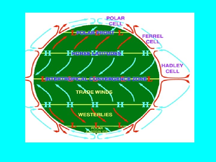
 Global Winds: winds that blow steadily over long distances-caused by the uneven heating of Earth’s surface over a large area. Global Convection Currents – The sun’s rays hit the equator directly causing extremely high temperatures, the poles are much cooler. This large difference in temperature causes air pressure near the equator to be low and greater near the poles. This difference in pressure causes giant convection currents called global winds. The Coriolis Effect - Since the Earth rotates from west to east the winds do not move in a straight line but are actually curved. • Global winds from the north curve toward the right (west) and global winds from the south curve toward the left (east)
 Global Winds
 Coriolis Effect • The Coriolis force- affects the direction of wind flow due to earth’s rotation. • This force is what causes objects in the northern hemisphere to turn to the right and objects in the southern hemisphere to turn to the left.
 Doldrums: Along the equator the air is a constant warm temperature which is constantly rising. There is little or no lateral movement (no wind) Horse Latitudes: At about 30°latitude, the air stops moving toward the poles and sinks. So, once again there is little or no lateral movement (no wind) Trade Winds: Blow between the equator and 30°latitudes, both north and south. They blow from the northeast and the southeast toward the west. These constant steady winds are what early sailors depended on. Prevailing Westerlies: Between 30° to 60° latitudes north and south. They blow from the northwest and the southwest toward the poles in an easterly curve. Polar Easterlies: Blow cold air away from the poles – They meet the prevailing westerlies at 60° latitudes and produce the polar front. This mixing of cold and hot air has a major effect on weather in the U. S. Jet Streams: Upper troposphere to lower stratosphere (about 10 km up) Bands of high speed winds. Blow from west to east in a wavy pattern
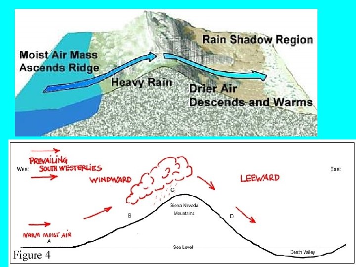
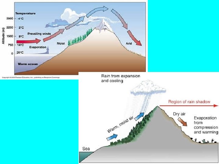
 When air is forced to rise because it hits mountains, it will expand, cool, and condense - Windward side = a cool, moist climate. - Leeward side= a warm and dry climate
 Specific heat • The ability to resist being heated – Low specific heat = heat up and cool down fast – High specific heat = heat up and cool down slowly
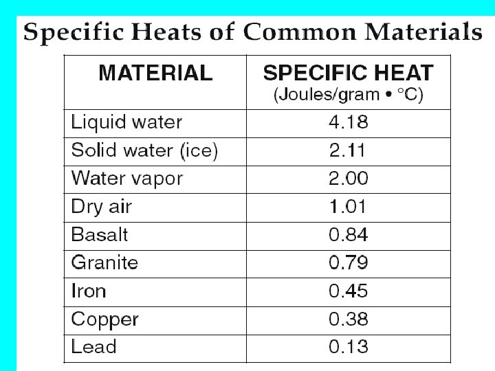
 Sea Breeze- Day • Water has a high Air sinks over water and moves to land specific heat= takes longer to warm up and cool down • Air over water is cooler, so it sinks and a breeze moves from water to land
 Land Breeze- Night • At night , the land will cool down faster than the water- the breeze then moves from land to sea
 TAKE A LOOK AT ANOTHER TWO LOCATIONS AT NEARLY THE SAME LATITUDE Nations Online Project: http: //www. nationsonline. org/oneworld/usa_map. htm
 Average Jan and July Temperatures Seattle: High 47 F , Low 37 F July: High 75 F, Low 55 warmer winter, cooler summer= coastal locations Bismarck: High 23 F , Low 2 F July: High 84 F, Low 56 F Cooler winter, Warmer summer= inland locations From Weather channel: www. weather. com
 Oceanic currents are driven by global winds and differences in water density (warm water – less dense, cold water – more dense)
 Some of the currents are moving warm water – and some are moving cool water From http: //tornado. sfsu. edu/geosciences/classes/m 356/Ocean. Currents/Global_currents. jpg
 LETS COMPARE TWO PLACES NEAR THE OCEAN Halifax, Nova Scotia • Latitude 44. 67 o N • Average Jan temp High 29 o. F Low 13 o. F London, England • Latitude 51. 5072° N • Average Jan Temp High 5 oo. F Low 41 o. F
 http: //www. holiday-weather. com
 Key points on factors of climate • Water modifies temperature- Coastal locations will have warmer winters and cooler summers • Greater temperature range inland • Water heats up and cools off much slower than land-high specific heat • Latitude determines wet and dry zones • Warm ocean currents start near the equator and travel away from equator
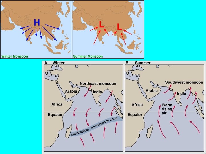
 Monsoons • A monsoon is a seasonal change in the direction of the prevailing, or strongest, winds of a region. • Monsoons cause wet and dry seasons • Monsoons are most often associated with the Indian Ocean. • Monsoons always blow from cold to warm regions.
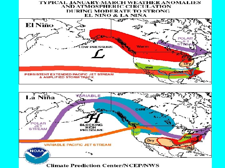
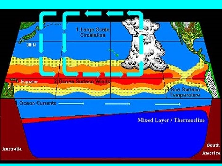
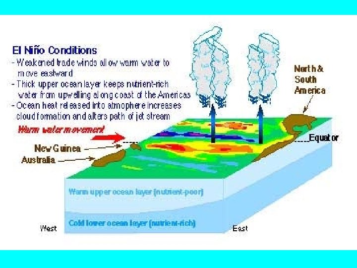
 • http: //www. bom. gov. au/lam/Students_Teachers/elnanim/elani. shtml El Nino and La Nina • Climate pattern that happens every 5 -7 years • El Nino- Characterized by unusually warm sea surface temperatures in the Pacific Ocean • La Nina- characterized by unusually cold sea surface temperatures • The hot water usually comes first to the coasts of Peru and Ecuador in South America. In the 1500 s, fishermen who lived in South America began to wonder about a current of unusually warm water that came to their shore every few years near Christmastime. Since the fishermen believed in the birth of the Christ child at Christmas, and since they spoke Spanish, they named the hot water El Niño, which means "the infant" in Spanish http: //www. fi. edu/weather/nino. html
 Electromagnetic Energy • Insolation – incoming solar radiation – Direct- straight to earth’s surface – Diffuse- scattered or reflected by atmospheric elements (clouds) Infrared radiation • Electromagenetic radiation of a longer wavelength (red= heat)
 and leaves as long-wave") Energy from the sun enters as shortwave radiation (visible, UV) and leaves as long-wave radiation (infrared)
Energy from the sun enters as shortwave radiation (visible, UV) and leaves as long-wave radiation (infrared)
 Greenhouse effect • The natural heating of Earth’s surface by certain atmospheric gases • We could not live without the greenhouse effect • Greenhouse gases include: CO 2, water vapor, methane, and nitrous oxide • Any increase in these gases would cause an increase in absorbed radiation • This can lead to global warming! • Burning of fossil fuels, deforestation(cutting down trees), pollution causes global warming
 Greenhouse effect
 How is Carbon dioxide put into the atmosphere? When Do You Send Greenhouse Gases into the Air? Whenever you. . . Play a Video Game • Listen to a Stereo • Wash or Dry Clothes • Watch TV • Use a Dish • Use the Air Conditioner Washer • Turn on a Light • Microwave a • Use a Hair Dryer Meal • Ride in a Car
 How can we help? • The following is a list of 10 steps YOU can take to reduce greenhouse gas emissions: • Reduce, Reuse, Recycle. . • Use Less Heat and Air Conditioning. . • Replace Your Light Bulbs. . • Drive Less and Drive Smart. . • Buy Energy-Efficient Products. . • Use Less Hot Water. . • Use the "Off" Switch. . • Plant a Tree.
 and nitrogen oxides") Acid Rain • Acid rain results when sulfur dioxide (SO 2) and nitrogen oxides (NOX) are emitted into the atmosphere and transported by wind air currents. • The SO 2 and NOX react with water, oxygen and other chemicals to form sulfuric and nitric acids. These then mix with water and other materials before falling to the ground. • While a small portion of the SO 2 and NOX that cause acid rain is from natural sources such as volcanoes • Most of it comes from the burning of fossil fuels. The major sources of SO 2 and NOX in the atmosphere are: – Burning of fossil fuels to generate electricity. Two thirds of SO 2 and one fourth of NOX in the atmosphere come from electric power generators. – Vehicles and heavy equipment. – Manufacturing, oil refineries and other industries
Acid Rain • Acid rain results when sulfur dioxide (SO 2) and nitrogen oxides (NOX) are emitted into the atmosphere and transported by wind air currents. • The SO 2 and NOX react with water, oxygen and other chemicals to form sulfuric and nitric acids. These then mix with water and other materials before falling to the ground. • While a small portion of the SO 2 and NOX that cause acid rain is from natural sources such as volcanoes • Most of it comes from the burning of fossil fuels. The major sources of SO 2 and NOX in the atmosphere are: – Burning of fossil fuels to generate electricity. Two thirds of SO 2 and one fourth of NOX in the atmosphere come from electric power generators. – Vehicles and heavy equipment. – Manufacturing, oil refineries and other industries
 The Positive NAO index phase shows a stronger than usual subtropical high pressure center and a deeper than normal Icelandic low. The increased pressure difference results in more and stronger winter storms crossing the Atlantic Ocean on a more northerly track. This results in warm and wet winters in Europe and in cold and dry winters in northern Canada and Greenland The eastern US experiences mild and wet winter conditions
 Negative NAO Index The negative NAO index phase shows a weak subtropical high and a weak Icelandic low. The reduced pressure gradient results in fewer and weaker winter storms crossing on a more west-east pathway. They bring moist air into the Mediterranean and cold air to northern Europe The US east coast experiences more cold air outbreaks and hence snowy weather conditions. Greenland, however, will have milder winter temperatures
 North Atlantic Oscillation