

0eb939d1bb70c17204dc2269ec4168f0.ppt
- Количество слайдов: 94
 Cities of South America
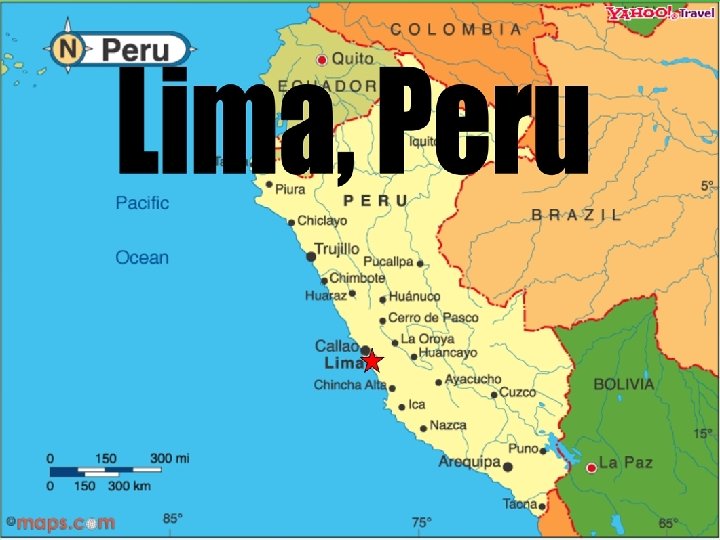
 • Population in metropolitan area: 6. 4 million (accounts for 1/3 of the nation’s population and workforce) • Total population (2003): 7. 9 million growing over 4% annually • 90% Mestizo (mixed European and Native American) with small minorities of whites, blacks, and Asians • Capital and largest city of Peru (actually 10 times larger than its second largest city) • It is the second oldest capital in South America • City accounts for 2/3 of entire nations GDP, tax collections, bank deposits, private investments, physicians, and university students
 from the rural areas of the Andes") • Mass migration of Peruvians (“campesinos”) from the rural areas of the Andes to the city in search of a better life • Most of the city is occupied by residential areas • City’s core is filled with high density apartments, tenements, and “pueblos jovenes” or “barriadas” (shantytowns) • Middle and upper class live farther from the city’s core • Continuous population increase has led too much overcrowding and a serious gap between the rich and poor • Overpopulation in these poor squatter settlements has led to a shortage of basic necessities such as running water and electricity
• Mass migration of Peruvians (“campesinos”) from the rural areas of the Andes to the city in search of a better life • Most of the city is occupied by residential areas • City’s core is filled with high density apartments, tenements, and “pueblos jovenes” or “barriadas” (shantytowns) • Middle and upper class live farther from the city’s core • Continuous population increase has led too much overcrowding and a serious gap between the rich and poor • Overpopulation in these poor squatter settlements has led to a shortage of basic necessities such as running water and electricity
 • Divided into 33 municipal districts – each with an elected mayor and city council • Currency: Nuevo Sol (1 US Dollar=3. 35 Nuevo Sol) • Lima dominates the nation’s service sectors in trade, finance, and retail • Majority of imports and exports move through city’s Port of Callao (west coast of South America) • industries produce textiles, clothing, processed foods, and some machinery and vehicles • Has 2 major highways which connect Lima with the rest of the country
 • Founded January 18, 1535 by Francisco Pizarro after he conquered the great Incan Empire • Originally was named “La Ciudad de los Reyes” (The City of Kings) after the Christian Feast of the Epiphany where the Three Kings visited the Christ Child • A massive earthquake struck the city in 1746 nearly destroying the city completely • In 1821 General Jose de San Martin, leader of the independence movement of Latin America from Spain, took over the city and 5 years later Lima became the capital of the independent nation of Peru
 • • • Beaches were once the main attraction in the summer; however, the coastline has become increasingly polluted by untreated sewage Plaza de Armas is the focal point of city life Lima’s cathedral (1746) – glass coffin which is said to contain Pizarro’s remains Government Palace was built on the site of Pizarro’s house and is home to the country’s president Lima’s City Walls – some of which are still standing that were originally built to defend from Pirate attacks in the 16 th and 17 th centuries Universidad Nacional de San Marcos (1551) – oldest standing university in entire western hemisphere
 • Lima is not known for having much open green space or parks as it has mostly been taken over by buildings and residential growth • pre-incan ruins still standing – Pachacamac (“earthmaker”) • Transportation includes: • Taxis/Automobiles • Inner city busses • “Lima Metro” – above ground mass transit system • Transportation has been a major cause of pollution since leaded petroleum is still widely used and there are no restrictions placed on automobile efficiency
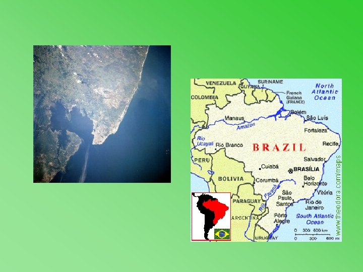
 Rio De Janeiro Brazil
 Demographics • Population: 6, 051, 399 • Ethnic Mix: 70% white, 20% black, 10% other • Religion: 75% Catholic, 25% other
 • Although Rio de Janeiro occupies a setting of magnificent natural beauty,") Demographics (continued) • Although Rio de Janeiro occupies a setting of magnificent natural beauty, poverty and urban sprawl have spawned the favelas, densely crowded neighborhoods of flimsy shacks. In contrast to the more affluent neighborhoods along the city’s southern beaches, favelas cover many of the city’s northern hills.
Demographics (continued) • Although Rio de Janeiro occupies a setting of magnificent natural beauty, poverty and urban sprawl have spawned the favelas, densely crowded neighborhoods of flimsy shacks. In contrast to the more affluent neighborhoods along the city’s southern beaches, favelas cover many of the city’s northern hills.
 Economics • Rio’s harbor is deep enough for the largest vessels to come alongside the wharves, which lie near the city center. • Through the port flows the major portion of Brazil’s imports and exports. • Rio is also a distribution center for the coastal trade.
 • The city’s manufactures include textiles, foodstuffs, household appliances, cigarettes, chemicals, leather") Economy (continued) • The city’s manufactures include textiles, foodstuffs, household appliances, cigarettes, chemicals, leather goods, metal products, and printed material. There also two major airports. • Rio’s climate is warm and humid and is a success by being a major tourist center.
Economy (continued) • The city’s manufactures include textiles, foodstuffs, household appliances, cigarettes, chemicals, leather goods, metal products, and printed material. There also two major airports. • Rio’s climate is warm and humid and is a success by being a major tourist center.
 History • Rio De Janeiro is a city of southeast Brazil on Guanabara Bay, an arm of the Atlantic Ocean. According to tradition, it was first visited in January 1502 by Portuguese explorers who believed Guanabara Bay to be the mouth of a river. • Therefore named the city Rio De Janeiro “River of January”.
 • It became capital of the colony of Brazil in 1763. •") History (continued) • It became capital of the colony of Brazil in 1763. • The Brazilian empire in 1822. • And of the independent country in 1889. • In 1960 the capital was transferred to Brasilia.
History (continued) • It became capital of the colony of Brazil in 1763. • The Brazilian empire in 1822. • And of the independent country in 1889. • In 1960 the capital was transferred to Brasilia.
 Significant Monuments/Markers • The Statue of Christ the Redeemer. Located at the top of Corcovado Mountain in Tijuca National Park. This great statue stands 2330 feet tall, holding the city of Rio in his arms. This is one of the most famous and most visited monuments in the world.
 • Sugar Loaf Mountain is one of the more spectacular tourist attractions") Significant Monuments/Markers(cont’d) • Sugar Loaf Mountain is one of the more spectacular tourist attractions in Rio de Janeiro. The two mountains of Sugar Loaf are located between Guanabara Bay and Copacabana beach in Rio de Janeiro. v The view from the peak of Sugar Loaf, 1, 296 ft (395 m) above sea-level
Significant Monuments/Markers(cont’d) • Sugar Loaf Mountain is one of the more spectacular tourist attractions in Rio de Janeiro. The two mountains of Sugar Loaf are located between Guanabara Bay and Copacabana beach in Rio de Janeiro. v The view from the peak of Sugar Loaf, 1, 296 ft (395 m) above sea-level
 Santiago, Chile
 Santiago’s Location
 History - settlement – Santiago began as a fortified encampment known as Santiago de La Nueva Extremadura. , it was the furthest outpost in the Spanish empire at the time. – Founded in 1541 by conquistador Pedro de Valdivia – Araucanian Indians destroyed the settlement and the Spaniards were besieged for two years. The eventual arrival of reinforcements from Peru enabled the city to be re-founded and Santiago settled
 Population growth • Late 1600 settlement of 200 houses, with about 700 Spaniards • Early 1900’s had a population of 30, 000 • 1950 1. 33 million • 1970 2. 84 million • 2005 6. 2 million (40% of Chile’s population)
 City Growth • In the beginning Haciendas or great farms were the background of the city • After independence from Spain in 1818, Santiago became capital of Chile and emerged as the most economically dynamic City of the new South American republics • Growth of the country's agriculture and mining industries served to boost Santiago's status and, throughout the 19 th and 20 th centuries, the city experienced large-scale immigration from Europe
 City Sprawl
 Economy • Leading producing and exporter of Copper. Accounts for ½ of country’s exports • One of three big financial centers in South America along with Buenos Aires and Sáo Paulo • Some Companies that have South American headquarters in Santiago: HP, Reuters, JP Morgan, Coca Cola, Intel, Motorola, Kodak, Nestle, and IBM
 Some Architecture
 More buildings …
 Santiago’s biggest problems Because of being located in a valley its geographic location is Unfavorable for air dispersal. To reduce air pollution the city has restricted the operation of motor vehicles, keeping 1/5 th of all vehicles in Santiago off the street each day. Government has also Offered incentives for heavy industry to move out of the city.
 Smog and Decentralization The government is now decentralizing Santiago due to its rapid and high growth rates. It is promoting out-migration to neighboring townships, the countryside, other cities and reducing in-migration to the city. It also has some of the best mass-transit systems to help reduce pollution. It has a clean and safe subway system, one of the most extensive Bus services, and plenty of taxicabs. All of these systems are being upgraded and improved to help with growth.
 Demographics Population growth rate: 1. 27% 6. 2 million *1. 27 = 75, 000 peeps per year Economic Growth Rate: 6% GDP increase projected for 2005 and 2006 Age structure: 0 -14 years: 28% 15 -64 years: 65% 65 years and over: 7% Ethnic groups: white and white-Amerindian 95%, Amerindian 3%, other 2% Religions: Roman Catholic 89%, Protestant 11%, Jewish Literacy: Total population: 95. 2% Those in Poverty: around 17%, down from recent years, but very high
 The capital of Brazil and model of urban planning
 Facts: • Brasilia was planned for only 500, 000 inhabitants, its population has grown much more than expected. • Due to zoning laws and the basic layout, the majority of the population lives outside the city limits in the 9 lower income satellite cities. • Brasilia was the most famous new capital cite of the twentieth century. • It is a land mark in the history of town planning. • The government constructed the city on an undeveloped site during the late 1950’s and the early 1960’s to encourage settlement in the inland regions of Brazil. • Ranked the 17 th largest metropolitan area in 1996.
 Demographics • • Ethnic Division: Caucasian = 55% Mixed Caucasian & Africans = 38% Africans = 6% Other = 1% Population: In 2005= 2, 176, 000 Population Growth Rate: 1. 28% Religion: Roman Catholic =70% Languages: Portuguese (official), Spanish, English, and French Male to Female Ratio: Males = 52% Females = 48%
 The Cathedral Metropolitan Monuments The head of Brazilian president Juselino Kubitschek. JK Memorial The Congress Juselino Kubitschek Bridge
 History • In the 18 th century, Brazil’s governing authorities decided to transfer the capital from Rio de Janeiro to an empty inland area safe from naval attacks. • They agreed to move the capital to Brasilia, which is a plateau carved out of the state of Goias. • Construction began in 1956 by landscape architecture Lucio Costa and was completed on April 21 st, 1960. • He used a “Pilot Plan”, which features two great intersecting axes. One for governmental and the other for residential, together they form a rough outline of an airplane. • East = Federal government buildings. • The central intersection of important boulevards = Bus terminals and hotels. • West = More hotels, a sports arena, and a recreational facility. • North and South = Residential areas, composed of six storied apartment buildings. Every fourth block there is a school, playground, shops, theaters, and more.
 • There are two major roadways in the city running east and west. The monuments and public buildings are located along the roadways. • The railroad runs north and south in a curving line, intersecting the bus terminal. • The goal was to use modern design and lots of land to contrast earlier cities, seen to be plagued by chaotic urban growth. • The city was seen to be sterile and overly controlled.
 Economics • Driven by the Federal Government, which employs most of the cities workers, with 42% in services, 31% in agriculture, and 27% in the industry. • Small scale industry, food services, and construction are also important. • Agricultural products include coffee, soybeans, wheat, rice, corn, sugarcane, cocoa, citrus, and beef.
 Positive Aspects: • The city is not threatened by any kind of natural disaster. • Good climate and sunny days are very common. • Many and large green areas in the pilot plan. • Virtually no air pollution. Negative Aspects: • It is not a walking city, the distance between building and sectors require a vehicle. • Housing prices are very high, compared to other Brazilian cities. • Public transportation is inefficient. • Very few people are found on the streets. • The newer satellite towns have very few green areas. • Many of the famous buildings are beautiful but not functional.
 Medellin, Antioquia
 Medellin • Capital of Antioquia, a province of northeastern Colombia, bordering Panama and the Caribbean Sea. • Located in the Aburra Valley, at an altitude of about 1, 500 meters. • The Rio Medellin River flowing northward, bisects the city. • The San Lucas Mts. and the Caucas River are located to the East of Medellin. • Medellin has an average annual temp. of 24 degrees C.
 Brief History • • • 1675: Medellin was founded. 1862: Medellin became the capital of Antioquia. 1951 -1973: Population of Medellin nearly quadrupled due to immigration from the countryside. 1970 -1980: Economy began to deteriorate. – Urban planning was unable to control urban growth and city expanded onto the slopes of the surrounding Aburra mountains. – Ongoing process of de-industrialization led to accelerated process of urban decay. 1980 -1990: Medellin became headquarters for Colombian drug cartel led by Pablo Escobar. – The drug cartels were tolerated by government because it helped attenuate economic crisis. The huge influx of money generated expectations of quick improvement in living conditions. – New migration pattern developed. Gated communities were built on the flat terrain in the city by rich. Poor moved out higher into the Aburra mountains. 1990 -2000: Crime and assassinations grew to an all time high. – The state finally made efforts to cut the power of the Medellin cartel. Led to civil war, government vs. drug cartel. Reputation of city suffered internationally, it became known for uncontrollable drugs and violence. – War ended with assassination of Pablo Escobar in 1993. – The city began to recover and rebuild itself.
 Important Information • Medellin is the second largest city in Colombia. • It has a population of almost 2 million people. • Ethnic groups: Mestizo 58%, white 20%, mulatto 14%, black 4%, mixed black-Amerindian 3%, Amerindian 1%. • Major exports: coffee, cut flowers, petroleum, coal, apparel, and bananas. • Medellin has a literacy rate of 91. 3%. • Spanish is the dominant language, and Roman Catholic is the main religion. • Best known event is the Flower Festival, where citizens celebrate the cut flower business, which supplies around 70% of the flowers imported by the U. S.
 Transportation • One of the major improvements for transportation in Medellin was the addition of the Medellin Metro. • Built in 1995, it was actually the first subway to be built in Colombia. • The main airport serving Medellin, is the Jose Mario Cordoba International Airport.
 Medellin and Pablo Escobar • Pablo Escobar is one of the most notorious names associated with Medellin. • His drug cartel penetrated the economic, socio-cultural, and political spheres of the city. He practically owned Medellin in the 80’s. • Estimates are that his drug cartel was taking in an estimated $25 billion annually in the 80’s. • Seen as a type of Robin Hood to the people of Medellin. He built stadiums and gave money to the poor. In return they served as lookouts and hid information from the authorities. • Once estimated by Forbes magazine to be the seventh-richest man in the world, with Medellin cartel controlling 80% of the world’s cocaine market. • In 1991, Escobar turned himself in for fear of extradition to the U. S. • Escobar was killed in 1993 after he escaped from prison.
 Medellin Today • • • Today, Medellin is experiencing an urban and economic renaissance. In 2003, 1. 2 million square meters of property were developed into hotels, new housing, and office buildings. The city’s transportation network is a model for the rest of the Andes. Universities and hospitals are top tier, with doctors being credited for such triumphs as the first kidney transplant in Latin America. The city still experiences crime, but nowhere near as bad as past decades. The 2 million residents of Medellin have never been more prosperous, with profits from exports triple what it was in the 90’s.
 Salvador, Brazil
 Salvador - History • • • Founded in 1549 by Portuguese settlers led by Thome de Souza. Salvador was the major port of Brazil during the Portuguese colonial rule, leading in sugar export and slave trade. Salvador was the first capital of Brazil until 1763 when Rio de Janeiro took its place. Seat of the 1 st Catholic Bishop of Brazil in 1552, and is still an ecclesiastical center of power for Brazilian Catholicism. 1583 Salvador’s population was at 1600, making it one of the largest cites of the New World at the time. Even at the time of the American Revolution in 1776 Salvador’s population was greater than any American colonial city. The Church of Saint Francis • • 1624 Salvador was taken by the Dutch, but soon recaptured by the Portuguese the next year. Salvador was also the center for the Brazilian independence movement. On September 7 th, 1882, liberation was attained. 1948 population was 340, 000 1991 population was 2. 08 million
 Salvador - Geography • • • Salvador is located on a Peninsula on the Atlantic in northeast Brazil. The city is on the Baia de Todos os Santos, or “The Bay of All Saints. ” The topography is predominately hill and valley. Salvador is also at the heart of Reconcavo Baiano metropolitan region. One of the distinct features of the city is that it is separated into two parts, an “upper city” (cidade alta) and a “lower city” (cidade baixa). This is due to an actual difference in elevation. The upper city is located on a “bluff” 230 ft above the lower city.
 • • • The lower city is on the waterfront") Salvador – Geography (continued) • • • The lower city is on the waterfront and therefore is the commercial and financial sector of the city. There are docks and warehouses and also a naval base located there. The upper city is the historic sector of the city, containing administrative buildings, cathedrals and colonial architecture. Passage between the two is made by cable railways, winding roads, and a vertical pedestrian lift known as the Lacerda Elevator.
Salvador – Geography (continued) • • • The lower city is on the waterfront and therefore is the commercial and financial sector of the city. There are docks and warehouses and also a naval base located there. The upper city is the historic sector of the city, containing administrative buildings, cathedrals and colonial architecture. Passage between the two is made by cable railways, winding roads, and a vertical pedestrian lift known as the Lacerda Elevator.
 Salvador - Economy • • Before the Brazilian Independence in 1823, Salvador was a major industrial and port city. In Brazil it was the center for trading sugar and tobacco, and also the slave trade during the Portuguese colonial era. Today the port still plays a major role in the economy, exporting cacao, sisal, soybeans, and petrochemical products. Also its role as an industrial city has declined, the local industries still include fishing, oil and gas extraction, cigar manufacture, an oil refinery, and tourism. Ford Motor Company has a plant in the metro area.
 • • • Markets are also tourist attractions in Salvador,") Salvador – Economy (continued) • • • Markets are also tourist attractions in Salvador, such as Sete Portas and Mercado Modela. • • Salvador today is attracting increasing numbers of tourists because of its setting. Also, in the 1990 s, the Bahian state government restored the Pelourinho district, which is located in the historic sector of the city in efforts to increase tourism further. Northeast Brazil is an impoverished area with high birth rates and infant fatality rates. Salvador is no exception. Salvador had high crime and unemployment rates. The average monthly income in the 1990’s was equivalent to 447 dollars. Sanitation had also been a problem in the poorer neighborhoods of Salvador. 1/3 of people have no sewage hookups or septic systems.
Salvador – Economy (continued) • • • Markets are also tourist attractions in Salvador, such as Sete Portas and Mercado Modela. • • Salvador today is attracting increasing numbers of tourists because of its setting. Also, in the 1990 s, the Bahian state government restored the Pelourinho district, which is located in the historic sector of the city in efforts to increase tourism further. Northeast Brazil is an impoverished area with high birth rates and infant fatality rates. Salvador is no exception. Salvador had high crime and unemployment rates. The average monthly income in the 1990’s was equivalent to 447 dollars. Sanitation had also been a problem in the poorer neighborhoods of Salvador. 1/3 of people have no sewage hookups or septic systems.
 Salvador - Culture • One of Salvador’s distinguishing characteristics is its presence of colonial architecture in the Upper City. One of the buildings located there is a cathedral, still standing from the year 1572. Many other Baroque-style churches are also located there.
 • • • 15 Forts from the colonial period are") Salvador – Culture (continued) • • • 15 Forts from the colonial period are also still standing in Salvador is also known for the influence of African culture on the city. Candomble is an Afro-Brazilian religion practiced in Salvador. The city has over 1000 Candomble temples – called terreiros. The Afro-Brazilian martial dance of capoeira is also popular in Salvador has over 350 churches • and has been called “Black Rome. ” The Carnaval celebration in Salvador is also a tourist attraction. Many visit to experience the circus and public street parades and parties that happen before Lent. Distinct areas of Salvador are also tourist attractions such as Pelourinho, and the tourist market Mercado Modela. Pelourinho district was built when the city was the economic powerhouse of South America, and the buildings reflect the wealth of the city at the time.
Salvador – Culture (continued) • • • 15 Forts from the colonial period are also still standing in Salvador is also known for the influence of African culture on the city. Candomble is an Afro-Brazilian religion practiced in Salvador. The city has over 1000 Candomble temples – called terreiros. The Afro-Brazilian martial dance of capoeira is also popular in Salvador has over 350 churches • and has been called “Black Rome. ” The Carnaval celebration in Salvador is also a tourist attraction. Many visit to experience the circus and public street parades and parties that happen before Lent. Distinct areas of Salvador are also tourist attractions such as Pelourinho, and the tourist market Mercado Modela. Pelourinho district was built when the city was the economic powerhouse of South America, and the buildings reflect the wealth of the city at the time.
 Salvador - People and Places • Dorival Caymnil • Gal Costa • Gilberto Gil – equivalent in Brazil to John Lennon or Paul Mc. Cartney in the U. S. He is a Grammy Winner and the current Minister of Culture in Salvador. • All MPB (Musica Popular Brasileira) stars. • Ruy Barbosa • Antonia de Castro Alves, a poet • Jorge Amado, a novelist • • Jorge Amado, a novelist State University of Bahia Catholic University of Salvador Lacerda Elevator – vertical pedestrian lift built in 1873. Replaced in 1928 and now transports 50, 000 people daily between the upper and lower cities. Church of St. Francis Church of Third Order of St. Francis Afro-Brazilian Museum. Fort of St. Anthony of Barra – built in 1580
 Salvador – Important Facts • Also known as Bahia for a long time. • 4 th largest city in Brazil • Salvador had a population of 2, 631, 831 people in 2004. • Major religions are Catholicism, Candomble, Protestantism, Espiritism, and recently Mormons. It is common for individuals to practice pieces of more than one religion. • Salvador’s population has been growing as country-side dwellers move into the city. • Brazil’s oldest city. • 450 th Birthday in 2000. • Gross Domestic Product per capita: 4, 309 Reals. • Gross Domestic Product: 10, 738, 802 thousand Reals. • Making up most of the GPD is services with 8, 229, 247 thousand Reals.
 Sao Paulo, Brazil
 History of Sao Paulo • The city was founded in 1554 by Jesuit Missionaries • Later was established as a simple urban outpost for coffee barons up until the 20 th century • Officially became a city in 1711 • Many immigrants from Japan, Germany, Italy, Arabia, and Spain came to work at the large coffee plantations scattered through the city • Sao Paulo grew in industrial strength around the turn of the century which caused the city to expand rapidly due to immigration
 Economic and Political Systems • • • Sao Paulo has a diverse economy centered around its large industrial and commercial center Close to one half of the country’s industrial output comes from the city of Sao Paulo State accounts for over ¾ of the country’s output of machinery, electrical goods, and rubber Democratic government with one president, very similar to the United State’s Political system Luiz Inácio da Silva is the current president
 Demographics • The city has an area of 575 sq. miles • A population of 10. 9 Million • Largest city in Brazil (near second largest in the world based on population) • 20 million people live in the greater metropolitan area of Sao Paulo
 Social Aspects • Sao Paulo is home to the University of Sao Paulo • Has a major art museum known as MASP • Major symphonic orchestra known as OSESP • Grand Prix race track called Interlagos • World’s largest private-owned sports stadium • Sao Paulo also takes part in the Carnival celebrations that go on all throughout South America (much like Mardi Gras)
 Entertainment • Many shopping malls such as Shopping Morumbi, Sao Paulo Marketplace, Shopping Eldorado, and Jardin do Sul • Embu is a nearby city with many street vendors who sell a diverse array of art • Chohoscorias are famous for their barbeque type menu and unique setting
 Poverty in Sao Paulo • Sao Paulo has a major problem with Poverty • Approximately 1, 500, 000 people now live in favelas (shanty towns) in Sao Paulo and surrounding areas • Crime has suddenly increased, and kidnappings and robbery are relatively common in the city
 Ethnic Groups in Sao Paulo • Of the approx. 11 million people in Sao Paulo the breakdown is as Follows: • 3 million descendents of the Portuguese • 3 million descendents of Italian • 3 million descendents of African heritage • 1 million Japanese (largest pop. Outside of Japan) • 1 million German
 Rapid Population Growth • From a population of merely 32, 000 people in 1880, Sao Paulo has grown considerably in the last century • In 1980, the population was at 8. 5 million • Today, the population is close to 11 million • Urban sprawl is evident in the first slide with the picture of Sao Paulo taken by satellite
 Santa Cruz, Bolivia
 Where is it? Santa Cruz lies 416 meters above sea level and is located in central Bolivia near the Piray River, in the tropical llanos (plains) region east of the Andes Mountains.
 History of Santa Cruz • The land where Santa Cruz was founded on was inhabited by the ancient Aymará civilization, who lived on Lake Titicaca. Later, this civilization was conquered by the Incas, who were themselves conquered by the Spanish in 1538. Throughout the country’s colonial history, it was known as Upper Peru. Simon Bolivar led the country to independence in 1825. In its early years, independent Bolivia was ruled by a succession of caudillos (military dictators) who tried, with mixed success, to integrate the country’s three disparate regions – the central region, the eastern Andes and the Altiplano – into a national entity. • The city of Santa Cruz de la Sierra was founded by Ñuflo de Chávez on February 26, 1560.
 Important Facts • Total Population: 1, 364, 389 • Full Name of the city is Santa Cruz de la Sierra • It is the Capital of the Santa Cruz Department(or State) • Is considered the fastest growing city in Bolivia
 Economy • Santa Cruz is a trade and processing center for sugar, rice, cotton, fruit, soy, and corn. • Has a strategic and commercial importance because of its central location. • There also natural-gas reserves and an oil refinery nearby. • Important industries are leather crafting, sugar refining, and alcohol production. • A rail line gives the city access to both the Atlantic and Pacific oceans.
 • • • Culture The predominant religion is Roman Catholic, but there is a scattering of other Christian faiths. Indigenous Bolivians, however, have blended Catholicism and their traditional beliefs. An example is the near synonymous association of Pacha Mama (Mother Earth) and the Virgin Mary. Spanish is the official language throughout Bolivia, although only 6070% of the population speaks it, and then often as a second language. The indigenous languages of Quechua and Aymara are the preferred languages. When bargaining in rural markets, a Quechua word or two will not only endear you to the vendors, but usually get you an extra orange or more juice! Several other small indigenous groups speak their own languages. English is understood in the best hotels and in airline offices and travel agencies, but it's of little use elsewhere. Bolivian food consists mainly of meat, corn pancakes, rice, eggs and vegetables. Local specialties include pique a lo macho, grilled beef and sausage; lechón, suckling pig; and cuy, whole roasted guinea pig-however, some delicacies may only be for the most adventurous stomachs. • Religious Affiliations of the population of Santa Cruz • • • Catholic: 1, 046, 463 - 76. 6% of the city’s population Evangelical: 136, 993 Others: 14, 505 None: 28, 564 Not Specified: 100, 512
 Major Landmarks/Attractions • Piraí River: The riverbanks are often the spot for weekend picnics. • Municipal Zoo: One of the best zoos in South America, features birds, reptiles, mammals, from the region as well as endangered and exotic species. • Plaza 24 de Septiembre: Ideal for relaxing and watching sloths hanging in the tall trees. • The Cathedral: Located on the Plaza 14 de Septiembre, the cathedral dates back to the early 1600's. The cathedral museum displays religious art work, gold and silver artifact from the Jesuit missions. • Museo de Historia Natural: Display a collection of flora and fauna of the region.
 • Lomas de Arena de El Palmar: Located 16 Km south of") Landmarks (Continued) • Lomas de Arena de El Palmar: Located 16 Km south of Santa Cruz these large sand dunes and fresh water lagoons are ideal for weekend picnics and swimming. • Parque Nacional Noel Kempff Mercado: Really worth seeing, this spectacular natural park, about 440 Km northeast of Santa Cruz, has an incredible scenery of waterfalls, rivers, rainforests and a wide variety of flora and fauna (alligators, pink dolphins, caimans, river otters, tapirs, spider monkeys, etc. ). • Jesuit Missions: From Santa Cruz, east across the Río Grande, this circuit of Jesuit missions. founded between 1696 and 1760, composed by the mission of San Javier, San Ramón, San Ignacio, Concepción, San Rafael, Santa Ana, and San José de Chiquitos were declared "World Heritage" by the UNESCO World Heritage Committee on December 12, 1990 in Alberta, Canada. • El Fuerte de Samaipata: (Fortress) 120 Km southwest from Santa Cruz, the entire Inca ruins complex of around 40 hectares was declared "World Heritage" by the UNESCO World Heritage Committee on December, 2 nd 1998 in Kyoto, Japan.
Landmarks (Continued) • Lomas de Arena de El Palmar: Located 16 Km south of Santa Cruz these large sand dunes and fresh water lagoons are ideal for weekend picnics and swimming. • Parque Nacional Noel Kempff Mercado: Really worth seeing, this spectacular natural park, about 440 Km northeast of Santa Cruz, has an incredible scenery of waterfalls, rivers, rainforests and a wide variety of flora and fauna (alligators, pink dolphins, caimans, river otters, tapirs, spider monkeys, etc. ). • Jesuit Missions: From Santa Cruz, east across the Río Grande, this circuit of Jesuit missions. founded between 1696 and 1760, composed by the mission of San Javier, San Ramón, San Ignacio, Concepción, San Rafael, Santa Ana, and San José de Chiquitos were declared "World Heritage" by the UNESCO World Heritage Committee on December 12, 1990 in Alberta, Canada. • El Fuerte de Samaipata: (Fortress) 120 Km southwest from Santa Cruz, the entire Inca ruins complex of around 40 hectares was declared "World Heritage" by the UNESCO World Heritage Committee on December, 2 nd 1998 in Kyoto, Japan.
 Pictures
 Buenos Aires, Argentina
 About Argentina • 21 Provinces • 4, 466, 896 sq. mi. • Population of 37 Million • 11 Million of which are in Buenos Aires • “Pampas” fertile farming ground
 Brief History • 1536 - Founded by Spaniards looking for Gold • 1580 - Permanent Spanish Settlement • 1617 - Given its own Governor in and had provincial status • 1776 - Capital of New Viceroy controlled Territory • 1810 - Severed from Spanish Empire, establishes its own government • 1862 - Capital of Argentina • 1880 - Federalization, Beginnings of Urbanization
 Important Factors • Most European of all Latin American Cities • Known as the “Paris of South America” • Wide Boulevards, Leafy Parks, Grand Architecture, and lots of Monuments • 47 barrios, each one with its own distinct flavor and culture
 Porteños Population Population Area Sq. Mi. Pop. Per Sq. Mi. Capital Federal- 2, 904, 000 77 37, 638 Inner Suburbs 5, 202, 000 360 Outer Suburbs 3, 094, 000 633 Urbanized Area 11, 200, 000 14, 436 4, 886 1, 070 10, 467 Buenos Aires is ranked 4 th in the world’s highest urban populations, behind only Shanghai, Bombay, and Karachi. When considering metropolitan area however, it falls to 17 th.
 Maps
Maps
 Demographics • Only. 05% inhabitants of Buenos Aires are of Native Decent • Most Porteños are of Spanish or Italian Decent, though there also sizeable percentages of German, Arab, Jewish, Armenian, Anglo-Irish, Korean, Japanese, and Chinese • Italian and German names outnumber Spanish ones • 96% Catholic
 Economy • Buenos Aires is the financial, industrial, commercial, and cultural hub of Argentina. Its port is one of the busiest in the world; navigable rivers connect it to the Argentine North-East, Brazil, Uruguay and Paraguay. As a result, it serves as the distribution hub for a vast area of the south-eastern region of the continent. • Agricultural products such as meat, grain, dairy, tobacco, wool, and hide from pampas. • Industries include automobile manufacturing, oil refining, metalworking, machine building, and the production of textiles, chemicals, clothing, and beverages.
 Government • Political Instability from 1945 -1983 • La Guerra Sucia and the 10, 000 -30, 000 Disaparecidos • Distrust in National Government • Today Three Branch style similar to US • Gobernador Felipe Solá
 Population Reference Bureau
 Thank you very much, that’s all for me.
 Bogotá, Colombia
 Origins • Founded in 1538 by Jimenez de Quesada as capital of New Granada • Was known as the “Athens of America” • Jose Acevedo y Gomez led the first successful revolt in 1810. • After Bolivar’s decisive victory in 1819, Bogotá became the capital of Greater Colombia.
 Origins, cont. • When the country divided in 1830, Bogotá became the capital of what we know today as Colombia. • Much of the city was damaged by rioting in 1948, after the assassination of radial leader Jorge Eliecer Gaitan. • In 1955 Bogotá and the surrounding area were organized as a “Special District”, which became the “Capital District” in 1991.
 Demographics • Population of roughly 7. 8 million people • Located at altitude of 8660 feet above sea level at the base of two mountains in the Northern Andean Range. • Population is currently increasing at rate of 5% per year, mostly due to rural residents flocking to the city. • Currently, the urban area covers 384. 3 square kilometers.
 Religions • 97% Christian – Other religions observed include: • • Islam Judaism Primal/Indigenous Secular
 Economy • Bogotá is Columbia’s largest economic center, and it’s residents refer to Bogotá as Colombia’s “first city”. • It is home to most foreign companies doing business in Colombia, as well as Colombia’s main stock market. • Three largest sectors of Bogotá’s economy are the export of coffee, emeralds, and flowers.
 More on the Economy… • Colombia’s coffee is prized as the finest in the world, and it is the world’s largest producer of the product. • In downtown Bogotá, millions of dollars of domestically produced rough and cut emeralds are bought and sold daily • As much as 55% of all flowers sold in the United States are imported from Colombia.
 Culture • Bogotá is home to several universities: – Universidad del Rosario, the oldest in Colombia – National University of Colombia – Los Andes University – Pontifical Javerian University – Universidad Externado de Colombia – University of Santo Tomas
 Festivals • Festival Iberoamericano de Teatro – Most important theatre festival in Latin America and Spain. • Bogotá’s Half-Marathon – International marathon that takes place between June and August, with 200 million pesos in prizes • La Candelaria – A neighborhood of Bogotá where a great number of cultural events occur. It is home to several of Bogotá’s universities.
 Transportation • Bogotá is a modern city with a modern transportation system consisting of: – Airlines – Busses – Taxis – The Transmilenio – A train that serves the outskirts of the city