

5173e3708a824175347e793784e31d25.ppt
- Количество слайдов: 43
 CEE 795 Water Resources Modeling and GIS Lecture #3: Data Sources and Projections (some material from Dr. David Maidment, University of Texas) January 30, 2006 Learning Objectives: • List the essential data needed for water resource modeling • Identify sources of water resources data in the U. S. and Clark County Handouts: Assignments: Exercise #2
 Geospatial One-Stop http: //www. geodata. gov/gos
 Google Earth http: //earth. google. com/
 Watersheds of the US 2 -digit water resource regions 8 -digit HUC watersheds
 Hydrologic Unit Code Watersheds ~ 2000 for US, about the size of counties
 Watershed Hierarchy Digit # 2 4 6 8 HUC 10 12 EDNA Available In Progress
 • Boundaries for") Watershed Boundary Dataset • National Program by USGS and USDA (NRCS) • Boundaries for 10 - and 12 - digit watersheds • First cut is by automated delineation from NED • Hand checked and edited 10 -digit watersheds
Watershed Boundary Dataset • National Program by USGS and USDA (NRCS) • Boundaries for 10 - and 12 - digit watersheds • First cut is by automated delineation from NED • Hand checked and edited 10 -digit watersheds
") EPA River Reach File 1 (RF 1)
EPA River Reach File 1 (RF 1)
 BASINS - Integrating GIS and Water Quality Modeling Data State and Local Data Cartographic Monitoring Tools Target Assess DM Models HSPF - NPSM QUAL 2 E Assessment TOXIROUTE Loadings Decisions Data Mining Reporting Watershed Management. TMDL Post-Processors . Source Water Protection. Stormwater
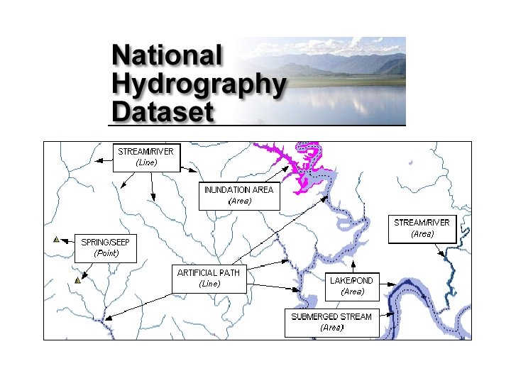
 River networks for 8 -digit HUC watersheds http: //nhd. usgs. gov/
 Lower West Fork, Trinity River Basin HUC = 12030102
 NHD River Reaches 412 River Reaches In Upper West Fork of Trinity Basin
 River Reach Codes Used for river address locations Reach. Code = 12030102000151 Reach. Code = 12030102000005 HUC# Segment# Location 0. 392 on Reach 12030102000005
 National Elevation Dataset http: //gisdata. usgs. net/ned/ • Digital Elevation Model with 1 arcsecond (30 m) cells • Seamless in 1° blocks for the United States • 10 billion data • Derived from USGS 1: 24, 000 quadrangle sheets Get the data: http: //seamless. usgs. gov/
 720 Contours 740 720 700 680") Digital Elevation Model (DEM) 720 Contours 740 720 700 680
Digital Elevation Model (DEM) 720 Contours 740 720 700 680
 Austin West 30 Meter DEM
 http: //www. ngdc. noaa. gov/mgg/shorelines. html
 1: 250, 000 Scale Soil Information http: //www. ncgc. nrcs. usda. gov/products/datasets/statsgo/
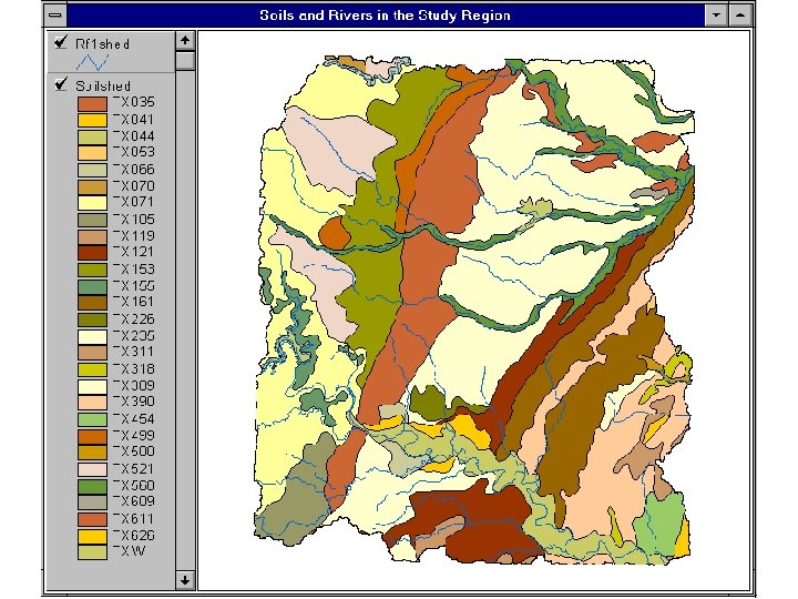
 1: 24, 000 scale soil information County Level Digital Soil Maps http: //www. ncgc. nrcs. usda. gov/products/datasets/ssurgo/
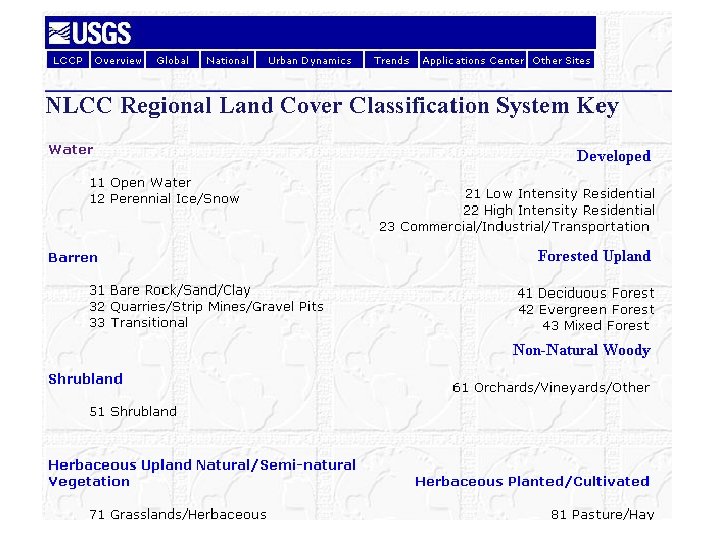
 National Land Cover Dataset http: //landcover. usgs. gov/nationallandcover. html Get the data: http: //seamless. usgs. gov/
 Hydrologic Landscape Regions USGS Characterization of nature of soil and groundwater systems
 http: //www. ncdc. noaa. gov/oa/ncdc. html
 PRISM Mean Annual Precipitation http: //www. wcc. nrcs. usda. gov/climate/prism. html
 http: //www. daymet. org/
 National Water Information System Web access to USGS water resources data in real time http: //waterdata. usgs. gov/usa/nwis/
 USGS Water Watch Web access to USGS water resources data in real time http: //waterdata. usgs. gov/nwis/rt
 USGS National Water Information System. • Real-time and Historic Data – – Streamflow and stage Groundwater levels Water Quality Site information • Tabular or Graphical Format
 http: //srtm. usgs. gov/
 http: //www. geographynetwork. com/
 GTOPO 30 - 1 km Digital Elevation Model of the Earth http: //edcdaac. usgs. gov/gtopo 30. html
 Drainage in North America Hydro 1 K is derived from GTOPO 30 using raster GIS analysis http: //edcdaac. usgs. gov/gtopo 30/hydro/index. html
 NASA Satellite Data http: //edcimswww. cr. usgs. gov/pub/imswelcome/
 Global Energy and Water Experiment http: //www. gewex. org/
 http: //maps. utah. gov/
 http: //www. wrcc. dri. edu/
 http: //www. wcc. nrcs. usda. gov/snotel/
") Clark County Data • Clark County GIS Management Office (GISMO)
Clark County Data • Clark County GIS Management Office (GISMO)
 Clark County Data • Flood Threat Recognition System