

3c7f76d38dc199cd472c1cdb698c7f53.ppt
- Количество слайдов: 48
") CE S Disaster Management Support Group CHAIR, HELEN M. WOOD (NOAA)
CE S Disaster Management Support Group CHAIR, HELEN M. WOOD (NOAA)
 includes : · 21 space") CE S The Committee on Earth Observation Satellites (CEOS) includes : · 21 space agency Members operating satellite Earth observation systems (or having a significant contribution to such systems). · 20 Associates including international organizations, international research programmes, operational observing systems, and government agencies with significant ground systems CE S
CE S The Committee on Earth Observation Satellites (CEOS) includes : · 21 space agency Members operating satellite Earth observation systems (or having a significant contribution to such systems). · 20 Associates including international organizations, international research programmes, operational observing systems, and government agencies with significant ground systems CE S
 CE S Objectives CEOS has three primary objectives : • To optimize the benefits of spaceborne Earth observations; • To serve as the focal point for international coordination of space-related Earth observations activities; • To exchange policy and technical information to encourage complementarity and compatibility among spaceborne Earth observations systems. CE S
 Goal: To derive greater benefit from operating and planned observing systems
 Concept of an IGOS International and national scientific, social, economic, and political drivers Redesign systems Evaluate capabilities of observation al systems Assess Requirement s for observations Monitor progress Assess implementati on of systems Evaluate usefulness of products Implementatio n Use resultan t product s (from Williams and Townshend, 1998) Collect observatio ns and generate products Decide what needs to be changed Obtain commitment s for change Change the observational systems Enhance the product processing chain Deploy improved observational assets and improve use of existing ones
 IGOS Pilot Projects The six IGOS prototype pilot projects selected by the Strategic Implementation Team are the following: · Global ocean data assimilation experiment · Upper air measurements · Long-term continuity of ozone measurements · Global observation of forest cover · Long-term ocean biology measurements · Disaster management support
 Disaster Management Support Group Objective: To support natural and technological disaster management on a worldwide basis, by fostering improved utilization of existing and planned Earth observation satellite data
 Earthquakes ERS-1 SAR: Landers Earthquake GPS: Monitoring Southern California
 Interferometric SAR
 Tromsø Satellite Station Oil Spill Products
 - ID with Quik. SCAT,") Mammoth Iceberg B 10 -A (24 x 48 mi) - ID with Quik. SCAT, 8/99 - Near Drake Passage - RAF Photos (Falklands Met Office) 9/3/99, 5928 S/5845 W
Mammoth Iceberg B 10 -A (24 x 48 mi) - ID with Quik. SCAT, 8/99 - Near Drake Passage - RAF Photos (Falklands Met Office) 9/3/99, 5928 S/5845 W
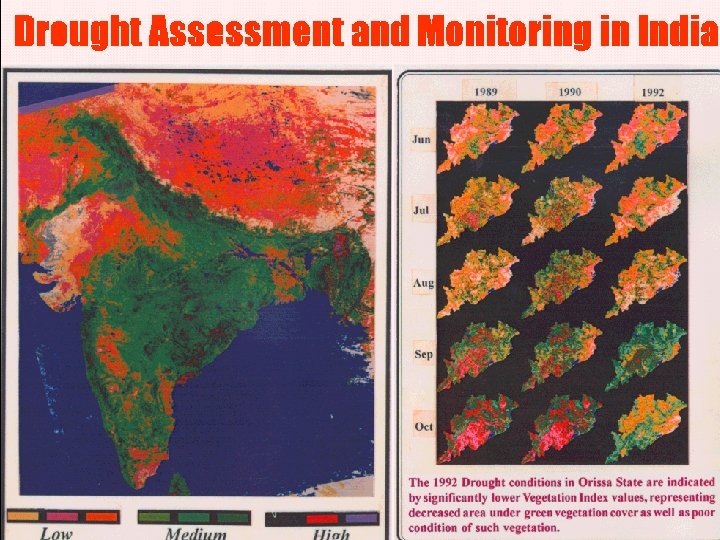
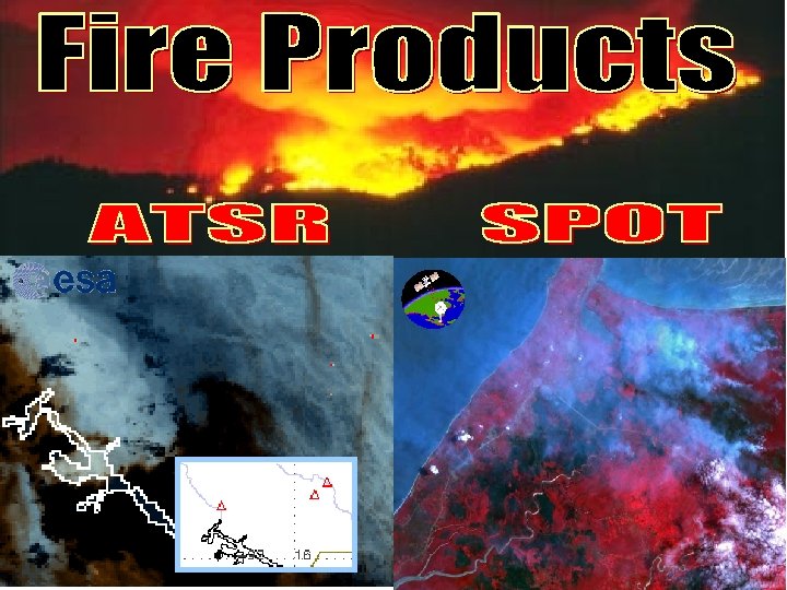
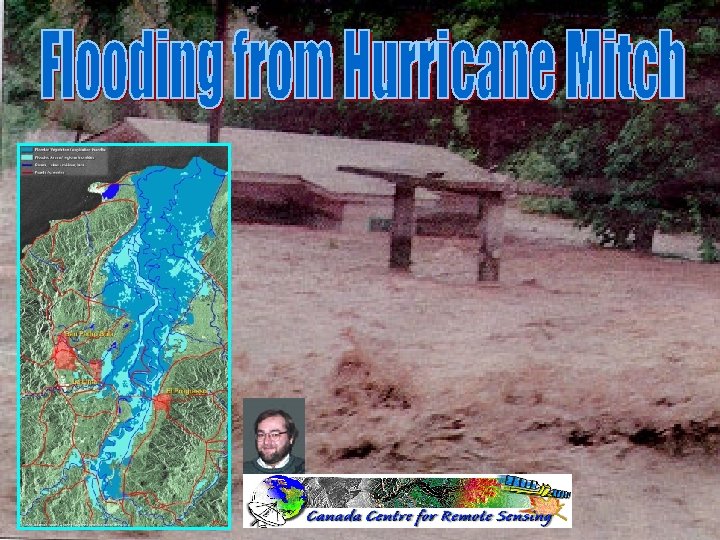
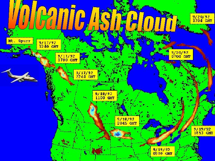
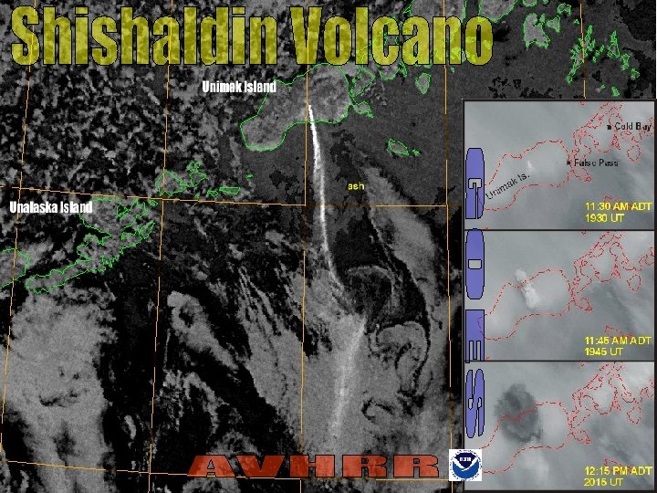
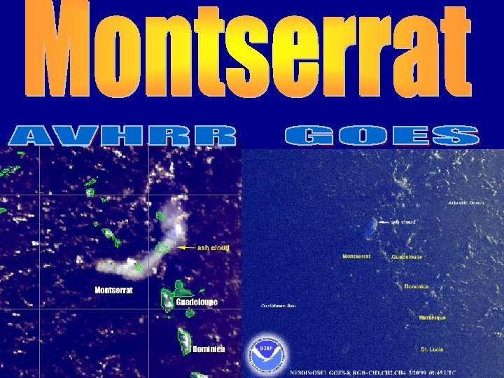
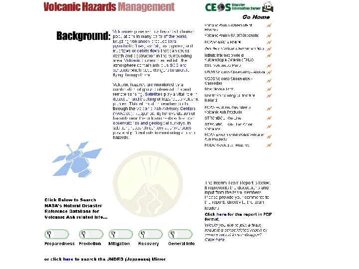
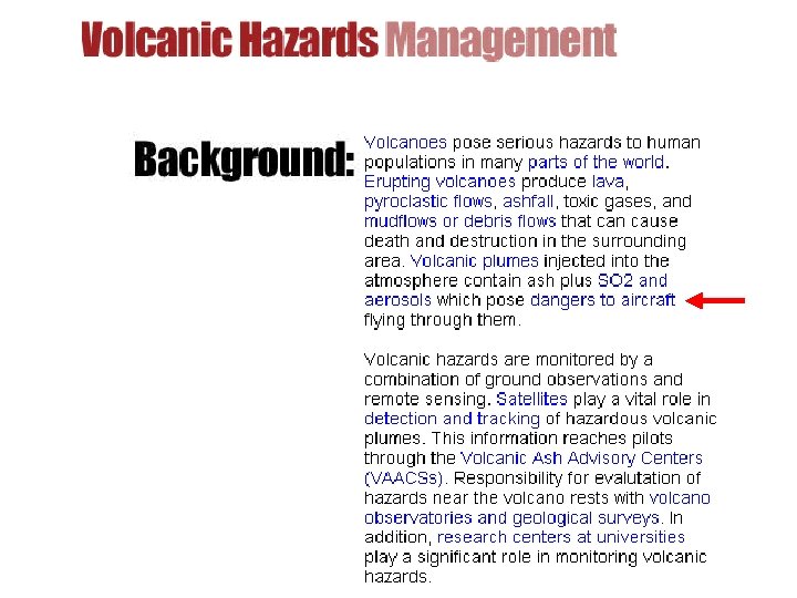
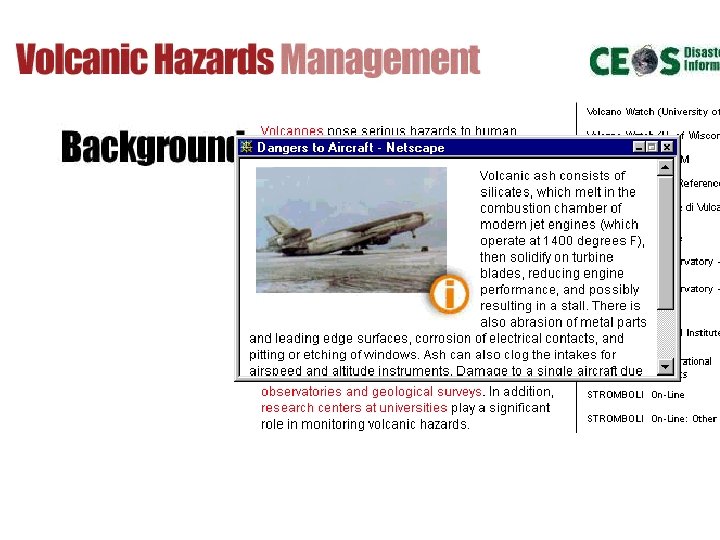
 Hazard Team Coordinators Drought NRSA/India, U. of Freiburg/Germany Earthquake ESA Fire USDA, UNEP Flood CCRS, NOAA Landslide CCRS Oil spill NRSC/UK Volcanic hazards NOAA, USGS, U. of Reading/UK
 Approach · Work with emergency management users with broad geographical responsibilities · Formalize requirements definition · Assess current/planned capabilities · Expand user outreach · Provide support tools · Use lessons learned
 Dimensions of Disaster Management To identify requirements, we need to map a multi-dimensional matrix: - Spatial requirements - Temporal requirements - Frequency of observations - For each disaster type - For each disaster phase - For each sensor type Building on the work of CEOS and disaster agencies
 Dimensions of Disaster Management User Level Disaster Management Category Activity Status International Mitigation Research Regional Preparedness (Warning) Demonstration National Relief/Recovery Operational State Local Other User Services
 Information Delivery · Tools to ease access to data and derived information products · Users need tailored information products · Training and education required · Special need for developing countries
 http: //disaster. ceos. org
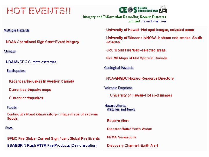
 Current Significant Global Fire Events--Forest Fires in Canada Events") Global Fire Monitoring Center (GFMC) Current Significant Global Fire Events--Forest Fires in Canada Events Saskatchewan Environment and Resource Management
Global Fire Monitoring Center (GFMC) Current Significant Global Fire Events--Forest Fires in Canada Events Saskatchewan Environment and Resource Management
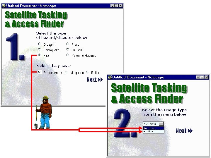
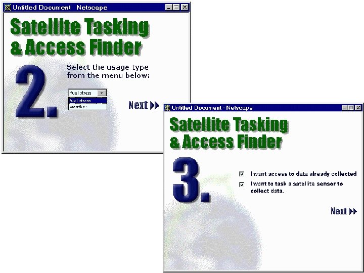
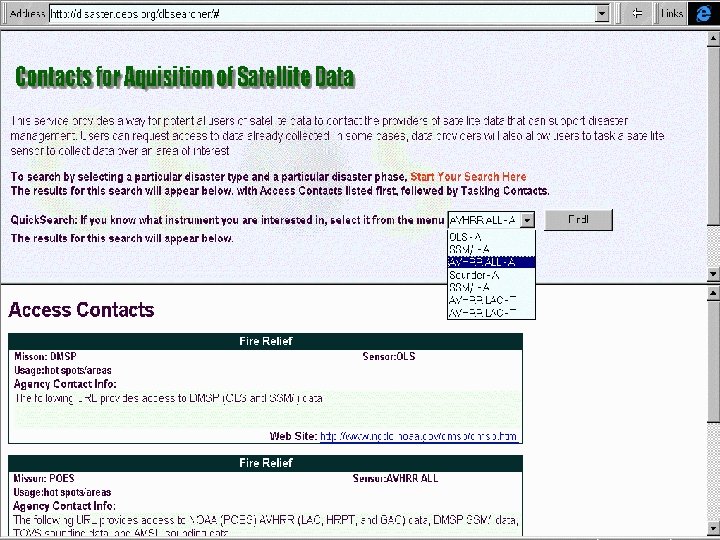
 INTEGRATED DATA ACQUISITION · What’s useful? · What’s available? · How do I get it? · Where can I get it? · How do I order it?
 Overarching Recommendations
 Overarching Recommendations ? The space sector should be pro-active in responding to the receptiveness of the disaster management and response community ? In order to promote wider acceptance and use of space systems by disaster management users, the space and services communities must create the appropriate tools and continue to perform compelling demonstrations.
 Overarching Recommendations ? The space agencies and applications community should invest in familiarizing themselves with the needs of the disaster management users and work together to smooth the transition from research capabilities to operations.
 Overarching Recommendations ? Recognizing the reluctance and lack of familiarity of some users to the use of satellite data, effort must also be made to be as accurate as possible in describing what spacebased observations can and cannot do. One should not oversell, but at the same time, one should not understate the true value of remote sensing.
 Overarching Recommendations ? Space agencies should address each of the following critical factors on its own merits because user acceptance does not necessarily increase by trading one factor off against another. CTimeliness CCost CAccessibility CEase of use CReliability CRepeaetability CDemonstrated operational capability
 Overarching Recommendations ? CEOS agencies should work together to advance common data policies, where possible, to facilitate ready, affordable access to Earth observation satellite data for emergency use. ? (The data charter, announced at UNISPACE-III by ESA and CNES, may provide a starting point for such a policy. )
 Overarching Recommendations ? CEOS agencies should work to support rapid satellite tasking of Earth observation missions to enhance the utility of space for disaster applications. ? CEOS agencies should work to support fast processing and delivery of data, which will also be very important in determining the utility of space data for disaster applications.
 Overarching Recommendations ? Initial steps should be taken in the sharing of technical information and development of tools for satellite tracking and tasking that are more user friendly for disaster management support purposes. ? Mirroring of information currently contained on the project information server may be a productive operational demonstration of this concept.
 Overarching Recommendations ? There is a need to integrate non-space information with space imagery and other satellite data, including the use of appropriate geographic information system tools, to facilitate integrating those data quickly in a seamless fashion.
 Overarching Recommendations ? It is recognized that each team and the project in general must continue to reach out for broader geographic and disciplinary representation, especially in terms of interacting with specific users to determine their desired information needs.
 Meeting Schedule Place Brussels, Belgium Tokyo, Japan London, England Bangalore, India Silver Spring, USA Frascati, Italy Montreal, Canada Tsukuba, Japan Silver Spring, USA Paris, France Hawaii, USA Tokyo, Japan Ottawa, Canada Time May 97 July 97 September 97 October 97 March/April 98 September 98 October 98 January 99 June 99 September 99 February 00 June 00 Host EC NASDA BNSC ISRO NOAA ESA CSA NASDA NOAA CNES/ESA NOAA NASDA CCRS
 Council of Europe Utsunomiya Univ. EC/DG 11, DG 12 RPA PLANETA JAMSTEC RSSIC SCOT CONSEIL Tokai Univ. Anite Systems DIA/NIAES Freiburg Univ. HD/MSA Reading Univ. RESTEC EUMETSAT NASDA Fisheries & Oceans SMC NPA Group PWRI RADARSAT Int. NRSC ISMARC NIED Manitoba Univ. CAST DERA MSA MTRS ENEA MITI CCRS BNSC MSA CNES JMA PCI NPA MSF MRC NLA Maryland Univ. EOCI STA FEMA ESA GSI NOAA SAC DLR HIT OFCM ISRO JRC NASA NRSA ASI INPE USDA AGSO RAL NCAR INIAS EOS SNDR ESCAP USRA MACRES DOI Asia Air Survey Singapore Univ. IDNDR FAO WMO WCRP UNEP/GRID GTOS World Bank FEWS Asia Inst. of Tech. Project Participants*
 THE END