f907b541a474c34933ca6926801e42af.ppt
- Количество слайдов: 28


Caribbean Training Course in Seismology and Tsunami Warnings St. Augustine, Trinidad & Tobago June 25 -30, 2007 History of Caribbean Tsunamis Christa G. von Hillebrandt-Andrade Puerto Rico Seismic Network, UPRM with major contributions from Paula Dunbar National Oceanic and Atmospheric Administration (NOAA) National Geophysical Data Center (NGDC) World Data Center for Solid Earth Geophysics - Tsunamis Paula. Dunbar@noaa. gov

Caribbean Tsunami Data Sources • Gusiakov, V. , 2003. Historical Caribbean Tsunamis Database. • Lander, J. F. , L. W. Whiteside, and P. A. Lockridge , 2002, A Brief History of Tsunamis in the Caribbean Sea, Science of Tsunami Hazards, the International Journal of the Tsunami Society, Honolulu, Hawaii, USA, Vol. 20, No. 2, p. 57 -94. • National Geophysical Data Center (NGDC)/World Data Center for Sold Earth Geophysics, Boulder, Colorado, Tsunami Database, http: //www. ngdc. noaa. gov/seg/hazard • O'Loughlin, Karen Fay, and James F. Lander, 2003, Caribbean Tsunamis: A 500 -Year History from 1498 -1998. Kluwer Academic Publishers, Dordrecht, The Netherlands. In cooperation with the National Oceanic and Atmospheric Administration (NOAA) and Cooperative Institute for Research in Environmental Sciences (CIRES, University of Colorado). • Singer, A. , C. Rojas, and M. Lugo, 1983, Inventario Nacional de Riegos Geologicos, Estado Preliminare, Caracas: Fundacion Venezolana de Investigaciones Sismologicas (FUNVISIS), Serie Tecnica 03 -83, Caracas, 128 pp.

• Mc. Cann, William R. , 2006, Estimating the threat of tsunamigenic earthquakes and earthquake induced-landslide tsunami in the Caribbean, Carribean Tsunami Hazard, Proceedings of the NSF Caribbean Tsunami Workshop, March 30 -31, 2004, Editors A. Mercado-Irizarry and P. Liu, World Scientific Publishing Co. , Singapore, p. 43 -65. • Molina, E. , 1997, Tsunami Catalogue for Central America, 15391996, for Reduction of Natural Disasters in Central America, Earthquake Preparedness, and Hazard Mitigation, Technical Report No. II 1 -04, Institute of Solid Earth Physics, University of Bergen, Bergen Norway, 87 p. • Robson, G. R. , 1964, An earthquake catalogue for the Eastern Caribbean, 1530 -1960, Bulletin of the Seismological Society of America, Vol. 54, No. 2, p. 785 -832.

Evidence for Tsunamis • • • Seismic records Marigraph/Tide Gauge records Listings in catalogues, journals Media reports Personal/Oral

Global Distribution NGDC/WDC Historical Tsunami Database contains: • 1700 Tsunami Source Events – 77% Pacific Ocean, 7% Mediterranean Sea, 5% Indian Ocean (includes Malaysia and part of Indonesia), 5% Caribbean Sea, 3% Atlantic Ocean, 3% Red Sea and Black Sea • 9200 Tsunami Runup Locations – 84% Pacific Ocean, 8% Indian Ocean (includes Malaysia and part of Indonesia), 2% Atlantic Ocean, 3% Caribbean Sea, 2% Mediterranean Sea, Red Sea and Black Sea <1% • Tsunami Source Distribution – 81% Earthquakes (includes earthquake-generated landslides), 10% unknown, 5% Volcanoes, 3% Landslides, 1% combination • Percentages are a result of the hazard and intensive reconnaissance studies Events Generating Tsunami Runup Locations Courtesy of Paula Dunbar, 2007

Tsunami Events Causing Deaths 190 source events from 744 - 2007 Courtesy of Paula Dunbar, 2007

Tsunami Events with >5 meter Runups 180 source events from 887 - 2007 Courtesy of Paula Dunbar, 2007

Caribbean Tsunami Sources • Local Caribbean Earthquakes = 71% • Local Caribbean Submarine and Land Volcanoes = 18% • Tele-tsunamis or distant sources (e. g. 1755 Lisbon, 1883 Krakatau, 2004 Indian Ocean) = 11% • Submarine Landslides = 0%

Known Historical Record NOAA/NGDC Historical Tsunami Database • Global Historic Tsunami Database – Source event (time, location, magnitude) – Runup locations where tsunami waves were observed (water heights, arrival times, wave periods) – Damage, deaths, injuries from the source and the tsunami • Variety of Data Sources – Tide Gauge Observations, Reconnaissance Reports – Data catalogues: Tsunami, Earthquake, Volcano, Storms – Journal articles, Newspaper reports, Ship’s Logs, Diaries, Personal Accounts Courtesy of Paula Dunbar, 2007
 •")
Validities of Tsunami Reports • Tsunami Event Validities – High (validity 3 -4) • recorded on seismograph and tide gauge • prior to instrumental recordings – Reported by many reliable and independent sources • many reports of deaths, damage, and observations of waves in many locations – Low (validity 0 -2) • reported to be earthquake-caused, but not listed in local earthquake catalogs • prior to instrumental recordings, described by only one source • meteorologically caused Courtesy of Paula Dunbar, 2007

Examining the Historical Tsunami Record • Tsunami source events affecting the Caribbean were reviewed for accuracy – Check original sources – Crosscheck with earthquake catalogs – Crosscheck with hurricane catalogs • Events were selected for further examination – Not meteorologically caused – Validity 3 or 4 – Runup not flagged as doubtful or meteorologically caused – All dates were included - 1690 Virgin Islands earliest report Courtesy of Paula Dunbar, 2007

Examining the Historical Tsunami Record-continued • • • Count tsunami events affecting each country – Bin tsunami events based maximum measured runup • 0. 01 m ≤ runup ≤ 0. 5 m • 0. 5 m < runup ≤ 1. 0 m • 1. 0 m < runup ≤ 3. 0 m, and • 3. 0 m < runup Tsunami event could be counted in several countries – 1755, 1867, 1918, 1946, etc. Although not a vulnerability or risk assessment – Examine the severity of tsunamis by counting total number of deaths and dollar damage due to tsunamis in each state Courtesy of Paula Dunbar, 2007
, 1865 deaths")
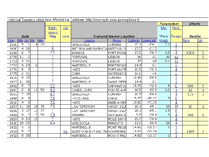
Caribbean Tsunamis Fatalities 1692 to the present Dominican Republic 1946 (2 events), 1865 deaths Haiti, 1842 300 deaths Jamaica, 1692 2000 deaths Costa Rica 1991, 2 deaths Panama, 1882 100 deaths Puerto Rico, 1918 142 deaths US Virgin Islands 1867, 30 deaths Martinique, 1902 100 deaths Venezuela, 1853 113 deaths Total Deaths: 4652 Courtesy of Paula Dunbar, 2007

Courtesy of Paula Dunbar, 2007 Tsunami Event Runups, Total number of Runups, and Deaths

Tsunami Runups from Distant Sources Cuba Dominican Republic US Virgin Islands Haiti Puerto Rico Netherlands Antilles Antigua & Barbuda Dominica Guadeloupe Martinique Venezuela St Vincent & Grenadines Barbados Panama Courtesy of Paula Dunbar, 2007

1755 Lisbon Earthquake • Mw 8. 75 -9 • Travel Time @ 6 -7 hours • Areas w/ Runup – – – Saba 6. 4 -7. 6 m Martinique 4. 6 m (drop) Antigua 3. 7 m Barbados (Carlisle Bay) 6. 1 m Samaná Bay, Dom. Rep. 3. 7 m – Santiago, Cuba “completely inundated” • No reports – Puerto Rico – Virgin Islands

Tsunami Runups in the Caribbean from Local and Regional Sources Puerto Rico Dominican Republic Guadeloupe US Virgin Islands British Virgin I Jamaica Netherlands Antilles St Kitts & Nevis Honduras Venezuela Costa Rica Panama Antigua & Barbuda Dominica Montserrat St Vincent & Grenadines Martinique St Lucia Barbados Grenada Trinidad & Tobago Courtesy of Paula Dunbar, 2007 Haiti Cuba

November 18, 1867 USVI Earthquake and Tsunami

Isoseismal map of the Puerto Rico earthquake of October 11, 1918 R-F Intensity Scale Modified after Reid and Taber, 1919

1918 Tsunami

Tsunami Runups 1918 Tsunami

• Maximum Water Height: • Valid values: . 01 to 525 The maximum water height above sea level in meters for this event. It is the height the tsunami reached above a reference level such as mean sea level but it is not always clear which reference level was used. If the type of measurement is a: • Tide Gauge - half of the maximum height (minus the normal tide)of a tsunami wave recorded at the coast by a tide gauge. • Deep Ocean Gauge ? half of the maximum height (minus the normal tide) of a tsunami wave recorded in the open ocean by a seafloor bottom pressure recording system. • Runup Height - the maximum elevation the wave reaches at the maximum inundation.

• Description of Number of Deaths from the Tsunami: – Valid values: 0 to 3 When a description was found in the historical literature instead of an actual number of deaths, this value was coded and listed in the Deaths D column. If the actual number of deaths was listed, a descriptor was also added for search purposes. – 0 = None – 1 = Few (~1 to 50 deaths) – 2 = Some (~51 to 100 deaths) – 3 = Many (~101 or more deaths)
 Source: Juan Carlos Moya and Aurelio Mercado")
Paleotsunami Deposits, Aguada (630 ybp) Source: Juan Carlos Moya and Aurelio Mercado

Pre Historic Tsunamis? 8, 000 ybp disturbance References Hubbard D. , Ramírez W. , Davis A. , Lawson G. , Oram J. , K Parsons. , Cuevas D. and Del Coro M. (2004) A preliminary model of Holocene coral-reef development in the Enriquillo Valley, SW Dominican Republic. Geological Society of America Abstracts with Programs, Vol. 36, No. 5, p. 313. Cuevas D. , Ramírez W. , Del Coro M. , and Hubbard D. (2004) Assessment of the response of a Holocene fossil coral reef to high sediment input: Implications to modern trends of reef degradation in high sedimentation environments. Geological Society of America Abstracts with Programs, Vol. 36, No. 5, p. 291.

Pre historic tsunamis?

What is today’s risk from tsunamis?
f907b541a474c34933ca6926801e42af.ppt